More like 'John McCalburn'
Narrow Results By
Decade
- 2020s 39
- 2010s 44
- 2000s 404
- 1990s 349
- 1980s 207
- 1970s 508
- 1960s 335
- 1950s 422
- 1940s 587
- 1930s 488
- 1920s 455
- 1910s 445
- 1900s 213
- 1890s 37
- 1880s 7
- 1870s 3
- 1860s 3
- 1850s 3
- 1840s 1
- 1830s 1
- 1820s 1
- 1810s 2
- 1800s 2
- 1790s 2
- 1780s 2
- 1770s 2
- 1760s 2
- 1750s 2
- 1740s 2
- 1730s 2
- 1720s 2
- 1710s 2
- 1700s 2
- 1690s 2
- 1680s 2
- 1670s 2
- 1660s 2
- 1650s 2
- 1640s 2
- 1630s 2
- 1620s 2
- 1610s 2
- 1600s 2
- 1590s 1
- 1580s 1
- 1570s 1
- 1560s 1
- 1550s 1
- 1540s 1
- 1530s 1
- 1520s 2
- 1510s 1
- 1500s 1
- 1490s 1
- 1480s 1
Subject
- Academic Disciplines 2
- Accidents 9
- Accidents - Automobile Accidents 19
- Accidents - Train Accidents 9
- Adornment 3
- Adornment - Jewelry 2
- Adornment - Lapel Pins 4
- Advertising Medium 32
- Advertising Medium - Business Cards 8
- Advertising Medium - Flyer 2
- Advertising Medium - Signs and Signboards 38
- Agricultural Tools and Equipment 29

H.T. Ceperley Estate 'Fairacres' Greenhouse Foundation Wall
https://search.heritageburnaby.ca/link/landmark862
- Repository
- Burnaby Heritage Planning
- Description
- The original rubble stone walls that formed the foundation for a greenhouses adjacent to the Steam Plant Building provided heat to several greenhouses on the estate propoerty. The Root House, which is to the north of the Greenhouse Foundation Wall, provided storage for the farm operation.
- Associated Dates
- 1908
- Formal Recognition
- Heritage Designation, Community Heritage Register
- Repository
- Burnaby Heritage Planning
- Geographic Access
- Deer Lake Avenue
- Associated Dates
- 1908
- Formal Recognition
- Heritage Designation, Community Heritage Register
- Enactment Type
- Bylaw No. 140665
- Enactment Date
- 23/11/1992
- Description
- The original rubble stone walls that formed the foundation for a greenhouses adjacent to the Steam Plant Building provided heat to several greenhouses on the estate propoerty. The Root House, which is to the north of the Greenhouse Foundation Wall, provided storage for the farm operation.
- Heritage Value
- The outbuildings at 'Fairacres' are a rare surviving architecturally-designed ensemble of agricultural structures that exist in complementary harmony with the main estate house. Architect Robert Mackay Fripp (1858-1917), an outspoken advocate of Arts and Crafts design, was retained by the Ceperleys to design several original outbuildings on their estate, which was designed as a country estate with a working farm that included over 10 acres of productive berry and vegetable fields, with a large kitchen garden, a root house to store food, an orchard, and greenhouses heated by steam. The agricultural potential of the Deer Lake area made it one of the first parts of the municipality to attract settlement. In 1909, the Ceperleys built three large greenhouses heated by an adjacent steam plant (Fairacres Steam Plant). The greenhouses featured granite foundation walls, including this one which remains intact. The Ceperleys employed a large staff to manage the estate's agricultural production, including Chinese farm labourers. Produce was grown for use at the estate, and for sale at local markets. Agricultural use of the estate continued when a Catholic order of Benedictine monks purchased the estate as part of the Priory of St. Joseph and the Seminary of Christ the King, and continued to farm the land until 1953.
- Defining Elements
- Key elements that define the heritage character of the ‘Fairacres’ Steam Plant Building include its: - overall spatial arrangement of the Greenhouse Foundation Wall in relation to the Steam Plant Building and the Root House - original rubble stone walls reflecting the Arts and Crafts design aesthetic of the estate buildings.
- Locality
- Deer Lake Park
- Historic Neighbourhood
- Burnaby Lake (Historic Neighbourhood)
- Planning Study Area
- Douglas-Gilpin Area
- Architect
- Robert Mackay Fripp
- Function
- Primary Historic--Outbuilding
- Community
- Burnaby
- Cadastral Identifier
- P.I.D. No. 004-493-311 Legal Description: Block 3 Except: Part subdivided by Plan 26865, District Lot 79, Group 1, New Westminster District, Plan 536
- Boundaries
- ‘Fairacres’ is comprised of a single municipally-owned property located at 6344 Deer Lake Avenue, Burnaby.
- Area
- 17,065.00
- Contributing Resource
- Landscape Feature
- Remains
- Ownership
- Public (local)
- Other Collection
- Burnaby Historical Society, Community Archives: Ceperley Photograph Album
- Documentation
- Heritage Site Files: PC77000 20. City of Burnaby Planning and Building Department, 4949 Canada Way, Burnaby, B.C., V5G 1M2
- Street Address
- 6344 Deer Lake Avenue
Images


H.T. Ceperley Estate 'Fairacres' Steam Plant Building
https://search.heritageburnaby.ca/link/landmark528
- Repository
- Burnaby Heritage Planning
- Description
- Designed in the British Arts and Crafts style, the ‘Fairacres’ Steam Plant Buiding is a single-storey wood frame building with a gabled roof that originally housed the apparatus for climate control in the greenhouses, formerly located to its north. The original rubble stone walls that formed the fo…
- Associated Dates
- 1908
- Formal Recognition
- Heritage Designation, Community Heritage Register
- Repository
- Burnaby Heritage Planning
- Geographic Access
- Deer Lake Avenue
- Associated Dates
- 1908
- Formal Recognition
- Heritage Designation, Community Heritage Register
- Enactment Type
- Bylaw No. 9807
- Enactment Date
- 23/11/1992
- Description
- Designed in the British Arts and Crafts style, the ‘Fairacres’ Steam Plant Buiding is a single-storey wood frame building with a gabled roof that originally housed the apparatus for climate control in the greenhouses, formerly located to its north. The original rubble stone walls that formed the foundation for the greenhouses stand adjacent. The Steam Plant Building stands as a pendant to the Root House, which is to the north of the former greenhouses.
- Heritage Value
- The outbuildings at 'Fairacres' are a rare surviving architecturally-designed ensemble of agricultural structures that exist in complementary harmony with the main estate house. Architect Robert Mackay Fripp (1858-1917), an outspoken advocate of Arts and Crafts design, was retained by the Ceperleys to design several original outbuildings on their estate. The Ceperleys operated 'Fairacres' with staff, a farm manager and workers, including Chinese, to grow produce for themselves and for sale at local markets. The Steam Plant Building illustrates the market gardening activity of the area around Deer Lake and its importance to the Ceperley family, which valued a year-round supply of fresh fruit and vegetables for the kitchen and flowers for the house. It also illustrates the cultural and aesthetic values of the Ceperleys in retaining an architect to design a functional outbuilding using an accepted and contemporary architectural style. Built in 1908, the Steam Plant Building was significantly altered in the 1960s and restored to its original design in 2000.
- Defining Elements
- Key elements that define the heritage character of the ‘Fairacres’ Steam Plant Building include its: - overall spatial arrangement of the Steam Plant Building in relation to the former greenhouses and the Root House - side gable roof with cedar shingle cladding. - tall brick chimney indicitive of the building's original function. - distinctive Arts and Crafts architectural features such as the shingle wall cladding with decorative shingling under window sills, deep eaves, and pebble-dashed concrete foundation walls - six-paned wooden-sash casement windows - simple functional interior features - rubble stone walls that formed the foundation for the greenhouses
- Locality
- Deer Lake Park
- Historic Neighbourhood
- Burnaby Lake (Historic Neighbourhood)
- Planning Study Area
- Douglas-Gilpin Area
- Architect
- Robert Mackay Fripp
- Function
- Primary Historic--Outbuilding
- Community
- Burnaby
- Cadastral Identifier
- P.I.D. No. 004-493-311 Legal Description: Block 3 Except: Part subdivided by Plan 26865, District Lot 79, Group 1, New Westminster District, Plan 536
- Boundaries
- ‘Fairacres’ is comprised of a single municipally-owned property located at 6344 Deer Lake Avenue, Burnaby.
- Area
- 17,065.00
- Contributing Resource
- Building
- Landscape Feature
- Ownership
- Public (local)
- Other Collection
- Burnaby Historical Society, Community Archives: Ceperley Photograph Album
- Documentation
- Heritage Site Files: PC77000 20. City of Burnaby Planning and Building Department, 4949 Canada Way, Burnaby, B.C., V5G 1M2
- Street Address
- 6344 Deer Lake Avenue
Images


Duncan & Margaret McGregor Estate 'Glen-Lyon' New Haven Barn
https://search.heritageburnaby.ca/link/landmark852
- Repository
- Burnaby Heritage Planning
- Description
- Designed in a vernacular architectural style, the New Haven Barn is a large gambrel-roofed barn located on the Edwardian era McGregor Estate 'Glen-Lyon,' overlooking the rich farmland of the Fraser River floodplain and near a ravine and forested area adjacent to Marine Drive in South Burnaby.
- Associated Dates
- 1939
- Formal Recognition
- Heritage Designation, Community Heritage Register
- Other Names
- Home of the Friendless, New Haven Borstal Home for Boys and Youthful Offenders, New Haven Correction Centre
- Street View URL
- Google Maps Street View
- Repository
- Burnaby Heritage Planning
- Other Names
- Home of the Friendless, New Haven Borstal Home for Boys and Youthful Offenders, New Haven Correction Centre
- Geographic Access
- Marine Drive
- Associated Dates
- 1939
- Formal Recognition
- Heritage Designation, Community Heritage Register
- Enactment Type
- Bylaw No. 12183
- Enactment Date
- 11/12/2006
- Description
- Designed in a vernacular architectural style, the New Haven Barn is a large gambrel-roofed barn located on the Edwardian era McGregor Estate 'Glen-Lyon,' overlooking the rich farmland of the Fraser River floodplain and near a ravine and forested area adjacent to Marine Drive in South Burnaby.
- Heritage Value
- The site is historically significant for its association with early social welfare and correctional reform. The estate was sold in 1926 to an inter-denominational religious organization called the Home of the Friendless, which used it as their B.C. headquarters. The organization was charged with several cases of abuse and neglect in 1937, after which a Royal Commission was formed that led to new legislation to regulate and license all private welfare institutions. 'Glen-Lyon' was sold to the provincial government, and was dedicated in 1939 by the Lt.-Gov. E.W. Hamber for use as the New Haven Borstal Home for Boys and Youthful Offenders (later renamed the New Haven Correction Centre). The Borstal movement originated in England in the late nineteenth century, as an alternative to sending young offenders and runaways to prisons by providing reformatories that focused on discipline and vocational skill. This site’s role as the first North American institution devoted to the Borstal School philosophy was historic, and influenced corrections programs across Canada. The New Haven Barn is a significant feature from its development in 1939 as the Borstal School, designed by Chief Provincial Architect Henry Whittaker of the Department of Public Works, and is the only remaining structure of its kind in Burnaby.
- Defining Elements
- Key elements that define the heritage character of the New Haven Barn include its: - gambrel-roofed barn with roof vent with finial, sliding hay loft and access doors, small multi-pane windows, and lapped wooden siding
- Historic Neighbourhood
- Fraser Arm (Historic Neighbourhood)
- Planning Study Area
- Big Bend Area
- Architect
- Henry Whittaker
- Function
- Primary Historic--Estate
- Community
- Burnaby
- Cadastral Identifier
- 003-004-661
- Boundaries
- 'Glen-Lyon' is comprised of a single residential lot located at 4250 Marine Drive, Burnaby.
- Area
- 230873.18
- Contributing Resource
- Building
- Ownership
- Private
- Names
- Whittaker, George
- New Haven Borstal Home for Boys and Youthful Offenders
- New Haven Correction Centre
- Borstal School
- Street Address
- 4250 Marine Drive
- Street View URL
- Google Maps Street View
Images


H.T. Ceperley Estate 'Fairacres' Garage & Stables
https://search.heritageburnaby.ca/link/landmark530
- Repository
- Burnaby Heritage Planning
- Description
- Designed in the British Arts and Crafts style, the ‘Fairacres’ Garage and Stables is a two-storey wood frame building located on the 'Fairacres' estate, situated to the north of the Chauffeur's Cottage; at the south end of the structure is a single vehicle garage and to the north are several stable…
- Associated Dates
- 1911
- Formal Recognition
- Heritage Designation, Community Heritage Register
- Street View URL
- Google Maps Street View
- Repository
- Burnaby Heritage Planning
- Geographic Access
- Deer Lake Avenue
- Associated Dates
- 1911
- Formal Recognition
- Heritage Designation, Community Heritage Register
- Enactment Type
- Bylaw No. 9807
- Enactment Date
- 23/11/1992
- Description
- Designed in the British Arts and Crafts style, the ‘Fairacres’ Garage and Stables is a two-storey wood frame building located on the 'Fairacres' estate, situated to the north of the Chauffeur's Cottage; at the south end of the structure is a single vehicle garage and to the north are several stables for carriage, riding, and draught horses, a coach house, and tack room; the upper floor was originally a hay loft.
- Heritage Value
- The outbuildings at 'Fairacres' are a rare surviving architecturally designed ensemble of agricultural structures that exist in complementary harmony with the main estate house. Architect Robert Mackay Fripp (1858-1917) was retained by the Ceperleys to design several original outbuildings on their estate at the same time as the main house was constructed. The Garage and Stables building is important as a record of its era when transportation modes were in transition and the horse-drawn carriage, while still in use, was giving way to the automobile. The relative spatial arrangements within the building are a valuable indication of the economy of space associated with the automobile, as compared to the horse. The extent of the stabling arrangements signifies not only the use of carriage horses but also the continued reliance on draught horses in farming activities in this era. As well, it is an indication of the fashionable nature of equestrianism for wealthy families during this time. The building is important as a demonstration of the aesthetics of the Ceperley family in having an architect-designed outbuilding and obtaining craftsmanship and materials of the highest quality for each structure on their estate.
- Defining Elements
- Key elements that define the heritage character of the 'Fairacres' Garage and Stables include its: - location within easy reach of the main house and in close proximity to the Chauffeur's Cottage - floor plan with the garage at one end, close to the Chauffeur's Cottage, and stables and equine facilities at the other - variety and complexity of the roofline, including gable wall dormers, gable-on-hip roof ends, and half-hip extensions - Arts and Crafts architectural features of the exterior such as the shingle wall cladding articulated with a chevron-patterned course of shingles at the first floor level; casement windows; and deep eaves with additional purlins to support the overhang - original stable doors with hand-made forged-iron door hardware - multi-paned wooden-sash windows, some retaining original wire glass
- Locality
- Deer Lake Park
- Historic Neighbourhood
- Burnaby Lake (Historic Neighbourhood)
- Planning Study Area
- Douglas-Gilpin Area
- Architect
- Robert Mackay Fripp
- Function
- Primary Historic--Outbuilding
- Community
- Burnaby
- Cadastral Identifier
- P.I.D. No. 004-493-311 Legal Description: Block 3 Except: Part subdivided by Plan 26865, District Lot 79, Group 1, New Westminster District, Plan 536
- Boundaries
- ‘Fairacres’ is comprised of a single municipally-owned property located at 6344 Deer Lake Avenue, Burnaby.
- Area
- 17,065.00
- Contributing Resource
- Building
- Landscape Feature
- Ownership
- Public (local)
- Other Collection
- Burnaby Historical Society, Community Archives: Ceperley Photograph Album
- Documentation
- Heritage Site Files: PC77000 20. City of Burnaby Planning and Building Department, 4949 Canada Way, Burnaby, B.C., V5G 1M2
- Street Address
- 6344 Deer Lake Avenue
- Street View URL
- Google Maps Street View
Images


H.T. Ceperley Estate 'Fairacres' Root House
https://search.heritageburnaby.ca/link/landmark527
- Repository
- Burnaby Heritage Planning
- Description
- The ‘Fairacres’ Root House is a long, low one-storey masonry building, measuring 4.6 metres by 9.1 metres, with massively buttressed concrete walls and foundations. Built into sloping ground adjacent to the location of the former greenhouses, the surviving orchard and the kitchen entrance of the ma…
- Associated Dates
- 1908
- Formal Recognition
- Heritage Designation, Community Heritage Register
- Repository
- Burnaby Heritage Planning
- Geographic Access
- Deer Lake Avenue
- Associated Dates
- 1908
- Formal Recognition
- Heritage Designation, Community Heritage Register
- Enactment Type
- Bylaw No. 9807
- Enactment Date
- 23/11/1992
- Description
- The ‘Fairacres’ Root House is a long, low one-storey masonry building, measuring 4.6 metres by 9.1 metres, with massively buttressed concrete walls and foundations. Built into sloping ground adjacent to the location of the former greenhouses, the surviving orchard and the kitchen entrance of the main house, 'Fairacres,' this functional structure was used as a frost-free store for fruit and vegetables for the family's use.
- Heritage Value
- The outbuildings at 'Fairacres' are a rare surviving architecturally-designed ensemble of agricultural structures that exist in complementary harmony with the main estate house. Architect Robert Mackay Fripp (1858-1917), an outspoken advocate of Arts and Crafts design, was retained by the Ceperleys to design several original outbuildings on their estate. The Root House is important as a rare surviving, and exceptionally large, example of this building type in the Vancouver region. Unusual in the fact that an architect designed a building of such modest aspirations, it is also remarkable in its method of construction. The use of concrete as a structural material is one of the earliest in the region and extraordinary for its use on such a modest vernacular outbuilding; root cellars were typically built of loose stone. Built in 1908, the Root House was significantly altered in the 1960s and restored to its original design in 2000. The building is significant as an indicator of the market gardening activity in the area around Deer Lake and of the country-house self-sufficiency practiced by the Ceperley family. The Root House illustrates the cultural, aesthetic, and lifestyle values of the Ceperleys in constructing such a large building for storing their own produce.
- Defining Elements
- The outbuildings at 'Fairacres' are a rare surviving architecturally-designed ensemble of agricultural structures that exist in complementary harmony with the main estate house. Architect Robert Mackay Fripp (1858-1917), an outspoken advocate of Arts and Crafts design, was retained by the Ceperleys to design several original outbuildings on their estate. The Root House is important as a rare surviving, and exceptionally large, example of this building type in the Vancouver region. Unusual in the fact that an architect designed a building of such modest aspirations, it is also remarkable in its method of construction. The use of concrete as a structural material is one of the earliest in the region and extraordinary for its use on such a modest vernacular outbuilding; root cellars were typically built of loose stone. Built in 1908, the Root House was significantly altered in the 1960s and restored to its original design in 2000. The building is significant as an indicator of the market gardening activity in the area around Deer Lake and of the country-house self-sufficiency practiced by the Ceperley family. The Root House illustrates the cultural, aesthetic, and lifestyle values of the Ceperleys in constructing such a large building for storing their own produce.
- Locality
- Deer Lake Park
- Historic Neighbourhood
- Burnaby Lake (Historic Neighbourhood)
- Planning Study Area
- Douglas-Gilpin Area
- Architect
- Robert Mackay Fripp
- Function
- Primary Historic--Outbuilding
- Secondary Historic--Food Storage
- Community
- Burnaby
- Cadastral Identifier
- P.I.D. No. 004-493-311 Legal Description: Block 3 Except: Part subdivided by Plan 26865, District Lot 79, Group 1, New Westminster District, Plan 536
- Boundaries
- ‘Fairacres’ is comprised of a single municipally-owned property located at 6344 Deer Lake Avenue, Burnaby.
- Area
- 17,065.00
- Contributing Resource
- Building
- Landscape Feature
- Ownership
- Public (local)
- Other Collection
- Burnaby Historical Society, Community Archives: Ceperley Photograph Album
- Documentation
- Heritage Site Files: PC77000 20. City of Burnaby Planning and Building Department, 4949 Canada Way, Burnaby, B.C., V5G 1M2
- Street Address
- 6344 Deer Lake Avenue
Images

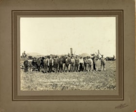
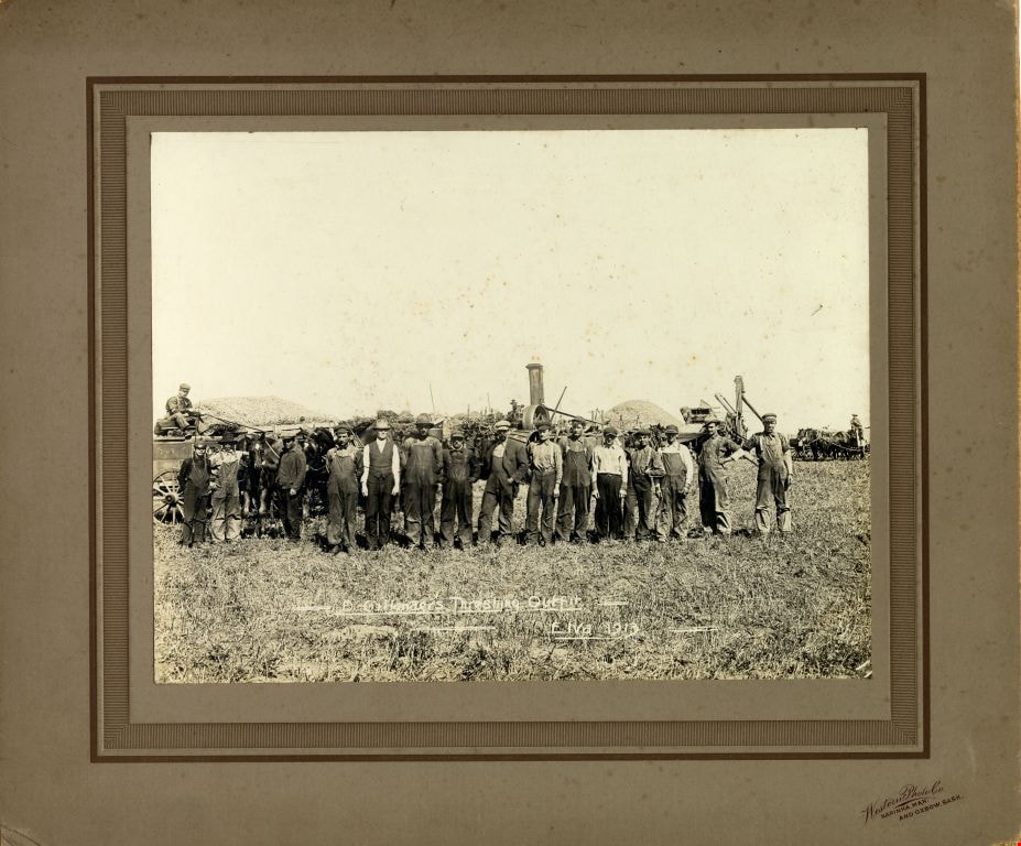
D. Gillander's Threshing Outfit
https://search.heritageburnaby.ca/link/museumdescription1102
- Repository
- Burnaby Village Museum
- Date
- 1913
- Collection/Fonds
- Burnaby Village Museum Photograph collection
- Description Level
- Item
- Physical Description
- 1 photograph : b&w ; 19 x 24.5 cm, mounted on card 30 x 35 cm
- Scope and Content
- Photograph of D. Gillander's Threshing Outfit standing together in a field in Elva, Manitoba, with teams of horses and threshing machinery visible in the background.
- Repository
- Burnaby Village Museum
- Collection/Fonds
- Burnaby Village Museum Photograph collection
- Description Level
- Item
- Physical Description
- 1 photograph : b&w ; 19 x 24.5 cm, mounted on card 30 x 35 cm
- Scope and Content
- Photograph of D. Gillander's Threshing Outfit standing together in a field in Elva, Manitoba, with teams of horses and threshing machinery visible in the background.
- Subjects
- Occupations - Agricultural Labourers
- Agricultural Tools and Equipment
- Transportation - Horses
- Accession Code
- HV972.165.207
- Access Restriction
- No restrictions
- Date
- 1913
- Media Type
- Photograph
- Scan Resolution
- 600
- Scan Date
- 1/8/2010
- Scale
- 100
- Photographer
- Western Photo Company
- Notes
- Photographer's mark on recto of card mount reads: "Western Photo Co. Napinka, Man. and Oxbow, Sask."
- Photographer's title (exposed) on recto reads: " -D. Gillander's Threshing Outfit - Elva 1913"
Images
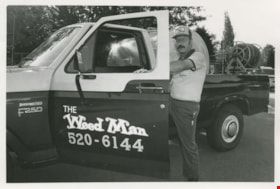
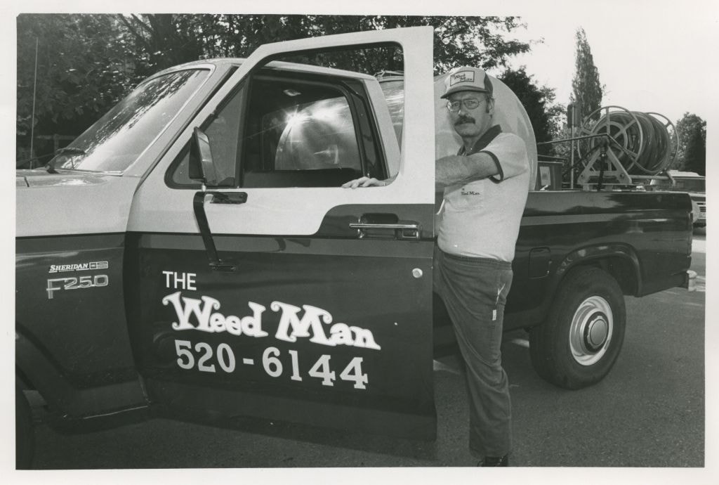
"The Weed Man"
https://search.heritageburnaby.ca/link/archivedescription58936
- Repository
- City of Burnaby Archives
- Date
- ca.1983
- Collection/Fonds
- Columbian Newspaper collection
- Description Level
- Item
- Physical Description
- 1 photograph : b&w ; 14 x 20.5 cm
- Scope and Content
- Photograph of a man posing with his pick-up truck containing lawn and landscaping equipment. His truck, hat, and shirt all read "The Weed Man."
- Repository
- City of Burnaby Archives
- Date
- ca.1983
- Collection/Fonds
- Columbian Newspaper collection
- Physical Description
- 1 photograph : b&w ; 14 x 20.5 cm
- Description Level
- Item
- Record No.
- 480-1385
- Access Restriction
- No restrictions
- Reproduction Restriction
- May be restricted by third party rights
- Accession Number
- 2009-01
- Scope and Content
- Photograph of a man posing with his pick-up truck containing lawn and landscaping equipment. His truck, hat, and shirt all read "The Weed Man."
- Subjects
- Agricultural Tools and Equipment - Gardening Equipment
- Maintenance Tools and Equipment
- Occupations
- Transportation - Trucks
- Media Type
- Photograph
- Photographer
- Hodge, Craig
- Notes
- Title based on contents of photograph
- Photographer's stamp on verso
- Note on verso reads: "Burnaby Today / A-8 / 47% PMT"
Images
![Grading at Oakalla, [1915] (date of original), copied 1991 thumbnail](/media/hpo/_Data/_Archives_Images/_Unrestricted/370/370-687.jpg?width=280)
Grading at Oakalla
https://search.heritageburnaby.ca/link/archivedescription38100
- Repository
- City of Burnaby Archives
- Date
- [1915] (date of original), copied 1991
- Collection/Fonds
- Burnaby Historical Society fonds
- Description Level
- Item
- Physical Description
- 1 photograph : b&w ; 2.9 x 5.2 cm print on contact sheet 20.7 x 26.7 cm
- Scope and Content
- Photograph of grading being done during construction at Oakalla Prison Farm. A team of Clydesdale horses is pulling a plough in front of a building with barred windows.
- Repository
- City of Burnaby Archives
- Date
- [1915] (date of original), copied 1991
- Collection/Fonds
- Burnaby Historical Society fonds
- Subseries
- Burnaby Image Bank subseries
- Physical Description
- 1 photograph : b&w ; 2.9 x 5.2 cm print on contact sheet 20.7 x 26.7 cm
- Description Level
- Item
- Record No.
- 370-687
- Access Restriction
- No restrictions
- Reproduction Restriction
- No known restrictions
- Accession Number
- BHS1999-03
- Scope and Content
- Photograph of grading being done during construction at Oakalla Prison Farm. A team of Clydesdale horses is pulling a plough in front of a building with barred windows.
- Subjects
- Transportation - Horses
- Buildings - Public - Detention Facilities
- Occupations - Labourers
- Agricultural Tools and Equipment - Plows
- Names
- Oakalla Prison Farm
- Media Type
- Photograph
- Notes
- Title based on caption of photograph
- 1 b&w copy negative accompanying
- Negative has a pink cast
- Caption at bottom of photograph reads, "Grading at Oakalla"
- Geographic Access
- Oakmount Crescent
- Street Address
- 5220 Oakmount Crescent
- Historic Neighbourhood
- Burnaby Lake (Historic Neighbourhood)
- Planning Study Area
- Oakalla Area
Images
![Grading at Oakalla, [1915] (date of original), copied 1991 thumbnail](/media/hpo/_Data/_Archives_Images/_Unrestricted/370/370-687.jpg)
![Grading at Oakalla, [1915] (date of original), copied 1991 thumbnail](/media/hpo/_Data/_Archives_Images/_Unrestricted/370/370-690.jpg?width=280)
Grading at Oakalla
https://search.heritageburnaby.ca/link/archivedescription38103
- Repository
- City of Burnaby Archives
- Date
- [1915] (date of original), copied 1991
- Collection/Fonds
- Burnaby Historical Society fonds
- Description Level
- Item
- Physical Description
- 1 photograph : b&w ; 2.9 x 5.2 cm print on contact sheet 20.7 x 26.7 cm
- Scope and Content
- Photograph of grading being done during construction at Oakalla Prison Farm. A team of horses is pulling a plough in front of a building.
- Repository
- City of Burnaby Archives
- Date
- [1915] (date of original), copied 1991
- Collection/Fonds
- Burnaby Historical Society fonds
- Subseries
- Burnaby Image Bank subseries
- Physical Description
- 1 photograph : b&w ; 2.9 x 5.2 cm print on contact sheet 20.7 x 26.7 cm
- Description Level
- Item
- Record No.
- 370-690
- Access Restriction
- No restrictions
- Reproduction Restriction
- No known restrictions
- Accession Number
- BHS1999-03
- Scope and Content
- Photograph of grading being done during construction at Oakalla Prison Farm. A team of horses is pulling a plough in front of a building.
- Subjects
- Agricultural Tools and Equipment - Plows
- Transportation - Horses
- Buildings - Public - Detention Facilities
- Occupations - Labourers
- Names
- Oakalla Prison Farm
- Media Type
- Photograph
- Notes
- Title based on caption of photograph
- 1 b&w copy negative accompanying
- Negative has a pink cast
- Caption at top of photograph reads, "Grading at Oakalla"
- Geographic Access
- Oakmount Crescent
- Street Address
- 5220 Oakmount Crescent
- Historic Neighbourhood
- Burnaby Lake (Historic Neighbourhood)
- Planning Study Area
- Oakalla Area
Images
![Grading at Oakalla, [1915] (date of original), copied 1991 thumbnail](/media/hpo/_Data/_Archives_Images/_Unrestricted/370/370-690.jpg)
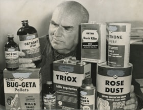
Columbian columnist William Hawley
https://search.heritageburnaby.ca/link/archivedescription45196
- Repository
- City of Burnaby Archives
- Date
- July 25, 1962
- Collection/Fonds
- Columbian Newspaper collection
- Description Level
- Item
- Physical Description
- 1 photograph : b&w ; 14.5 x 19 cm
- Scope and Content
- Photograph of Columbian farm and garden columnist William Hawley looking at tins and bottles of various types of bug sprays and garden sprays. He was the garden columnist for most of the 1960's, and prior to that he was a salesman and nutritionist for Brackman-Kerr feed store in New Westminster for…
- Repository
- City of Burnaby Archives
- Date
- July 25, 1962
- Collection/Fonds
- Columbian Newspaper collection
- Physical Description
- 1 photograph : b&w ; 14.5 x 19 cm
- Description Level
- Item
- Record No.
- 480-092
- Access Restriction
- No restrictions
- Reproduction Restriction
- Reproduce for fair dealing purposes only
- Accession Number
- 2003-02
- Scope and Content
- Photograph of Columbian farm and garden columnist William Hawley looking at tins and bottles of various types of bug sprays and garden sprays. He was the garden columnist for most of the 1960's, and prior to that he was a salesman and nutritionist for Brackman-Kerr feed store in New Westminster for 40 years. He and his wife Doreen were married for 52 years.
- Media Type
- Photograph
- Notes
- Title based on contents of photograph
Images
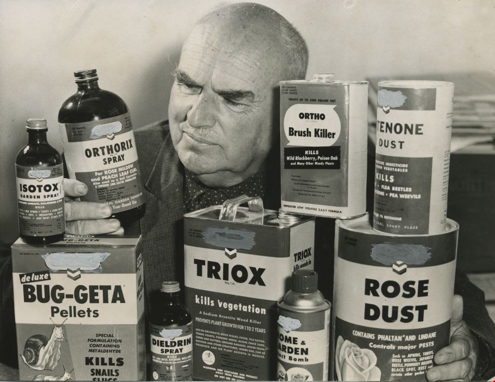

Digging In
https://search.heritageburnaby.ca/link/archivedescription34387
- Repository
- City of Burnaby Archives
- Date
- 1926
- Collection/Fonds
- Burnaby Historical Society fonds
- Description Level
- Item
- Physical Description
- 1 photograph : b&w ; 7.5 x 7 cm on page 17.5 x 26.5 cm
- Scope and Content
- Photograph of a steam shovel digging into a hill. A horse team pulling a dump wagon stand next to it. The location is unknown. This photograph appears to have been taken by Arthur Peers, who travelled through the Fraser River Valley and worked on the construction of the Trans-Provincial Highway dur…
- Repository
- City of Burnaby Archives
- Date
- 1926
- Collection/Fonds
- Burnaby Historical Society fonds
- Subseries
- Peers family subseries
- Physical Description
- 1 photograph : b&w ; 7.5 x 7 cm on page 17.5 x 26.5 cm
- Description Level
- Item
- Record No.
- 020-094
- Access Restriction
- No restrictions
- Reproduction Restriction
- No known restrictions
- Accession Number
- BHS2007-04
- Scope and Content
- Photograph of a steam shovel digging into a hill. A horse team pulling a dump wagon stand next to it. The location is unknown. This photograph appears to have been taken by Arthur Peers, who travelled through the Fraser River Valley and worked on the construction of the Trans-Provincial Highway during the later 1920s.
- Subjects
- Land Clearing
- Occupations - Labourers
- Transportation - Horses
- Transportation - Wagons
- Construction Tools and Equipment
- Media Type
- Photograph
- Photographer
- Peers, Arthur Francis "Mike"
- Notes
- Title based on caption accompanying photograph
Images

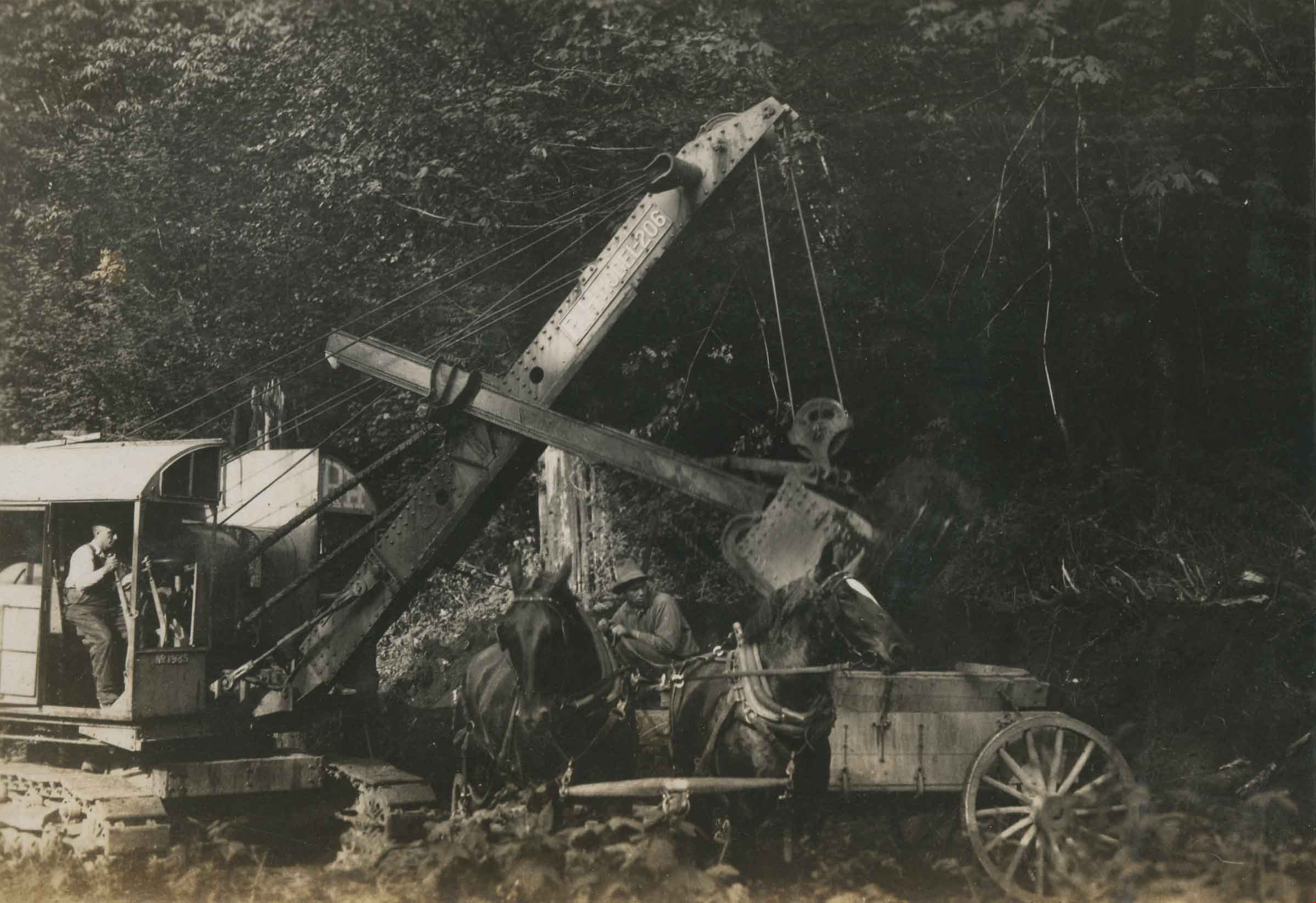
Loading a dump wagon
https://search.heritageburnaby.ca/link/archivedescription34383
- Repository
- City of Burnaby Archives
- Date
- 1926
- Collection/Fonds
- Burnaby Historical Society fonds
- Description Level
- Item
- Physical Description
- 1 photograph : b&w ; 7.1 x 10.2 cm on page 17.5 x 26.5 cm
- Scope and Content
- Photograph of a man using a steam shovel to load a dump wagon which is being pulled by a team of horses. Another man can be seen sitting on the wagon. Both are unidentified. This photograph appears to have been taken by Arthur Peers, who travelled through the Fraser River Valley and worked on the c…
- Repository
- City of Burnaby Archives
- Date
- 1926
- Collection/Fonds
- Burnaby Historical Society fonds
- Subseries
- Peers family subseries
- Physical Description
- 1 photograph : b&w ; 7.1 x 10.2 cm on page 17.5 x 26.5 cm
- Description Level
- Item
- Record No.
- 020-090
- Access Restriction
- No restrictions
- Reproduction Restriction
- No known restrictions
- Accession Number
- BHS2007-04
- Scope and Content
- Photograph of a man using a steam shovel to load a dump wagon which is being pulled by a team of horses. Another man can be seen sitting on the wagon. Both are unidentified. This photograph appears to have been taken by Arthur Peers, who travelled through the Fraser River Valley and worked on the construction of the Trans-Provincial Highway during the later 1920s.
- Subjects
- Occupations - Labourers
- Transportation - Horses
- Transportation - Wagons
- Construction Tools and Equipment
- Media Type
- Photograph
- Photographer
- Peers, Arthur Francis "Mike"
- Notes
- Title based on caption accompanying photograph
Images
![Hill brothers on a hay wagon, [190-] (date of original), copied 1977 thumbnail](/media/hpo/_Data/_BVM_Images/1977/1977_0123_0027_001.jpg?width=280)
Hill brothers on a hay wagon
https://search.heritageburnaby.ca/link/museumdescription621
- Repository
- Burnaby Village Museum
- Date
- [190-] (date of original), copied 1977
- Collection/Fonds
- Burnaby Village Museum Photograph collection
- Description Level
- Item
- Physical Description
- 1 photograph : b&w ; 20.2 x 25.2 cm print
- Scope and Content
- Photograph of three boys and a dog riding on a mound of hay on a wagon. There is a man leading the horse pulling the wagon. This photograph was reproduced in Michael Sone's book, "Pioneer Tales of Burnaby," pg. 31. The caption reads: "Hill brothers and pet dog hitching ride on hay wagon on father…
- Repository
- Burnaby Village Museum
- Collection/Fonds
- Burnaby Village Museum Photograph collection
- Description Level
- Item
- Physical Description
- 1 photograph : b&w ; 20.2 x 25.2 cm print
- Scope and Content
- Photograph of three boys and a dog riding on a mound of hay on a wagon. There is a man leading the horse pulling the wagon. This photograph was reproduced in Michael Sone's book, "Pioneer Tales of Burnaby," pg. 31. The caption reads: "Hill brothers and pet dog hitching ride on hay wagon on father's farm. Chap leading horse is probably remittance man often hired in those days." The description for photo 204-789, a cropped copy of this photo, identifies the boys as the Hill brothers Frank, Claude and Gerry and their pet dog riding on hay wagon on their father's farm.
- Subjects
- Animals - Dogs
- Agriculture - Farms
- Agriculture - Crops
- Occupations - Agricultural Labourers
- Transportation - Horses
- Transportation - Wagons
- Geographic Access
- Douglas Road
- Canada Way
- Street Address
- 4990 Canada Way
- Accession Code
- HV977.123.27
- Access Restriction
- No restrictions
- Reproduction Restriction
- No known restrictions
- Date
- [190-] (date of original), copied 1977
- Media Type
- Photograph
- Historic Neighbourhood
- Burnaby Lake (Historic Neighbourhood)
- Planning Study Area
- Douglas-Gilpin Area
- Scan Resolution
- 600
- Scan Date
- 2023-07-25
- Notes
- Title based on contents of photograph
Images
![Hill brothers on a hay wagon, [190-] (date of original), copied 1977 thumbnail](/media/hpo/_Data/_BVM_Images/1977/1977_0123_0027_001.jpg)
![Mr. Manuel with a plough, [192-] (date of original), copied 1991 thumbnail](/media/hpo/_Data/_Archives_Images/_Unrestricted/370/370-100.jpg?width=280)
Mr. Manuel with a plough
https://search.heritageburnaby.ca/link/archivedescription37512
- Repository
- City of Burnaby Archives
- Date
- [192-] (date of original), copied 1991
- Collection/Fonds
- Burnaby Historical Society fonds
- Description Level
- Item
- Physical Description
- 1 photograph : b&w ; 3.1 x 5.3 cm print on contact sheet 20.3 x 25.3 cm
- Scope and Content
- Photograph of Mr. Manuel working a plough pulled by two horses at Cassie Avenue (later the location of Metrotown).
- Repository
- City of Burnaby Archives
- Date
- [192-] (date of original), copied 1991
- Collection/Fonds
- Burnaby Historical Society fonds
- Subseries
- Burnaby Image Bank subseries
- Physical Description
- 1 photograph : b&w ; 3.1 x 5.3 cm print on contact sheet 20.3 x 25.3 cm
- Description Level
- Item
- Record No.
- 370-100
- Access Restriction
- No restrictions
- Reproduction Restriction
- No known restrictions
- Accession Number
- BHS1999-03
- Scope and Content
- Photograph of Mr. Manuel working a plough pulled by two horses at Cassie Avenue (later the location of Metrotown).
- Subjects
- Geographic Features - Fields
- Transportation - Horses
- Agricultural Tools and Equipment - Plows
- Occupations - Farmers
- Media Type
- Photograph
- Notes
- Title based on contents of photograph
- 1 b&w copy negative accompanying
- Geographic Access
- Cassie Avenue
- Historic Neighbourhood
- Central Park (Historic Neighbourhood)
- Planning Study Area
- Maywood Area
Images
![Mr. Manuel with a plough, [192-] (date of original), copied 1991 thumbnail](/media/hpo/_Data/_Archives_Images/_Unrestricted/370/370-100.jpg)

Ploughing at Nicholson farm
https://search.heritageburnaby.ca/link/archivedescription38261
- Repository
- City of Burnaby Archives
- Date
- 1931
- Collection/Fonds
- Burnaby Historical Society fonds
- Description Level
- Item
- Physical Description
- 1 photograph : b&w ; 10.5 x 15.4 cm
- Scope and Content
- Photograph of four farmers and a team of horses ploughing a field and the E.W. Nicholson farm in the Broadview district. In the background, to the right, can be seen the Dominion Bridge Co. building (at 3880 Henning Drive).
- Repository
- City of Burnaby Archives
- Date
- 1931
- Collection/Fonds
- Burnaby Historical Society fonds
- Subseries
- Margaret McCallum subseries
- Physical Description
- 1 photograph : b&w ; 10.5 x 15.4 cm
- Description Level
- Item
- Record No.
- 375-023
- Access Restriction
- No restrictions
- Reproduction Restriction
- No known restrictions
- Accession Number
- BHS1986-42
- Scope and Content
- Photograph of four farmers and a team of horses ploughing a field and the E.W. Nicholson farm in the Broadview district. In the background, to the right, can be seen the Dominion Bridge Co. building (at 3880 Henning Drive).
- Subjects
- Agriculture - Farms
- Occupations - Farmers
- Transportation - Horses
- Agricultural Tools and Equipment - Plows
- Media Type
- Photograph
- Notes
- Title based on caption
- A note on the back of the photograph reads: "Ploughing on farm of Mr. E.W. Nicholson - Boundary Road and Great Northern Rlwy. John McCallum in foreground. Dominion Bridge Co. in background.)
- Geographic Access
- Boundary Road
- Henning Drive
- Street Address
- 2550 Boundary Road
- 3880 Henning Drive
- Historic Neighbourhood
- Broadview (Historic Neighbourhood)
- Planning Study Area
- West Central Valley Area
Images

![Blythe Eagles in the garden, [1930] (date of original), copied 1996 thumbnail](/media/hpo/_Data/_Archives_Images/_Unrestricted/316/331-001.jpg?width=280)
Blythe Eagles in the garden
https://search.heritageburnaby.ca/link/archivedescription37183
- Repository
- City of Burnaby Archives
- Date
- [1930] (date of original), copied 1996
- Collection/Fonds
- Burnaby Historical Society fonds
- Description Level
- Item
- Physical Description
- 1 photograph : b&w ; 16.5 x 10 cm print
- Scope and Content
- Photograph of Blythe Eagles with his shirt off, working in the garden.
- Repository
- City of Burnaby Archives
- Date
- [1930] (date of original), copied 1996
- Collection/Fonds
- Burnaby Historical Society fonds
- Subseries
- Eagles family subseries
- Physical Description
- 1 photograph : b&w ; 16.5 x 10 cm print
- Description Level
- Item
- Record No.
- 331-001
- Access Restriction
- No restrictions
- Reproduction Restriction
- No known restrictions
- Accession Number
- BHS1996-21
- Scope and Content
- Photograph of Blythe Eagles with his shirt off, working in the garden.
- Names
- Eagles, Dr. Blythe
- Media Type
- Photograph
- Notes
- Title based on contents of photograph
- Geographic Access
- Sperling Avenue
- Street Address
- 5655 Sperling Avenue
- Historic Neighbourhood
- Burnaby Lake (Historic Neighbourhood)
- Planning Study Area
- Morley-Buckingham Area
Images
![Blythe Eagles in the garden, [1930] (date of original), copied 1996 thumbnail](/media/hpo/_Data/_Archives_Images/_Unrestricted/316/331-001.jpg)
![Chinese man in field, [ca. 1915] (date of original), copied 1989 thumbnail](/media/hpo/_Data/_BVM_Images/2018/2018_0041_0185_001.jpg?width=280)
Chinese man in field
https://search.heritageburnaby.ca/link/museumdescription10004
- Repository
- Burnaby Village Museum
- Date
- [ca. 1915] (date of original), copied 1989
- Collection/Fonds
- Burnaby Village Museum fonds
- Description Level
- Item
- Physical Description
- 1 photograph : b&w negative ; 35 mm
- Scope and Content
- Photograph of an unidentified Chinese man in a field with a hoe and young trees growing behind him. This field and orchard could be located on the Love family property.
- Repository
- Burnaby Village Museum
- Collection/Fonds
- Burnaby Village Museum fonds
- Series
- Jesse Love farmhouse series
- Subseries
- Love family photographs subseries
- Description Level
- Item
- Physical Description
- 1 photograph : b&w negative ; 35 mm
- Scope and Content
- Photograph of an unidentified Chinese man in a field with a hoe and young trees growing behind him. This field and orchard could be located on the Love family property.
- Subjects
- Geographic Features - Fields
- Agricultural Tools and Equipment - Gardening Equipment
- Agriculture - Orchards
- Plants - Trees
- Persons - Chinese Canadians
- Geographic Access
- Cumberland Street
- Street Address
- 7651 Cumberland Street
- Accession Code
- BV018.41.185
- Access Restriction
- No restrictions
- Reproduction Restriction
- May be restricted by third party rights
- Date
- [ca. 1915] (date of original), copied 1989
- Media Type
- Photograph
- Historic Neighbourhood
- East Burnaby (Historic Neighbourhood)
- Planning Study Area
- Cariboo-Armstrong Area
- Scan Resolution
- 2400
- Scan Date
- 4-Mar-2019
- Scale
- 100
- Notes
- Title based on contents of photograph
- 1 b&w copy print accompanying
Images
![Chinese man in field, [ca. 1915] (date of original), copied 1989 thumbnail](/media/hpo/_Data/_BVM_Images/2018/2018_0041_0185_001.jpg)
![Frances Fleming and Jack Waplington, [1934] thumbnail](/media/Hpo/_Data/_BVM_Images/2016/2016_0046_0083_001.jpg?width=280)
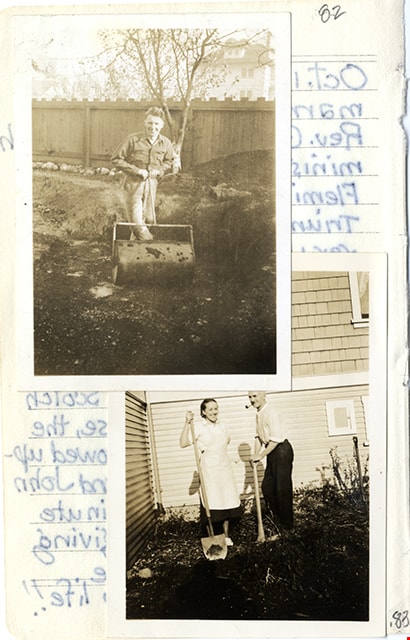
Frances Fleming and Jack Waplington
https://search.heritageburnaby.ca/link/museumdescription5128
- Repository
- Burnaby Village Museum
- Date
- [1934]
- Collection/Fonds
- Waplington family fonds
- Description Level
- Item
- Physical Description
- 1 photograph : sepia ; 8.5 x 6.5 cm
- Scope and Content
- Photograph of Frances Fleming (nee Waplington) with her father, Jack Waplington. They are standing outside an unidentified house and Frances is holding a shovel while Jack is holding a pickaxe and smoking a pipe.
- Repository
- Burnaby Village Museum
- Collection/Fonds
- Waplington family fonds
- Description Level
- Item
- Physical Description
- 1 photograph : sepia ; 8.5 x 6.5 cm
- Material Details
- Photograph is pasted to a small page from a notebook with photograph above overlapping the top left hand corner of the photo.
- Scope and Content
- Photograph of Frances Fleming (nee Waplington) with her father, Jack Waplington. They are standing outside an unidentified house and Frances is holding a shovel while Jack is holding a pickaxe and smoking a pipe.
- Accession Code
- BV016.46.83
- Access Restriction
- No restrictions
- Reproduction Restriction
- No known restrictions
- Date
- [1934]
- Media Type
- Photograph
- Scan Resolution
- 600
- Scan Date
- 13-Aug-2018
- Notes
- Title based on contents of photograph
- Photograph was attached to a small sheet of lined paper along with another photograph with handwritten text below and on back of page. Item is part of Photograph album BV016.46.52
- Handwritten entry by Frances Waplington on verso of page is dated "Oct. 11, 1915" and refers to her wedding day when she married Ray Fleming.
Images
![Frances Fleming and Jack Waplington, [1934] thumbnail](/media/Hpo/_Data/_BVM_Images/2016/2016_0046_0083_001.jpg)
George and Dorothy Easthope gardening
https://search.heritageburnaby.ca/link/archivedescription97778
- Repository
- City of Burnaby Archives
- Date
- 1947
- Collection/Fonds
- Burnaby Historical Society fonds
- Description Level
- Item
- Physical Description
- 1 photograph : col. ; 10 cm x 15 cm
- Scope and Content
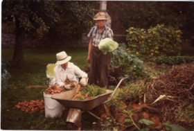
- Photograph of George and Dorothy Easthope harvesting vegetables from their backyard garden at 6711 Halifax Street. Dorothy sits on a chair separating the greens from a wheelbarrow of carrots as George stands next to her, holding out a cabbage to the camera.
- Repository
- City of Burnaby Archives
- Date
- 1947
- Collection/Fonds
- Burnaby Historical Society fonds
- Subseries
- Easthope family subseries
- Physical Description
- 1 photograph : col. ; 10 cm x 15 cm
- Description Level
- Item
- Record No.
- 451-015
- Access Restriction
- No restrictions
- Reproduction Restriction
- No known restrictions
- Accession Number
- BHS2003-06
- Scope and Content
- Photograph of George and Dorothy Easthope harvesting vegetables from their backyard garden at 6711 Halifax Street. Dorothy sits on a chair separating the greens from a wheelbarrow of carrots as George stands next to her, holding out a cabbage to the camera.
- Media Type
- Photograph
- Notes
- Title based on contents of photograph
- Note in black pen on verso reads: "Dorothy May (Parkes) Easthope (b.1903) and George Easthope (b. 1905). Back yard at residence, 6671 Halifax St., Burnaby B.C.
- Geographic Access
- Halifax Street
- Street Address
- 6671 Halifax Street
- Historic Neighbourhood
- Lochdale (Historic Neighbourhood)
- Planning Study Area
- Lochdale Area
Images

George Grant
https://search.heritageburnaby.ca/link/archivedescription36903
- Repository
- City of Burnaby Archives
- Date
- 1918 (date of original), copied 1992
- Collection/Fonds
- Burnaby Historical Society fonds
- Description Level
- Item
- Physical Description
- 1 photograph : b&w ; 7.9 x 11.8 cm print
- Scope and Content
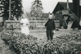
- Photograph of George Grant holding a rake for garden chores at 2540 Marlborough Avenue. The woman in the background may be his mother, Alice Grant.
- Repository
- City of Burnaby Archives
- Date
- 1918 (date of original), copied 1992
- Collection/Fonds
- Burnaby Historical Society fonds
- Subseries
- Burnaby Centennial Anthology subseries
- Physical Description
- 1 photograph : b&w ; 7.9 x 11.8 cm print
- Description Level
- Item
- Record No.
- 315-361
- Access Restriction
- No restrictions
- Reproduction Restriction
- No known restrictions
- Accession Number
- BHS1994-04
- Scope and Content
- Photograph of George Grant holding a rake for garden chores at 2540 Marlborough Avenue. The woman in the background may be his mother, Alice Grant.
- Media Type
- Photograph
- Notes
- Title based on contents of photograph
- Geographic Access
- Marlborough Avenue
- Street Address
- 6591 Marlborough Avenue
- Historic Neighbourhood
- Central Park (Historic Neighbourhood)
- Planning Study Area
- Marlborough Area
Images
