More like 'Bernard Hill farm'
Narrow Results By
Decade
- 2020s 31
- 2010s 28
- 2000s 221
- 1990s 291
- 1980s 137
- 1970s 435
- 1960s 180
- 1950s 330
- 1940s 445
- 1930s 489
- 1920s 430
- 1910s 387
- 1900s 209
- 1890s 33
- 1880s 9
- 1870s 2
- 1860s 2
- 1850s 2
- 1810s 1
- 1800s 1
- 1790s 1
- 1780s 1
- 1770s 1
- 1760s 1
- 1750s 1
- 1740s 1
- 1730s 1
- 1720s 1
- 1710s 1
- 1700s 1
- 1690s 1
- 1680s 1
- 1670s 1
- 1660s 1
- 1650s 1
- 1640s 1
- 1630s 1
- 1620s 1
- 1610s 1
- 1600s 1
- 1590s 1
- 1580s 1
- 1570s 1
- 1560s 1
- 1550s 1
- 1540s 1
- 1530s 1
- 1520s 2
- 1510s 1
- 1500s 1
- 1490s 1
- 1480s 1
Subject
- Academic Disciplines 1
- Accidents 5
- Accidents - Automobile Accidents 10
- Accidents - Train Accidents 9
- Adornment 1
- Adornment - Lapel Pins 1
- Advertising Medium 31
- Advertising Medium - Business Cards 8
- Advertising Medium - Flyer 2
- Advertising Medium - Signs and Signboards 37
- Aerial Photographs 1
- Agricultural Tools and Equipment 28
Creator
- Allan Studios 1
- Alymer-Small, Sidney 1
- Association for Living Historical Farms and Agricultural Museums, U.S.A. 1
- Association for Living History, Farm and Agricultural Museums 5
- Atkinson, J. C. (John Christopher), 1814-1900 1
- Atlee, Bob 1
- Barrowclough, G.A. 1
- Bartel, Mario 202
- Battistoni, Peter 9
- Beatty Bros Limited 1
- Bellinger, Bernard 6
- Bergson, George 10
![Chris Irwin clinic at the Burnaby Horsemen's Association, [2000] thumbnail](/media/hpo/_Data/_Archives_Images/_Unrestricted/535/535-2550.jpg?width=280)
Chris Irwin clinic at the Burnaby Horsemen's Association
https://search.heritageburnaby.ca/link/archivedescription97018
- Repository
- City of Burnaby Archives
- Date
- [2000]
- Collection/Fonds
- Burnaby NewsLeader photograph collection
- Description Level
- Item
- Physical Description
- 1 photograph (tiff) : col.
- Scope and Content
- Photograph of Chris Irwin working with a horse inside of a barn during a two-day clinic at the Burnaby Horsemen's Association.
- Repository
- City of Burnaby Archives
- Date
- [2000]
- Collection/Fonds
- Burnaby NewsLeader photograph collection
- Physical Description
- 1 photograph (tiff) : col.
- Description Level
- Item
- Record No.
- 535-2550
- Access Restriction
- No restrictions
- Reproduction Restriction
- No restrictions
- Accession Number
- 2018-12
- Scope and Content
- Photograph of Chris Irwin working with a horse inside of a barn during a two-day clinic at the Burnaby Horsemen's Association.
- Media Type
- Photograph
- Photographer
- Bartel, Mario
- Notes
- Title based on caption
- Collected by editorial for use in a July 2000 issue of the Burnaby NewsLeader
- Caption from metadata: "Canada's own horse whisperer, Chris Irwin, from Swift Current, Saskatchewan, demonstrates his techniques for winning over the trust and confidence of horses at a two-day clinic at the Burnaby Horseman's Association. The horse bowing its head is a sign the animal trusts its handler."
- Geographic Access
- Avalon Avenue
- Street Address
- 9080 Avalon Avenue
- Historic Neighbourhood
- Burnaby Lake (Historic Neighbourhood)
- Planning Study Area
- Burnaby Lake Area
Images
![Chris Irwin clinic at the Burnaby Horsemen's Association, [2000] thumbnail](/media/hpo/_Data/_Archives_Images/_Unrestricted/535/535-2550.jpg)
![Kitty riding Tom, [1905] thumbnail](/media/hpo/_Data/_Archives_Images/_Unrestricted/477/477-852.jpg?width=280)
Kitty riding Tom
https://search.heritageburnaby.ca/link/archivedescription39533
- Repository
- City of Burnaby Archives
- Date
- [1905]
- Collection/Fonds
- Peers Family and Hill Family fonds
- Description Level
- Item
- Physical Description
- 1 photograph : sepia ; 5.5 x 5.5 cm on page 21.5 x 28 cm (pasted in album)
- Scope and Content
- Photograph of Kitty Hill on her horse, Tom. A note with the photograph indicates that Tom lived from 1892 to 1914. The photograph was taken at the Hill family home known as Brookfield, on Deer Lake Avenue (the current site of the Burnaby Village Museum).
- Repository
- City of Burnaby Archives
- Date
- [1905]
- Collection/Fonds
- Peers Family and Hill Family fonds
- Physical Description
- 1 photograph : sepia ; 5.5 x 5.5 cm on page 21.5 x 28 cm (pasted in album)
- Description Level
- Item
- Record No.
- 477-852
- Access Restriction
- No restrictions
- Reproduction Restriction
- No known restrictions
- Accession Number
- 2007-12
- Scope and Content
- Photograph of Kitty Hill on her horse, Tom. A note with the photograph indicates that Tom lived from 1892 to 1914. The photograph was taken at the Hill family home known as Brookfield, on Deer Lake Avenue (the current site of the Burnaby Village Museum).
- Media Type
- Photograph
- Notes
- Title based on contents of photograph
- Geographic Access
- Deer Lake Avenue
- Street Address
- 6501 Deer Lake Avenue
- Historic Neighbourhood
- Burnaby Lake (Historic Neighbourhood)
- Planning Study Area
- Morley-Buckingham Area
Images
![Kitty riding Tom, [1905] thumbnail](/media/hpo/_Data/_Archives_Images/_Unrestricted/477/477-852.jpg)
![Lubbock barnyard, [1958 or 1959] thumbnail](/media/hpo/_Data/_Archives_Images/_Unrestricted/316/342-004.jpg?width=280)
Lubbock barnyard
https://search.heritageburnaby.ca/link/archivedescription37230
- Repository
- City of Burnaby Archives
- Date
- [1958 or 1959]
- Collection/Fonds
- Burnaby Historical Society fonds
- Description Level
- Item
- Physical Description
- 1 photograph : b&w ; 6.5 x 9.5 cm
- Scope and Content
- Photograph of the Lubbock barnyard, with cars from the 1930s and the 1950s parked along the side of the paddock and in front of the barn. Horses are visible in the background.
- Repository
- City of Burnaby Archives
- Date
- [1958 or 1959]
- Collection/Fonds
- Burnaby Historical Society fonds
- Subseries
- Lubbock family subseries
- Physical Description
- 1 photograph : b&w ; 6.5 x 9.5 cm
- Description Level
- Item
- Record No.
- 342-004
- Access Restriction
- No restrictions
- Reproduction Restriction
- Reproduce for fair dealing purposes only
- Accession Number
- BHS1994-02
- Scope and Content
- Photograph of the Lubbock barnyard, with cars from the 1930s and the 1950s parked along the side of the paddock and in front of the barn. Horses are visible in the background.
- Media Type
- Photograph
- Notes
- Title based on contents of photograph
- Geographic Access
- Grandview Highway
- Canada Way
- Burris Street
- Street Address
- 7803 Burris Street
- Historic Neighbourhood
- Burnaby Lake (Historic Neighbourhood)
- Planning Study Area
- Morley-Buckingham Area
Images
![Lubbock barnyard, [1958 or 1959] thumbnail](/media/hpo/_Data/_Archives_Images/_Unrestricted/316/342-004.jpg)

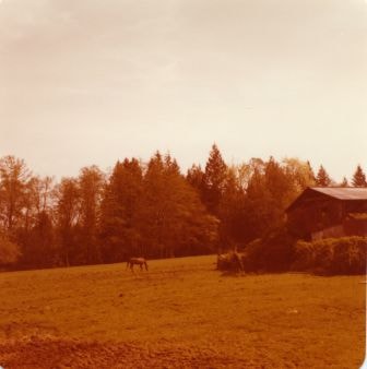
Pasture at Lubbock's farm
https://search.heritageburnaby.ca/link/archivedescription36521
- Repository
- City of Burnaby Archives
- Date
- 1977
- Collection/Fonds
- Burnaby Historical Society fonds
- Description Level
- Item
- Physical Description
- 1 photograph : col. ; 9 x 8.5 cm
- Scope and Content
- Photograph of the horse pasture at Lubbock's farm. The barn and surrounding shrubbery are visible on the left, and there is a horse grazing on the grass. Both the Burnaby Lake Riding Academy and the Burnaby Lake Saddle Club operated out of the Lubbock farm.
- Repository
- City of Burnaby Archives
- Date
- 1977
- Collection/Fonds
- Burnaby Historical Society fonds
- Subseries
- Lubbock family subseries
- Physical Description
- 1 photograph : col. ; 9 x 8.5 cm
- Description Level
- Item
- Record No.
- 289-010
- Access Restriction
- No restrictions
- Reproduction Restriction
- Reproduce for fair dealing purposes only
- Accession Number
- BHS1992-24
- Scope and Content
- Photograph of the horse pasture at Lubbock's farm. The barn and surrounding shrubbery are visible on the left, and there is a horse grazing on the grass. Both the Burnaby Lake Riding Academy and the Burnaby Lake Saddle Club operated out of the Lubbock farm.
- Media Type
- Photograph
- Notes
- Title based on contents of photograph
- Geographic Access
- Grandview Highway
- Canada Way
- Burris Street
- Street Address
- 7803 Burris Street
- Historic Neighbourhood
- Burnaby Lake (Historic Neighbourhood)
- Planning Study Area
- Morley-Buckingham Area
Images
![Tom, [1905] thumbnail](/media/hpo/_Data/_Archives_Images/_Unrestricted/477/477-851.jpg?width=280)
Tom
https://search.heritageburnaby.ca/link/archivedescription39532
- Repository
- City of Burnaby Archives
- Date
- [1905]
- Collection/Fonds
- Peers Family and Hill Family fonds
- Description Level
- Item
- Physical Description
- 1 photograph : b&w ; 5.5 x 5.5 cm on page 21.5 x 28 cm (pasted in album)
- Scope and Content
- Photograph of the Hill family horse, Tom, standing outside a barn at the Hill farm. The Hill family home was known as Brookfield and occupied the current site of the Burnaby Village Museum on Deer Lake Avenue.
- Repository
- City of Burnaby Archives
- Date
- [1905]
- Collection/Fonds
- Peers Family and Hill Family fonds
- Physical Description
- 1 photograph : b&w ; 5.5 x 5.5 cm on page 21.5 x 28 cm (pasted in album)
- Description Level
- Item
- Record No.
- 477-851
- Access Restriction
- No restrictions
- Reproduction Restriction
- No known restrictions
- Accession Number
- 2007-12
- Scope and Content
- Photograph of the Hill family horse, Tom, standing outside a barn at the Hill farm. The Hill family home was known as Brookfield and occupied the current site of the Burnaby Village Museum on Deer Lake Avenue.
- Media Type
- Photograph
- Notes
- Title based on contents of photograph
- Geographic Access
- Deer Lake Avenue
- Street Address
- 6501 Deer Lake Avenue
- Historic Neighbourhood
- Burnaby Lake (Historic Neighbourhood)
- Planning Study Area
- Morley-Buckingham Area
Images
![Tom, [1905] thumbnail](/media/hpo/_Data/_Archives_Images/_Unrestricted/477/477-851.jpg)
![Dog at Sperling and Broadway, [193-?] (date of original), copied 1992 thumbnail](/media/hpo/_Data/_Archives_Images/_Unrestricted/315/315-403.jpg?width=280)
Dog at Sperling and Broadway
https://search.heritageburnaby.ca/link/archivedescription36945
- Repository
- City of Burnaby Archives
- Date
- [193-?] (date of original), copied 1992
- Collection/Fonds
- Burnaby Historical Society fonds
- Description Level
- Item
- Physical Description
- 1 photograph : b&w ; 8.8 x 12.6 cm print
- Scope and Content
- Photograph of a dog in the yard between the Kneale family home and barn at 6726 Broadway (at Sperling).
- Repository
- City of Burnaby Archives
- Date
- [193-?] (date of original), copied 1992
- Collection/Fonds
- Burnaby Historical Society fonds
- Subseries
- Burnaby Centennial Anthology subseries
- Physical Description
- 1 photograph : b&w ; 8.8 x 12.6 cm print
- Description Level
- Item
- Record No.
- 315-403
- Access Restriction
- No restrictions
- Reproduction Restriction
- No known restrictions
- Accession Number
- BHS1994-04
- Scope and Content
- Photograph of a dog in the yard between the Kneale family home and barn at 6726 Broadway (at Sperling).
- Media Type
- Photograph
- Notes
- Title based on contents of photograph
- Geographic Access
- Broadway
- Street Address
- 6726 Broadway
- Historic Neighbourhood
- Lochdale (Historic Neighbourhood)
- Planning Study Area
- Sperling-Broadway Area
Images
![Dog at Sperling and Broadway, [193-?] (date of original), copied 1992 thumbnail](/media/hpo/_Data/_Archives_Images/_Unrestricted/315/315-403.jpg)

Farrington Chicken Ranch
https://search.heritageburnaby.ca/link/archivedescription35226
- Repository
- City of Burnaby Archives
- Date
- 1920 (date of original), copied 1986
- Collection/Fonds
- Burnaby Historical Society fonds
- Description Level
- Item
- Physical Description
- 1 photograph : b&w ; 12.7 x 17.8 cm print
- Scope and Content
- Photograph of the Farrington brothers' chicken ranch near Central Park at 3907 Chesham Avenue (later renumbered 5384 Chesham Avenue). Brothers Thomas Farrington and Richard Farrington founded Wheat Sheaf Poultry Ranch in 1919. The laying house is at the left, and the family home is at the right.
- Repository
- City of Burnaby Archives
- Date
- 1920 (date of original), copied 1986
- Collection/Fonds
- Burnaby Historical Society fonds
- Subseries
- Pioneer Tales subseries
- Physical Description
- 1 photograph : b&w ; 12.7 x 17.8 cm print
- Description Level
- Item
- Record No.
- 204-083
- Access Restriction
- No restrictions
- Reproduction Restriction
- No known restrictions
- Accession Number
- BHS1988-03
- Scope and Content
- Photograph of the Farrington brothers' chicken ranch near Central Park at 3907 Chesham Avenue (later renumbered 5384 Chesham Avenue). Brothers Thomas Farrington and Richard Farrington founded Wheat Sheaf Poultry Ranch in 1919. The laying house is at the left, and the family home is at the right.
- Subjects
- Buildings - Agricultural
- Animals - Poultry
- Agriculture - Poultry
- Buildings - Residential - Houses
- Media Type
- Photograph
- Notes
- Title based on contents of photograph
- Geographic Access
- Chesham Avenue
- Street Address
- 5384 Chesham Avenue
- Historic Neighbourhood
- Central Park (Historic Neighbourhood)
- Planning Study Area
- Garden Village Area
Images


Farrington Laying House
https://search.heritageburnaby.ca/link/archivedescription35227
- Repository
- City of Burnaby Archives
- Date
- 1920 (date of original), copied 1986
- Collection/Fonds
- Burnaby Historical Society fonds
- Description Level
- Item
- Physical Description
- 1 photograph : b&w ; 12.7 x 17.8 cm print
- Scope and Content
- Photograph of Farrington brothers' chicken laying house. Brothers Thomas Farrington and Richard Farrington founded Wheat Sheaf Poultry Ranch in 1919. It was located at 3907 Chesham Avenue (later renumbered 5384 Chesham Avenue).
- Repository
- City of Burnaby Archives
- Date
- 1920 (date of original), copied 1986
- Collection/Fonds
- Burnaby Historical Society fonds
- Subseries
- Pioneer Tales subseries
- Physical Description
- 1 photograph : b&w ; 12.7 x 17.8 cm print
- Description Level
- Item
- Record No.
- 204-084
- Access Restriction
- No restrictions
- Reproduction Restriction
- No known restrictions
- Accession Number
- BHS1988-03
- Scope and Content
- Photograph of Farrington brothers' chicken laying house. Brothers Thomas Farrington and Richard Farrington founded Wheat Sheaf Poultry Ranch in 1919. It was located at 3907 Chesham Avenue (later renumbered 5384 Chesham Avenue).
- Media Type
- Photograph
- Notes
- Title based on contents of photograph
- Geographic Access
- Chesham Avenue
- Street Address
- 5384 Chesham Avenue
- Historic Neighbourhood
- Central Park (Historic Neighbourhood)
- Planning Study Area
- Garden Village Area
Images


Olive Farrington Barber
https://search.heritageburnaby.ca/link/archivedescription35225
- Repository
- City of Burnaby Archives
- Date
- 1928 (date of original), copied 1986
- Collection/Fonds
- Burnaby Historical Society fonds
- Description Level
- Item
- Physical Description
- 1 photograph : b&w ; 12.7 x 17.8 cm print
- Scope and Content
- Photograph of Olive Farrington Barber in front of the Farrington brothers' chicken shed. Brothers Thomas Farrington and Richard Farrington founded Wheat Sheaf Poultry Ranch in 1919. It was located at 3907 Chesham Avenue (later renumbered 5384 Chesham Avenue).
- Repository
- City of Burnaby Archives
- Date
- 1928 (date of original), copied 1986
- Collection/Fonds
- Burnaby Historical Society fonds
- Subseries
- Pioneer Tales subseries
- Physical Description
- 1 photograph : b&w ; 12.7 x 17.8 cm print
- Description Level
- Item
- Record No.
- 204-082
- Access Restriction
- No restrictions
- Reproduction Restriction
- No known restrictions
- Accession Number
- BHS1988-03
- Scope and Content
- Photograph of Olive Farrington Barber in front of the Farrington brothers' chicken shed. Brothers Thomas Farrington and Richard Farrington founded Wheat Sheaf Poultry Ranch in 1919. It was located at 3907 Chesham Avenue (later renumbered 5384 Chesham Avenue).
- Media Type
- Photograph
- Notes
- Title based on contents of photograph
- Geographic Access
- Chesham Avenue
- Street Address
- 5384 Chesham Avenue
- Historic Neighbourhood
- Central Park (Historic Neighbourhood)
- Planning Study Area
- Garden Village Area
Images

![Clearing Douglas Road, [190-?] (date of original), copied 1977 thumbnail](/media/hpo/_Data/_BVM_Images/1977/1977_0099_0002_001.jpg?width=280)
Clearing Douglas Road
https://search.heritageburnaby.ca/link/museumdescription560
- Repository
- Burnaby Village Museum
- Date
- [190-?] (date of original), copied 1977
- Collection/Fonds
- Burnaby Village Museum Photograph collection
- Description Level
- Item
- Physical Description
- 1 photograph : b&w ; 20.2 x 25.2 cm print
- Scope and Content
- Photograph of men in work clothes clearing Doulgas Road. A group of men to the right side of the photograph have shovels in their hands and are clearing rocks from the road. There is a small girl in a blouse and skirt standing beside two horses pulling a cart. Behind her is a group of men in wor…
- Repository
- Burnaby Village Museum
- Collection/Fonds
- Burnaby Village Museum Photograph collection
- Description Level
- Item
- Physical Description
- 1 photograph : b&w ; 20.2 x 25.2 cm print
- Scope and Content
- Photograph of men in work clothes clearing Doulgas Road. A group of men to the right side of the photograph have shovels in their hands and are clearing rocks from the road. There is a small girl in a blouse and skirt standing beside two horses pulling a cart. Behind her is a group of men in work clothes as well. There is fenced land to the right of the photograph, and electric power poles and trees line both sides of the road. The accession register and inscription on the photograph identify this as Douglas Road (later renamed in part Canada Way). An annotation on the back of the photo reads: "Working on Douglas Road on hill above Burnaby Lake. No Date."
- Geographic Access
- Douglas Road
- Canada Way
- Accession Code
- HV977.99.2
- Access Restriction
- No restrictions
- Reproduction Restriction
- May be restricted by third party rights
- Date
- [190-?] (date of original), copied 1977
- Media Type
- Photograph
- Historic Neighbourhood
- Burnaby Lake (Historic Neighbourhood)
- Scan Resolution
- 600
- Scan Date
- 2023-07-11
- Notes
- Title based on contents of photograph
Images
![Clearing Douglas Road, [190-?] (date of original), copied 1977 thumbnail](/media/hpo/_Data/_BVM_Images/1977/1977_0099_0002_001.jpg)
Barn book
https://search.heritageburnaby.ca/link/museumlibrary4912
- Repository
- Burnaby Village Museum
- Author
- Beatty Bros Limited
- Publication Date
- c1931
- Call Number
- 631 BEA
- Repository
- Burnaby Village Museum
- Collection
- Special Collection
- Material Type
- Book
- Accession Code
- BV991.45.136
- Call Number
- 631 BEA
- Author
- Beatty Bros Limited
- Place of Publication
- London
- Publisher
- Beatty Bros., Ltd.
- Publication Date
- c1931
- Physical Description
- 334 p. : ill. : 25 cm.
- Library Subject (LOC)
- Barns
- Farm buildings
- Dairying
- Stables
- Catalogs
- Subjects
- Buildings
- Buildings - Agricultural
- Buildings - Agricultural - Barns
- Agriculture
- Agriculture - Dairy
- Names
- Oakalla Prison Farm
- Object History
- Salvaged from Oakalla Prison site in October 1991
- Notes
- Includes index.
Lubbock photographs from album
https://search.heritageburnaby.ca/link/archivedescription64493
- Repository
- City of Burnaby Archives
- Date
- 1945-1988
- Collection/Fonds
- Burnaby Historical Society fonds
- Description Level
- File
- Physical Description
- 130 photographs : b&w and col. ; 20.5 x 25.5 cm or smaller
- Scope and Content
- Photographs of the Lubbock family, including their riding stables and horses, family events, their pets, and landscape and travel photographs. These photographs were originally housed in a photographic album.
- Repository
- City of Burnaby Archives
- Date
- 1945-1988
- Collection/Fonds
- Burnaby Historical Society fonds
- Subseries
- Lubbock family subseries
- Physical Description
- 130 photographs : b&w and col. ; 20.5 x 25.5 cm or smaller
- Description Level
- File
- Record No.
- 342-046
- Access Restriction
- In Archives only
- Reproduction Restriction
- May be restricted by third party rights
- Accession Number
- BHS1994-02
- Scope and Content
- Photographs of the Lubbock family, including their riding stables and horses, family events, their pets, and landscape and travel photographs. These photographs were originally housed in a photographic album.
- Names
- Lubbock, Ainsly
- Lubbock, Beatrice "Bea"
- Lubbock, Elizabeth
- Lubbock, Gordon
- Lubbock, John
- Lubbock, John Barker
- Lubbock, Mina
- Media Type
- Photograph
- Notes
- Title based on contents of photograph
- Geographic Access
- Grandview Highway
- Canada Way
- Burris Street
- Street Address
- 7803 Burris Street
- Historic Neighbourhood
- Burnaby Lake (Historic Neighbourhood)
- Planning Study Area
- Morley-Buckingham Area
![Aerial View of Chinese Market Gardens on Marine Drive, [between 1950 and 1959] (date of original), 2017 (date of duplication) thumbnail](/media/hpo/_Data/_BVM_Images/2017/2017_0040_0001_001.jpg?width=280)
Aerial View of Chinese Market Gardens on Marine Drive
https://search.heritageburnaby.ca/link/museumdescription4296
- Repository
- Burnaby Village Museum
- Date
- [between 1950 and 1959] (date of original), 2017 (date of duplication)
- Collection/Fonds
- Herbert Yee Law family fonds
- Description Level
- Item
- Physical Description
- 1 photograph (jpg) : b&w
- Scope and Content
- Photograph is an aerial view looking south over the Chinese Market Gardens along Marine Drive in the Big Bend area of Burnaby.
- Repository
- Burnaby Village Museum
- Collection/Fonds
- Herbert Yee Law family fonds
- Description Level
- Item
- Physical Description
- 1 photograph (jpg) : b&w
- Scope and Content
- Photograph is an aerial view looking south over the Chinese Market Gardens along Marine Drive in the Big Bend area of Burnaby.
- Names
- Chinese Market Gardens
- Geographic Access
- Marine Drive
- Accession Code
- BV017.40.1
- Access Restriction
- No restrictions
- Reproduction Restriction
- May be restricted by third party rights
- Date
- [between 1950 and 1959] (date of original), 2017 (date of duplication)
- Media Type
- Photograph
- Historic Neighbourhood
- Fraser Arm (Historic Neighbourhood)
- Planning Study Area
- Big Bend Area
- Scan Resolution
- 600
- Scan Date
- 11/19/2017
- Scale
- 100
- Notes
- Title based on contents of photograph.
Images
![Aerial View of Chinese Market Gardens on Marine Drive, [between 1950 and 1959] (date of original), 2017 (date of duplication) thumbnail](/media/hpo/_Data/_BVM_Images/2017/2017_0040_0001_001.jpg)

Chinese Market Gardens
https://search.heritageburnaby.ca/link/archivedescription70542
- Repository
- City of Burnaby Archives
- Date
- 1949
- Collection/Fonds
- Gail Yip fonds
- Description Level
- Item
- Physical Description
- 1 photograph (jpeg) : b&w
- Scope and Content
- Photograph is an aerial view looking south over the Chinese Market Gardens along Marine Drive. The farm on the south side of Marine Drive, second from the east, is 4930 Marine Drive.
- Repository
- City of Burnaby Archives
- Date
- 1949
- Collection/Fonds
- Gail Yip fonds
- Physical Description
- 1 photograph (jpeg) : b&w
- Description Level
- Item
- Record No.
- 529-001
- Access Restriction
- No restrictions
- Reproduction Restriction
- Reproduce for fair dealing purposes only
- Accession Number
- 2012-04
- Scope and Content
- Photograph is an aerial view looking south over the Chinese Market Gardens along Marine Drive. The farm on the south side of Marine Drive, second from the east, is 4930 Marine Drive.
- Subjects
- Agriculture - Crops
- Agriculture - Farms
- Names
- Chinese Market Gardens
- Media Type
- Photograph
- Geographic Access
- Marine Drive
- Street Address
- 4930 Marine Drive
- Historic Neighbourhood
- Fraser Arm (Historic Neighbourhood)
- Planning Study Area
- Big Bend Area
Images

![Corn seller, [1999] thumbnail](/media/hpo/_Data/_Archives_Images/_Unrestricted/535/535-3298.jpg?width=280)
Corn seller
https://search.heritageburnaby.ca/link/archivedescription98220
- Repository
- City of Burnaby Archives
- Date
- [1999]
- Collection/Fonds
- Burnaby NewsLeader photograph collection
- Description Level
- Item
- Physical Description
- 1 photograph (tiff) : col.
- Scope and Content
- Photograph of an unidentified person holding up three ears of shucked corn toward the camera. The person is standing on the side of a road, and a bin of corn under a tarp is visible in the background.
- Repository
- City of Burnaby Archives
- Date
- [1999]
- Collection/Fonds
- Burnaby NewsLeader photograph collection
- Physical Description
- 1 photograph (tiff) : col.
- Description Level
- Item
- Record No.
- 535-3298
- Access Restriction
- No restrictions
- Reproduction Restriction
- No restrictions
- Accession Number
- 2018-12
- Scope and Content
- Photograph of an unidentified person holding up three ears of shucked corn toward the camera. The person is standing on the side of a road, and a bin of corn under a tarp is visible in the background.
- Subjects
- Agriculture - Crops
- Agriculture
- Media Type
- Photograph
- Notes
- Title based on contents of photograph
- Collected by editorial for use in an August 1999 issue of the Burnaby NewsLeader
Images
![Corn seller, [1999] thumbnail](/media/hpo/_Data/_Archives_Images/_Unrestricted/535/535-3298.jpg)
Heritage Seed Program : 1991 seed listing
https://search.heritageburnaby.ca/link/museumlibrary6698
- Repository
- Burnaby Village Museum
- Author
- Canadian Organic Growers
- Publication Date
- 1991
- Call Number
- 635 HER 1991
- Repository
- Burnaby Village Museum
- Collection
- Reference Collection
- Material Type
- Textual Record
- Call Number
- 635 HER 1991
- Author
- Canadian Organic Growers
- Place of Publication
- Uxbridge, Ont.
- Publisher
- Heritage Seed Program
- Publication Date
- 1991
- Physical Description
- 34 p. ; 28 cm.
- Library Subject (LOC)
- Seeds
- Periodicals
- Subjects
- Agriculture
- Agriculture - Crops
- Notes
- Includes index (back cover).
Heritage Seed Program : 1992-1993 seed listing
https://search.heritageburnaby.ca/link/museumlibrary6699
- Repository
- Burnaby Village Museum
- Author
- Canadian Organic Growers
- Publication Date
- 1991
- Call Number
- 635 HER 1992-1993
- Repository
- Burnaby Village Museum
- Collection
- Reference Collection
- Material Type
- Textual Record
- Call Number
- 635 HER 1992-1993
- Author
- Canadian Organic Growers
- Place of Publication
- Uxbridge, Ont.
- Publisher
- Heritage Seed Program
- Publication Date
- 1991
- Physical Description
- 41 p [2]. ; 28 cm.
- Library Subject (LOC)
- Seeds
- Periodicals
- Subjects
- Agriculture
- Agriculture - Crops
- Notes
- Includes index.

Heritage Seed Program : preserving and enjoying our horticultural heritage, April 1992, vol. 5, no. 1
https://search.heritageburnaby.ca/link/museumlibrary6697
- Repository
- Burnaby Village Museum
- Author
- Canadian Organic Growers
- Publication Date
- 1992
- Call Number
- 635 HER v. 5 no. 1
- Repository
- Burnaby Village Museum
- Collection
- Reference Collection
- Material Type
- Textual Record
- ISBN
- 0848-0753
- Call Number
- 635 HER v. 5 no. 1
- Author
- Canadian Organic Growers
- Place of Publication
- Uxbridge, Ont.
- Publisher
- Heritage Seed Program
- Publication Date
- 1992
- Physical Description
- v. : ill ; 28 cm.
- Library Subject (LOC)
- Seeds
- Periodicals
- Subjects
- Agriculture
- Agriculture - Crops
Heritage Seed Program : preserving and enjoying our horticultural heritage, December 1992, vol. 5, no. 3
https://search.heritageburnaby.ca/link/museumlibrary6695
- Repository
- Burnaby Village Museum
- Author
- Canadian Organic Growers
- Publication Date
- 1992
- Call Number
- 635 HER v. 5 no. 3
- Repository
- Burnaby Village Museum
- Collection
- Reference Collection
- Material Type
- Textual Record
- ISBN
- 0848-0753
- Call Number
- 635 HER v. 5 no. 3
- Author
- Canadian Organic Growers
- Place of Publication
- Uxbridge, Ont.
- Publisher
- Heritage Seed Program
- Publication Date
- 1992
- Physical Description
- v. : ill ; 28 cm.
- Library Subject (LOC)
- Seeds
- Periodicals
- Subjects
- Agriculture
- Agriculture - Crops
![Planning Map of Chinese Market Gardens on Marine Drive, [between 1950 and 1959] (date of original), 2017 (date of duplication) thumbnail](/media/hpo/_Data/_BVM_Images/2017/2017_0040_0002_001.jpg?width=280)
Planning Map of Chinese Market Gardens on Marine Drive
https://search.heritageburnaby.ca/link/museumdescription4297
- Repository
- Burnaby Village Museum
- Date
- [between 1950 and 1959] (date of original), 2017 (date of duplication)
- Collection/Fonds
- Herbert Yee Law family fonds
- Description Level
- Item
- Physical Description
- 1 photograph (tiff) : col. ; 300 dpi
- Scope and Content
- Scanned copy of a survey plan of district lots 163, 162, 157, 158, and 165, near the Chinese Market Gardens along Marine Drive.
- Repository
- Burnaby Village Museum
- Collection/Fonds
- Herbert Yee Law family fonds
- Description Level
- Item
- Physical Description
- 1 photograph (tiff) : col. ; 300 dpi
- Scope and Content
- Scanned copy of a survey plan of district lots 163, 162, 157, 158, and 165, near the Chinese Market Gardens along Marine Drive.
- History
- Survey plan of district lots 163, 162, 157, 158, and 165, which is primarily the area farmed by Chinese and Chinese-Canadian market gardeners around Marine Drive between Royal Oak and Mandeville (present-day Nelson). Two Chinese/Chinese Canadian land owners can be seen on the map: N.G. Wah Sing (or Ng Wah Sing) and Yee Law (or Herbert Law).
- Geographic Access
- Marine Drive
- Accession Code
- BV017.40.2
- Access Restriction
- No restrictions
- Reproduction Restriction
- No known restrictions
- Date
- [between 1950 and 1959] (date of original), 2017 (date of duplication)
- Media Type
- Cartographic Material
- Historic Neighbourhood
- Fraser Arm (Historic Neighbourhood)
- Planning Study Area
- Big Bend Area
- Scan Resolution
- 300
- Scan Date
- 11/19/2017
- Scale
- 100
- Notes
- Title based on contents of copy scan of map
- Herbert Yee Law was donor's father and this map may have originally been his copy of the city planning/engineering documents.
Images
![Planning Map of Chinese Market Gardens on Marine Drive, [between 1950 and 1959] (date of original), 2017 (date of duplication) thumbnail](/media/hpo/_Data/_BVM_Images/2017/2017_0040_0002_001.jpg)