More like 'Central Park Agricultural Hall Fair'
Narrow Results By
Subject
- Agricultural Tools and Equipment 2
- Agricultural Tools and Equipment - Gardening Equipment 3
- Agricultural Tools and Equipment - Plows 1
- Agriculture 1
- Agriculture - Crops 2
- Agriculture - Dairy 1
- Agriculture - Farms 5
- Agriculture - Fruit and Berries 1
- Animals - Dogs 1
- Buildings 1
- Buildings - Agricultural 5
- Buildings - Agricultural - Barns 7

Duncan & Margaret McGregor Estate 'Glen-Lyon' New Haven Barn
https://search.heritageburnaby.ca/link/landmark852
- Repository
- Burnaby Heritage Planning
- Description
- Designed in a vernacular architectural style, the New Haven Barn is a large gambrel-roofed barn located on the Edwardian era McGregor Estate 'Glen-Lyon,' overlooking the rich farmland of the Fraser River floodplain and near a ravine and forested area adjacent to Marine Drive in South Burnaby.
- Associated Dates
- 1939
- Formal Recognition
- Heritage Designation, Community Heritage Register
- Other Names
- Home of the Friendless, New Haven Borstal Home for Boys and Youthful Offenders, New Haven Correction Centre
- Street View URL
- Google Maps Street View
- Repository
- Burnaby Heritage Planning
- Other Names
- Home of the Friendless, New Haven Borstal Home for Boys and Youthful Offenders, New Haven Correction Centre
- Geographic Access
- Marine Drive
- Associated Dates
- 1939
- Formal Recognition
- Heritage Designation, Community Heritage Register
- Enactment Type
- Bylaw No. 12183
- Enactment Date
- 11/12/2006
- Description
- Designed in a vernacular architectural style, the New Haven Barn is a large gambrel-roofed barn located on the Edwardian era McGregor Estate 'Glen-Lyon,' overlooking the rich farmland of the Fraser River floodplain and near a ravine and forested area adjacent to Marine Drive in South Burnaby.
- Heritage Value
- The site is historically significant for its association with early social welfare and correctional reform. The estate was sold in 1926 to an inter-denominational religious organization called the Home of the Friendless, which used it as their B.C. headquarters. The organization was charged with several cases of abuse and neglect in 1937, after which a Royal Commission was formed that led to new legislation to regulate and license all private welfare institutions. 'Glen-Lyon' was sold to the provincial government, and was dedicated in 1939 by the Lt.-Gov. E.W. Hamber for use as the New Haven Borstal Home for Boys and Youthful Offenders (later renamed the New Haven Correction Centre). The Borstal movement originated in England in the late nineteenth century, as an alternative to sending young offenders and runaways to prisons by providing reformatories that focused on discipline and vocational skill. This site’s role as the first North American institution devoted to the Borstal School philosophy was historic, and influenced corrections programs across Canada. The New Haven Barn is a significant feature from its development in 1939 as the Borstal School, designed by Chief Provincial Architect Henry Whittaker of the Department of Public Works, and is the only remaining structure of its kind in Burnaby.
- Defining Elements
- Key elements that define the heritage character of the New Haven Barn include its: - gambrel-roofed barn with roof vent with finial, sliding hay loft and access doors, small multi-pane windows, and lapped wooden siding
- Historic Neighbourhood
- Fraser Arm (Historic Neighbourhood)
- Planning Study Area
- Big Bend Area
- Architect
- Henry Whittaker
- Function
- Primary Historic--Estate
- Community
- Burnaby
- Cadastral Identifier
- 003-004-661
- Boundaries
- 'Glen-Lyon' is comprised of a single residential lot located at 4250 Marine Drive, Burnaby.
- Area
- 230873.18
- Contributing Resource
- Building
- Ownership
- Private
- Names
- Whittaker, George
- New Haven Borstal Home for Boys and Youthful Offenders
- New Haven Correction Centre
- Borstal School
- Street Address
- 4250 Marine Drive
- Street View URL
- Google Maps Street View
Images


Copies of photographs from Esther (Love) Stanley albums
https://search.heritageburnaby.ca/link/museumdescription10003
- Repository
- Burnaby Village Museum
- Date
- [1915-1950] (date of originals), copied 1989
- Collection/Fonds
- Burnaby Village Museum fonds
- Description Level
- File
- Physical Description
- 36 photographs : b&w negatives ; 35 mm
- Scope and Content
- Photographs copied from various photograph albums including; Albert Paker, George Love, Gordon Love and Esther (Love) Stanley. Content includes: Love family in front of the piano inside parlour; Love family members with musical instruments inside parlour; Ben Brandrith and Robert Love in uniforms; …
- Repository
- Burnaby Village Museum
- Collection/Fonds
- Burnaby Village Museum fonds
- Series
- Jesse Love farmhouse series
- Subseries
- Love family photographs subseries
- Description Level
- File
- Physical Description
- 36 photographs : b&w negatives ; 35 mm
- Scope and Content
- Photographs copied from various photograph albums including; Albert Paker, George Love, Gordon Love and Esther (Love) Stanley. Content includes: Love family in front of the piano inside parlour; Love family members with musical instruments inside parlour; Ben Brandrith and Robert Love in uniforms; unidentified Asian man in field with hoe and young trees behind him; wedding cake from Frank Charles Stanley and Esther Love's wedding; land clearing for Love farmhouse; Jesse Love feeding chickens; Jesse and Hannah (Girlie) Love in hats outside on Love farm; large picnic on grass; four generations of Love family members; gatherings of Love family members outside; Love family posed in a car inside a studio (Will, Sarah, George, Phoebe and Martha); Leonard Love dressed as a boy scout; Martha (Dot) with children; Love family members celebrate centennial; Jesse Love and Martha (Dot) Love outside Love farmhouse; Love farmhouse with porch and garden; swing at Love farmhouse; Parker family in living room and view of the Love farmhouse from the front.
- Geographic Access
- Cumberland Street
- Street Address
- 7651 Cumberland Street
- Accession Code
- BV018.41.184
- Access Restriction
- No restrictions
- Reproduction Restriction
- May be restricted by third party rights
- Date
- [1915-1950] (date of originals), copied 1989
- Media Type
- Photograph
- Historic Neighbourhood
- East Burnaby (Historic Neighbourhood)
- Planning Study Area
- Cariboo-Armstrong Area
- Scan Date
- 4-Mar-2019
- Notes
- Title based on contents of photograph
- 36 b&w copy prints accompanying
![Louise Irwin in cherry tree, [1936] (date of original), copied 2004 thumbnail](/media/hpo/_Data/_BVM_Images/2019/2019_0032_0098_001.jpg?width=280)
Louise Irwin in cherry tree
https://search.heritageburnaby.ca/link/museumdescription15281
- Repository
- Burnaby Village Museum
- Date
- [1936] (date of original), copied 2004
- Collection/Fonds
- In the Shadow by the Sea collection
- Description Level
- Item
- Physical Description
- 1 photograph (tiff) : 300 dpi
- Scope and Content
- Photograph of Louise Irwin standing on a limb of a cherry tree in the yard of the Irwin family home on the site of the Barnet Lumber Mill. The cherry tree is in full bloom with cherry blossoms.
- Repository
- Burnaby Village Museum
- Collection/Fonds
- In the Shadow by the Sea collection
- Description Level
- Item
- Physical Description
- 1 photograph (tiff) : 300 dpi
- Scope and Content
- Photograph of Louise Irwin standing on a limb of a cherry tree in the yard of the Irwin family home on the site of the Barnet Lumber Mill. The cherry tree is in full bloom with cherry blossoms.
- Geographic Access
- Burrard Inlet
- Accession Code
- BV019.32.98
- Access Restriction
- No restrictions
- Reproduction Restriction
- No known restrictions
- Date
- [1936] (date of original), copied 2004
- Media Type
- Photograph
- Historic Neighbourhood
- Barnet (Historic Neighbourhood)
- Planning Study Area
- Burnaby Mountain Area
- Notes
- Title based on contents of photograph
Images
![Louise Irwin in cherry tree, [1936] (date of original), copied 2004 thumbnail](/media/hpo/_Data/_BVM_Images/2019/2019_0032_0098_001.jpg)
![Louise with cherry blossoms, [1937] (date of original), copied 2004 thumbnail](/media/hpo/_Data/_BVM_Images/2019/2019_0032_0095_001.jpg?width=280)
Louise with cherry blossoms
https://search.heritageburnaby.ca/link/museumdescription15278
- Repository
- Burnaby Village Museum
- Date
- [1937] (date of original), copied 2004
- Collection/Fonds
- In the Shadow by the Sea collection
- Description Level
- Item
- Physical Description
- 1 photograph (tiff) : 300 dpi
- Scope and Content
- Photograph of Louise Irwin standing under a cherry tree that is in full bloom with cherry blossoms. The tree is in the yard of the Irwin family home on the site of the Barnet Lumber Mill.
- Repository
- Burnaby Village Museum
- Collection/Fonds
- In the Shadow by the Sea collection
- Description Level
- Item
- Physical Description
- 1 photograph (tiff) : 300 dpi
- Scope and Content
- Photograph of Louise Irwin standing under a cherry tree that is in full bloom with cherry blossoms. The tree is in the yard of the Irwin family home on the site of the Barnet Lumber Mill.
- Geographic Access
- Burrard Inlet
- Accession Code
- BV019.32.95
- Access Restriction
- No restrictions
- Reproduction Restriction
- No known restrictions
- Date
- [1937] (date of original), copied 2004
- Media Type
- Photograph
- Historic Neighbourhood
- Barnet (Historic Neighbourhood)
- Planning Study Area
- Burnaby Mountain Area
- Notes
- Title based on contents of photograph
Images
![Louise with cherry blossoms, [1937] (date of original), copied 2004 thumbnail](/media/hpo/_Data/_BVM_Images/2019/2019_0032_0095_001.jpg)
![Elworth decorated for the wedding of Warren Bateman, [21 Sept. 1932] thumbnail](/media/hpo/_Data/_BVM_Images/1974/197400900005.jpg?width=280)
Elworth decorated for the wedding of Warren Bateman
https://search.heritageburnaby.ca/link/museumdescription968
- Repository
- Burnaby Village Museum
- Date
- [21 Sept. 1932]
- Collection/Fonds
- E.W. Bateman family fonds
- Description Level
- Item
- Physical Description
- 1 photograph : b&w ; 12.3 x 17.2 cm
- Scope and Content
- Photograph of the interior of "Elworth" decorated with flowers and greenery for the occasion of Warren Stafford Bateman and Winifred Dare Webster's wedding which took place on September 21, 1932. The fireplace and mantle are seen in the centre. Warren Bateman was the son of Edwin W. Bateman and Ca…
- Repository
- Burnaby Village Museum
- Collection/Fonds
- E.W. Bateman family fonds
- Description Level
- Item
- Physical Description
- 1 photograph : b&w ; 12.3 x 17.2 cm
- Scope and Content
- Photograph of the interior of "Elworth" decorated with flowers and greenery for the occasion of Warren Stafford Bateman and Winifred Dare Webster's wedding which took place on September 21, 1932. The fireplace and mantle are seen in the centre. Warren Bateman was the son of Edwin W. Bateman and Catherine "Cassie" (Dale) Bateman. Edwin and his second wife, Mary (Dale) Bateman lived at "Elworth", 6501 Deer Lake Avenue from 1922.
- Accession Code
- HV974.90.5
- Access Restriction
- No restrictions
- Reproduction Restriction
- No known restrictions
- Date
- [21 Sept. 1932]
- Media Type
- Photograph
- Related Material
- For a closer view of the fireplace and the mantle, see photograph HV974.90.6
- Scan Resolution
- 600
- Scan Date
- 2023-04-25
- Photographer
- Lorimy, G.
- Notes
- Title based on contents of photograph
- 1 b&w copy print and copy negative accompanying
- Stamp on verso of photograph reads: "The Edmonds Studio / (G. Lorimy, Photographer) / 1188 Edmonds St. / Phone New Westminster 1618L1."
- Annotation in pencil on the back of the photo reads: "Warren and Winnie'sWedding."
Images
![Elworth decorated for the wedding of Warren Bateman, [21 Sept. 1932] thumbnail](/media/hpo/_Data/_BVM_Images/1974/197400900005.jpg)
![Elworth decorated for the wedding of Warren Bateman, [21 Sept. 1932] (date of original), copied [1974] thumbnail](/media/hpo/_Data/_BVM_Images/1974/197400900006.jpg?width=280)
Elworth decorated for the wedding of Warren Bateman
https://search.heritageburnaby.ca/link/museumdescription969
- Repository
- Burnaby Village Museum
- Date
- [21 Sept. 1932] (date of original), copied [1974]
- Collection/Fonds
- E.W. Bateman family fonds
- Description Level
- Item
- Physical Description
- 1 photograph : b&w ; 20.5 x 25.3 cm print
- Scope and Content
- Photograph of the interior of "Elworth" decorated with flowers and greenery for the occasion of Warren Stafford Bateman and Winifred Dare Webster's wedding which took place on September 21, 1932. The fireplace and mantle are seen in the centre, with a photograph and ornaments on it. According to …
- Repository
- Burnaby Village Museum
- Collection/Fonds
- E.W. Bateman family fonds
- Description Level
- Item
- Physical Description
- 1 photograph : b&w ; 20.5 x 25.3 cm print
- Scope and Content
- Photograph of the interior of "Elworth" decorated with flowers and greenery for the occasion of Warren Stafford Bateman and Winifred Dare Webster's wedding which took place on September 21, 1932. The fireplace and mantle are seen in the centre, with a photograph and ornaments on it. According to the donor, the girl in the photograph is the niece of Warren Batemen, whose married name became Mrs. Catherine Levins. Warren Bateman was the son of Edwin W. Batemen and Catherine "Cassie" (Dale) Bateman. Edwin and his second wife, Mary (Dale) Bateman lived at "Elworth", 6501 Deer Lake Avenue from 1922.
- Accession Code
- HV974.90.6
- Access Restriction
- No restrictions
- Reproduction Restriction
- No known restrictions
- Date
- [21 Sept. 1932] (date of original), copied [1974]
- Media Type
- Photograph
- Related Material
- For a wider view of the room, see photograph HV974.90.5
- Scan Resolution
- 600
- Scan Date
- 2023-04-25
- Notes
- Title based on contents of photograph
- 1 b&w copy negative accompanying
- Stamp on verso of photograph reads: "Better Pictures / NuGloss / Photo Finish / Vancouver Drug Co. / Limited / B71"
Images
![Elworth decorated for the wedding of Warren Bateman, [21 Sept. 1932] (date of original), copied [1974] thumbnail](/media/hpo/_Data/_BVM_Images/1974/197400900006.jpg)
![Hart House flowers, [between 1930 and 1934] (date of original), copied 1991 thumbnail](/media/hpo/_Data/_Archives_Images/_Unrestricted/370/370-575.jpg?width=280)
Hart House flowers
https://search.heritageburnaby.ca/link/archivedescription37988
- Repository
- City of Burnaby Archives
- Date
- [between 1930 and 1934] (date of original), copied 1991
- Collection/Fonds
- Burnaby Historical Society fonds
- Description Level
- Item
- Physical Description
- 1 photograph : b&w ; 3.1 x 5.3 cm print on contact sheet 20.7 x 26.2 cm
- Scope and Content
- Photograph of a field of flowers at Hart House.
- Repository
- City of Burnaby Archives
- Date
- [between 1930 and 1934] (date of original), copied 1991
- Collection/Fonds
- Burnaby Historical Society fonds
- Subseries
- Burnaby Image Bank subseries
- Physical Description
- 1 photograph : b&w ; 3.1 x 5.3 cm print on contact sheet 20.7 x 26.2 cm
- Description Level
- Item
- Record No.
- 370-575
- Access Restriction
- No restrictions
- Reproduction Restriction
- No known restrictions
- Accession Number
- BHS1999-03
- Scope and Content
- Photograph of a field of flowers at Hart House.
- Subjects
- Plants - Flowers
- Media Type
- Photograph
- Notes
- Title based on contents of photograph
- 1 b&w copy negative accompanying
- Geographic Access
- Deer Lake Avenue
- Street Address
- 6664 Deer Lake Avenue
- Historic Neighbourhood
- Burnaby Lake (Historic Neighbourhood)
- Planning Study Area
- Morley-Buckingham Area
Images
![Hart House flowers, [between 1930 and 1934] (date of original), copied 1991 thumbnail](/media/hpo/_Data/_Archives_Images/_Unrestricted/370/370-575.jpg)
![Sperling and Broadway, [193-?] (date of original), copied 1992 thumbnail](/media/hpo/_Data/_Archives_Images/_Unrestricted/315/315-400.jpg?width=280)
Sperling and Broadway
https://search.heritageburnaby.ca/link/archivedescription36942
- Repository
- City of Burnaby Archives
- Date
- [193-?] (date of original), copied 1992
- Collection/Fonds
- Burnaby Historical Society fonds
- Description Level
- Item
- Physical Description
- 1 photograph : b&w ; 8.8 x 12.7 cm print
- Scope and Content
- Photograph of flowers beside the road at Sperling Avenue and Broadway.
- Repository
- City of Burnaby Archives
- Date
- [193-?] (date of original), copied 1992
- Collection/Fonds
- Burnaby Historical Society fonds
- Subseries
- Burnaby Centennial Anthology subseries
- Physical Description
- 1 photograph : b&w ; 8.8 x 12.7 cm print
- Description Level
- Item
- Record No.
- 315-400
- Access Restriction
- No restrictions
- Reproduction Restriction
- No known restrictions
- Accession Number
- BHS1994-04
- Scope and Content
- Photograph of flowers beside the road at Sperling Avenue and Broadway.
- Media Type
- Photograph
- Notes
- Title based on contents of photograph
- Geographic Access
- Sperling Avenue
- Broadway
- Historic Neighbourhood
- Lochdale (Historic Neighbourhood)
- Planning Study Area
- Sperling-Broadway Area
Images
![Sperling and Broadway, [193-?] (date of original), copied 1992 thumbnail](/media/hpo/_Data/_Archives_Images/_Unrestricted/315/315-400.jpg)
Barn book
https://search.heritageburnaby.ca/link/museumlibrary4912
- Repository
- Burnaby Village Museum
- Author
- Beatty Bros Limited
- Publication Date
- c1931
- Call Number
- 631 BEA
- Repository
- Burnaby Village Museum
- Collection
- Special Collection
- Material Type
- Book
- Accession Code
- BV991.45.136
- Call Number
- 631 BEA
- Author
- Beatty Bros Limited
- Place of Publication
- London
- Publisher
- Beatty Bros., Ltd.
- Publication Date
- c1931
- Physical Description
- 334 p. : ill. : 25 cm.
- Library Subject (LOC)
- Barns
- Farm buildings
- Dairying
- Stables
- Catalogs
- Subjects
- Buildings
- Buildings - Agricultural
- Buildings - Agricultural - Barns
- Agriculture
- Agriculture - Dairy
- Names
- Oakalla Prison Farm
- Object History
- Salvaged from Oakalla Prison site in October 1991
- Notes
- Includes index.
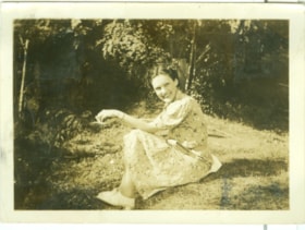
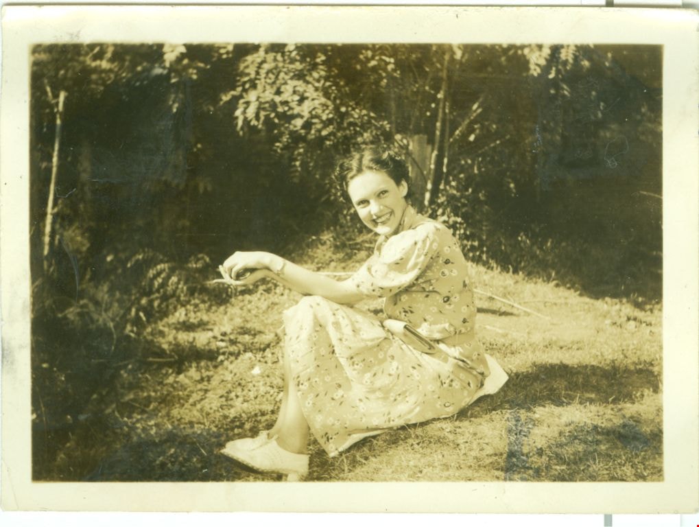
Kay
https://search.heritageburnaby.ca/link/museumdescription2711
- Repository
- Burnaby Village Museum
- Date
- July 25, 1937
- Collection/Fonds
- Hawkshaw family fonds
- Description Level
- Item
- Physical Description
- 1 photograph : sepia ; 5.5 x 8 cm
- Scope and Content
- Photograph of a woman named Kay seated on the grass of Mabel Hawkshaw's home located at 3908 Deer Lake Avenue (R.F. Anderson house - 6504 Deer Lake Avenue). Gardens and trees are visible behind.
- Repository
- Burnaby Village Museum
- Collection/Fonds
- Hawkshaw family fonds
- Description Level
- Item
- Physical Description
- 1 photograph : sepia ; 5.5 x 8 cm
- Scope and Content
- Photograph of a woman named Kay seated on the grass of Mabel Hawkshaw's home located at 3908 Deer Lake Avenue (R.F. Anderson house - 6504 Deer Lake Avenue). Gardens and trees are visible behind.
- Subjects
- Plants - Trees
- Plants - Grasses
- Geographic Access
- Deer Lake Avenue
- Accession Code
- BV996.6.152
- Access Restriction
- No restrictions
- Reproduction Restriction
- No known restrictions
- Date
- July 25, 1937
- Media Type
- Photograph
- Historic Neighbourhood
- Burnaby Lake (Historic Neighbourhood)
- Planning Study Area
- Morley-Buckingham Area
- Scan Resolution
- 600
- Scan Date
- 2/24/2011
- Scale
- 100
- Notes
- Title based on contents of photograph
- Caption for photograph reads: "Kay / '1937' / 'Edition'"
- Photograph is part of photograph album BV996.6.1
Images
![Map of proposed provincial exhibition site at Burnaby Lake, [between 1929 and 1931] thumbnail](/media/hpo/_Data/_BVM_Cartographic_Material/2017/2017_0002_0009_005.jpg?width=280)
Map of proposed provincial exhibition site at Burnaby Lake
https://search.heritageburnaby.ca/link/museumdescription8703
- Repository
- Burnaby Village Museum
- Date
- [between 1929 and 1931]
- Collection/Fonds
- Burnaby Village Museum Map collection
- Description Level
- Item
- Physical Description
- 1 map : photostat print ; 3 parts 45 x 33.7 cm totalling 45 x 101 cm
- Scope and Content
- Item consists of a tri-part folding map of a proposed Provincial Exhibition site located along the southern and western shore of Burnaby Lake. Exhibtion site on map identifies proposed locations for a golf course, pier, hydroplane landing ramp, sports ground, one-mile horse racing track and various…
- Repository
- Burnaby Village Museum
- Collection/Fonds
- Burnaby Village Museum Map collection
- Description Level
- Item
- Physical Description
- 1 map : photostat print ; 3 parts 45 x 33.7 cm totalling 45 x 101 cm
- Material Details
- Scale [1:1800]
- Scope and Content
- Item consists of a tri-part folding map of a proposed Provincial Exhibition site located along the southern and western shore of Burnaby Lake. Exhibtion site on map identifies proposed locations for a golf course, pier, hydroplane landing ramp, sports ground, one-mile horse racing track and various buildings for mechanical, agricultural and botanical displays.
- Subjects
- Exhibitions
- Accession Code
- BV017.2.9
- Access Restriction
- No restrictions
- Reproduction Restriction
- No known restrictions
- Date
- [between 1929 and 1931]
- Media Type
- Cartographic Material
- Historic Neighbourhood
- Burnaby Lake (Historic Neighbourhood)
- Planning Study Area
- Burnaby Lake Area
- Scan Resolution
- 400
- Scan Date
- 2021-11-18
- Notes
- Title based on contents of map
- Scale on map reads: "150 feet to 1 inch"
- Overall measurements when fully opened: L: 98.0 cm x H: 45.3 cm ; Individual map parts: L: 32.7 cm x H: 45.0 cm
- Commercially printed label on front of portfolio card reads "PLOWRIGHT PRINTING COMPANY / TELEPHONE N.W. 1942 / 39 McKENZIE STREET NEW WESTMINSTER, B.C. / TO: [illegible writing in pencil]" in blue ink. Red typewritten text reads: "PHOTOSTAT OF BURNABY LAKE".
Images
![Map of proposed provincial exhibition site at Burnaby Lake, [between 1929 and 1931] thumbnail](/media/hpo/_Data/_BVM_Cartographic_Material/2017/2017_0002_0009_005.jpg)


![Bill and Jackie Martin, [between 1933 and 1940] (date of original), copied 2011 thumbnail](/media/hpo/_Data/_Archives_Images/_Unrestricted/513/525-018.jpg?width=280)
Bill and Jackie Martin
https://search.heritageburnaby.ca/link/archivedescription66712
- Repository
- City of Burnaby Archives
- Date
- [between 1933 and 1940] (date of original), copied 2011
- Collection/Fonds
- William Martin family fonds
- Description Level
- Item
- Physical Description
- 1 photograph (jpeg)
- Scope and Content
- Photograph of Bill and his younger brother Jackie Martin, each pushing their own wheelbarrow.
- Repository
- City of Burnaby Archives
- Date
- [between 1933 and 1940] (date of original), copied 2011
- Collection/Fonds
- William Martin family fonds
- Physical Description
- 1 photograph (jpeg)
- Description Level
- Item
- Record No.
- 525-018
- Access Restriction
- No restrictions
- Reproduction Restriction
- No restrictions
- Accession Number
- 2011-11
- Scope and Content
- Photograph of Bill and his younger brother Jackie Martin, each pushing their own wheelbarrow.
- Subjects
- Agricultural Tools and Equipment
- Media Type
- Photograph
- Photographer
- Martin, William
- Notes
- Title based on contents of photograph
- Geographic Access
- Spruce Street
- Historic Neighbourhood
- Burnaby Lake (Historic Neighbourhood)
- Planning Study Area
- Douglas-Gilpin Area
Images
![Bill and Jackie Martin, [between 1933 and 1940] (date of original), copied 2011 thumbnail](/media/hpo/_Data/_Archives_Images/_Unrestricted/513/525-018.jpg)
![Bill Dunbar, [1938] (date of original), copied 1991 thumbnail](/media/hpo/_Data/_Archives_Images/_Unrestricted/370/370-546.jpg?width=280)
Bill Dunbar
https://search.heritageburnaby.ca/link/archivedescription37959
- Repository
- City of Burnaby Archives
- Date
- [1938] (date of original), copied 1991
- Collection/Fonds
- Burnaby Historical Society fonds
- Description Level
- Item
- Physical Description
- 1 photograph : b&w ; 3.4 x 2.4 cm print on contact sheet 20.6 x 26.1 cm
- Scope and Content
- Photograph of Bill Dunbar working in a field at Sperling Avenue and Douglas Road.
- Repository
- City of Burnaby Archives
- Date
- [1938] (date of original), copied 1991
- Collection/Fonds
- Burnaby Historical Society fonds
- Subseries
- Burnaby Image Bank subseries
- Physical Description
- 1 photograph : b&w ; 3.4 x 2.4 cm print on contact sheet 20.6 x 26.1 cm
- Description Level
- Item
- Record No.
- 370-546
- Access Restriction
- No restrictions
- Reproduction Restriction
- No known restrictions
- Accession Number
- BHS1999-03
- Scope and Content
- Photograph of Bill Dunbar working in a field at Sperling Avenue and Douglas Road.
- Names
- Dunbar, Bill
- Media Type
- Photograph
- Notes
- Title based on contents of photograph
- 1 b&w copy negative accompanying
- Geographic Access
- Canada Way
- Sperling Avenue
- Historic Neighbourhood
- Burnaby Lake (Historic Neighbourhood)
- Planning Study Area
- Morley-Buckingham Area
Images
![Bill Dunbar, [1938] (date of original), copied 1991 thumbnail](/media/hpo/_Data/_Archives_Images/_Unrestricted/370/370-546.jpg)
![Blythe Eagles in the garden, [1930] (date of original), copied 1996 thumbnail](/media/hpo/_Data/_Archives_Images/_Unrestricted/316/331-001.jpg?width=280)
Blythe Eagles in the garden
https://search.heritageburnaby.ca/link/archivedescription37183
- Repository
- City of Burnaby Archives
- Date
- [1930] (date of original), copied 1996
- Collection/Fonds
- Burnaby Historical Society fonds
- Description Level
- Item
- Physical Description
- 1 photograph : b&w ; 16.5 x 10 cm print
- Scope and Content
- Photograph of Blythe Eagles with his shirt off, working in the garden.
- Repository
- City of Burnaby Archives
- Date
- [1930] (date of original), copied 1996
- Collection/Fonds
- Burnaby Historical Society fonds
- Subseries
- Eagles family subseries
- Physical Description
- 1 photograph : b&w ; 16.5 x 10 cm print
- Description Level
- Item
- Record No.
- 331-001
- Access Restriction
- No restrictions
- Reproduction Restriction
- No known restrictions
- Accession Number
- BHS1996-21
- Scope and Content
- Photograph of Blythe Eagles with his shirt off, working in the garden.
- Names
- Eagles, Dr. Blythe
- Media Type
- Photograph
- Notes
- Title based on contents of photograph
- Geographic Access
- Sperling Avenue
- Street Address
- 5655 Sperling Avenue
- Historic Neighbourhood
- Burnaby Lake (Historic Neighbourhood)
- Planning Study Area
- Morley-Buckingham Area
Images
![Blythe Eagles in the garden, [1930] (date of original), copied 1996 thumbnail](/media/hpo/_Data/_Archives_Images/_Unrestricted/316/331-001.jpg)

Broadway Jersey Ranch
https://search.heritageburnaby.ca/link/archivedescription38259
- Repository
- City of Burnaby Archives
- Date
- 1931
- Collection/Fonds
- Burnaby Historical Society fonds
- Description Level
- Item
- Physical Description
- 1 photograph : b&w ; 10.5 x 15.4 cm
- Scope and Content
- Photograph of a house and barn identified as E.W. Nicholson's "Broadway Jersey Ranch." Three men and a team of horses can be seen to the right of the house. The men may be E.W. Nicholoson, John McCallum and George Dell.
- Repository
- City of Burnaby Archives
- Date
- 1931
- Collection/Fonds
- Burnaby Historical Society fonds
- Subseries
- Margaret McCallum subseries
- Physical Description
- 1 photograph : b&w ; 10.5 x 15.4 cm
- Description Level
- Item
- Record No.
- 375-021
- Access Restriction
- No restrictions
- Reproduction Restriction
- No known restrictions
- Accession Number
- BHS1986-42
- Scope and Content
- Photograph of a house and barn identified as E.W. Nicholson's "Broadway Jersey Ranch." Three men and a team of horses can be seen to the right of the house. The men may be E.W. Nicholoson, John McCallum and George Dell.
- Media Type
- Photograph
- Notes
- Title based on caption
- Geographic Access
- Boundary Road
- Street Address
- 2550 Boundary Road
- Historic Neighbourhood
- Broadview (Historic Neighbourhood)
- Planning Study Area
- West Central Valley Area
Images

![Chamberlain Nurseries, [1939] (date of original), copied 1986 thumbnail](/media/hpo/_Data/_Archives_Images/_Unrestricted/126/179-001.jpg?width=280)
Chamberlain Nurseries
https://search.heritageburnaby.ca/link/archivedescription35030
- Repository
- City of Burnaby Archives
- Date
- [1939] (date of original), copied 1986
- Collection/Fonds
- Burnaby Historical Society fonds
- Description Level
- Item
- Physical Description
- 1 photograph : b&w ; 8.8 x 12.6 cm print
- Scope and Content
- Photograph of Chamberlain Nurseries, 6389 Elgin Avenue, and surrounding land.
- Repository
- City of Burnaby Archives
- Date
- [1939] (date of original), copied 1986
- Collection/Fonds
- Burnaby Historical Society fonds
- Subseries
- Chamberlain family subseries
- Physical Description
- 1 photograph : b&w ; 8.8 x 12.6 cm print
- Description Level
- Item
- Record No.
- 179-001
- Access Restriction
- No restrictions
- Reproduction Restriction
- No known restrictions
- Accession Number
- BHS1986-27
- Scope and Content
- Photograph of Chamberlain Nurseries, 6389 Elgin Avenue, and surrounding land.
- Subjects
- Buildings - Agricultural - Nurseries
- Names
- Chamberlain Nurseries
- Media Type
- Photograph
- Notes
- Title based on contents of photograph
- Geographic Access
- Elgin Avenue
- Street Address
- 6389 Elgin Avenue
- Historic Neighbourhood
- Central Park (Historic Neighbourhood)
- Planning Study Area
- Windsor Area
Images
![Chamberlain Nurseries, [1939] (date of original), copied 1986 thumbnail](/media/hpo/_Data/_Archives_Images/_Unrestricted/126/179-001.jpg)
![Chamberlain's Greenhouses, [1936] (date of original), copied 1986 thumbnail](/media/hpo/_Data/_Archives_Images/_Unrestricted/126/179-007.jpg?width=280)
Chamberlain's Greenhouses
https://search.heritageburnaby.ca/link/archivedescription35036
- Repository
- City of Burnaby Archives
- Date
- [1936] (date of original), copied 1986
- Collection/Fonds
- Burnaby Historical Society fonds
- Description Level
- Item
- Physical Description
- 1 photograph : b&w ; 8.8 x 12.7 cm print
- Scope and Content
- Photograph of Chamberlain's greenhouses. A man is standing outside. This may be 6389 Elgin Avenue.
- Repository
- City of Burnaby Archives
- Date
- [1936] (date of original), copied 1986
- Collection/Fonds
- Burnaby Historical Society fonds
- Subseries
- Chamberlain family subseries
- Physical Description
- 1 photograph : b&w ; 8.8 x 12.7 cm print
- Description Level
- Item
- Record No.
- 179-007
- Access Restriction
- No restrictions
- Reproduction Restriction
- No known restrictions
- Accession Number
- BHS1986-27
- Scope and Content
- Photograph of Chamberlain's greenhouses. A man is standing outside. This may be 6389 Elgin Avenue.
- Names
- Chamberlain Nurseries
- Media Type
- Photograph
- Notes
- Title based on contents of photograph
- Street Address
- 6389 Elgin Avenue
- Historic Neighbourhood
- Central Park (Historic Neighbourhood)
- Planning Study Area
- Windsor Area
Images
![Chamberlain's Greenhouses, [1936] (date of original), copied 1986 thumbnail](/media/hpo/_Data/_Archives_Images/_Unrestricted/126/179-007.jpg)
![Chamberlain's Greenhouses, [1936] (date of original), copied 1986 thumbnail](/media/hpo/_Data/_Archives_Images/_Unrestricted/126/179-008.jpg?width=280)
Chamberlain's Greenhouses
https://search.heritageburnaby.ca/link/archivedescription35037
- Repository
- City of Burnaby Archives
- Date
- [1936] (date of original), copied 1986
- Collection/Fonds
- Burnaby Historical Society fonds
- Description Level
- Item
- Physical Description
- 1 photograph : b&w ; 8.6 x 12.7 cm print
- Scope and Content
- Photograph of the interior of Chamberlain's greenhouses at what may be 6389 Elgin Avenue.
- Repository
- City of Burnaby Archives
- Date
- [1936] (date of original), copied 1986
- Collection/Fonds
- Burnaby Historical Society fonds
- Subseries
- Chamberlain family subseries
- Physical Description
- 1 photograph : b&w ; 8.6 x 12.7 cm print
- Description Level
- Item
- Record No.
- 179-008
- Access Restriction
- No restrictions
- Reproduction Restriction
- No known restrictions
- Accession Number
- BHS1986-27
- Scope and Content
- Photograph of the interior of Chamberlain's greenhouses at what may be 6389 Elgin Avenue.
- Names
- Chamberlain Nurseries
- Media Type
- Photograph
- Notes
- Title based on contents of photograph
- Street Address
- 6389 Elgin Avenue
- Historic Neighbourhood
- Central Park (Historic Neighbourhood)
- Planning Study Area
- Windsor Area
Images
![Chamberlain's Greenhouses, [1936] (date of original), copied 1986 thumbnail](/media/hpo/_Data/_Archives_Images/_Unrestricted/126/179-008.jpg)
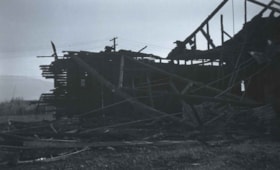
Chicken Hatchery at Royal Oak and Kingsway
https://search.heritageburnaby.ca/link/archivedescription37335
- Repository
- City of Burnaby Archives
- Date
- 1935
- Collection/Fonds
- Burnaby Historical Society fonds
- Description Level
- Item
- Physical Description
- 1 photograph : b&w negative ; 6 x 8.5 cm
- Scope and Content
- Photograph of the remnants of a burned building that was a chicken hatchery at Royal Oak and Kingsway.
- Repository
- City of Burnaby Archives
- Date
- 1935
- Collection/Fonds
- Burnaby Historical Society fonds
- Subseries
- Bernard Bellinger subseries
- Physical Description
- 1 photograph : b&w negative ; 6 x 8.5 cm
- Description Level
- Item
- Record No.
- 354-001
- Access Restriction
- No restrictions
- Reproduction Restriction
- No known restrictions
- Accession Number
- BHS1997-13
- Scope and Content
- Photograph of the remnants of a burned building that was a chicken hatchery at Royal Oak and Kingsway.
- Subjects
- Buildings - Agricultural
- Media Type
- Photograph
- Notes
- Title based on contents of photograph.
- Geographic Access
- Royal Oak Avenue
- Kingsway
- Historic Neighbourhood
- Central Park (Historic Neighbourhood)
Images

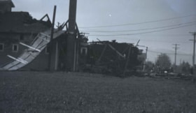
Chicken hatchery at Royal Oak and Kingsway
https://search.heritageburnaby.ca/link/archivedescription37336
- Repository
- City of Burnaby Archives
- Date
- 1935
- Collection/Fonds
- Burnaby Historical Society fonds
- Description Level
- Item
- Physical Description
- 1 photograph : b&w negative ; 6 x 8.5 cm
- Scope and Content
- Photograph of the remnants of a burned building that was a chicken hatchery at Royal Oak and Kingsway.
- Repository
- City of Burnaby Archives
- Date
- 1935
- Collection/Fonds
- Burnaby Historical Society fonds
- Subseries
- Bernard Bellinger subseries
- Physical Description
- 1 photograph : b&w negative ; 6 x 8.5 cm
- Description Level
- Item
- Record No.
- 354-002
- Access Restriction
- No restrictions
- Reproduction Restriction
- No known restrictions
- Accession Number
- BHS1997-13
- Scope and Content
- Photograph of the remnants of a burned building that was a chicken hatchery at Royal Oak and Kingsway.
- Subjects
- Buildings - Agricultural
- Media Type
- Photograph
- Notes
- Title based on contents of photograph.
- Geographic Access
- Royal Oak Avenue
- Kingsway
- Historic Neighbourhood
- Central Park (Historic Neighbourhood)
Images
