More like 'Government Road'
Narrow Results By
Subject
- Advertising Medium - Signs and Signboards 1
- Aerial Photographs 16
- Agricultural Tools and Equipment 1
- Animals 1
- Animals - Birds 1
- Animals - Dogs 1
- Building Components 1
- Buildings - Commercial - Malls 1
- Buildings - Commercial - Restaurants 1
- Buildings - Commercial - Stores 1
- Buildings - Heritage 2
- Buildings - Recreational 1
![Lougheed Drive-In Theatre storm damage, [1962] (date of original), copied 1991 thumbnail](/media/hpo/_Data/_Archives_Images/_Unrestricted/370/370-471.jpg?width=280)
Lougheed Drive-In Theatre storm damage
https://search.heritageburnaby.ca/link/archivedescription37883
- Repository
- City of Burnaby Archives
- Date
- [1962] (date of original), copied 1991
- Collection/Fonds
- Burnaby Historical Society fonds
- Description Level
- Item
- Physical Description
- 1 photograph : b&w ; 3.0 x 2.9 cm print on contact sheet 20.1 x 26.7 cm
- Scope and Content
- Photograph of damage caused by Typhoon "Freda" on October 12, 1962 to the fence at the Lougheed Drive-In Theatre on the 4200 block of Lougheed Highway at Gilmore Avenue. This photograph was taken looking down Lougheed Highway.
- Repository
- City of Burnaby Archives
- Date
- [1962] (date of original), copied 1991
- Collection/Fonds
- Burnaby Historical Society fonds
- Subseries
- Burnaby Image Bank subseries
- Physical Description
- 1 photograph : b&w ; 3.0 x 2.9 cm print on contact sheet 20.1 x 26.7 cm
- Description Level
- Item
- Record No.
- 370-471
- Access Restriction
- No restrictions
- Reproduction Restriction
- No restrictions
- Accession Number
- BHS1999-03
- Scope and Content
- Photograph of damage caused by Typhoon "Freda" on October 12, 1962 to the fence at the Lougheed Drive-In Theatre on the 4200 block of Lougheed Highway at Gilmore Avenue. This photograph was taken looking down Lougheed Highway.
- Media Type
- Photograph
- Notes
- Title based on contents of photograph
- 1 b&w copy negative accompanying
- Negative has a pink cast
- Geographic Access
- Lougheed Highway
- Historic Neighbourhood
- Broadview (Historic Neighbourhood)
- Planning Study Area
- West Central Valley Area
Images
![Lougheed Drive-In Theatre storm damage, [1962] (date of original), copied 1991 thumbnail](/media/hpo/_Data/_Archives_Images/_Unrestricted/370/370-471.jpg)
![Kingsway and Central Park, [196-] thumbnail](/media/hpo/_Data/_Archives_Images/_Unrestricted/001/083-001.jpg?width=280)
Kingsway and Central Park
https://search.heritageburnaby.ca/link/archivedescription34658
- Repository
- City of Burnaby Archives
- Date
- [196-]
- Collection/Fonds
- Burnaby Historical Society fonds
- Description Level
- Item
- Physical Description
- 1 photograph : b&w ; 14.5 x 19.4 cm
- Scope and Content
- Aerial photograph of Kingsway and Central Park.
- Repository
- City of Burnaby Archives
- Date
- [196-]
- Collection/Fonds
- Burnaby Historical Society fonds
- Subseries
- Photographs subseries
- Physical Description
- 1 photograph : b&w ; 14.5 x 19.4 cm
- Description Level
- Item
- Record No.
- 083-001
- Access Restriction
- No restrictions
- Reproduction Restriction
- Reproduce for fair dealing purposes only
- Accession Number
- BHS2007-04
- Scope and Content
- Aerial photograph of Kingsway and Central Park.
- Media Type
- Photograph
- Notes
- Title based on contents of photograph
- Geographic Access
- Kingsway
- Central Park
- Historic Neighbourhood
- Central Park (Historic Neighbourhood)
- Planning Study Area
- Maywood Area
Images
![Kingsway and Central Park, [196-] thumbnail](/media/hpo/_Data/_Archives_Images/_Unrestricted/001/083-001.jpg)

Madelaine Anderson
https://search.heritageburnaby.ca/link/archivedescription37452
- Repository
- City of Burnaby Archives
- Date
- 1963 (date of original), copied 1991
- Collection/Fonds
- Burnaby Historical Society fonds
- Description Level
- Item
- Physical Description
- 1 photograph : b&w ; 3.2 x 3.2 cm print on contact sheet 20.2 x 25.4 cm
- Scope and Content
- Photograph of Madelaine Anderson at the back of her home at 3908 Norland Avenue (previously numbered 4437 Norland Avenue), facing northwest. The Sprott overpass over the Trans Canada Highway can be seen under construction in the background.
- Repository
- City of Burnaby Archives
- Date
- 1963 (date of original), copied 1991
- Collection/Fonds
- Burnaby Historical Society fonds
- Subseries
- Burnaby Image Bank subseries
- Physical Description
- 1 photograph : b&w ; 3.2 x 3.2 cm print on contact sheet 20.2 x 25.4 cm
- Description Level
- Item
- Record No.
- 370-040
- Access Restriction
- No restrictions
- Reproduction Restriction
- No restrictions
- Accession Number
- BHS1999-03
- Scope and Content
- Photograph of Madelaine Anderson at the back of her home at 3908 Norland Avenue (previously numbered 4437 Norland Avenue), facing northwest. The Sprott overpass over the Trans Canada Highway can be seen under construction in the background.
- Media Type
- Photograph
- Notes
- Title based on contents of photograph
- 1 b&w copy negative accompanying
- Photo is missing pieces at centre and bottom left
- Geographic Access
- Norland Avenue
- Street Address
- 3908 Norland Avenue
- Historic Neighbourhood
- Burnaby Lake (Historic Neighbourhood)
- Planning Study Area
- Douglas-Gilpin Area
Images


Interview with Judy Hagen by Eric Damer November 7, 2012 - Track 6
https://search.heritageburnaby.ca/link/oralhistory337
- Repository
- City of Burnaby Archives
- Date Range
- 1944-2012
- Length
- 0:12:18
- Summary
- This portion of the recording pertains to Judith "Judy" (Robins) Hagen's memories of taking dance lessons and being in Girl Guides. She tells a story of seeing the Second Narrows Bridge collapse in 1958.
- Repository
- City of Burnaby Archives
- Summary
- This portion of the recording pertains to Judith "Judy" (Robins) Hagen's memories of taking dance lessons and being in Girl Guides. She tells a story of seeing the Second Narrows Bridge collapse in 1958.
- Date Range
- 1944-2012
- Photo Info
- Judith "Judy" Robins (later Hagen) posing in a dance costume, 1949. Item no. 549-036.
- Length
- 0:12:18
- Interviewer
- Damer, Eric
- Interview Date
- November 7, 2012
- Scope and Content
- Recording is an interview with Judith "Judy" (Robins) Hagen conducted by Burnaby Village Museum employee Eric Damer, November 7, 2012. Major theme discussed: the neighbourhood of Dover Street.
- Biographical Notes
- Judy Robins (later Hagen) was born in 1941 and grew up in South Burnaby. Her paternal grandfather, a master stone mason from Devon, moved to Vancouver in 1912 to find work before bringing over the rest of the family. He bought three lots in Burnaby and in 1918 moved his family to a small house on Dover Street (formerly Paul Street). Judy’s father, Jack, married, bought one of his father’s lots and built a new home for his family. Judy attended school and church nearby, took dance and piano lessons and participated actively in Girl Guides. After high school, she attended the University of British Columbia (UBC) and then Simon Fraser University (SFU), worked for a few years and then married in 1967 before moving to Courtaney, British Columbia.
- Total Tracks
- 7
- Total Length
- 1:09:51
- Interviewee Name
- Hagen, Judith "Judy" Robins
- Interview Location
- Nanaimo Museum on Vancouver Island
- Interviewer Bio
- Eric Damer is a lifelong British Columbian born in Victoria, raised in Kamloops, and currently residing in Burnaby. After studying philosophy at the University of Victoria, he became interested in the educational forces that had shaped his own life. He completed master’s and doctoral degrees in educational studies at the University of British Columbia with a particular interest in the history of adult and higher education in the province. In 2012, Eric worked for the City of Burnaby as a field researcher and writer, conducting interviews for the City Archives and Museum Oral History Program.
- Collection/Fonds
- Community Heritage Commission Special Projects fonds
- Transcript Available
- None
- Media Type
- Sound Recording
Images

Audio Tracks
Track six of recording of interview with Judy Hagen
Track six of recording of interview with Judy Hagen
https://search.heritageburnaby.ca/media/hpo/_Data/_Archives_Oral_Histories/_Unrestricted/MSS171-011/MSS171-011_Track_6.mp3![300 block of Esmonds, [between 1965 and 1970] thumbnail](/media/hpo/_Data/_Archives_Images/_Unrestricted/316/366-017.jpg?width=280)
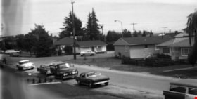
300 block of Esmonds
https://search.heritageburnaby.ca/link/archivedescription37388
- Repository
- City of Burnaby Archives
- Date
- [between 1965 and 1970]
- Collection/Fonds
- Burnaby Historical Society fonds
- Description Level
- Item
- Physical Description
- 1 photograph : b&w negative
- Scope and Content
- Photograph taken looking south along the 300 block of Esmonds Avenue.
- Repository
- City of Burnaby Archives
- Date
- [between 1965 and 1970]
- Collection/Fonds
- Burnaby Historical Society fonds
- Subseries
- Municipal record subseries
- Physical Description
- 1 photograph : b&w negative
- Description Level
- Item
- Record No.
- 366-017
- Access Restriction
- No restrictions
- Reproduction Restriction
- Reproduce for fair dealing purposes only
- Accession Number
- BHS1998-12
- Scope and Content
- Photograph taken looking south along the 300 block of Esmonds Avenue.
- Subjects
- Geographic Features - Roads
- Media Type
- Photograph
- Notes
- Title based on contents of photograph
- Geographic Access
- Esmond Avenue
- Historic Neighbourhood
- Vancouver Heights (Historic Neighbourhood)
- Planning Study Area
- Burnaby Heights Area
Images
![300 block of Esmonds, [between 1965 and 1970] thumbnail](/media/hpo/_Data/_Archives_Images/_Unrestricted/316/366-017.jpg)
![3900 Albert Street, [between 1965 and 1970] thumbnail](/media/hpo/_Data/_Archives_Images/_Unrestricted/316/366-018.jpg?width=280)
3900 Albert Street
https://search.heritageburnaby.ca/link/archivedescription37389
- Repository
- City of Burnaby Archives
- Date
- [between 1965 and 1970]
- Collection/Fonds
- Burnaby Historical Society fonds
- Description Level
- Item
- Physical Description
- 1 photograph : b&w negative
- Scope and Content
- Photograph of the north side of 3900 Albert Street, looking west. The Vancouver Heights Baptist Church can be seen to the far right (at the corner of Albert Street and Ingleton Avenue).
- Repository
- City of Burnaby Archives
- Date
- [between 1965 and 1970]
- Collection/Fonds
- Burnaby Historical Society fonds
- Subseries
- Municipal record subseries
- Physical Description
- 1 photograph : b&w negative
- Description Level
- Item
- Record No.
- 366-018
- Access Restriction
- No restrictions
- Reproduction Restriction
- Reproduce for fair dealing purposes only
- Accession Number
- BHS1998-12
- Scope and Content
- Photograph of the north side of 3900 Albert Street, looking west. The Vancouver Heights Baptist Church can be seen to the far right (at the corner of Albert Street and Ingleton Avenue).
- Media Type
- Photograph
- Notes
- Title based on contents of photograph
- Geographic Access
- Ingleton Avenue
- Albert Street
- Street Address
- 3900 Albert Street
- 271 Ingleton Avenue
- 3977 Albert Street
- Historic Neighbourhood
- Vancouver Heights (Historic Neighbourhood)
- Planning Study Area
- Burnaby Heights Area
Images
![3900 Albert Street, [between 1965 and 1970] thumbnail](/media/hpo/_Data/_Archives_Images/_Unrestricted/316/366-018.jpg)
![3900 Albert Street at Ingleton Avenue, [between 1965 and 1970] thumbnail](/media/hpo/_Data/_Archives_Images/_Unrestricted/316/366-019.jpg?width=280)
3900 Albert Street at Ingleton Avenue
https://search.heritageburnaby.ca/link/archivedescription37390
- Repository
- City of Burnaby Archives
- Date
- [between 1965 and 1970]
- Collection/Fonds
- Burnaby Historical Society fonds
- Description Level
- Item
- Physical Description
- 1 photograph : b&w negative
- Scope and Content
- Photograph looking west along the north side of Albert Street from the 3900 Block. At the far right can be seen the Vancouver Heights Baptist Church, at the intersection of Albert and Ingleton Avenue.
- Repository
- City of Burnaby Archives
- Date
- [between 1965 and 1970]
- Collection/Fonds
- Burnaby Historical Society fonds
- Subseries
- Municipal record subseries
- Physical Description
- 1 photograph : b&w negative
- Description Level
- Item
- Record No.
- 366-019
- Access Restriction
- No restrictions
- Reproduction Restriction
- Reproduce for fair dealing purposes only
- Accession Number
- BHS1998-12
- Scope and Content
- Photograph looking west along the north side of Albert Street from the 3900 Block. At the far right can be seen the Vancouver Heights Baptist Church, at the intersection of Albert and Ingleton Avenue.
- Media Type
- Photograph
- Notes
- Title based on contents of photograph.
- Geographic Access
- Albert Street
- Ingleton Avenue
- Street Address
- 3900 Albert Street
- 271 Ingleton Avenue
- Historic Neighbourhood
- Vancouver Heights (Historic Neighbourhood)
- Planning Study Area
- Burnaby Heights Area
Images
![3900 Albert Street at Ingleton Avenue, [between 1965 and 1970] thumbnail](/media/hpo/_Data/_Archives_Images/_Unrestricted/316/366-019.jpg)
![3900 Hastings Street, [between 1965 and 1970] thumbnail](/media/hpo/_Data/_Archives_Images/_Unrestricted/316/366-010.jpg?width=280)
3900 Hastings Street
https://search.heritageburnaby.ca/link/archivedescription37381
- Repository
- City of Burnaby Archives
- Date
- [between 1965 and 1970]
- Collection/Fonds
- Burnaby Historical Society fonds
- Description Level
- Item
- Physical Description
- 1 photograph : b&w negative
- Scope and Content
- Photograph taken looking west along Hastings Street, in front of the 3900 Block.
- Repository
- City of Burnaby Archives
- Date
- [between 1965 and 1970]
- Collection/Fonds
- Burnaby Historical Society fonds
- Subseries
- Municipal record subseries
- Physical Description
- 1 photograph : b&w negative
- Description Level
- Item
- Record No.
- 366-010
- Access Restriction
- No restrictions
- Reproduction Restriction
- Reproduce for fair dealing purposes only
- Accession Number
- BHS1998-12
- Scope and Content
- Photograph taken looking west along Hastings Street, in front of the 3900 Block.
- Media Type
- Photograph
- Notes
- Title based on contents of photograph
- Geographic Access
- Hastings Street
- Historic Neighbourhood
- Vancouver Heights (Historic Neighbourhood)
- Planning Study Area
- Burnaby Heights Area
Images
![3900 Hastings Street, [between 1965 and 1970] thumbnail](/media/hpo/_Data/_Archives_Images/_Unrestricted/316/366-010.jpg)

Central Mortgage and Housing Co. photographs
https://search.heritageburnaby.ca/link/archivedescription64875
- Repository
- City of Burnaby Archives
- Date
- 1967
- Collection/Fonds
- Burnaby Historical Society fonds
- Description Level
- File
- Physical Description
- 3 photographs : b&w ; 20.5 x 25.5 cm
- Scope and Content
- Photographs of Hastings Street, Burnaby produced by the Central Mortgage and Housing Corporation.
- Repository
- City of Burnaby Archives
- Date
- 1967
- Collection/Fonds
- Burnaby Historical Society fonds
- Subseries
- Photographs subseries
- Physical Description
- 3 photographs : b&w ; 20.5 x 25.5 cm
- Description Level
- File
- Record No.
- 518-001
- Access Restriction
- No restrictions
- Reproduction Restriction
- Reproduce for fair dealing purposes only
- Accession Number
- BHS1993-05
- Scope and Content
- Photographs of Hastings Street, Burnaby produced by the Central Mortgage and Housing Corporation.
- Subjects
- Geographic Features - Roads
- Media Type
- Photograph
- Photographer
- Central Mortgage and Housing Corporation
- Notes
- Title based on contents of file
- Stamp on verso of 518-001 reads: "Please credit Central Mortgage & Housing Corporation Photo 067 627"
- Stamp on verso of 518-001 reads: "Please credit Central Mortgage & Housing Corporation Photo 067 625"
- Stamp on verso of 518-001 reads: "Please credit Central Mortgage & Housing Corporation Photo 067 628"
- Geographic Access
- Hastings Street
Images


Hastings Street
https://search.heritageburnaby.ca/link/archivedescription51467
- Repository
- City of Burnaby Archives
- Date
- 1968
- Collection/Fonds
- Harold H. Johnston fonds
- Description Level
- Item
- Physical Description
- 1 photograph (jpeg) : b&w
- Scope and Content
- Photograph taken looking east along Hastings Street, near Gilmore Avenue. The photograph was taken at night and a number of businesses and business signs are visible, including those for Wosk's and the Admiral Hotel (at 4125 Hastings).
- Repository
- City of Burnaby Archives
- Date
- 1968
- Collection/Fonds
- Harold H. Johnston fonds
- Physical Description
- 1 photograph (jpeg) : b&w
- Description Level
- Item
- Record No.
- 483-068
- Access Restriction
- No restrictions
- Reproduction Restriction
- No reproduction permitted
- Accession Number
- 2008-08
- Scope and Content
- Photograph taken looking east along Hastings Street, near Gilmore Avenue. The photograph was taken at night and a number of businesses and business signs are visible, including those for Wosk's and the Admiral Hotel (at 4125 Hastings).
- Names
- Admiral Hotel
- Media Type
- Photograph
- Photographer
- Johnston, Harold H.
- Notes
- Title based on contents of photograph
- Geographic Access
- Hastings Street
- Street Address
- 4125 Hastings Street
- Historic Neighbourhood
- Vancouver Heights (Historic Neighbourhood)
- Planning Study Area
- Burnaby Heights Area
Images

![Houses at the south side of 3900 Albert Street, [1965] thumbnail](/media/hpo/_Data/_Archives_Images/_Unrestricted/316/366-023.jpg?width=280)
Houses at the south side of 3900 Albert Street
https://search.heritageburnaby.ca/link/archivedescription37394
- Repository
- City of Burnaby Archives
- Date
- [1965]
- Collection/Fonds
- Burnaby Historical Society fonds
- Description Level
- Item
- Physical Description
- 1 photograph : b&w negative
- Scope and Content
- Photograph taken looking east along the south side of 3900 Albert Street.
- Repository
- City of Burnaby Archives
- Date
- [1965]
- Collection/Fonds
- Burnaby Historical Society fonds
- Subseries
- Municipal record subseries
- Physical Description
- 1 photograph : b&w negative
- Description Level
- Item
- Record No.
- 366-023
- Access Restriction
- No restrictions
- Reproduction Restriction
- Reproduce for fair dealing purposes only
- Accession Number
- BHS1998-12
- Scope and Content
- Photograph taken looking east along the south side of 3900 Albert Street.
- Media Type
- Photograph
- Notes
- Title based on contents of photograph.
- Geographic Access
- Albert Street
- Street Address
- 3900 Albert Street
- Historic Neighbourhood
- Vancouver Heights (Historic Neighbourhood)
- Planning Study Area
- Burnaby Heights Area
Images
![Houses at the south side of 3900 Albert Street, [1965] thumbnail](/media/hpo/_Data/_Archives_Images/_Unrestricted/316/366-023.jpg)

Janet Anderson
https://search.heritageburnaby.ca/link/archivedescription37455
- Repository
- City of Burnaby Archives
- Date
- 1965 (date of original), copied 1991
- Collection/Fonds
- Burnaby Historical Society fonds
- Description Level
- Item
- Physical Description
- 1 photograph : b&w ; 4.0 x 3.7 cm print on contact sheet 20.2 x 25.4 cm
- Scope and Content
- Photograph of Janet Anderson standing behind her family home at 3908 Norland Avenue (previously numbered 4437 Norland Avenue). The photograph was taken facing northwest. The completed Sprott overpass over the Trans Canada Highway can be seen in the background.
- Repository
- City of Burnaby Archives
- Date
- 1965 (date of original), copied 1991
- Collection/Fonds
- Burnaby Historical Society fonds
- Subseries
- Burnaby Image Bank subseries
- Physical Description
- 1 photograph : b&w ; 4.0 x 3.7 cm print on contact sheet 20.2 x 25.4 cm
- Description Level
- Item
- Record No.
- 370-043
- Access Restriction
- No restrictions
- Reproduction Restriction
- No restrictions
- Accession Number
- BHS1999-03
- Scope and Content
- Photograph of Janet Anderson standing behind her family home at 3908 Norland Avenue (previously numbered 4437 Norland Avenue). The photograph was taken facing northwest. The completed Sprott overpass over the Trans Canada Highway can be seen in the background.
- Subjects
- Geographic Features - Roads
- Names
- Anderson, Janet
- Media Type
- Photograph
- Notes
- Title based on contents of photograph
- 1 b&w copy negative accompanying
- Copied from col. photograph
- Geographic Access
- Norland Avenue
- Street Address
- 3908 Norland Avenue
- Historic Neighbourhood
- Burnaby Lake (Historic Neighbourhood)
- Planning Study Area
- Douglas-Gilpin Area
Images

![Residential streets, [196-] thumbnail](/media/hpo/_Data/_Archives_Images/_Unrestricted/316/366-028-10.jpg?width=280)
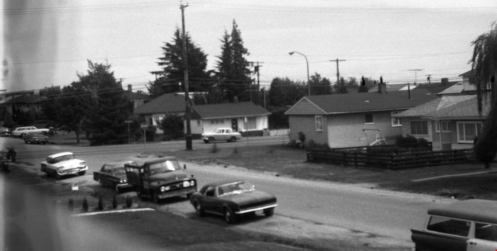
Residential streets
https://search.heritageburnaby.ca/link/archivedescription97613
- Repository
- City of Burnaby Archives
- Date
- [196-]
- Collection/Fonds
- Burnaby Historical Society fonds
- Description Level
- File
- Physical Description
- 22 photographs : b&w negatives
- Scope and Content
- Photographs of various residential streets and houses in North Burnaby. Streets and house numbers are not identified.
- Repository
- City of Burnaby Archives
- Date
- [196-]
- Collection/Fonds
- Burnaby Historical Society fonds
- Subseries
- Municipal record subseries
- Physical Description
- 22 photographs : b&w negatives
- Description Level
- File
- Record No.
- 366-028
- Access Restriction
- No restrictions
- Reproduction Restriction
- Reproduce for fair dealing purposes only
- Accession Number
- BHS1998-12
- Scope and Content
- Photographs of various residential streets and houses in North Burnaby. Streets and house numbers are not identified.
- Media Type
- Photograph
- Notes
- Title based on content of photographs
Images
![Residential streets, [196-] thumbnail](/media/hpo/_Data/_Archives_Images/_Unrestricted/316/366-028-10.jpg)

Snowfall on Venables Street
https://search.heritageburnaby.ca/link/archivedescription51412
- Repository
- City of Burnaby Archives
- Date
- 1966
- Collection/Fonds
- Harold H. Johnston fonds
- Description Level
- Item
- Physical Description
- 1 photograph (jpeg) : b&w
- Scope and Content
- Photograph taken looking out a window onto Venables Street. The street and automobiles parked along it are covered with snow. The photograph was likely taken from the Johnston family home at 4447 Venables Street.
- Repository
- City of Burnaby Archives
- Date
- 1966
- Collection/Fonds
- Harold H. Johnston fonds
- Physical Description
- 1 photograph (jpeg) : b&w
- Description Level
- Item
- Record No.
- 483-046
- Access Restriction
- No restrictions
- Reproduction Restriction
- No reproduction permitted
- Accession Number
- 2008-08
- Scope and Content
- Photograph taken looking out a window onto Venables Street. The street and automobiles parked along it are covered with snow. The photograph was likely taken from the Johnston family home at 4447 Venables Street.
- Media Type
- Photograph
- Photographer
- Johnston, Harold H.
- Notes
- Title based on contents of photograph
- Geographic Access
- Venables Street
- Street Address
- 4447 Venables Street
- Historic Neighbourhood
- Vancouver Heights (Historic Neighbourhood)
- Planning Study Area
- Willingdon Heights Area
Images


Snow on Venables Street
https://search.heritageburnaby.ca/link/archivedescription51403
- Repository
- City of Burnaby Archives
- Date
- 1965
- Collection/Fonds
- Harold H. Johnston fonds
- Description Level
- Item
- Physical Description
- 1 photograph (jpeg) : b&w
- Scope and Content
- Photograph taken looking over the 4400 block of Venables Street. The ground is covered with snow and two children are standing in the front yard of an unidentified house. The photograph was likely taken at the Johnston family home at 4447 Venables Street and the boy to the left is Sean Johnston whi…
- Repository
- City of Burnaby Archives
- Date
- 1965
- Collection/Fonds
- Harold H. Johnston fonds
- Physical Description
- 1 photograph (jpeg) : b&w
- Description Level
- Item
- Record No.
- 483-037
- Access Restriction
- No restrictions
- Reproduction Restriction
- No reproduction permitted
- Accession Number
- 2008-08
- Scope and Content
- Photograph taken looking over the 4400 block of Venables Street. The ground is covered with snow and two children are standing in the front yard of an unidentified house. The photograph was likely taken at the Johnston family home at 4447 Venables Street and the boy to the left is Sean Johnston while the other child is unidentified.
- Names
- Johnston, Dr. Sean
- Media Type
- Photograph
- Photographer
- Johnston, Harold H.
- Notes
- Title based on contents of photograph
- Geographic Access
- Venables Street
- Street Address
- 4447 Venables Street
- Historic Neighbourhood
- Vancouver Heights (Historic Neighbourhood)
- Planning Study Area
- Willingdon Heights Area
Images


Snow on Venables Street
https://search.heritageburnaby.ca/link/archivedescription51404
- Repository
- City of Burnaby Archives
- Date
- 1965
- Collection/Fonds
- Harold H. Johnston fonds
- Description Level
- Item
- Physical Description
- 1 photograph (jpeg) : b&w
- Scope and Content
- Photograph taken looking over the 4400 block of Venables Street after a snowfall. The photograph was likely taken from the home of Harold Johnston at 4447 Venables Street.
- Repository
- City of Burnaby Archives
- Date
- 1965
- Collection/Fonds
- Harold H. Johnston fonds
- Physical Description
- 1 photograph (jpeg) : b&w
- Description Level
- Item
- Record No.
- 483-038
- Access Restriction
- No restrictions
- Reproduction Restriction
- No reproduction permitted
- Accession Number
- 2008-08
- Scope and Content
- Photograph taken looking over the 4400 block of Venables Street after a snowfall. The photograph was likely taken from the home of Harold Johnston at 4447 Venables Street.
- Media Type
- Photograph
- Photographer
- Johnston, Harold H.
- Notes
- Title based on contents of photograph
- Geographic Access
- Venables Street
- Street Address
- 4447 Venables Street
- Historic Neighbourhood
- Vancouver Heights (Historic Neighbourhood)
- Planning Study Area
- Willingdon Heights Area
Images

Venables Street
https://search.heritageburnaby.ca/link/archivedescription51444
- Repository
- City of Burnaby Archives
- Date
- 1967
- Collection/Fonds
- Harold H. Johnston fonds
- Description Level
- Item
- Physical Description
- 1 photograph (jpeg) : b&w
- Scope and Content
- Photograph taken looking along Venables Street. A number of cars and trucks are parked along the street.
- Repository
- City of Burnaby Archives
- Date
- 1967
- Collection/Fonds
- Harold H. Johnston fonds
- Physical Description
- 1 photograph (jpeg) : b&w
- Description Level
- Item
- Record No.
- 483-065
- Access Restriction
- No restrictions
- Reproduction Restriction
- No reproduction permitted
- Accession Number
- 2008-08
- Scope and Content
- Photograph taken looking along Venables Street. A number of cars and trucks are parked along the street.
- Subjects
- Geographic Features - Roads
- Media Type
- Photograph
- Photographer
- Johnston, Harold H.
- Notes
- Title based on contents of photograph
- Geographic Access
- Venables Street
- Historic Neighbourhood
- Vancouver Heights (Historic Neighbourhood)
- Planning Study Area
- Willingdon Heights Area
Images
![Burnaby Mountain, [between 1958 and 1965] (date of original), copied 1991 thumbnail](/media/hpo/_Data/_Archives_Images/_Unrestricted/370/370-797.jpg?width=280)
Burnaby Mountain
https://search.heritageburnaby.ca/link/archivedescription38210
- Repository
- City of Burnaby Archives
- Date
- [between 1958 and 1965] (date of original), copied 1991
- Collection/Fonds
- Burnaby Historical Society fonds
- Description Level
- Item
- Physical Description
- 1 photograph : b&w ; 3.2 x 5.1 cm print on contact sheet 20.5 x 26.8 cm
- Scope and Content
- Aerial photograph of Centennial Park, Burnaby Mountain and Burrard Inlet looking east.
- Repository
- City of Burnaby Archives
- Date
- [between 1958 and 1965] (date of original), copied 1991
- Collection/Fonds
- Burnaby Historical Society fonds
- Subseries
- Burnaby Image Bank subseries
- Physical Description
- 1 photograph : b&w ; 3.2 x 5.1 cm print on contact sheet 20.5 x 26.8 cm
- Description Level
- Item
- Record No.
- 370-797
- Access Restriction
- No restrictions
- Reproduction Restriction
- No restrictions
- Accession Number
- BHS1999-03
- Scope and Content
- Aerial photograph of Centennial Park, Burnaby Mountain and Burrard Inlet looking east.
- Subjects
- Aerial Photographs
- Geographic Features - Inlets
- Geographic Features - Mountains
- Geographic Features - Parks
- Media Type
- Photograph
- Notes
- Title based on contents of photograph
- 1 b&w copy negative accompanying
- Geographic Access
- Burnaby Mountain Conservation Area
- Planning Study Area
- Burnaby Mountain Area
Images
![Burnaby Mountain, [between 1958 and 1965] (date of original), copied 1991 thumbnail](/media/hpo/_Data/_Archives_Images/_Unrestricted/370/370-797.jpg)
![4042 Yale Street, [1961 or 1962] (date of original), copied 1991 thumbnail](/media/hpo/_Data/_Archives_Images/_Unrestricted/370/370-214.jpg?width=280)
4042 Yale Street
https://search.heritageburnaby.ca/link/archivedescription37626
- Repository
- City of Burnaby Archives
- Date
- [1961 or 1962] (date of original), copied 1991
- Collection/Fonds
- Burnaby Historical Society fonds
- Description Level
- Item
- Physical Description
- 1 photograph : b&w ; 3.9 x 3.9 cm print on contact sheet 20.2 x 25.3 cm
- Scope and Content
- Photograph from above 4042 Yale Street looking northeast. Burrard Inlet and the northshore mountains are visible in the background. The photograph was taken during the winter of 1961 to 1962, and there is snow.
- Repository
- City of Burnaby Archives
- Date
- [1961 or 1962] (date of original), copied 1991
- Collection/Fonds
- Burnaby Historical Society fonds
- Subseries
- Burnaby Image Bank subseries
- Physical Description
- 1 photograph : b&w ; 3.9 x 3.9 cm print on contact sheet 20.2 x 25.3 cm
- Description Level
- Item
- Record No.
- 370-214
- Access Restriction
- No restrictions
- Reproduction Restriction
- No restrictions
- Accession Number
- BHS1999-03
- Scope and Content
- Photograph from above 4042 Yale Street looking northeast. Burrard Inlet and the northshore mountains are visible in the background. The photograph was taken during the winter of 1961 to 1962, and there is snow.
- Subjects
- Buildings - Residential - Houses
- Geographic Features - Inlets
- Geographic Features - Mountains
- Media Type
- Photograph
- Notes
- Title based on contents of photograph
- 1 b&w copy negative accompanying
- Geographic Access
- Yale Street
- Street Address
- 4042 Yale Street
- Historic Neighbourhood
- Vancouver Heights (Historic Neighbourhood)
- Planning Study Area
- Burnaby Heights Area
Images
![4042 Yale Street, [1961 or 1962] (date of original), copied 1991 thumbnail](/media/hpo/_Data/_Archives_Images/_Unrestricted/370/370-214.jpg)

Burnaby Lake Show / originals
https://search.heritageburnaby.ca/link/archivedescription91683
- Repository
- City of Burnaby Archives
- Date
- 1962-1995
- Collection/Fonds
- Doreen Lawson fonds
- Description Level
- File
- Physical Description
- 71 photographs : col. slides ; 35 mm
- Scope and Content
- File consists of photographs compiled by Doreen Lawson for a slideshow presentation about Burnaby Lake. Slideshow primarily depicts the wildlife and foliage of Burnaby Lake, including: the American coot, green-winged teal, bufflehead, heron, american bittern, barn swallow, barn owl, painted turtle,…
- Repository
- City of Burnaby Archives
- Date
- 1962-1995
- Collection/Fonds
- Doreen Lawson fonds
- Physical Description
- 71 photographs : col. slides ; 35 mm
- Description Level
- File
- Record No.
- 618-001
- Access Restriction
- No restrictions
- Reproduction Restriction
- May be restricted by third party rights
- Accession Number
- 2015-15
- Scope and Content
- File consists of photographs compiled by Doreen Lawson for a slideshow presentation about Burnaby Lake. Slideshow primarily depicts the wildlife and foliage of Burnaby Lake, including: the American coot, green-winged teal, bufflehead, heron, american bittern, barn swallow, barn owl, painted turtle, muskrat, Canadian goose, beaver, wood duck, bullrushes, yellow and white waterlilies, yellow iris, and loosestrife. Also included in the slideshow are photographs of the BC Wildlife rescue and fisherman working in the Brunette River.
- Subjects
- Geographic Features - Lakes and Ponds
- Animals - Birds
- Animals
- Geographic Features - Forests
- Media Type
- Photograph
- Photographer
- Lawson, Doreen A.
- Chapman, Fred
- Notes
- Transcribed title
- Title transcribed from sheets slides
- Photographs contents are identified on many of the slide cases within the file.
- Historic Neighbourhood
- Burnaby Lake (Historic Neighbourhood)
- Planning Study Area
- Burnaby Lake Area
Images
