More like 'Government Road'
Narrow Results By
![Gaglardi Way pedestrian overpass, [2005] thumbnail](/media/hpo/_Data/_Archives_Images/_Unrestricted/535/535-1858.jpg?width=280)
Gaglardi Way pedestrian overpass
https://search.heritageburnaby.ca/link/archivedescription96161
- Repository
- City of Burnaby Archives
- Date
- [2005]
- Collection/Fonds
- Burnaby NewsLeader photograph collection
- Description Level
- Item
- Physical Description
- 1 photograph (tiff) : col.
- Scope and Content
- Photograph of Alex Nemeth posing next to his truck and the pedestrian overpass on Gaglardi Way.
- Repository
- City of Burnaby Archives
- Date
- [2005]
- Collection/Fonds
- Burnaby NewsLeader photograph collection
- Physical Description
- 1 photograph (tiff) : col.
- Description Level
- Item
- Record No.
- 535-1858
- Access Restriction
- No restrictions
- Reproduction Restriction
- No restrictions
- Accession Number
- 2018-12
- Scope and Content
- Photograph of Alex Nemeth posing next to his truck and the pedestrian overpass on Gaglardi Way.
- Media Type
- Photograph
- Photographer
- Bartel, Mario
- Notes
- Title based on caption
- Collected by editorial for use in a January 2005 issue of the Burnaby NewsLeader
- Caption from metadata: "The windshield on Alex Nemeth's pickup truck was smashed on Tuesday when kids dropped snowballs filled with rocks from the pedestrian overpass on Gagliardi Way in Burnaby as he passed underneath on his way to work. The City of Burnaby has promised to enclose the walkway."
- Geographic Access
- Gaglardi Way
Images
![Gaglardi Way pedestrian overpass, [2005] thumbnail](/media/hpo/_Data/_Archives_Images/_Unrestricted/535/535-1858.jpg)
![Burnaby creek conservationists, [2002] thumbnail](/media/hpo/_Data/_Archives_Images/_Unrestricted/535/535-1959-1.jpg?width=280)
Burnaby creek conservationists
https://search.heritageburnaby.ca/link/archivedescription96276
- Repository
- City of Burnaby Archives
- Date
- [2002]
- Collection/Fonds
- Burnaby NewsLeader photograph collection
- Description Level
- File
- Physical Description
- 4 photographs (tiff) : col.
- Scope and Content
- File contains photographs of volunteer conservationists with the Eagle Creek Streamkeepers, Byrne Creek Streamkeepers, and Sapperton Fish & Game Club at work in the Lake City area by Eagle Creek and the Brunette River. Photographs depict Nick Kvenich, of the Eagle Creek Streamkeepers, in a creek; m…
- Repository
- City of Burnaby Archives
- Date
- [2002]
- Collection/Fonds
- Burnaby NewsLeader photograph collection
- Physical Description
- 4 photographs (tiff) : col.
- Description Level
- File
- Record No.
- 535-1959
- Access Restriction
- No restrictions
- Reproduction Restriction
- No restrictions
- Accession Number
- 2018-12
- Scope and Content
- File contains photographs of volunteer conservationists with the Eagle Creek Streamkeepers, Byrne Creek Streamkeepers, and Sapperton Fish & Game Club at work in the Lake City area by Eagle Creek and the Brunette River. Photographs depict Nick Kvenich, of the Eagle Creek Streamkeepers, in a creek; members of the Byrne Creek Streamkeepers observing a storm drain; and Elmer Rudolf feeding fish at a Sapperton Fish & Game Club hatchery.
- Subjects
- Geographic Features - Creeks
- Geographic Features - Lakes and Ponds
- Geographic Features - Ravines
- Geographic Features - Streams
- Media Type
- Photograph
- Photographer
- Bartel, Mario
- Notes
- Title based on caption
- Collected by editorial for use in a March 2002 issue of the Burnaby NewsLeader
- Caption from metadata for 535-1959-1: "Nick Kvenich is one of the founding members of the Eagle Creek Streamkeepers, which is looking to preserve the habitat of the creek that runs down from Squint Lake into a ravine below the Lake City industrial area."
- Caption from metadata for 535-1959-2: "Joan Carne (r) and Louise Towell, of the Byrne Creek Streamkeepers, examine a storm drain in an industrial area above the creek. The habitat faces constant pressure from businesses and homeowners who pour solvents, soaps and substances into the drains without thought to the consequences."
- Caption from metadata for 535-1959-3: "Nick Kvenich, one of the founding members of the Eagle Creek Streamkeepers, climbs through a fallen tree that is blocking a trail that runs alongside the creek, in a ravine below the Lake City industrial area. Although the tree will eventually be cleared by the GVRD, Kvenich says he prefers if such obstacles be left alone, as they would discourage people who might abuse the habitat."
- Caption from metadata for 535-1959-4: "Elmer Rudolf feeds a new batch of coho fry at the Sapperton Fish & Game Club's hatchery, near the Brunette River. The fry are normally fed by a timed conveyor belt, but that is supplemented by hand feedings to give the weaker fish a chance."
- Geographic Access
- Brunette River
- Eagle Creek
- Planning Study Area
- Lake City Area
Images
![Burnaby creek conservationists, [2002] thumbnail](/media/hpo/_Data/_Archives_Images/_Unrestricted/535/535-1959-1.jpg)
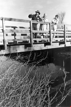
Liz Thurstrom, Bob Gardner, and Ken Elliot
https://search.heritageburnaby.ca/link/archivedescription78731
- Repository
- City of Burnaby Archives
- Date
- December 10, 1995
- Collection/Fonds
- Burnaby NewsLeader photograph collection
- Description Level
- Item
- Physical Description
- 1 photograph : b&w ; 23.5 x 16 cm
- Scope and Content
- Photograph of Liz Thurstrom, of the Wildlife Rescue Association of British Columbia, Bob Gardner, of the Burnaby Lake advisory council and Ken Elliot, of the Greater Vancouver Regional District (GVRD) atop the new footbridge completing the Burnaby Lake Trail.
- Repository
- City of Burnaby Archives
- Date
- December 10, 1995
- Collection/Fonds
- Burnaby NewsLeader photograph collection
- Physical Description
- 1 photograph : b&w ; 23.5 x 16 cm
- Description Level
- Item
- Record No.
- 535-0088
- Access Restriction
- No restrictions
- Reproduction Restriction
- No reproduction permitted
- Accession Number
- 2012-11
- Scope and Content
- Photograph of Liz Thurstrom, of the Wildlife Rescue Association of British Columbia, Bob Gardner, of the Burnaby Lake advisory council and Ken Elliot, of the Greater Vancouver Regional District (GVRD) atop the new footbridge completing the Burnaby Lake Trail.
- Media Type
- Photograph
- Photographer
- Bartel, Mario
- Notes
- Title based on contents of photograph
- Note in black and blue ink on recto of photograph reads: "3454 A Bby Mario / 95% Bby p.1"
- Trim marks and/or reproduction instructions on recto (scan is cropped)
- Geographic Access
- Burnaby Lake
Images

![Byrne Creek Streamkeepers, [2001] thumbnail](/media/hpo/_Data/_Archives_Images/_Unrestricted/535/535-2194-1.jpg?width=280)
Byrne Creek Streamkeepers
https://search.heritageburnaby.ca/link/archivedescription96572
- Repository
- City of Burnaby Archives
- Date
- [2001]
- Collection/Fonds
- Burnaby NewsLeader photograph collection
- Description Level
- File
- Physical Description
- 2 photographs (tiff) : col.
- Scope and Content
- File contains members of the Byrne Creek Streamkeepers during their work to protect the waterways and salmon in the area. Photographs depict Bob Fuller checking a waterflow measuring gauge and Joan Carne standing in the overflow channel at the salmon rearing ponds below Marine Drive.
- Repository
- City of Burnaby Archives
- Date
- [2001]
- Collection/Fonds
- Burnaby NewsLeader photograph collection
- Physical Description
- 2 photographs (tiff) : col.
- Description Level
- File
- Record No.
- 535-2194
- Access Restriction
- No restrictions
- Reproduction Restriction
- No restrictions
- Accession Number
- 2018-12
- Scope and Content
- File contains members of the Byrne Creek Streamkeepers during their work to protect the waterways and salmon in the area. Photographs depict Bob Fuller checking a waterflow measuring gauge and Joan Carne standing in the overflow channel at the salmon rearing ponds below Marine Drive.
- Subjects
- Persons - Volunteers
- Geographic Features - Creeks
- Geographic Features - Lakes and Ponds
- Geographic Features - Streams
- Media Type
- Photograph
- Photographer
- Bartel, Mario
- Notes
- Title based on caption
- Collected by editorial for use in a March 2001 issue of the Burnaby NewsLeader
- Caption from metadata for 535-2194-1: "Bob Fuller, of the Byrne Creek Streamkeepers, checks the guage that measures the flow of water which is released from the holding pond below Marine Drive to the salmon spawning beds downstream."
- Caption from metadata for 535-2194-2: "Joan Carne of the Byrne Creek Streamkeepers stands in the overflow channel at the salmon rearing ponds below Marine Drive. Although last week's chemical spill into Byrne Creek didn't reach the ponds, Carne says it's a constant battle to educate people to take care of the area's creeks and streams."
- Geographic Access
- Marine Drive
- Byrne Creek
- Planning Study Area
- Stride Hill Area
Images
![Byrne Creek Streamkeepers, [2001] thumbnail](/media/hpo/_Data/_Archives_Images/_Unrestricted/535/535-2194-1.jpg)
![Still Creek conservation ceremony, [2001] thumbnail](/media/hpo/_Data/_Archives_Images/_Unrestricted/535/535-1572.jpg?width=280)
Still Creek conservation ceremony
https://search.heritageburnaby.ca/link/archivedescription95714
- Repository
- City of Burnaby Archives
- Date
- [2001]
- Collection/Fonds
- Burnaby NewsLeader photograph collection
- Description Level
- Item
- Physical Description
- 1 photograph (tiff) : col.
- Scope and Content
- Photograph of a member of the Outdoor Recreation Council of BC and Ian Waddell, Minister of the Environment, Lands and Parks, at Still Creek. They stand on a bridge over the water and are looking and gesturing toward something in the distance.
- Repository
- City of Burnaby Archives
- Date
- [2001]
- Collection/Fonds
- Burnaby NewsLeader photograph collection
- Physical Description
- 1 photograph (tiff) : col.
- Description Level
- Item
- Record No.
- 535-1572
- Access Restriction
- No restrictions
- Reproduction Restriction
- No restrictions
- Accession Number
- 2018-12
- Scope and Content
- Photograph of a member of the Outdoor Recreation Council of BC and Ian Waddell, Minister of the Environment, Lands and Parks, at Still Creek. They stand on a bridge over the water and are looking and gesturing toward something in the distance.
- Subjects
- Geographic Features - Creeks
- Geographic Features - Streams
- Officials - Elected Officials
- Events
- Names
- Still Creek
- Media Type
- Photograph
- Photographer
- Bartel, Mario
- Notes
- Title based on caption
- Collected by editorial for use in a January 2001 issue of the Burnaby NewsLeader
- Caption from metadata: "Mark Angelo, of the Outdoor Recreation Council of BC, discusses some of the enhancements that have revived Still Creek with Ian Waddell, the Minister of Environment, Lands and Parks at a ceremony to announce a new 15-30 metre wide protection area on the banks of urban streams."
- Geographic Access
- Still Creek
Images
![Still Creek conservation ceremony, [2001] thumbnail](/media/hpo/_Data/_Archives_Images/_Unrestricted/535/535-1572.jpg)
![David Doyle, [2002] thumbnail](/media/hpo/_Data/_Archives_Images/_Unrestricted/535/535-1981-1.jpg?width=280)
David Doyle
https://search.heritageburnaby.ca/link/archivedescription96298
- Repository
- City of Burnaby Archives
- Date
- [2002]
- Collection/Fonds
- Burnaby NewsLeader photograph collection
- Description Level
- File
- Physical Description
- 2 photographs (tiff) : col.
- Scope and Content
- File contains photographs of David Doyle on Burnaby Mountain. Photographs depict Doyle using a GPS to map streams and watercourses to gather environmental data ahead of the UniverCity development by SFU on Burnaby Mountain.
- Repository
- City of Burnaby Archives
- Date
- [2002]
- Collection/Fonds
- Burnaby NewsLeader photograph collection
- Physical Description
- 2 photographs (tiff) : col.
- Description Level
- File
- Record No.
- 535-1981
- Access Restriction
- No restrictions
- Reproduction Restriction
- No restrictions
- Accession Number
- 2018-12
- Scope and Content
- File contains photographs of David Doyle on Burnaby Mountain. Photographs depict Doyle using a GPS to map streams and watercourses to gather environmental data ahead of the UniverCity development by SFU on Burnaby Mountain.
- Subjects
- Geographic Features - Streams
- Names
- Simon Fraser University
- Media Type
- Photograph
- Photographer
- Bartel, Mario
- Notes
- Title based on caption
- Collected by editorial for use in a February 2002 issue of the Burnaby NewsLeader
- Caption from metadata: "David Doyle uses a satellite Global Positioning System to map streams and watercourses on Burnaby Mountain, in preparation for the Univer-City development around Simon Fraser University. The data he accumulates will be used by the Stoney Creek Environmental Committee to guage the impact construction may have on water quality and fish habitats."
- Geographic Access
- Burnaby Mountain Conservation Area
- Planning Study Area
- Burnaby Mountain Area
Images
![David Doyle, [2002] thumbnail](/media/hpo/_Data/_Archives_Images/_Unrestricted/535/535-1981-1.jpg)
![Dover Street crosswalk lights, [2000] thumbnail](/media/hpo/_Data/_Archives_Images/_Unrestricted/535/535-2540.jpg?width=280)
Dover Street crosswalk lights
https://search.heritageburnaby.ca/link/archivedescription97008
- Repository
- City of Burnaby Archives
- Date
- [2000]
- Collection/Fonds
- Burnaby NewsLeader photograph collection
- Description Level
- Item
- Physical Description
- 1 photograph (tiff) : col.
- Scope and Content
- Photograph of the assistant director of traffic engineering at the City of Burnaby examining a piece of equipment installed in Dover Street as part of a pilot project for new crosswalk lights. A school crosswalk sign and passing vehicle are visible in the background.
- Repository
- City of Burnaby Archives
- Date
- [2000]
- Collection/Fonds
- Burnaby NewsLeader photograph collection
- Physical Description
- 1 photograph (tiff) : col.
- Description Level
- Item
- Record No.
- 535-2540
- Access Restriction
- No restrictions
- Reproduction Restriction
- No restrictions
- Accession Number
- 2018-12
- Scope and Content
- Photograph of the assistant director of traffic engineering at the City of Burnaby examining a piece of equipment installed in Dover Street as part of a pilot project for new crosswalk lights. A school crosswalk sign and passing vehicle are visible in the background.
- Subjects
- Geographic Features - Roads
- Geographic Features - Sidewalks
- Occupations - Civic Workers
- Public Services - Public Works
- Media Type
- Photograph
- Photographer
- Bartel, Mario
- Notes
- Title based on caption
- Collected by editorial for use in a July 2000 issue of the Burnaby NewsLeader
- Caption from metadata: "Burnaby's assistand director of traffic engineering examines the new crosswalk lights, installed as a pilot project, on Dover, between Royal Oak and Nelson."
- Geographic Access
- Dover Street
- Nelson Avenue
- Royal Oak Avenue
- Historic Neighbourhood
- Central Park (Historic Neighbourhood)
- Planning Study Area
- Marlborough Area
Images
![Dover Street crosswalk lights, [2000] thumbnail](/media/hpo/_Data/_Archives_Images/_Unrestricted/535/535-2540.jpg)

Downtown New Westminster
https://search.heritageburnaby.ca/link/archivedescription78687
- Repository
- City of Burnaby Archives
- Date
- November 12, 1995
- Collection/Fonds
- Burnaby NewsLeader photograph collection
- Description Level
- Item
- Physical Description
- 1 photograph : b&w ; 15 x 22 cm
- Scope and Content
- Photograph of a street view of New Westminster's downtown.
- Repository
- City of Burnaby Archives
- Date
- November 12, 1995
- Collection/Fonds
- Burnaby NewsLeader photograph collection
- Physical Description
- 1 photograph : b&w ; 15 x 22 cm
- Description Level
- Item
- Record No.
- 535-0048
- Access Restriction
- No restrictions
- Reproduction Restriction
- No reproduction permitted
- Accession Number
- 2012-11
- Scope and Content
- Photograph of a street view of New Westminster's downtown.
- Media Type
- Photograph
- Photographer
- Bartel, Mario
- Notes
- Title based on contents of photograph
- Note in black ink on recto of photograph reads: "11/12 Bby p.1 118% Mario NW 2941 D"
- Trim marks and/or reproduction instructions on recto (scan is cropped)
Images

![Rob Third and steel pedestrian overpass, [2006] thumbnail](/media/hpo/_Data/_Archives_Images/_Unrestricted/535/535-1902.jpg?width=280)
Rob Third and steel pedestrian overpass
https://search.heritageburnaby.ca/link/archivedescription96210
- Repository
- City of Burnaby Archives
- Date
- [2006]
- Collection/Fonds
- Burnaby NewsLeader photograph collection
- Description Level
- Item
- Physical Description
- 1 photograph (tiff) : col.
- Scope and Content
- Photograph of Rob Third, from steel fabrication plant George Third & Son, posing on the end of a steel pedestrian overpass that he just completed. The overpass will replace a concrete overpass over the Lougheed Highway in Coquitlam.
- Repository
- City of Burnaby Archives
- Date
- [2006]
- Collection/Fonds
- Burnaby NewsLeader photograph collection
- Physical Description
- 1 photograph (tiff) : col.
- Description Level
- Item
- Record No.
- 535-1902
- Access Restriction
- No restrictions
- Reproduction Restriction
- No restrictions
- Accession Number
- 2018-12
- Scope and Content
- Photograph of Rob Third, from steel fabrication plant George Third & Son, posing on the end of a steel pedestrian overpass that he just completed. The overpass will replace a concrete overpass over the Lougheed Highway in Coquitlam.
- Media Type
- Photograph
- Photographer
- Bartel, Mario
- Notes
- Title based on caption
- Collected by editorial for use in a February 2006 issue of the Burnaby NewsLeader
- Caption from metadata: "Rob Third is Burnaby's own Man of Steel. His steel fabrication plant, George Third & Son, has just completed work on a new pedestrian overpass to be installed over the Lougheed Highway in Coquitlam, replacing an old concrete one that was knocked down by a garbage truck last summer."
- Geographic Access
- Trapp Avenue
- Historic Neighbourhood
- Fraser Arm (Historic Neighbourhood)
- Planning Study Area
- Big Bend Area
Images
![Rob Third and steel pedestrian overpass, [2006] thumbnail](/media/hpo/_Data/_Archives_Images/_Unrestricted/535/535-1902.jpg)
![10th Avenue connector construction, [2002] thumbnail](/media/hpo/_Data/_Archives_Images/_Unrestricted/535/535-1984.jpg?width=280)
10th Avenue connector construction
https://search.heritageburnaby.ca/link/archivedescription96301
- Repository
- City of Burnaby Archives
- Date
- [2002]
- Collection/Fonds
- Burnaby NewsLeader photograph collection
- Description Level
- Item
- Physical Description
- 1 photograph (tiff) : col.
- Scope and Content
- Photograph of the view of the new 10th Avenue connector from Gord Thorneycroft's garage. Thorneycroft holds a mug and is silhouetted by the light coming from outside, where the Bombardier SkyTrain plant is visible in the distance.
- Repository
- City of Burnaby Archives
- Date
- [2002]
- Collection/Fonds
- Burnaby NewsLeader photograph collection
- Physical Description
- 1 photograph (tiff) : col.
- Description Level
- Item
- Record No.
- 535-1984
- Access Restriction
- No restrictions
- Reproduction Restriction
- No restrictions
- Accession Number
- 2018-12
- Scope and Content
- Photograph of the view of the new 10th Avenue connector from Gord Thorneycroft's garage. Thorneycroft holds a mug and is silhouetted by the light coming from outside, where the Bombardier SkyTrain plant is visible in the distance.
- Media Type
- Photograph
- Photographer
- Bartel, Mario
- Notes
- Title based on caption
- Collected by editorial for use in a February 2002 issue of the Burnaby NewsLeader
- Caption from metadata: "Gord Thorneycroft says he used to be able to enjoy his morning coffee looking out onto a quiet, tree-lined lane while working in his garage behind his home on 9th Ave. But workers building the new 10th Ave. connector tore out the trees last September, the City of Burnaby isn't making any promises to erect noise barriers, and his lane has become a thoroughfare to the Bombardier Skytrain plant."
- Geographic Access
- 10th Avenue
- Historic Neighbourhood
- Edmonds (Historic Neighbourhood)
- Planning Study Area
- Stride Avenue Area
Images
![10th Avenue connector construction, [2002] thumbnail](/media/hpo/_Data/_Archives_Images/_Unrestricted/535/535-1984.jpg)
![Brantford Elementary school crosswalk, [2004] thumbnail](/media/hpo/_Data/_Archives_Images/_Unrestricted/535/535-2054.jpg?width=280)
Brantford Elementary school crosswalk
https://search.heritageburnaby.ca/link/archivedescription96384
- Repository
- City of Burnaby Archives
- Date
- [2004]
- Collection/Fonds
- Burnaby NewsLeader photograph collection
- Description Level
- Item
- Physical Description
- 1 photograph (tiff) : col.
- Scope and Content
- Photograph of Ernie Kashima, the principal of Brantford Elementary School, standing at a school crosswalk at Sperling Avenue near the elementary school.
- Repository
- City of Burnaby Archives
- Date
- [2004]
- Collection/Fonds
- Burnaby NewsLeader photograph collection
- Physical Description
- 1 photograph (tiff) : col.
- Description Level
- Item
- Record No.
- 535-2054
- Access Restriction
- No restrictions
- Reproduction Restriction
- No restrictions
- Accession Number
- 2018-12
- Scope and Content
- Photograph of Ernie Kashima, the principal of Brantford Elementary School, standing at a school crosswalk at Sperling Avenue near the elementary school.
- Media Type
- Photograph
- Photographer
- Bartel, Mario
- Notes
- Title based on caption
- Collected by editorial for use in a March 2004 issue of the Burnaby NewsLeader
- Caption from metadata: "Ernie Kashima, the principal of Brantford Elementary School, says he pulled his school's student crossing guards from a crossing on Sperling Ave. because of fears for the guards' safety, as the street doesn't have a school speed zone."
- Geographic Access
- Sperling Avenue
- Brantford Avenue
- Street Address
- 6512 Brantford Avenue
- Historic Neighbourhood
- Edmonds (Historic Neighbourhood)
- Planning Study Area
- Kingsway-Beresford Area
Images
![Brantford Elementary school crosswalk, [2004] thumbnail](/media/hpo/_Data/_Archives_Images/_Unrestricted/535/535-2054.jpg)
![Caila Anderson with traffic signs, [2000] thumbnail](/media/hpo/_Data/_Archives_Images/_Unrestricted/535/535-2547.jpg?width=280)
Caila Anderson with traffic signs
https://search.heritageburnaby.ca/link/archivedescription97015
- Repository
- City of Burnaby Archives
- Date
- [2000]
- Collection/Fonds
- Burnaby NewsLeader photograph collection
- Description Level
- Item
- Physical Description
- 1 photograph (tiff) : col.
- Scope and Content
- Photograph of Caila Anderson, an employee of International SPFX, standing with her arms crossed next to two traffic signs on Greenwood Street.
- Repository
- City of Burnaby Archives
- Date
- [2000]
- Collection/Fonds
- Burnaby NewsLeader photograph collection
- Physical Description
- 1 photograph (tiff) : col.
- Description Level
- Item
- Record No.
- 535-2547
- Access Restriction
- No restrictions
- Reproduction Restriction
- No restrictions
- Accession Number
- 2018-12
- Scope and Content
- Photograph of Caila Anderson, an employee of International SPFX, standing with her arms crossed next to two traffic signs on Greenwood Street.
- Subjects
- Planning - City Planning
- Advertising Medium - Signs and Signboards
- Geographic Features - Roads
- Media Type
- Photograph
- Photographer
- Bartel, Mario
- Notes
- Title based on caption
- Collected by editorial for use in a July 2000 issue of the Burnaby NewsLeader
- Caption from metadata: "Caila Anderson, of International SPFX, says new traffic regulations on Greenwood St. have made it really inconvenient for employees at the movie special effects company to get to and from their production offices. Residents on the street say the regulations haven't gone far enough."
- Geographic Access
- Greenwood Street
- Historic Neighbourhood
- Lozells (Historic Neighbourhood)
- Planning Study Area
- Government Road Area
Images
![Caila Anderson with traffic signs, [2000] thumbnail](/media/hpo/_Data/_Archives_Images/_Unrestricted/535/535-2547.jpg)
Derek Corrigan
https://search.heritageburnaby.ca/link/archivedescription80900
- Repository
- City of Burnaby Archives
- Date
- March 15, 1998
- Collection/Fonds
- Burnaby NewsLeader photograph collection
- Description Level
- Item
- Physical Description
- 1 photograph : b&w ; 15.5 x 23.5 cm
- Scope and Content
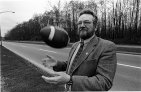
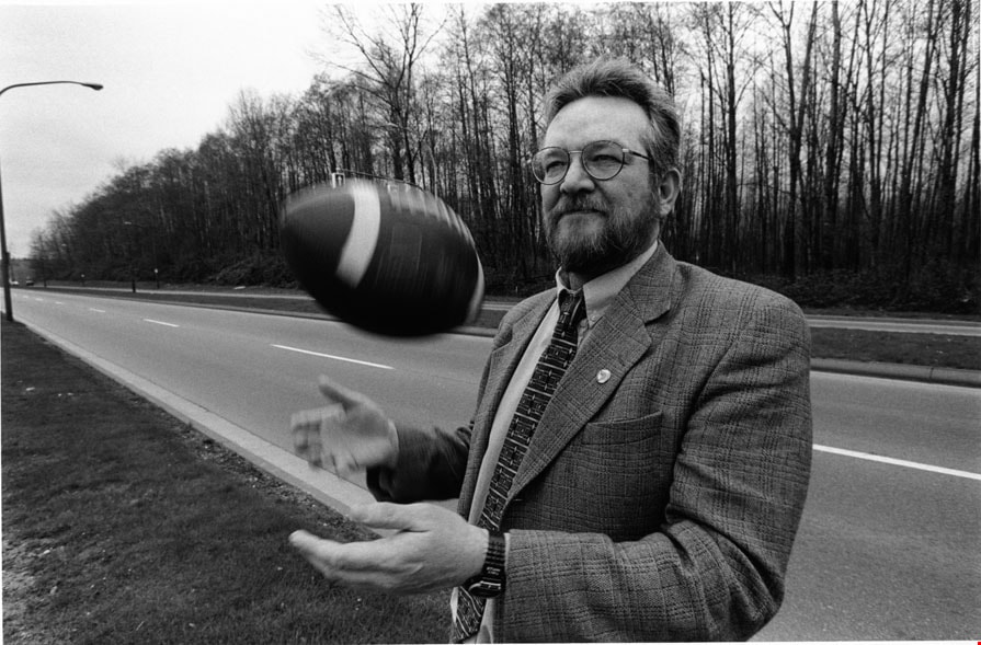
- Photograph of Burnaby Councillor (later mayor) Derek Corrigan tossing a football in the air beside Kensington Avenue.
- Repository
- City of Burnaby Archives
- Date
- March 15, 1998
- Collection/Fonds
- Burnaby NewsLeader photograph collection
- Physical Description
- 1 photograph : b&w ; 15.5 x 23.5 cm
- Description Level
- Item
- Record No.
- 535-1134
- Access Restriction
- No restrictions
- Reproduction Restriction
- No reproduction permitted
- Accession Number
- 2012-11
- Scope and Content
- Photograph of Burnaby Councillor (later mayor) Derek Corrigan tossing a football in the air beside Kensington Avenue.
- Subjects
- Officials - Alderman and Councillors
- Officials - Mayors and Reeves
- Geographic Features - Roads
- Names
- Corrigan, Derek
- Media Type
- Photograph
- Photographer
- Bartel, Mario
- Notes
- Title based on contents of photograph
- Note in blue ink on recto of photograph reads: "537 Bby Mario Bby 3 72%"
- Trim marks and/or reproduction instructions on recto (scan is cropped)
- Accompanying caption reads: "March 15, 1998 537: / Burnaby Councillor Derek Corrigan sees the Burnaby Lake sports complex as the choice for amateur sports groups in BC. The article discusses the $16.9 million outdoor complex to be completed by fall 1999."
Images
![Diana Mumford at school crossing, [2000] thumbnail](/media/hpo/_Data/_Archives_Images/_Unrestricted/535/535-2867.jpg?width=280)
Diana Mumford at school crossing
https://search.heritageburnaby.ca/link/archivedescription97528
- Repository
- City of Burnaby Archives
- Date
- [2000]
- Collection/Fonds
- Burnaby NewsLeader photograph collection
- Description Level
- Item
- Physical Description
- 1 photograph (tiff) : col.
- Scope and Content
- Photograph of Diana Mumford standing on the shoulder of Rumble Street beside a school zone sign, in front of the Suncrest Elementary fences.
- Repository
- City of Burnaby Archives
- Date
- [2000]
- Collection/Fonds
- Burnaby NewsLeader photograph collection
- Physical Description
- 1 photograph (tiff) : col.
- Description Level
- Item
- Record No.
- 535-2867
- Access Restriction
- No restrictions
- Reproduction Restriction
- No restrictions
- Accession Number
- 2018-12
- Scope and Content
- Photograph of Diana Mumford standing on the shoulder of Rumble Street beside a school zone sign, in front of the Suncrest Elementary fences.
- Media Type
- Photograph
- Photographer
- Bartel, Mario
- Notes
- Title based on caption
- Collected by editorial for use in an October 2000 issue of the Burnaby NewsLeader
- Caption from metadata: "Diana Mumford is upset at the lack of sidewalks and safe bus stops along Rumble St. The north side of the street at Suncrest Elementary has speed zone signs, but no sidewalks along which children can safely walk to the school."
- Geographic Access
- Rumble Street
- Street Address
- 3883 Rumble Street
- Historic Neighbourhood
- Alta Vista (Historic Neighbourhood)
- Planning Study Area
- Suncrest Area
Images
![Diana Mumford at school crossing, [2000] thumbnail](/media/hpo/_Data/_Archives_Images/_Unrestricted/535/535-2867.jpg)
![Gaglardi Way motor vehicle accident, [2002] thumbnail](/media/hpo/_Data/_Archives_Images/_Unrestricted/535/535-2918.jpg?width=280)
Gaglardi Way motor vehicle accident
https://search.heritageburnaby.ca/link/archivedescription97602
- Repository
- City of Burnaby Archives
- Date
- [2002]
- Collection/Fonds
- Burnaby NewsLeader photograph collection
- Description Level
- Item
- Physical Description
- 1 photograph (tiff) : col.
- Scope and Content
- Photograph of an overturned truck trailer after a motor vehicle accident at the Gaglardi Way on-ramp to Highway 1. A firefighter is approaching the trailer with a set of pliers and a traffic jam is visible on the highway in the background.
- Repository
- City of Burnaby Archives
- Date
- [2002]
- Collection/Fonds
- Burnaby NewsLeader photograph collection
- Physical Description
- 1 photograph (tiff) : col.
- Description Level
- Item
- Record No.
- 535-2918
- Access Restriction
- No restrictions
- Reproduction Restriction
- No restrictions
- Accession Number
- 2018-12
- Scope and Content
- Photograph of an overturned truck trailer after a motor vehicle accident at the Gaglardi Way on-ramp to Highway 1. A firefighter is approaching the trailer with a set of pliers and a traffic jam is visible on the highway in the background.
- Media Type
- Photograph
- Photographer
- Bartel, Mario
- Notes
- Title based on caption
- Collected by editorial for use in a January 2002 issue of the Burnaby NewsLeader
- Caption from metadata: "Traffic on the eastbound 401 is snarled as Burnaby firefighters clean up liquid amonia spilled when a truck trailer overturned at the Gagliardi on-ramp Thursday morning."
- Geographic Access
- Gaglardi Way
- Planning Study Area
- Burnaby Lake Area
Images
![Gaglardi Way motor vehicle accident, [2002] thumbnail](/media/hpo/_Data/_Archives_Images/_Unrestricted/535/535-2918.jpg)
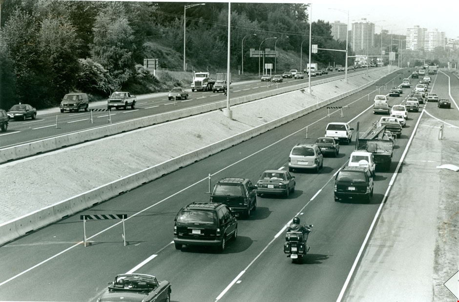
Highway 1
https://search.heritageburnaby.ca/link/archivedescription79313
- Repository
- City of Burnaby Archives
- Date
- July 7, 1996
- Collection/Fonds
- Burnaby NewsLeader photograph collection
- Description Level
- Item
- Physical Description
- 1 photograph : b&w ; 16.5 x 24.5 cm
- Scope and Content
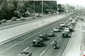
- Photograph of traffic on Highway 1 in Burnaby.
- Repository
- City of Burnaby Archives
- Date
- July 7, 1996
- Collection/Fonds
- Burnaby NewsLeader photograph collection
- Physical Description
- 1 photograph : b&w ; 16.5 x 24.5 cm
- Description Level
- Item
- Record No.
- 535-0341
- Access Restriction
- No restrictions
- Reproduction Restriction
- No reproduction permitted
- Accession Number
- 2012-11
- Scope and Content
- Photograph of traffic on Highway 1 in Burnaby.
- Subjects
- Geographic Features - Roads
- Media Type
- Photograph
- Photographer
- Bartel, Mario
- Notes
- Title based on contents of photograph
- Note in black ink on recto of photograph reads: "1757 Bby Mario / Bby 3 - 50%"
- Trim marks and/or reproduction instructions on recto (scan is cropped)
Images
![New Kingsway and Nelson traffic lights, [2003] thumbnail](/media/hpo/_Data/_Archives_Images/_Unrestricted/535/535-1818.jpg?width=280)
New Kingsway and Nelson traffic lights
https://search.heritageburnaby.ca/link/archivedescription96113
- Repository
- City of Burnaby Archives
- Date
- [2003]
- Collection/Fonds
- Burnaby NewsLeader photograph collection
- Description Level
- Item
- Physical Description
- 1 photograph (tiff) : col.
- Scope and Content
- Photograph of an electrician carrying a new LED traffic light over his head at the intersection of Kingsway and Nelson.
- Repository
- City of Burnaby Archives
- Date
- [2003]
- Collection/Fonds
- Burnaby NewsLeader photograph collection
- Physical Description
- 1 photograph (tiff) : col.
- Description Level
- Item
- Record No.
- 535-1818
- Access Restriction
- No restrictions
- Reproduction Restriction
- No restrictions
- Accession Number
- 2018-12
- Scope and Content
- Photograph of an electrician carrying a new LED traffic light over his head at the intersection of Kingsway and Nelson.
- Subjects
- Construction
- Geographic Features - Roads
- Media Type
- Photograph
- Photographer
- Bartel, Mario
- Notes
- Title based on caption
- Collected by editorial for use in a January 2003 issue of the Burnaby NewsLeader
- Caption from metadata: "Bruce Quigley, of Cobra Electric, carries one of the new LED traffic lights to be installed by his partner, Chongor Lovey, at the corner of Kingsway and Nelson, in Burnaby. The city is replacing the lights at 195 intersections with the new, energy-efficient signals."
- Geographic Access
- Kingsway
- Nelson Avenue
- Historic Neighbourhood
- Central Park (Historic Neighbourhood)
- Planning Study Area
- Maywood Area
Images
![New Kingsway and Nelson traffic lights, [2003] thumbnail](/media/hpo/_Data/_Archives_Images/_Unrestricted/535/535-1818.jpg)
![Rail crossing at Government and Cariboo, [2006] thumbnail](/media/hpo/_Data/_Archives_Images/_Unrestricted/535/535-1880.jpg?width=280)
Rail crossing at Government and Cariboo
https://search.heritageburnaby.ca/link/archivedescription96183
- Repository
- City of Burnaby Archives
- Date
- [2006]
- Collection/Fonds
- Burnaby NewsLeader photograph collection
- Description Level
- Item
- Physical Description
- 1 photograph (tiff) : b&w
- Scope and Content
- Photograph of the rail crossing at the intersection of Government Street and Cariboo Road. Two cars are passing on the road and the opposite directions of traffic are separated by a barrier on the road.
- Repository
- City of Burnaby Archives
- Date
- [2006]
- Collection/Fonds
- Burnaby NewsLeader photograph collection
- Physical Description
- 1 photograph (tiff) : b&w
- Description Level
- Item
- Record No.
- 535-1880
- Access Restriction
- No restrictions
- Reproduction Restriction
- No restrictions
- Accession Number
- 2018-12
- Scope and Content
- Photograph of the rail crossing at the intersection of Government Street and Cariboo Road. Two cars are passing on the road and the opposite directions of traffic are separated by a barrier on the road.
- Media Type
- Photograph
- Photographer
- Bartel, Mario
- Notes
- Title based on caption
- Collected by editorial for use in a January 2006 issue of the Burnaby NewsLeader
- Caption from metadata: "An accident involving a car and a train last summer has prompted the installation of barriers at the rail crossing at Government and Cariboo to prevent cars from jumping the line to beat the crossing arms."
- Geographic Access
- Government Street
- Cariboo Road
- Planning Study Area
- Burnaby Lake Area
Images
![Rail crossing at Government and Cariboo, [2006] thumbnail](/media/hpo/_Data/_Archives_Images/_Unrestricted/535/535-1880.jpg)
![Robert Nasato at Marine/10th Ave. Connector, [2000] thumbnail](/media/hpo/_Data/_Archives_Images/_Unrestricted/535/535-3069.jpg?width=280)
Robert Nasato at Marine/10th Ave. Connector
https://search.heritageburnaby.ca/link/archivedescription97943
- Repository
- City of Burnaby Archives
- Date
- [2000]
- Collection/Fonds
- Burnaby NewsLeader photograph collection
- Description Level
- Item
- Physical Description
- 1 photograph (tiff) : col.
- Scope and Content
- Photograph of Robert Nasato, the president of the West End Residents' Association, posing net to sign advertising the plans for the Marine/10th Ave. Connector.
- Repository
- City of Burnaby Archives
- Date
- [2000]
- Collection/Fonds
- Burnaby NewsLeader photograph collection
- Physical Description
- 1 photograph (tiff) : col.
- Description Level
- Item
- Record No.
- 535-3069
- Access Restriction
- No restrictions
- Reproduction Restriction
- No restrictions
- Accession Number
- 2018-12
- Scope and Content
- Photograph of Robert Nasato, the president of the West End Residents' Association, posing net to sign advertising the plans for the Marine/10th Ave. Connector.
- Media Type
- Photograph
- Photographer
- Bartel, Mario
- Notes
- Title based on caption
- Collected by editorial for use in a January 2000 issue of the Burnaby NewsLeader
- Caption from metadata: "Robert Nasato, the president of the West End Residents' Association, isn't happy about the proposed Marine/10th Ave. connector, to be built through his neighborhood."
- Geographic Access
- 10th Avenue
- Marine Drive
- Historic Neighbourhood
- Fraser Arm (Historic Neighbourhood)
- Planning Study Area
- Stride Hill Area
Images
![Robert Nasato at Marine/10th Ave. Connector, [2000] thumbnail](/media/hpo/_Data/_Archives_Images/_Unrestricted/535/535-3069.jpg)
![Rumble Street school zone signs, [2002] thumbnail](/media/hpo/_Data/_Archives_Images/_Unrestricted/535/535-3018.jpg?width=280)
Rumble Street school zone signs
https://search.heritageburnaby.ca/link/archivedescription97744
- Repository
- City of Burnaby Archives
- Date
- [2002]
- Collection/Fonds
- Burnaby NewsLeader photograph collection
- Description Level
- Item
- Physical Description
- 1 photograph (tiff) : col.
- Scope and Content
- Photograph of City of Burnaby worker Mike Demeda placing a reflective school zone sign on Rumble Street near Suncrest Elementary School. Chris Hildred, Diana Mumfor, and Mark Baxter are watching in the background.
- Repository
- City of Burnaby Archives
- Date
- [2002]
- Collection/Fonds
- Burnaby NewsLeader photograph collection
- Physical Description
- 1 photograph (tiff) : col.
- Description Level
- Item
- Record No.
- 535-3018
- Access Restriction
- No restrictions
- Reproduction Restriction
- No restrictions
- Accession Number
- 2018-12
- Scope and Content
- Photograph of City of Burnaby worker Mike Demeda placing a reflective school zone sign on Rumble Street near Suncrest Elementary School. Chris Hildred, Diana Mumfor, and Mark Baxter are watching in the background.
- Subjects
- Geographic Features - Roads
- Occupations - Civic Workers
- Public Services - Municipal Services
- Media Type
- Photograph
- Photographer
- Bartel, Mario
- Notes
- Title based on caption
- Collected by editorial for use in a November 2002 issue of the Burnaby NewsLeader
- Caption from metadata: "Mike Demeda, of the City of burnaby, places one of the new reflective school zone signs on Rumble St. near Suncrest Elementary. Looking on are Chris Hildred, a volunteer with the SouthWest District, Diana Mumfor, of the traffic and safety committee, and Mark Baxter, of the Burnaby RCMP."
- Geographic Access
- Rumble Street
- Historic Neighbourhood
- Alta Vista (Historic Neighbourhood)
- Planning Study Area
- Suncrest Area
Images
![Rumble Street school zone signs, [2002] thumbnail](/media/hpo/_Data/_Archives_Images/_Unrestricted/535/535-3018.jpg)