More like 'St. Alban's Anglican Church'
Narrow Results By
Decade
- 2020s 96
- 2010s 43
- 2000s 492
- 1990s 421
- 1980s 422
- 1970s 1027
- 1960s 315
- 1950s
- 1940s 483
- 1930s 397
- 1920s 444
- 1910s 492
- 1900s 211
- 1890s 40
- 1880s 56
- 1870s 5
- 1860s 3
- 1850s 3
- 1840s 1
- 1830s 2
- 1820s 1
- 1810s 1
- 1800s 1
- 1790s 1
- 1780s 1
- 1770s 1
- 1760s 1
- 1750s 1
- 1740s 1
- 1730s 1
- 1720s 1
- 1710s 1
- 1700s 1
- 1690s 1
- 1680s 1
- 1670s 1
- 1660s 1
- 1650s 1
- 1640s 1
- 1630s 1
- 1620s 1
- 1610s 1
- 1600s 1
Subject
- Advertising Medium 2
- Advertising Medium - Signs and Signboards 8
- Aerial Photographs 8
- Agriculture - Farms 17
- Agriculture - Fruit and Berries 1
- Animals - Horses 1
- Arts - Paintings 2
- Buildings 2
- Buildings - Agricultural 1
- Buildings - Agricultural - Barns 6
- Buildings - Agricultural - Greenhouses 5
- Buildings - Agricultural - Nurseries 1

Helen 'The Swinging Girl' Neon Sign
https://search.heritageburnaby.ca/link/landmark591
- Repository
- Burnaby Heritage Planning
- Description
- Commercial building.
- Associated Dates
- 1956
- Formal Recognition
- Heritage Designation, Community Heritage Register
- Other Names
- Helen's Childrens Wear Sign
- Street View URL
- Google Maps Street View
- Repository
- Burnaby Heritage Planning
- Other Names
- Helen's Childrens Wear Sign
- Geographic Access
- Hastings Street
- Associated Dates
- 1956
- Formal Recognition
- Heritage Designation, Community Heritage Register
- Enactment Type
- Bylaw No. 12771
- Enactment Date
- 19/04/2010
- Description
- Commercial building.
- Heritage Value
- While the building here is of some importance as the former North Burnaby municipal office, its primary importance is its delightful neon sign that has become a North Burnaby landmark. Helen Arnold opened Helen’s Childrens Wear shop in the building next door to the old Municipal offices in 1948. In 1955, when North Burnaby moved out, she moved into the vacated building. As part of the renovations, Helen enlisted the assistance of her good friend Jimmy Wallace, owner of Vancouver’s Wallace Neon Company, to create a new sign for her expanded business. One of the company’s designers, Reeve Lehman, created the swinging neon girl that was installed in 1956. Designed in two parts, one section of the sign is cloud shaped and reads ‘Helen’s’ while the other section is a moving representation of a little girl on a swing. The sign is nine feet six inches high and nine feet wide, and the lower section is animated with an internal motor and gears. It immediately became a landmark on Hastings Street, and recently the sign’s design fame has spread far and wide as one of the best surviving examples of kinetic neon art in North America.
- Locality
- Vancouver Heights
- Historic Neighbourhood
- Vancouver Heights (Historic Neighbourhood)
- Planning Study Area
- Willingdon Heights Area
- Community
- Burnaby
- Names
- Helen's Childrens Wear
- Street Address
- 4142 Hastings Street
- Street View URL
- Google Maps Street View
Images


The Benedictines of Westminster Priory
https://search.heritageburnaby.ca/link/archivedescription38167
- Repository
- City of Burnaby Archives
- Date
- 1951 (date of original), copied 1991
- Collection/Fonds
- Burnaby Historical Society fonds
- Description Level
- Item
- Physical Description
- 1 photograph : b&w ; 3.3 x 5.3 cm print on contact sheet 20.1 x 26.3 cm
- Scope and Content
- Photograph of an original photographic postcard of the Benedictines of Westminster Priory at Ceperley House which was funded by the Catholic Diocese beginning in 1939. There is a postmark from Merritt, British Columbia, at the top right corner.
- Repository
- City of Burnaby Archives
- Date
- 1951 (date of original), copied 1991
- Collection/Fonds
- Burnaby Historical Society fonds
- Subseries
- Burnaby Image Bank subseries
- Physical Description
- 1 photograph : b&w ; 3.3 x 5.3 cm print on contact sheet 20.1 x 26.3 cm
- Description Level
- Item
- Record No.
- 370-754
- Access Restriction
- No restrictions
- Reproduction Restriction
- No restrictions
- Accession Number
- BHS1999-03
- Scope and Content
- Photograph of an original photographic postcard of the Benedictines of Westminster Priory at Ceperley House which was funded by the Catholic Diocese beginning in 1939. There is a postmark from Merritt, British Columbia, at the top right corner.
- Subjects
- Buildings - Religious
- Buildings - Heritage
- Occupations - Clergy
- Documentary Artifacts - Postcards
- Names
- Westminster Priory
- Media Type
- Photograph
- Notes
- 1 b&w copy negative accompanying
- Negative has a pink cast
- Annotation at bottom of photograph reads, "The Benedictines of Westminster Priory, Vancouver, BC"
- Geographic Access
- Deer Lake Avenue
- Street Address
- 6344 Deer Lake Avenue
- Historic Neighbourhood
- Burnaby Lake (Historic Neighbourhood)
- Planning Study Area
- Douglas-Gilpin Area
Images

![Haida Grill at the Astor Hotel, [between 1955 and 1959] thumbnail](/media/hpo/_Data/_Archives_Images/_Unrestricted/316/327-001.jpg?width=280)
Haida Grill at the Astor Hotel
https://search.heritageburnaby.ca/link/archivedescription37173
- Repository
- City of Burnaby Archives
- Date
- [between 1955 and 1959]
- Collection/Fonds
- Burnaby Historical Society fonds
- Description Level
- Item
- Physical Description
- 1 postcard ; col. ; 8 x 13 cm
- Scope and Content
- Postcard with a photograph of the Haida Grill at the Astor Hotel, which was known as being Burnaby's million dollar, ultra-modern hotel.
- Repository
- City of Burnaby Archives
- Date
- [between 1955 and 1959]
- Collection/Fonds
- Burnaby Historical Society fonds
- Subseries
- Lee Lightfoot subseries
- Physical Description
- 1 postcard ; col. ; 8 x 13 cm
- Description Level
- Item
- Record No.
- 327-001
- Access Restriction
- No restrictions
- Reproduction Restriction
- Reproduce for fair dealing purposes only
- Accession Number
- BHS1996-13
- Scope and Content
- Postcard with a photograph of the Haida Grill at the Astor Hotel, which was known as being Burnaby's million dollar, ultra-modern hotel.
- Subjects
- Buildings - Commercial - Hotels and Motels
- Buildings - Commercial - Restaurants
- Documentary Artifacts - Postcards
- Names
- Astor Hotel
- Media Type
- Photograph
- Notes
- Title based on contents of photograph
- Caption on recto of postcard reads: "ASTOR HOTEL . 4561 KINGSWAY, BURNABY 1, B.C."
- Caption on verso of postcard reads: "THE HAIDA GRILL/ The delightful setting and excellent cuisine makes the Haida Grill a must for dining pleasure. A Photograph [sic] showing the Haida Grill with its table side service."
- Geographic Access
- Kingsway
- Street Address
- 4561 Kingsway
- Historic Neighbourhood
- Central Park (Historic Neighbourhood)
- Planning Study Area
- Marlborough Area
Images
![Haida Grill at the Astor Hotel, [between 1955 and 1959] thumbnail](/media/hpo/_Data/_Archives_Images/_Unrestricted/316/327-001.jpg)
![Greensted Church, [195-] thumbnail](/media/hpo/_Data/_Archives_Images/_Unrestricted/513/514-004.jpg?width=280)
Greensted Church
https://search.heritageburnaby.ca/link/archivedescription64655
- Repository
- City of Burnaby Archives
- Date
- [195-]
- Collection/Fonds
- Ernest Winch fonds
- Description Level
- Item
- Physical Description
- 1 photograph : col. postcard ; 8.5 x 13.5 cm
- Scope and Content
- Photographic postcard of Greensted Church, in the small village of Greensted, near Chipping Ongar in Essex, England, the oldest wooden church in the world (thought to be the oldest wooden building in Europe still standing).
- Repository
- City of Burnaby Archives
- Date
- [195-]
- Collection/Fonds
- Ernest Winch fonds
- Physical Description
- 1 photograph : col. postcard ; 8.5 x 13.5 cm
- Description Level
- Item
- Record No.
- 514-004
- Access Restriction
- No restrictions
- Reproduction Restriction
- Reproduce for fair dealing purposes only
- Accession Number
- 2010-06
- Scope and Content
- Photographic postcard of Greensted Church, in the small village of Greensted, near Chipping Ongar in Essex, England, the oldest wooden church in the world (thought to be the oldest wooden building in Europe still standing).
- Media Type
- Photograph
- Notes
- Title based on contents of photograph
Images
![Greensted Church, [195-] thumbnail](/media/hpo/_Data/_Archives_Images/_Unrestricted/513/514-004.jpg)
![Blue Haven Motel, [195-] thumbnail](/media/hpo/_Data/_Archives_Images/_Unrestricted/126/199-001.jpg?width=280)
Blue Haven Motel
https://search.heritageburnaby.ca/link/archivedescription35136
- Repository
- City of Burnaby Archives
- Date
- [195-]
- Collection/Fonds
- Burnaby Historical Society fonds
- Description Level
- Item
- Physical Description
- 1 photograph : col. postcard ; 8.9 x 13.9 cm
- Scope and Content
- Photographic postcard of the Blue Haven Motel, 7026 Kingsway. The description printed on the back of the postcard reads, "Blue Haven Motel / 7026 Kingsway, South Burnaby, B.C., Canada / Mrgs.: Mr. and Mrs. A. Pearson / 22 Units - 4 Stars - AAA - ACRA / T.V. Equipped / Telephone LA 1-9942." The bui…
- Repository
- City of Burnaby Archives
- Date
- [195-]
- Collection/Fonds
- Burnaby Historical Society fonds
- Subseries
- Photographs subseries
- Physical Description
- 1 photograph : col. postcard ; 8.9 x 13.9 cm
- Description Level
- Item
- Record No.
- 199-001
- Access Restriction
- No restrictions
- Reproduction Restriction
- Reproduce for fair dealing purposes only
- Accession Number
- BHS1987-10
- Scope and Content
- Photographic postcard of the Blue Haven Motel, 7026 Kingsway. The description printed on the back of the postcard reads, "Blue Haven Motel / 7026 Kingsway, South Burnaby, B.C., Canada / Mrgs.: Mr. and Mrs. A. Pearson / 22 Units - 4 Stars - AAA - ACRA / T.V. Equipped / Telephone LA 1-9942." The building on the left side of the photograph has "Office" written on the door. Cars and motel units are seen at the right.
- Names
- Blue Haven Motel
- Media Type
- Photograph
- Responsibility
- Printed on back of postcard: "Traveltime product. Made in Vancouver, Canada, by Grant-Mann Lithographers, Ltd."
- Notes
- Title based on contents of photograph
- Geographic Access
- Kingsway
- Street Address
- 7026 Kingsway
- Historic Neighbourhood
- Edmonds (Historic Neighbourhood)
- Planning Study Area
- Stride Avenue Area
Images
![Blue Haven Motel, [195-] thumbnail](/media/hpo/_Data/_Archives_Images/_Unrestricted/126/199-001.jpg)
![The Fair Haven, [between 1950 and 1957] thumbnail](/media/Hpo/_Data/_Archives_Images/_Unrestricted/251/305-001.jpg?width=280)
The Fair Haven
https://search.heritageburnaby.ca/link/archivedescription36597
- Repository
- City of Burnaby Archives
- Date
- [between 1950 and 1957]
- Collection/Fonds
- Burnaby Historical Society fonds
- Description Level
- Item
- Physical Description
- 1 photograph : col. postcard ; 9 x 14 cm
- Scope and Content
- Aerial photographic postcard of "the Fair Haven," a group of United Church homes for Senior Citizens. The road in the foreground is Rumble Street, and the long road to the right is Sussex Avenue. The small forest behind "the Fair Haven" is the David Gary Park.
- Repository
- City of Burnaby Archives
- Date
- [between 1950 and 1957]
- Collection/Fonds
- Burnaby Historical Society fonds
- Subseries
- Vera Jackson Pel subseries
- Physical Description
- 1 photograph : col. postcard ; 9 x 14 cm
- Description Level
- Item
- Record No.
- 305-001
- Access Restriction
- No restrictions
- Reproduction Restriction
- Reproduce for fair dealing purposes only
- Accession Number
- BHS1992-46
- Scope and Content
- Aerial photographic postcard of "the Fair Haven," a group of United Church homes for Senior Citizens. The road in the foreground is Rumble Street, and the long road to the right is Sussex Avenue. The small forest behind "the Fair Haven" is the David Gary Park.
- Subjects
- Aerial Photographs
- Documentary Artifacts - Postcards
- Buildings - Residential - Seniors Housing
- Names
- Fair Haven
- Media Type
- Photograph
- Notes
- Typewritten note on verso of postcard reads: "AERIAL VIEW/ 'The Fairhaven', Burnaby BC / United Church Homes for Senior Citizens / 4341 Rumble St., Burnaby, BC"
- Handwritten note on verso of postcard reads: ""The road in the foreground is Rumble Street. The long road to the right is Sussex Avenue. The road, going up, on the left, barely visible is McKay Avenue = lower corner. Behind Fair Haven is the future David Gary Park cleared in the late 1950's - then more trees were felled in October 1962 with Hurricane Freda (blown over, uprooted trees) that left the park as it is today in 1993. The top row of little (5) white cottages were moved from the N.W. corner of Willingdon and Kingsway where Old Orchard Mall is now - they were part of Old Orchard Auto Villas, the first Fair Havens. Note: All cottages on right side of Lodge have been moved to Vancouver Island in 1991 for Motel units - by barge."
- Printed on verso of postcard: "Traveltime product, made in Vancouver, Canada, by Grant-Mann Lithographers Ltd."
- Geographic Access
- Rumble Street
- Street Address
- 4341 Rumble Street
- Historic Neighbourhood
- Alta-Vista (Historic Neighbourhood)
- Planning Study Area
- Sussex-Nelson Area
Images
![The Fair Haven, [between 1950 and 1957] thumbnail](/media/Hpo/_Data/_Archives_Images/_Unrestricted/251/305-001.jpg)
![George Derby Health Centre, [between 1950 and 1954] (date of original), copied 1991 thumbnail](/media/hpo/_Data/_Archives_Images/_Unrestricted/370/370-121.jpg?width=280)
George Derby Health Centre
https://search.heritageburnaby.ca/link/archivedescription37533
- Repository
- City of Burnaby Archives
- Date
- [between 1950 and 1954] (date of original), copied 1991
- Collection/Fonds
- Burnaby Historical Society fonds
- Description Level
- Item
- Physical Description
- 1 photograph : b&w ; 2.5 x 4.1 cm print on contact sheet 20.2 x 25.3 cm
- Scope and Content
- Photograph of the George Derby Health Centre which includes the main building, parking lot and grounds.
- Repository
- City of Burnaby Archives
- Date
- [between 1950 and 1954] (date of original), copied 1991
- Collection/Fonds
- Burnaby Historical Society fonds
- Subseries
- Burnaby Image Bank subseries
- Physical Description
- 1 photograph : b&w ; 2.5 x 4.1 cm print on contact sheet 20.2 x 25.3 cm
- Description Level
- Item
- Record No.
- 370-121
- Access Restriction
- No restrictions
- Reproduction Restriction
- No restrictions
- Accession Number
- BHS1999-03
- Scope and Content
- Photograph of the George Derby Health Centre which includes the main building, parking lot and grounds.
- Subjects
- Geographic Features - Automobile Parking Lots
- Buildings - Civic - Hospitals
- Documentary Artifacts - Postcards
- Media Type
- Photograph
- Notes
- Title based on caption on photograph
- 1 b&w copy negative accompanying
- Print was copied from a postcard original
- Caption at bottom of photograph reads, "George Derby Health Centre / Burnaby B.C."
- Geographic Access
- Cumberland Street
- Street Address
- 7550 Cumberland Street
- Historic Neighbourhood
- East Burnaby (Historic Neighbourhood)
- Planning Study Area
- Cariboo-Armstrong Area
Images
![George Derby Health Centre, [between 1950 and 1954] (date of original), copied 1991 thumbnail](/media/hpo/_Data/_Archives_Images/_Unrestricted/370/370-121.jpg)
![George Derby Health Centre, [between 1950 and 1954] (date of original), copied 1991 thumbnail](/media/hpo/_Data/_Archives_Images/_Unrestricted/370/370-127.jpg?width=280)
George Derby Health Centre
https://search.heritageburnaby.ca/link/archivedescription37539
- Repository
- City of Burnaby Archives
- Date
- [between 1950 and 1954] (date of original), copied 1991
- Collection/Fonds
- Burnaby Historical Society fonds
- Description Level
- Item
- Physical Description
- 1 photograph : b&w ; 3.4 x 5.0 cm print on contact sheet 20.2 x 25.3 cm
- Scope and Content
- Aerial photograph of the George Derby Health Centre, copied from a postcard.
- Repository
- City of Burnaby Archives
- Date
- [between 1950 and 1954] (date of original), copied 1991
- Collection/Fonds
- Burnaby Historical Society fonds
- Subseries
- Burnaby Image Bank subseries
- Physical Description
- 1 photograph : b&w ; 3.4 x 5.0 cm print on contact sheet 20.2 x 25.3 cm
- Description Level
- Item
- Record No.
- 370-127
- Access Restriction
- No restrictions
- Reproduction Restriction
- No restrictions
- Accession Number
- BHS1999-03
- Scope and Content
- Aerial photograph of the George Derby Health Centre, copied from a postcard.
- Media Type
- Photograph
- Notes
- Title based on caption on photograph
- 1 b&w copy negative accompanying
- Caption on photograph reads, "George Derby Health Centre, Burnaby B.C."
- Geographic Access
- Cumberland Street
- Street Address
- 7550 Cumberland Street
- Historic Neighbourhood
- East Burnaby (Historic Neighbourhood)
- Planning Study Area
- Cariboo-Armstrong Area
Images
![George Derby Health Centre, [between 1950 and 1954] (date of original), copied 1991 thumbnail](/media/hpo/_Data/_Archives_Images/_Unrestricted/370/370-127.jpg)
![Hotel Burnaby, [1953] thumbnail](/media/hpo/_Data/_Archives_Images/_Unrestricted/371/410-001.jpg?width=280)
Hotel Burnaby
https://search.heritageburnaby.ca/link/archivedescription38341
- Repository
- City of Burnaby Archives
- Date
- [1953]
- Collection/Fonds
- Burnaby Historical Society fonds
- Description Level
- Item
- Physical Description
- 1 photograph : b&w postcard ; 8.7 x 13.1 cm
- Scope and Content
- Photographic postcard advertising the Hotel Burnaby at 1385 Kingsway (old street numbering). A caption on the reverse of the postcard reads: Hotel Burnaby / :Located between new Simpsons-Sears and new Woodwards shopping centres / You will remember Hotel Burnaby for the REST of your life."
- Repository
- City of Burnaby Archives
- Date
- [1953]
- Collection/Fonds
- Burnaby Historical Society fonds
- Subseries
- Jim Wolf subseries
- Physical Description
- 1 photograph : b&w postcard ; 8.7 x 13.1 cm
- Description Level
- Item
- Record No.
- 410-001
- Access Restriction
- No restrictions
- Reproduction Restriction
- Reproduce for fair dealing purposes only
- Accession Number
- BHS2000-11
- Scope and Content
- Photographic postcard advertising the Hotel Burnaby at 1385 Kingsway (old street numbering). A caption on the reverse of the postcard reads: Hotel Burnaby / :Located between new Simpsons-Sears and new Woodwards shopping centres / You will remember Hotel Burnaby for the REST of your life."
- Subjects
- Advertising Medium
- Documentary Artifacts - Postcards
- Buildings - Commercial - Hotels and Motels
- Names
- Hotel Burnaby Limited
- Media Type
- Photograph
- Notes
- Title based on contents of photograph
- Geographic Access
- Kingsway
- Historic Neighbourhood
- Edmonds (Historic Neighbourhood)
- Planning Study Area
- Stride Avenue Area
Images
![Hotel Burnaby, [1953] thumbnail](/media/hpo/_Data/_Archives_Images/_Unrestricted/371/410-001.jpg)
![Hotel Burnaby Ltd., [1955] thumbnail](/media/hpo/_Data/_Archives_Images/_Unrestricted/371/474-001.jpg?width=280)
Hotel Burnaby Ltd.
https://search.heritageburnaby.ca/link/archivedescription38656
- Repository
- City of Burnaby Archives
- Date
- [1955]
- Collection/Fonds
- Burnaby Historical Society fonds
- Description Level
- Item
- Physical Description
- 1 photograph : col. postcard ; 9 x 14 cm
- Scope and Content
- Photographic postcard of Burnaby Hotel located at 1385 Kingsway (old street numbering system). Printed at the bottom of the postcard is the following: Hotel Burnaby Ltd. / 1385 Kingsway at 14th Avenue / Burnaby 3, New Westminster, B.C., Telephone LA 1-8891. On the reverse is written: "Hotel Burna…
- Repository
- City of Burnaby Archives
- Date
- [1955]
- Collection/Fonds
- Burnaby Historical Society fonds
- Subseries
- Jim Wolf subseries
- Physical Description
- 1 photograph : col. postcard ; 9 x 14 cm
- Description Level
- Item
- Record No.
- 474-001
- Access Restriction
- No restrictions
- Reproduction Restriction
- Reproduce for fair dealing purposes only
- Accession Number
- BHS2005-6
- Scope and Content
- Photographic postcard of Burnaby Hotel located at 1385 Kingsway (old street numbering system). Printed at the bottom of the postcard is the following: Hotel Burnaby Ltd. / 1385 Kingsway at 14th Avenue / Burnaby 3, New Westminster, B.C., Telephone LA 1-8891. On the reverse is written: "Hotel Burnaby: Located between new Simpson-Sears and new Woodwards shopping centres. You will remember Hotel Burnaby for the rest of your life."
- Subjects
- Buildings - Commercial - Hotels and Motels
- Documentary Artifacts - Postcards
- Advertising Medium
- Names
- Hotel Burnaby Limited
- Media Type
- Photograph
- Photographer
- Grant-Mann Lithographers Limited
- Notes
- Title based on caption of postcard
- Made by Grant-Mann Lithographers Ltd. "Colour Card" Division, Vancouver British Columbia
- Geographic Access
- Kingsway
- Historic Neighbourhood
- Edmonds (Historic Neighbourhood)
- Planning Study Area
- Stride Avenue Area
Images
![Hotel Burnaby Ltd., [1955] thumbnail](/media/hpo/_Data/_Archives_Images/_Unrestricted/371/474-001.jpg)
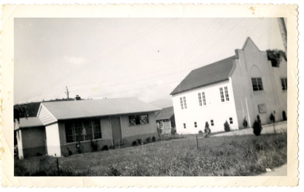
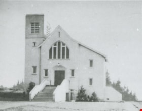
Church and Parsonage
https://search.heritageburnaby.ca/link/archivedescription84880
- Repository
- City of Burnaby Archives
- Date
- 1955
- Collection/Fonds
- Church of Nazarene fonds
- Description Level
- Item
- Physical Description
- 1 photograph : b&w ; 9 x 14.5 cm
- Scope and Content
- Photograph of the Church of Nazarene, church and parsonage buildings located at 577 Clarke Road in Burquitlam. Reverend Garfield James Ferris served as minister of the Church of Nazarene and he lived in the parsonage with his family from 1955 to 1959.
- Repository
- City of Burnaby Archives
- Date
- 1955
- Collection/Fonds
- Church of Nazarene fonds
- Physical Description
- 1 photograph : b&w ; 9 x 14.5 cm
- Description Level
- Item
- Record No.
- 575-001
- Access Restriction
- No restrictions
- Reproduction Restriction
- No restrictions
- Accession Number
- 2014-41
- Scope and Content
- Photograph of the Church of Nazarene, church and parsonage buildings located at 577 Clarke Road in Burquitlam. Reverend Garfield James Ferris served as minister of the Church of Nazarene and he lived in the parsonage with his family from 1955 to 1959.
- Subjects
- Buildings - Religious - Churches
- Media Type
- Photograph
- Notes
- Title based on contents of photograph
- Note in pencil on verso of photograph reads: "Church & Parsonage/ Burquitlam/ New Westminster/ B.C./ 1955"
- Street Address
- 577 Clarke Road
- Historic Neighbourhood
- Burquitlam (Historic Neighbourhood)
Images
![Church of Christ in South Burnaby, [1950] thumbnail](/media/hpo/_Data/_BVM_Images/1985/1985_0006_0001_001.jpg?width=280)
Church of Christ in South Burnaby
https://search.heritageburnaby.ca/link/museumdescription158
- Repository
- Burnaby Village Museum
- Date
- [1950]
- Collection/Fonds
- Burnaby Village Museum Photograph collection
- Description Level
- Item
- Physical Description
- 1 photograph : b&w ; 20.2 x 25.2 cm
- Scope and Content
- Photograph of a large log cabin-style building with a prominent sign above its door that reads, "The Church of Christ / Meets Here." The lot around the building is vacant, and vague outline of a mountain or a hill can be seen in the background. The inscription and the accession register identify …
- Repository
- Burnaby Village Museum
- Collection/Fonds
- Burnaby Village Museum Photograph collection
- Description Level
- Item
- Physical Description
- 1 photograph : b&w ; 20.2 x 25.2 cm
- Scope and Content
- Photograph of a large log cabin-style building with a prominent sign above its door that reads, "The Church of Christ / Meets Here." The lot around the building is vacant, and vague outline of a mountain or a hill can be seen in the background. The inscription and the accession register identify the photograph as Church of Christ in South Burnaby. The annotation on the back of the photo reads: "Church of Christ / South Burnaby / c. 1950."
- Subjects
- Buildings - Religious - Churches
- Names
- Church of Christ
- Accession Code
- BV985.6.1
- Access Restriction
- No restrictions
- Reproduction Restriction
- No known restrictions
- Date
- [1950]
- Media Type
- Photograph
- Scan Resolution
- 600
- Scan Date
- 2023-12-05
- Notes
- Title based on contents of photograph
Images
![Church of Christ in South Burnaby, [1950] thumbnail](/media/hpo/_Data/_BVM_Images/1985/1985_0006_0001_001.jpg)
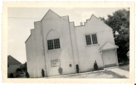
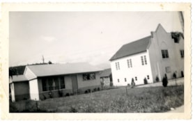
Church of the Nazarene
https://search.heritageburnaby.ca/link/archivedescription88378
- Repository
- City of Burnaby Archives
- Date
- 1955
- Collection/Fonds
- Church of Nazarene fonds
- Description Level
- Item
- Physical Description
- 1 photograph : b&w ; 9 x 14.5 cm
- Scope and Content
- Photograph of the Church of Nazarene located at 577 Clarke Road, Burquitlam. Reverend Garfield James Ferris served as minister of the Church of Nazarene from 1955 to 1959.
- Repository
- City of Burnaby Archives
- Date
- 1955
- Collection/Fonds
- Church of Nazarene fonds
- Physical Description
- 1 photograph : b&w ; 9 x 14.5 cm
- Description Level
- Item
- Record No.
- 575-002
- Access Restriction
- No restrictions
- Reproduction Restriction
- No restrictions
- Accession Number
- 2014-41
- Scope and Content
- Photograph of the Church of Nazarene located at 577 Clarke Road, Burquitlam. Reverend Garfield James Ferris served as minister of the Church of Nazarene from 1955 to 1959.
- Subjects
- Buildings - Religious - Churches
- Media Type
- Photograph
- Notes
- Title based on contents of photograph
- Note in pencil and pen on verso of photograph reads: "Burquitlam church/ 577 Clarke Rd./ BR.7-3969/ duplicate"
- Street Address
- 577 Clarke Road
- Historic Neighbourhood
- Burquitlam (Historic Neighbourhood)
Images

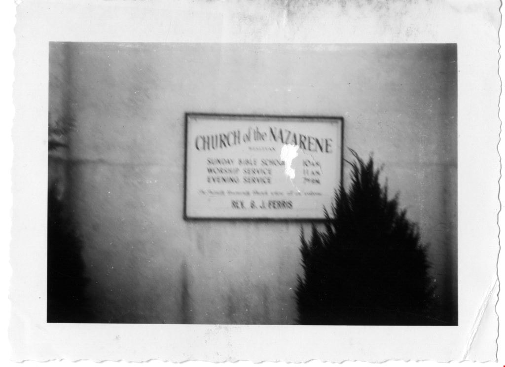
Church of the Nazarene
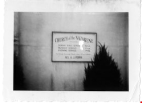
https://search.heritageburnaby.ca/link/archivedescription88386
- Repository
- City of Burnaby Archives
- Date
- June 1958
- Collection/Fonds
- Church of Nazarene fonds
- Description Level
- Item
- Physical Description
- 1 photograph : b&w ; 7 x 9.5 cm
- Scope and Content
- Photograph of the sign in front of the Church of the Nazarene listing the church services.
- Repository
- City of Burnaby Archives
- Date
- June 1958
- Collection/Fonds
- Church of Nazarene fonds
- Physical Description
- 1 photograph : b&w ; 7 x 9.5 cm
- Description Level
- Item
- Record No.
- 575-010
- Access Restriction
- No restrictions
- Reproduction Restriction
- No restrictions
- Accession Number
- 2014-41
- Scope and Content
- Photograph of the sign in front of the Church of the Nazarene listing the church services.
- Subjects
- Buildings - Religious - Churches
- Media Type
- Photograph
- Notes
- Title based on contents of photograph
- Photograph is out of focus
- Stamp on verso of photograph reads: 808
- Street Address
- 577 Clarke Road
- Historic Neighbourhood
- Burquitlam (Historic Neighbourhood)
Images
![Gordon Presbyterian Church, [195-] (date of original), copied 1987 thumbnail](/media/hpo/_Data/_Archives_Images/_Unrestricted/126/193-016.jpg?width=280)
Gordon Presbyterian Church
https://search.heritageburnaby.ca/link/archivedescription35115
- Repository
- City of Burnaby Archives
- Date
- [195-] (date of original), copied 1987
- Collection/Fonds
- Burnaby Historical Society fonds
- Description Level
- Item
- Physical Description
- 1 photograph : b&w ; 8.9 x 12.5 cm print
- Scope and Content
- Photograph of the exterior of the Gordon Presbyterian Church, at 7457 Edmonds Street.
- Repository
- City of Burnaby Archives
- Date
- [195-] (date of original), copied 1987
- Collection/Fonds
- Burnaby Historical Society fonds
- Subseries
- Gordon Presbyterian Church subseries
- Physical Description
- 1 photograph : b&w ; 8.9 x 12.5 cm print
- Description Level
- Item
- Record No.
- 193-016
- Access Restriction
- No restrictions
- Reproduction Restriction
- Reproduce for fair dealing purposes only
- Accession Number
- BHS1987-02
- Scope and Content
- Photograph of the exterior of the Gordon Presbyterian Church, at 7457 Edmonds Street.
- Subjects
- Buildings - Religious - Churches
- Media Type
- Photograph
- Notes
- Title based on contents of photograph
- Geographic Access
- Edmonds Street
- Street Address
- 7457 Edmonds Street
- Historic Neighbourhood
- Edmonds (Historic Neighbourhood)
- Planning Study Area
- Richmond Park Area
Images
![Gordon Presbyterian Church, [195-] (date of original), copied 1987 thumbnail](/media/hpo/_Data/_Archives_Images/_Unrestricted/126/193-016.jpg)
![Gordon Presbyterian Church, [195-] (date of original), copied 1987 thumbnail](/media/hpo/_Data/_Archives_Images/_Unrestricted/126/193-017.jpg?width=280)
Gordon Presbyterian Church
https://search.heritageburnaby.ca/link/archivedescription35116
- Repository
- City of Burnaby Archives
- Date
- [195-] (date of original), copied 1987
- Collection/Fonds
- Burnaby Historical Society fonds
- Description Level
- Item
- Physical Description
- 1 photograph : b&w ; 8.8 x 12.7 cm print
- Scope and Content
- Photograph of the interior of the Gordon Presbyterian Church. The alter, pulpits and pews can be seen. Written on the altar: "In remembrance of me."
- Repository
- City of Burnaby Archives
- Date
- [195-] (date of original), copied 1987
- Collection/Fonds
- Burnaby Historical Society fonds
- Subseries
- Gordon Presbyterian Church subseries
- Physical Description
- 1 photograph : b&w ; 8.8 x 12.7 cm print
- Description Level
- Item
- Record No.
- 193-017
- Access Restriction
- No restrictions
- Reproduction Restriction
- Reproduce for fair dealing purposes only
- Accession Number
- BHS1987-02
- Scope and Content
- Photograph of the interior of the Gordon Presbyterian Church. The alter, pulpits and pews can be seen. Written on the altar: "In remembrance of me."
- Subjects
- Buildings - Religious - Churches
- Media Type
- Photograph
- Notes
- Title based on contents of photograph
- Geographic Access
- Edmonds Street
- Street Address
- 7457 Edmonds Street
- Historic Neighbourhood
- Edmonds (Historic Neighbourhood)
- Planning Study Area
- Richmond Park Area
Images
![Gordon Presbyterian Church, [195-] (date of original), copied 1987 thumbnail](/media/hpo/_Data/_Archives_Images/_Unrestricted/126/193-017.jpg)
![Moving St. Helen's Church, [1955-1956] thumbnail](/media/hpo/_Data/_Archives_Images/_Unrestricted/494/495-003.jpg?width=280)
Moving St. Helen's Church
https://search.heritageburnaby.ca/link/archivedescription58379
- Repository
- City of Burnaby Archives
- Date
- [1955-1956]
- Collection/Fonds
- Sheila Minni fonds
- Description Level
- Item
- Physical Description
- 1 photograph : sepia ; 4.5 x 7 cm
- Scope and Content
- Photograph of a truck moving the St. Helen's Church building. The Church was replaced in 1956 with a new building.
- Repository
- City of Burnaby Archives
- Date
- [1955-1956]
- Collection/Fonds
- Sheila Minni fonds
- Physical Description
- 1 photograph : sepia ; 4.5 x 7 cm
- Description Level
- Item
- Record No.
- 495-003
- Access Restriction
- No restrictions
- Reproduction Restriction
- No known restrictions
- Accession Number
- 2009-04
- Scope and Content
- Photograph of a truck moving the St. Helen's Church building. The Church was replaced in 1956 with a new building.
- Media Type
- Photograph
- Notes
- Title based on contents of photograph
- Geographic Access
- Triumph Street
- Street Address
- 3894 Triumph Street
- Historic Neighbourhood
- Vancouver Heights (Historic Neighbourhood)
- Planning Study Area
- Burnaby Heights Area
Images
![Moving St. Helen's Church, [1955-1956] thumbnail](/media/hpo/_Data/_Archives_Images/_Unrestricted/494/495-003.jpg)
![St. Helen's Church, [1955-1956] thumbnail](/media/hpo/_Data/_Archives_Images/_Unrestricted/494/495-001.jpg?width=280)
St. Helen's Church
https://search.heritageburnaby.ca/link/archivedescription58377
- Repository
- City of Burnaby Archives
- Date
- [1955-1956]
- Collection/Fonds
- Sheila Minni fonds
- Description Level
- Item
- Physical Description
- 1 photograph : sepia ; 4.5 x 7 cm
- Scope and Content
- Photograph of a fire at the manse next to St. Helen's Church. Two children with bicycles can be seen standing near the street corner.
- Repository
- City of Burnaby Archives
- Date
- [1955-1956]
- Collection/Fonds
- Sheila Minni fonds
- Physical Description
- 1 photograph : sepia ; 4.5 x 7 cm
- Description Level
- Item
- Record No.
- 495-001
- Access Restriction
- No restrictions
- Reproduction Restriction
- No known restrictions
- Accession Number
- 2009-04
- Scope and Content
- Photograph of a fire at the manse next to St. Helen's Church. Two children with bicycles can be seen standing near the street corner.
- Subjects
- Buildings - Religious - Churches
- Media Type
- Photograph
- Notes
- Title based on contents of photograph
- Geographic Access
- Triumph Street
- Street Address
- 3894 Triumph Street
- Historic Neighbourhood
- Vancouver Heights (Historic Neighbourhood)
- Planning Study Area
- Burnaby Heights Area
Images
![St. Helen's Church, [1955-1956] thumbnail](/media/hpo/_Data/_Archives_Images/_Unrestricted/494/495-001.jpg)
![St. Helen's Church Steeple, [1955-1956] thumbnail](/media/hpo/_Data/_Archives_Images/_Unrestricted/494/495-002.jpg?width=280)
St. Helen's Church Steeple
https://search.heritageburnaby.ca/link/archivedescription58378
- Repository
- City of Burnaby Archives
- Date
- [1955-1956]
- Collection/Fonds
- Sheila Minni fonds
- Description Level
- Item
- Physical Description
- 1 photograph : sepia ; 4.5 x 7 cm
- Scope and Content
- Photograph of the steeple of St. Helen's Church after it was torn down. The Church was replaced in 1956 when a new building was constructed. Siting inside the steeple are three children: the girl on the right has been identified as Sheila Minni, the boy seated up in the middle of the steeple is B…
- Repository
- City of Burnaby Archives
- Date
- [1955-1956]
- Collection/Fonds
- Sheila Minni fonds
- Physical Description
- 1 photograph : sepia ; 4.5 x 7 cm
- Description Level
- Item
- Record No.
- 495-002
- Access Restriction
- No restrictions
- Reproduction Restriction
- No known restrictions
- Accession Number
- 2009-04
- Scope and Content
- Photograph of the steeple of St. Helen's Church after it was torn down. The Church was replaced in 1956 when a new building was constructed. Siting inside the steeple are three children: the girl on the right has been identified as Sheila Minni, the boy seated up in the middle of the steeple is Bobby Priest and the other girl is known only as Katherine.
- Subjects
- Buildings - Religious - Churches
- Media Type
- Photograph
- Notes
- Title based on contents of photograph
- Geographic Access
- Triumph Street
- Street Address
- 3894 Triumph Street
- Historic Neighbourhood
- Vancouver Heights (Historic Neighbourhood)
- Planning Study Area
- Burnaby Heights Area
Images
![St. Helen's Church Steeple, [1955-1956] thumbnail](/media/hpo/_Data/_Archives_Images/_Unrestricted/494/495-002.jpg)
Willingdon Heights United Church
https://search.heritageburnaby.ca/link/archivedescription37703
- Repository
- City of Burnaby Archives
- Date
- 1952 (date of original), copied 1991
- Collection/Fonds
- Burnaby Historical Society fonds
- Description Level
- Item
- Physical Description
- 1 photograph : b&w ; 3.4 x 4.4 cm print on contact sheet 20.2 x 25.3 cm
- Scope and Content
- Photograph of the exterior of Willingdon Heights United Church at 4304 Parker Street.
- Repository
- City of Burnaby Archives
- Date
- 1952 (date of original), copied 1991
- Collection/Fonds
- Burnaby Historical Society fonds
- Subseries
- Burnaby Image Bank subseries
- Physical Description
- 1 photograph : b&w ; 3.4 x 4.4 cm print on contact sheet 20.2 x 25.3 cm
- Description Level
- Item
- Record No.
- 370-291
- Access Restriction
- No restrictions
- Reproduction Restriction
- No restrictions
- Accession Number
- BHS1999-03
- Scope and Content
- Photograph of the exterior of Willingdon Heights United Church at 4304 Parker Street.
- Subjects
- Buildings - Religious - Churches
- Media Type
- Photograph
- Notes
- Title based on contents of photograph
- 1 b&w copy negative accompanying
- Geographic Access
- Parker Street
- Street Address
- 4304 Parker Street
- Historic Neighbourhood
- Vancouver Heights (Historic Neighbourhood)
- Planning Study Area
- Willingdon Heights Area
Images
