More like 'Lenkurt Electric Company'
Narrow Results By
Subject
- Accidents 1
- Accidents - Automobile Accidents 30
- Accidents - Train Accidents 2
- Advertising Medium 3
- Advertising Medium - Signs and Signboards 125
- Aerial Photographs 131
- Agricultural Tools and Equipment 2
- Agricultural Tools and Equipment - Gardening Equipment 4
- Agricultural Tools and Equipment - Plows 5
- Agriculture 5
- Agriculture - Crops 5
- Agriculture - Farms 59

Burnaby Mountain Parking Lot & Restaurant
https://search.heritageburnaby.ca/link/archivedescription93706
- Repository
- City of Burnaby Archives
- Date
- February 15, 1978
- Collection/Fonds
- Burnaby Public Library Contemporary Visual Archive Project
- Description Level
- Item
- Physical Description
- 1 photograph : b&w ; 12.5 x 17.5 cm
- Scope and Content
- Photograph of the view of the mountains and park from a hill on Burnaby Mountain Park. The photograph is taken facing north. The photograph shows the parking lot and the Burnaby Mountain Centennial Pavilion.
- Repository
- City of Burnaby Archives
- Date
- February 15, 1978
- Collection/Fonds
- Burnaby Public Library Contemporary Visual Archive Project
- Physical Description
- 1 photograph : b&w ; 12.5 x 17.5 cm
- Description Level
- Item
- Record No.
- 556-663
- Access Restriction
- No restrictions
- Reproduction Restriction
- Reproduce for fair dealing purposes only
- Accession Number
- 2017-57
- Scope and Content
- Photograph of the view of the mountains and park from a hill on Burnaby Mountain Park. The photograph is taken facing north. The photograph shows the parking lot and the Burnaby Mountain Centennial Pavilion.
- Subjects
- Buildings - Commercial - Restaurants
- Buildings - Civic
- Buildings - Recreational
- Geographic Features - Automobile Parking Lots
- Geographic Features - Parks
- Names
- Burnaby Mountain Park
- Media Type
- Photograph
- Photographer
- Surridge, Jack
- Notes
- Title taken from project information form
- Accompanied by a project information form and 1 photograph (b&w negative ; 9.5 x 12.5 cm)
- BPL no. 111
- Geographic Access
- Burnaby Lake Regional Nature Park
- Burnaby Mountain Conservation Area
- Street Address
- 100 Centennial Way
- Planning Study Area
- Burnaby Mountain Area
Images


Burnaby Mountain Park Looking West
https://search.heritageburnaby.ca/link/archivedescription93707
- Repository
- City of Burnaby Archives
- Date
- February 15, 1978
- Collection/Fonds
- Burnaby Public Library Contemporary Visual Archive Project
- Description Level
- Item
- Physical Description
- 1 photograph : b&w ; 12.5 x 17.5 cm
- Scope and Content
- Photograph of the view from Burnaby Mountain Park. The photograph is taken facing west and shows the park, part of the parking lot at the Burnaby Centennial Pavilion, and Capitol Hill and the mountains in the distance.
- Repository
- City of Burnaby Archives
- Date
- February 15, 1978
- Collection/Fonds
- Burnaby Public Library Contemporary Visual Archive Project
- Physical Description
- 1 photograph : b&w ; 12.5 x 17.5 cm
- Description Level
- Item
- Record No.
- 556-664
- Access Restriction
- No restrictions
- Reproduction Restriction
- Reproduce for fair dealing purposes only
- Accession Number
- 2017-57
- Scope and Content
- Photograph of the view from Burnaby Mountain Park. The photograph is taken facing west and shows the park, part of the parking lot at the Burnaby Centennial Pavilion, and Capitol Hill and the mountains in the distance.
- Subjects
- Geographic Features - Parks
- Geographic Features - Mountains
- Geographic Features - Automobile Parking Lots
- Names
- Burnaby Mountain Park
- Media Type
- Photograph
- Photographer
- Surridge, Jack
- Notes
- Title taken from project information form
- Accompanied by a project information form and 1 photograph (b&w negative ; 9.5 x 12.5 cm)
- BPL no. 112
- Geographic Access
- Burnaby Mountain Conservation Area
- Street Address
- 100 Centennial Way
- Planning Study Area
- Burnaby Mountain Area
Images


Central Park testing station
https://search.heritageburnaby.ca/link/archivedescription95101
- Repository
- City of Burnaby Archives
- Date
- May 9, 2020
- Collection/Fonds
- Burnaby Photographic Society fonds
- Description Level
- Item
- Physical Description
- 1 photograph (tiff)
- Scope and Content
- Photograph of the COVID-19 testing station located in the Central Park parking lot off Boundary Road. A sign in the foreground reads "Covid-19 Care Site by Referral Only / Walk in Access". In the background, the white tents of the testing station are visible.
- Repository
- City of Burnaby Archives
- Date
- May 9, 2020
- Collection/Fonds
- Burnaby Photographic Society fonds
- Physical Description
- 1 photograph (tiff)
- Description Level
- Item
- Record No.
- 623-019
- Access Restriction
- No restrictions
- Reproduction Restriction
- No restrictions
- Accession Number
- 2020-10
- Scope and Content
- Photograph of the COVID-19 testing station located in the Central Park parking lot off Boundary Road. A sign in the foreground reads "Covid-19 Care Site by Referral Only / Walk in Access". In the background, the white tents of the testing station are visible.
- Subjects
- Geographic Features - Parks
- Geographic Features - Automobile Parking Lots
- Advertising Medium - Signs and Signboards
- Structures - Tents
- Media Type
- Photograph
- Photographer
- Damer, Eric
- Notes
- Transcribed title
- Geographic Access
- Boundary Road
- Central Park
- Historic Neighbourhood
- Central Park (Historic Neighbourhood)
- Planning Study Area
- Maywood Area
Images


Deer Lake parking lot off limits
https://search.heritageburnaby.ca/link/archivedescription95113
- Repository
- City of Burnaby Archives
- Date
- June 26, 2020
- Collection/Fonds
- Burnaby Photographic Society fonds
- Description Level
- Item
- Physical Description
- 1 photograph (tiff)
- Scope and Content
- Photograph of the Deer Lake Park parking lot at the Royal Oak entrance. The entrance to the lot is blocked off with two orange traffic barriers. In the distance, a sign detailing a temporary one-way walking route for the park and a man walking into the park are visible.
- Repository
- City of Burnaby Archives
- Date
- June 26, 2020
- Collection/Fonds
- Burnaby Photographic Society fonds
- Physical Description
- 1 photograph (tiff)
- Description Level
- Item
- Record No.
- 623-031
- Access Restriction
- No restrictions
- Reproduction Restriction
- No restrictions
- Accession Number
- 2020-10
- Scope and Content
- Photograph of the Deer Lake Park parking lot at the Royal Oak entrance. The entrance to the lot is blocked off with two orange traffic barriers. In the distance, a sign detailing a temporary one-way walking route for the park and a man walking into the park are visible.
- Media Type
- Photograph
- Photographer
- Snowdon, Nick
- Notes
- Transcribed title
- Photographer's caption: "Deer Lake parking lots are blocked off for a few months"
- Geographic Access
- Deer Lake Park
- Planning Study Area
- Windsor Area
Images


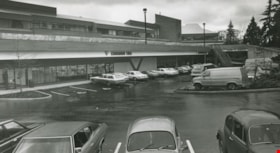
BCIT BCVS Parking Area
https://search.heritageburnaby.ca/link/archivedescription93636
- Repository
- City of Burnaby Archives
- Date
- October 26, 1977
- Collection/Fonds
- Burnaby Public Library Contemporary Visual Archive Project
- Description Level
- Item
- Physical Description
- 1 photograph : b&w ; 12.5 x 17.5 cm
- Scope and Content
- Photograph of the parking lot at the British Columbia Institute of Technology (BCIT) and the British Columbia Vocational School (BCVS) on Wayburne Drive. The parking lot is full of cars and campus buildings are visible in the background. The photograph is taken facing north.
- Repository
- City of Burnaby Archives
- Date
- October 26, 1977
- Collection/Fonds
- Burnaby Public Library Contemporary Visual Archive Project
- Physical Description
- 1 photograph : b&w ; 12.5 x 17.5 cm
- Description Level
- Item
- Record No.
- 556-593
- Access Restriction
- No restrictions
- Reproduction Restriction
- Reproduce for fair dealing purposes only
- Accession Number
- 2017-57
- Scope and Content
- Photograph of the parking lot at the British Columbia Institute of Technology (BCIT) and the British Columbia Vocational School (BCVS) on Wayburne Drive. The parking lot is full of cars and campus buildings are visible in the background. The photograph is taken facing north.
- Subjects
- Geographic Features - Automobile Parking Lots
- Buildings - Schools - Universities and Colleges
- Media Type
- Photograph
- Photographer
- Surridge, Jack
- Notes
- Title taken from project information form
- Accompanied by a project information form and 1 photograph (b&w negative ; 9.5 x 12.5 cm)
- BPL no. 42
- Geographic Access
- Wayburne Drive
- Street Address
- 3700 Willingdon Avenue
- Historic Neighbourhood
- Burnaby Lake (Historic Neighbourhood)
- Planning Study Area
- Douglas-Gilpin Area
Images

![Brentwood Shopping Centre, [196-] thumbnail](/media/hpo/_Data/_Archives_Images/_Unrestricted/126/195-002.jpg?width=280)
Brentwood Shopping Centre
https://search.heritageburnaby.ca/link/archivedescription35132
- Repository
- City of Burnaby Archives
- Date
- [196-]
- Collection/Fonds
- Burnaby Historical Society fonds
- Description Level
- Item
- Physical Description
- 1 photograph : col. postcard ; 8.9 x 14.0 cm
- Scope and Content
- Postcard cosisting of four photographs of Brentwood Shopping Centre. The description printed on the back of the postcard reads, "Brentwood Shopping Centre / Lougheed and Willingdon, Burnaby, B.C. Free parking for 2500 cars. Eaton's of Canada - three floors of air-conditioned shopping comfort. Fo…
- Repository
- City of Burnaby Archives
- Date
- [196-]
- Collection/Fonds
- Burnaby Historical Society fonds
- Subseries
- Evelyn Salisbury subseries
- Physical Description
- 1 photograph : col. postcard ; 8.9 x 14.0 cm
- Description Level
- Item
- Record No.
- 195-002
- Access Restriction
- No restrictions
- Reproduction Restriction
- Reproduce for fair dealing purposes only
- Accession Number
- BHS1987-04
- Scope and Content
- Postcard cosisting of four photographs of Brentwood Shopping Centre. The description printed on the back of the postcard reads, "Brentwood Shopping Centre / Lougheed and Willingdon, Burnaby, B.C. Free parking for 2500 cars. Eaton's of Canada - three floors of air-conditioned shopping comfort. Fountain Square. Loblaw's ... B.C.'s Largest Supermarket." The cost to mail the postcard is listed as four cents. Some of the stores visible are: Bank of Montreal, Heywood Floors, The Doll House Restaurant, Eaton's of Canada, Loblaws, Fields, and Zeller's.
- Subjects
- Geographic Features - Automobile Parking Lots
- Fountains
- Documentary Artifacts - Postcards
- Buildings - Commercial - Malls
- Media Type
- Photograph
- Photographer
- Ford, Rolly
- Notes
- Title based on contents of photograph
- Geographic Access
- Lougheed Highway
- Street Address
- 4567 Lougheed Highway
- Planning Study Area
- Brentwood Area
Images
![Brentwood Shopping Centre, [196-] thumbnail](/media/hpo/_Data/_Archives_Images/_Unrestricted/126/195-002.jpg)

Burnaby hospital closes main entrance
https://search.heritageburnaby.ca/link/archivedescription95094
- Repository
- City of Burnaby Archives
- Date
- April 6, 2020
- Collection/Fonds
- Burnaby Photographic Society fonds
- Description Level
- Item
- Physical Description
- 1 photograph (tiff)
- Scope and Content
- Photograph of a rerouting sign posted to a sandwich board outside the Burnaby Hospital emergency lot. The sign states that the hospital entrance is closed and requests visitors use the Main Entrance of the hospital.
- Repository
- City of Burnaby Archives
- Date
- April 6, 2020
- Collection/Fonds
- Burnaby Photographic Society fonds
- Physical Description
- 1 photograph (tiff)
- Description Level
- Item
- Record No.
- 623-013
- Access Restriction
- No restrictions
- Reproduction Restriction
- No restrictions
- Accession Number
- 2020-10
- Scope and Content
- Photograph of a rerouting sign posted to a sandwich board outside the Burnaby Hospital emergency lot. The sign states that the hospital entrance is closed and requests visitors use the Main Entrance of the hospital.
- Subjects
- Buildings - Civic - Hospitals
- Geographic Features - Automobile Parking Lots
- Advertising Medium - Signs and Signboards
- Media Type
- Photograph
- Photographer
- Damer, Eric
- Notes
- Transcribed title
- Geographic Access
- Kincaid Street
- Street Address
- 3935 Kincaid Street
- Historic Neighbourhood
- Broadview (Historic Neighbourhood)
- Planning Study Area
- Cascade-Schou Area
Images

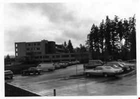
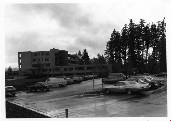
Burnaby Municipal Hall & Parking Lot
https://search.heritageburnaby.ca/link/archivedescription93635
- Repository
- City of Burnaby Archives
- Date
- October 26, 1977
- Collection/Fonds
- Burnaby Public Library Contemporary Visual Archive Project
- Description Level
- Item
- Physical Description
- 1 photograph : b&w ; 12.5 x 17.5 cm
- Scope and Content
- Photograph of the side of the exterior of Burnaby Municipal Hall, with a parking lot in the foreground. The photograph is taken facing south.
- Repository
- City of Burnaby Archives
- Date
- October 26, 1977
- Collection/Fonds
- Burnaby Public Library Contemporary Visual Archive Project
- Physical Description
- 1 photograph : b&w ; 12.5 x 17.5 cm
- Description Level
- Item
- Record No.
- 556-592
- Access Restriction
- No restrictions
- Reproduction Restriction
- Reproduce for fair dealing purposes only
- Accession Number
- 2017-57
- Scope and Content
- Photograph of the side of the exterior of Burnaby Municipal Hall, with a parking lot in the foreground. The photograph is taken facing south.
- Names
- Burnaby City Hall
- Media Type
- Photograph
- Photographer
- Surridge, Jack
- Notes
- Title taken from project information form
- Accompanied by a project information form and 1 photograph (b&w negative ; 9.5 x 12.5 cm)
- BPL no. 41
- Street Address
- 4949 Canada Way
- Historic Neighbourhood
- Burnaby Lake (Historic Neighbourhood)
- Planning Study Area
- Douglas-Gilpin Area
Images
Canadian Tire Store
https://search.heritageburnaby.ca/link/archivedescription59023
- Repository
- City of Burnaby Archives
- Date
- ca.1983
- Collection/Fonds
- Columbian Newspaper collection
- Description Level
- Item
- Physical Description
- 1 photograph : b&w ; 14.5 x 25 cm
- Scope and Content
- Photograph of the exterior of a Canadian Tire, in a plaza with other businesses, and a parking lot.
- Repository
- City of Burnaby Archives
- Date
- ca.1983
- Collection/Fonds
- Columbian Newspaper collection
- Physical Description
- 1 photograph : b&w ; 14.5 x 25 cm
- Description Level
- Item
- Record No.
- 480-1429
- Access Restriction
- No restrictions
- Reproduction Restriction
- Reproduce for fair dealing purposes only
- Accession Number
- 2009-01
- Scope and Content
- Photograph of the exterior of a Canadian Tire, in a plaza with other businesses, and a parking lot.
- Media Type
- Photograph
- Photographer
- Hodge, Craig
- Notes
- Title based on contents of photograph
- Photographer's stamp on verso
Images

![George Derby Health Centre, [between 1950 and 1954] (date of original), copied 1991 thumbnail](/media/hpo/_Data/_Archives_Images/_Unrestricted/370/370-121.jpg?width=280)
George Derby Health Centre
https://search.heritageburnaby.ca/link/archivedescription37533
- Repository
- City of Burnaby Archives
- Date
- [between 1950 and 1954] (date of original), copied 1991
- Collection/Fonds
- Burnaby Historical Society fonds
- Description Level
- Item
- Physical Description
- 1 photograph : b&w ; 2.5 x 4.1 cm print on contact sheet 20.2 x 25.3 cm
- Scope and Content
- Photograph of the George Derby Health Centre which includes the main building, parking lot and grounds.
- Repository
- City of Burnaby Archives
- Date
- [between 1950 and 1954] (date of original), copied 1991
- Collection/Fonds
- Burnaby Historical Society fonds
- Subseries
- Burnaby Image Bank subseries
- Physical Description
- 1 photograph : b&w ; 2.5 x 4.1 cm print on contact sheet 20.2 x 25.3 cm
- Description Level
- Item
- Record No.
- 370-121
- Access Restriction
- No restrictions
- Reproduction Restriction
- No restrictions
- Accession Number
- BHS1999-03
- Scope and Content
- Photograph of the George Derby Health Centre which includes the main building, parking lot and grounds.
- Subjects
- Geographic Features - Automobile Parking Lots
- Buildings - Civic - Hospitals
- Documentary Artifacts - Postcards
- Media Type
- Photograph
- Notes
- Title based on caption on photograph
- 1 b&w copy negative accompanying
- Print was copied from a postcard original
- Caption at bottom of photograph reads, "George Derby Health Centre / Burnaby B.C."
- Geographic Access
- Cumberland Street
- Street Address
- 7550 Cumberland Street
- Historic Neighbourhood
- East Burnaby (Historic Neighbourhood)
- Planning Study Area
- Cariboo-Armstrong Area
Images
![George Derby Health Centre, [between 1950 and 1954] (date of original), copied 1991 thumbnail](/media/hpo/_Data/_Archives_Images/_Unrestricted/370/370-121.jpg)
![Hotel guys, [1999] thumbnail](/media/hpo/_Data/_Archives_Images/_Unrestricted/535/535-3273-1.jpg?width=280)
Hotel guys
https://search.heritageburnaby.ca/link/archivedescription98195
- Repository
- City of Burnaby Archives
- Date
- [1999]
- Collection/Fonds
- Burnaby NewsLeader photograph collection
- Description Level
- File
- Physical Description
- 2 photographs (tiff) : col.
- Scope and Content
- File contains photographs of two unidentified people standing inside of an emptied-out hotel room and posing in the parking lot in front of an unmarked building.
- Repository
- City of Burnaby Archives
- Date
- [1999]
- Collection/Fonds
- Burnaby NewsLeader photograph collection
- Physical Description
- 2 photographs (tiff) : col.
- Description Level
- File
- Record No.
- 535-3273
- Access Restriction
- No restrictions
- Reproduction Restriction
- No restrictions
- Accession Number
- 2018-12
- Scope and Content
- File contains photographs of two unidentified people standing inside of an emptied-out hotel room and posing in the parking lot in front of an unmarked building.
- Media Type
- Photograph
- Notes
- Title based on original file name
- Collected by editorial for use in a July 1999 issue of the Burnaby NewsLeader
Images
![Hotel guys, [1999] thumbnail](/media/hpo/_Data/_Archives_Images/_Unrestricted/535/535-3273-1.jpg)

Lubbock's farm house and parking lot
https://search.heritageburnaby.ca/link/archivedescription36515
- Repository
- City of Burnaby Archives
- Date
- 1977
- Collection/Fonds
- Burnaby Historical Society fonds
- Description Level
- Item
- Physical Description
- 1 photograph : col. ; 9 x 8.5 cm
- Scope and Content
- Photograph of the side of Lubbock's farm house. Horses are being lead across the parking lot, between the parked Datsun automobiles at the entrance to the farm off of Canada Way. Both the Burnaby Lake Riding Academy and the Burnaby Lake Riding Club operated out of the Lubbock farm.
- Repository
- City of Burnaby Archives
- Date
- 1977
- Collection/Fonds
- Burnaby Historical Society fonds
- Subseries
- Lubbock family subseries
- Physical Description
- 1 photograph : col. ; 9 x 8.5 cm
- Description Level
- Item
- Record No.
- 289-004
- Access Restriction
- No restrictions
- Reproduction Restriction
- Reproduce for fair dealing purposes only
- Accession Number
- BHS1992-24
- Scope and Content
- Photograph of the side of Lubbock's farm house. Horses are being lead across the parking lot, between the parked Datsun automobiles at the entrance to the farm off of Canada Way. Both the Burnaby Lake Riding Academy and the Burnaby Lake Riding Club operated out of the Lubbock farm.
- Media Type
- Photograph
- Notes
- Title based on contents of photograph
- Geographic Access
- Grandview Highway
- Canada Way
- Burris Street
- Street Address
- 7803 Burris Street
- Historic Neighbourhood
- Burnaby Lake (Historic Neighbourhood)
- Planning Study Area
- Morley-Buckingham Area
Images

![Moscrop Secondary School, [2000] thumbnail](/media/hpo/_Data/_Archives_Images/_Unrestricted/535/535-2124-3.jpg?width=280)
Moscrop Secondary School
https://search.heritageburnaby.ca/link/archivedescription96500
- Repository
- City of Burnaby Archives
- Date
- [2000]
- Collection/Fonds
- Burnaby NewsLeader photograph collection
- Description Level
- File
- Physical Description
- 3 photographs (tiff) : b&w
- Scope and Content
- File contains photographs of Moscrop Secondary School. Photographs depict portables outside the school, with residential homes visible in the background; the school parking lot; and students gathering on the stairs and in the front lobby of the school.
- Repository
- City of Burnaby Archives
- Date
- [2000]
- Collection/Fonds
- Burnaby NewsLeader photograph collection
- Physical Description
- 3 photographs (tiff) : b&w
- Description Level
- File
- Record No.
- 535-2124
- Access Restriction
- No restrictions
- Reproduction Restriction
- No restrictions
- Accession Number
- 2018-12
- Scope and Content
- File contains photographs of Moscrop Secondary School. Photographs depict portables outside the school, with residential homes visible in the background; the school parking lot; and students gathering on the stairs and in the front lobby of the school.
- Names
- Moscrop Secondary School
- Media Type
- Photograph
- Notes
- Title based on caption
- Collected by editorial for use in a March 2000 issue of the Burnaby NewsLeader
- Geographic Access
- Moscrop Street
- Street Address
- 4433 Moscrop Street
- Planning Study Area
- Cascade-Schou Area
Images
![Moscrop Secondary School, [2000] thumbnail](/media/hpo/_Data/_Archives_Images/_Unrestricted/535/535-2124-3.jpg)
![Sambo's Pancake House, [196-] thumbnail](/media/hpo/_Data/_Archives_Images/_Unrestricted/126/201-001.jpg?width=280)
Sambo's Pancake House
https://search.heritageburnaby.ca/link/archivedescription35138
- Repository
- City of Burnaby Archives
- Date
- [196-]
- Collection/Fonds
- Burnaby Historical Society fonds
- Description Level
- Item
- Physical Description
- 1 photograph : col. postcard ; 8.9 x 14.0 cm
- Scope and Content
- Photographic postcard of the exterior and parking lot of Sambo's Pancake House, Kingsway. Printed on the top of the front of the postcard is "Sambo's Pancake House," and a sign on the building read's "Sambo's." Written on the back of the postcard: "Please surrender this card for 10% discount on you…
- Repository
- City of Burnaby Archives
- Date
- [196-]
- Collection/Fonds
- Burnaby Historical Society fonds
- Subseries
- Photographs subseries
- Physical Description
- 1 photograph : col. postcard ; 8.9 x 14.0 cm
- Description Level
- Item
- Record No.
- 201-001
- Access Restriction
- No restrictions
- Reproduction Restriction
- Reproduce for fair dealing purposes only
- Accession Number
- BHS1987-10
- Scope and Content
- Photographic postcard of the exterior and parking lot of Sambo's Pancake House, Kingsway. Printed on the top of the front of the postcard is "Sambo's Pancake House," and a sign on the building read's "Sambo's." Written on the back of the postcard: "Please surrender this card for 10% discount on your next visit to Sambo's, 5550 Kingsway, Burnaby. Offer good until Feb. 28th, 1969. Your host Sambo's."
- Subjects
- Geographic Features - Automobile Parking Lots
- Documentary Artifacts - Postcards
- Buildings - Commercial - Restaurants
- Names
- Sambo's Pancake House
- Media Type
- Photograph
- Notes
- Title based on contents of photograph
- Geographic Access
- Kingsway
- Street Address
- 5550 Kingsway
- Historic Neighbourhood
- Central Park (Historic Neighbourhood)
- Planning Study Area
- Windsor Area
Images
![Sambo's Pancake House, [196-] thumbnail](/media/hpo/_Data/_Archives_Images/_Unrestricted/126/201-001.jpg)

Social Distancing
https://search.heritageburnaby.ca/link/archivedescription95128
- Repository
- City of Burnaby Archives
- Date
- April 10, 2020
- Collection/Fonds
- Burnaby Photographic Society fonds
- Description Level
- Item
- Physical Description
- 1 photograph (tiff)
- Scope and Content
- Photograph of customers lining up outside Sungiven Foods on East Hastings Street for its grand opening. Customers are standing apart from one another, spaced by red markings on the pavement. Most customers are wearing face masks and looking at their cellphones.
- Repository
- City of Burnaby Archives
- Date
- April 10, 2020
- Collection/Fonds
- Burnaby Photographic Society fonds
- Physical Description
- 1 photograph (tiff)
- Description Level
- Item
- Record No.
- 623-046
- Access Restriction
- No restrictions
- Reproduction Restriction
- Reproduce for fair dealing purposes only
- Accession Number
- 2020-10
- Scope and Content
- Photograph of customers lining up outside Sungiven Foods on East Hastings Street for its grand opening. Customers are standing apart from one another, spaced by red markings on the pavement. Most customers are wearing face masks and looking at their cellphones.
- Media Type
- Photograph
- Photographer
- Jerome, Ron
- Notes
- Transcribed title
- Geographic Access
- Hastings Street
- Street Address
- 4106 Hastings Street
- Historic Neighbourhood
- Vancouver Heights (Historic Neighbourhood)
- Planning Study Area
- Willingdon Heights Area
Images


Standard Oil Company
https://search.heritageburnaby.ca/link/archivedescription34567
- Repository
- City of Burnaby Archives
- Date
- 1958
- Collection/Fonds
- Burnaby Historical Society fonds
- Description Level
- Item
- Physical Description
- 1 photograph : b&w ; 28.0 x 35.8 cm
- Scope and Content
- Aerial photograph of the Standard Oil Company Stanovan Refinery storage and shipping area, along the Burrard Inlet.
- Repository
- City of Burnaby Archives
- Date
- 1958
- Collection/Fonds
- Burnaby Historical Society fonds
- Subseries
- Photographs subseries
- Physical Description
- 1 photograph : b&w ; 28.0 x 35.8 cm
- Description Level
- Item
- Record No.
- 052-003
- Access Restriction
- No restrictions
- Reproduction Restriction
- Reproduce for fair dealing purposes only
- Accession Number
- BHS2007-04
- Scope and Content
- Aerial photograph of the Standard Oil Company Stanovan Refinery storage and shipping area, along the Burrard Inlet.
- Media Type
- Photograph
- Notes
- Title based on contents of photograph
- Geographic Access
- Eton Street
- Street Address
- 4403 Eton Street
- Historic Neighbourhood
- Vancouver Heights (Historic Neighbourhood)
- Planning Study Area
- Burnaby Heights Area
Images


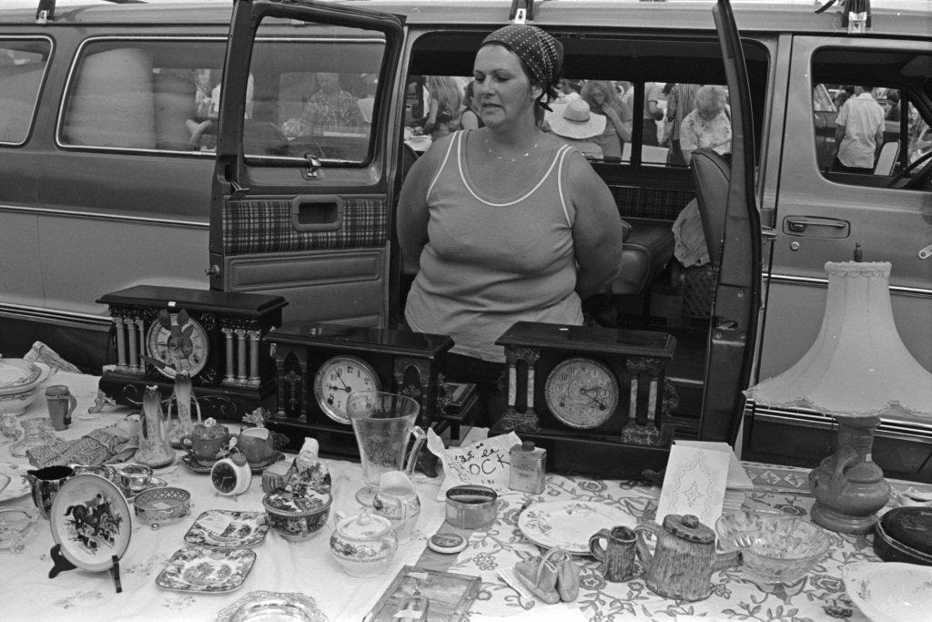
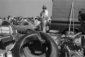
Antique clocks and flatware
https://search.heritageburnaby.ca/link/archivedescription70349
- Repository
- City of Burnaby Archives
- Date
- 1978
- Collection/Fonds
- Bill Jeffries fonds
- Description Level
- Item
- Physical Description
- 1 photograph : b&w negative ; 35 mm
- Scope and Content
- Photograph of a table of antique clocks and flatware at the Lougheed Drive-in swap meet in the summer of 1978. An unidentified vendor is standing behind the table with her hands behind her back.
- Repository
- City of Burnaby Archives
- Date
- 1978
- Collection/Fonds
- Bill Jeffries fonds
- Physical Description
- 1 photograph : b&w negative ; 35 mm
- Description Level
- Item
- Record No.
- 528-045
- Access Restriction
- No restrictions
- Reproduction Restriction
- No restrictions
- Accession Number
- 2011-01
- Scope and Content
- Photograph of a table of antique clocks and flatware at the Lougheed Drive-in swap meet in the summer of 1978. An unidentified vendor is standing behind the table with her hands behind her back.
- Media Type
- Photograph
- Photographer
- Jeffries, Bill
- Notes
- Title based on contents of item
- Geographic Access
- Lougheed Highway
- Historic Neighbourhood
- Broadview (Historic Neighbourhood)
- Planning Study Area
- West Central Valley Area
Images
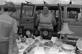
Antique clocks and flatware
https://search.heritageburnaby.ca/link/archivedescription70423
- Repository
- City of Burnaby Archives
- Date
- 1978
- Collection/Fonds
- Bill Jeffries fonds
- Description Level
- Item
- Physical Description
- 1 photograph : b&w negative ; 35 mm
- Scope and Content
- Photograph of a table of antique clocks and flatware at the Lougheed Drive-in swap meet in the summer of 1978. An unidentified vendor is standing behind the table, smiling at a potential customer.
- Repository
- City of Burnaby Archives
- Date
- 1978
- Collection/Fonds
- Bill Jeffries fonds
- Physical Description
- 1 photograph : b&w negative ; 35 mm
- Description Level
- Item
- Record No.
- 528-119
- Access Restriction
- No restrictions
- Reproduction Restriction
- No restrictions
- Accession Number
- 2011-01
- Scope and Content
- Photograph of a table of antique clocks and flatware at the Lougheed Drive-in swap meet in the summer of 1978. An unidentified vendor is standing behind the table, smiling at a potential customer.
- Media Type
- Photograph
- Photographer
- Jeffries, Bill
- Notes
- Title based on contents of item
- Geographic Access
- Lougheed Highway
- Historic Neighbourhood
- Broadview (Historic Neighbourhood)
- Planning Study Area
- West Central Valley Area
Images

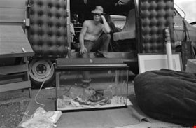
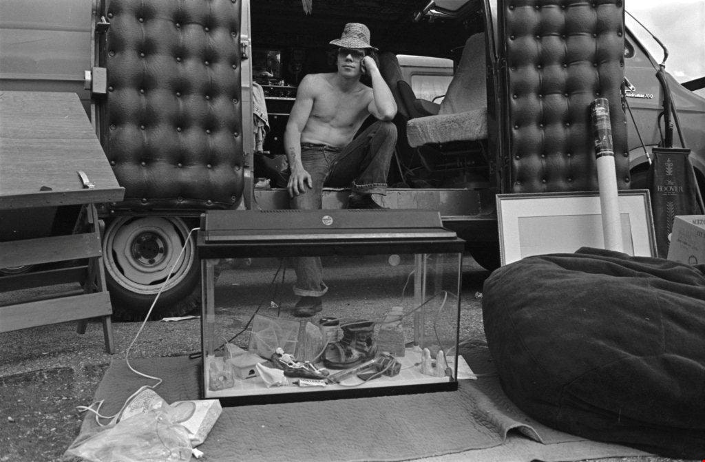
Aquarium and bean bag chair
https://search.heritageburnaby.ca/link/archivedescription70344
- Repository
- City of Burnaby Archives
- Date
- 1978
- Collection/Fonds
- Bill Jeffries fonds
- Description Level
- Item
- Physical Description
- 1 photograph : b&w negative ; 35 mm
- Scope and Content
- Photograph of a diverse collection of wares that includes an aquarium and a bean bag chair at the Lougheed Drive-in swap meet in the summer of 1978. An unidentified vendor is seated at a side door of the van parked behind the aquarium.
- Repository
- City of Burnaby Archives
- Date
- 1978
- Collection/Fonds
- Bill Jeffries fonds
- Physical Description
- 1 photograph : b&w negative ; 35 mm
- Description Level
- Item
- Record No.
- 528-040
- Access Restriction
- No restrictions
- Reproduction Restriction
- No restrictions
- Accession Number
- 2011-01
- Scope and Content
- Photograph of a diverse collection of wares that includes an aquarium and a bean bag chair at the Lougheed Drive-in swap meet in the summer of 1978. An unidentified vendor is seated at a side door of the van parked behind the aquarium.
- Media Type
- Photograph
- Photographer
- Jeffries, Bill
- Notes
- Title based on contents of item
- Geographic Access
- Lougheed Highway
- Historic Neighbourhood
- Broadview (Historic Neighbourhood)
- Planning Study Area
- West Central Valley Area
Images
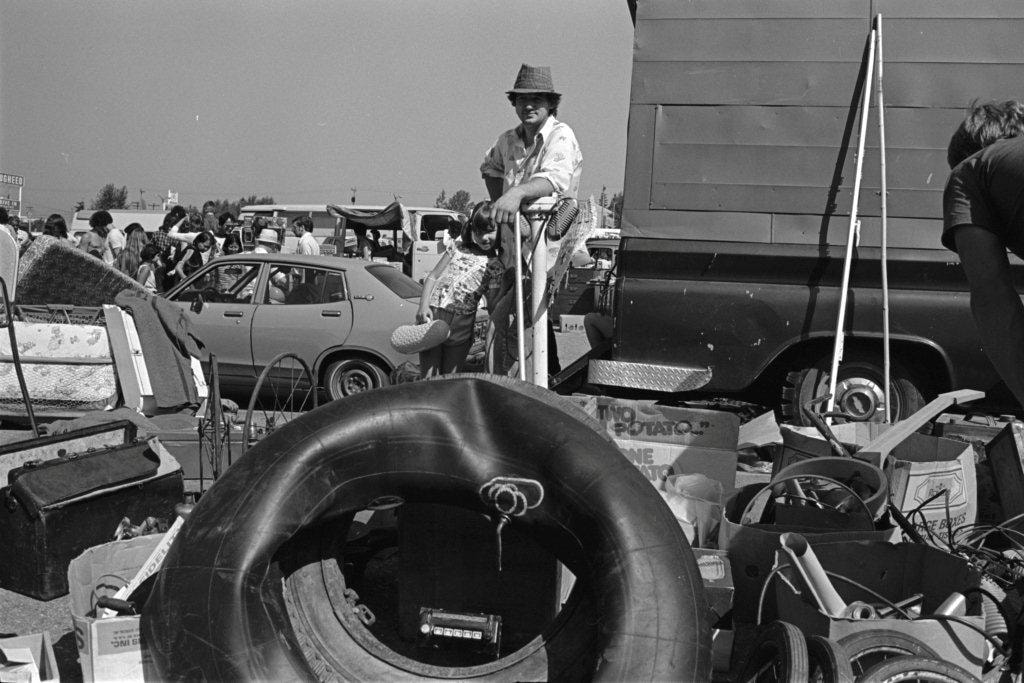
A vendor and his daughter
https://search.heritageburnaby.ca/link/archivedescription70279
- Repository
- City of Burnaby Archives
- Date
- 1978
- Collection/Fonds
- Bill Jeffries fonds
- Description Level
- Item
- Physical Description
- 1 photograph : b&w negative ; 35 mm
- Scope and Content
- Photograph of an unidentified vendor standing behind his wares with a young girl at his side at the Lougheed Drive-in swap meet in the summer of 1978. Both the girl and the vendor are facing the camera.
- Repository
- City of Burnaby Archives
- Date
- 1978
- Collection/Fonds
- Bill Jeffries fonds
- Physical Description
- 1 photograph : b&w negative ; 35 mm
- Description Level
- Item
- Record No.
- 528-013
- Access Restriction
- No restrictions
- Reproduction Restriction
- No restrictions
- Accession Number
- 2011-01
- Scope and Content
- Photograph of an unidentified vendor standing behind his wares with a young girl at his side at the Lougheed Drive-in swap meet in the summer of 1978. Both the girl and the vendor are facing the camera.
- Media Type
- Photograph
- Photographer
- Jeffries, Bill
- Notes
- Title based on contents of item
- 1 b&w print (12.5 x 17.5 cm) accompanying
- Geographic Access
- Lougheed Highway
- Historic Neighbourhood
- Broadview (Historic Neighbourhood)
- Planning Study Area
- West Central Valley Area
Images