More like 'Kitchener Street'
Narrow Results By
Decade
- 2020s 63
- 2010s 113
- 2000s 527
- 1990s
- 1980s 307
- 1970s
- 1960s 343
- 1950s 337
- 1940s 610
- 1930s 449
- 1920s 541
- 1910s 479
- 1900s 225
- 1890s 39
- 1880s 32
- 1870s 5
- 1860s 5
- 1850s 2
- 1840s 1
- 1830s 1
- 1820s 1
- 1810s 2
- 1800s 2
- 1790s 2
- 1780s 2
- 1770s 2
- 1760s 2
- 1750s 2
- 1740s 2
- 1730s 2
- 1720s 2
- 1710s 2
- 1700s 2
- 1690s 2
- 1680s 2
- 1670s 2
- 1660s 2
- 1650s 2
- 1640s 2
- 1630s 2
- 1620s 2
- 1610s 2
- 1600s 2
- 1590s 1
- 1580s 1
- 1570s 1
- 1560s 1
- 1550s 1
- 1540s 1
- 1530s 1
- 1520s 1
- 1510s 1
- 1500s 1
- 1490s 1
- 1480s 1
![Land surveyor on a road, [1999] thumbnail](/media/hpo/_Data/_Archives_Images/_Unrestricted/535/535-3313.jpg?width=280)
Land surveyor on a road
https://search.heritageburnaby.ca/link/archivedescription98246
- Repository
- City of Burnaby Archives
- Date
- [1999]
- Collection/Fonds
- Burnaby NewsLeader photograph collection
- Description Level
- Item
- Physical Description
- 1 photograph (tiff) : b&w
- Scope and Content
- Photograph of an unidentified land surveyor standing behind a land surveying total station at the curve of a road.
- Repository
- City of Burnaby Archives
- Date
- [1999]
- Collection/Fonds
- Burnaby NewsLeader photograph collection
- Physical Description
- 1 photograph (tiff) : b&w
- Description Level
- Item
- Record No.
- 535-3313
- Access Restriction
- No restrictions
- Reproduction Restriction
- No restrictions
- Accession Number
- 2018-12
- Scope and Content
- Photograph of an unidentified land surveyor standing behind a land surveying total station at the curve of a road.
- Media Type
- Photograph
- Notes
- Title based on contents of photograph
- Collected by editorial for use in a September 1999 issue of the Burnaby NewsLeader
Images
![Land surveyor on a road, [1999] thumbnail](/media/hpo/_Data/_Archives_Images/_Unrestricted/535/535-3313.jpg)
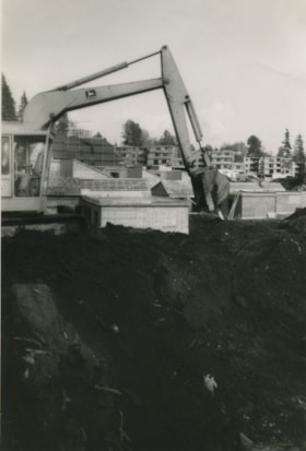
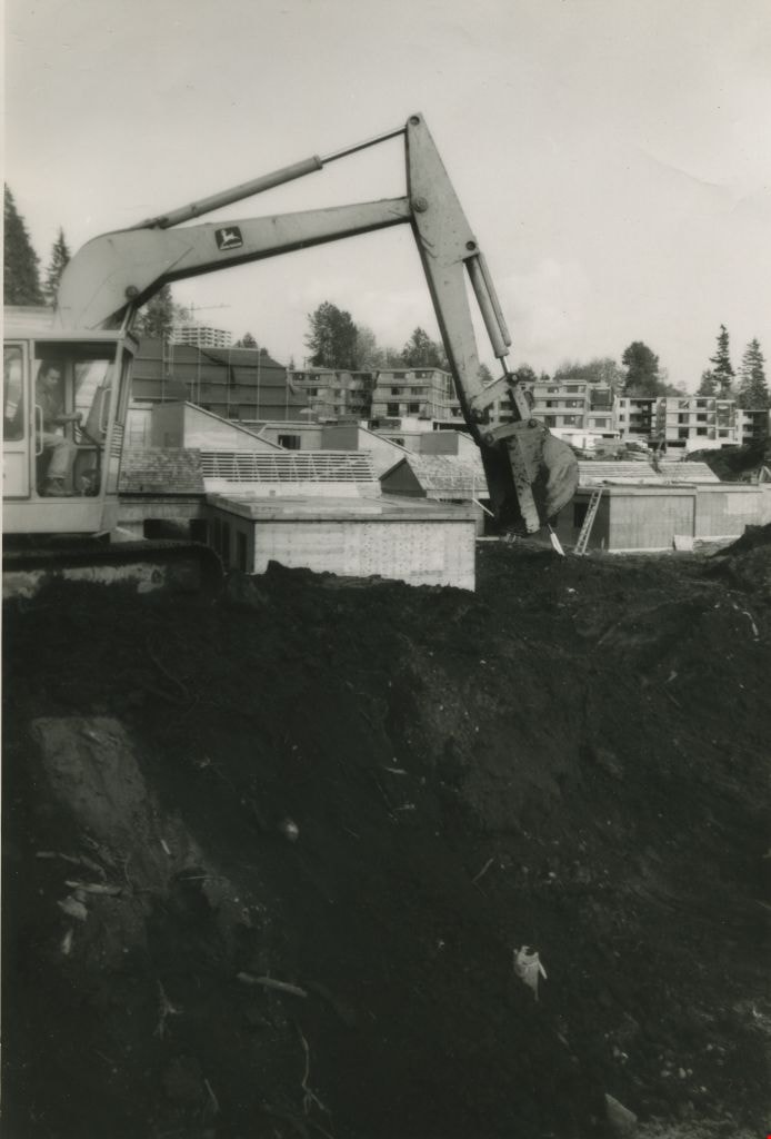
Construction of MacInnis Place
https://search.heritageburnaby.ca/link/archivedescription45401
- Repository
- City of Burnaby Archives
- Date
- 1975
- Collection/Fonds
- Columbian Newspaper collection
- Description Level
- Item
- Physical Description
- 1 photograph : b&w ; 21 x 14.5 cm
- Scope and Content
- Photograph of caterpiliar operator Casey Logan moving a large pile of earth to build a sound barrier for the British Columbia government housing project at MacInnis Place.
- Repository
- City of Burnaby Archives
- Date
- 1975
- Collection/Fonds
- Columbian Newspaper collection
- Physical Description
- 1 photograph : b&w ; 21 x 14.5 cm
- Description Level
- Item
- Record No.
- 480-296
- Access Restriction
- No restrictions
- Reproduction Restriction
- Reproduce for fair dealing purposes only
- Accession Number
- 2003-02
- Scope and Content
- Photograph of caterpiliar operator Casey Logan moving a large pile of earth to build a sound barrier for the British Columbia government housing project at MacInnis Place.
- Names
- MacInnis Place
- Media Type
- Photograph
- Notes
- Title based on contents of photograph
- Newspaper clipping attached to verso of photograph reads: "BIG BARRIER Mountain of earth is moved by 'cat' operator Casey Logan to build a sound barrier for the new B.C. government housing project at MacInnis Place in Burnaby."
- Geographic Access
- Keswick Avenue
- Historic Neighbourhood
- Burquitlam (Historic Neighbourhood)
- Planning Study Area
- Cameron Area
Images
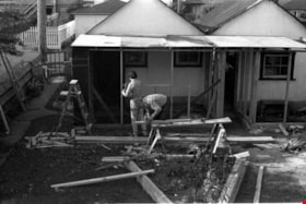
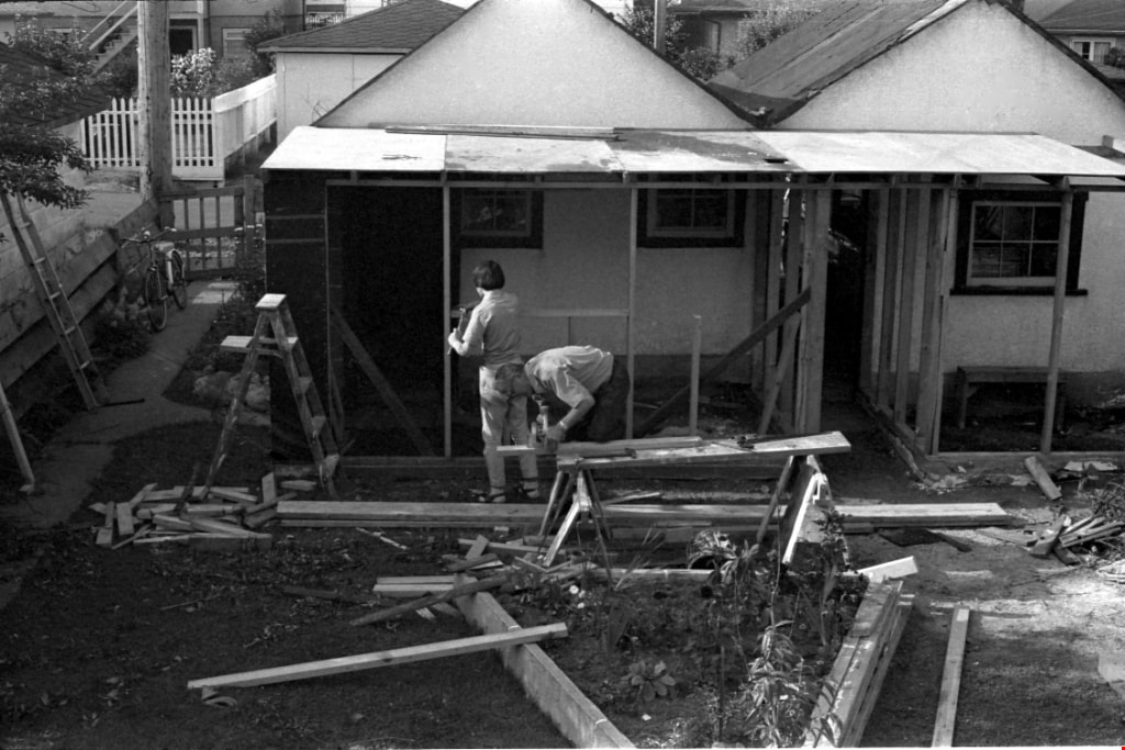
Garage construction
https://search.heritageburnaby.ca/link/archivedescription51756
- Repository
- City of Burnaby Archives
- Date
- 1971
- Collection/Fonds
- Harold H. Johnston fonds
- Description Level
- Item
- Physical Description
- 1 photograph (jpeg) : b&w
- Scope and Content
- Photograph of two men working on a garage identified as belonging to Sean Pepere. Construction material and debris are visible around the worksite The photograph was most likely taken in the Venables Street area of Burnaby.
- Repository
- City of Burnaby Archives
- Date
- 1971
- Collection/Fonds
- Harold H. Johnston fonds
- Physical Description
- 1 photograph (jpeg) : b&w
- Description Level
- Item
- Record No.
- 483-084
- Access Restriction
- No restrictions
- Reproduction Restriction
- No reproduction permitted
- Accession Number
- 2008-08
- Scope and Content
- Photograph of two men working on a garage identified as belonging to Sean Pepere. Construction material and debris are visible around the worksite The photograph was most likely taken in the Venables Street area of Burnaby.
- Media Type
- Photograph
- Photographer
- Johnston, Harold H.
- Notes
- Title based on contents of photograph
- Geographic Access
- Venables Street
- Historic Neighbourhood
- Vancouver Heights (Historic Neighbourhood)
- Planning Study Area
- Willingdon Heights Area
Images
![Ken Shymka at Still Creek, [1999] thumbnail](/media/hpo/_Data/_Archives_Images/_Unrestricted/535/535-3319-2.jpg?width=280)
Ken Shymka at Still Creek
https://search.heritageburnaby.ca/link/archivedescription98252
- Repository
- City of Burnaby Archives
- Date
- [1999]
- Collection/Fonds
- Burnaby NewsLeader photograph collection
- Description Level
- File
- Physical Description
- 2 photographs (tiff) : col.
- Scope and Content
- File contains photographs of photographer Ken Shymka posing with his camera at Still Creek.
- Repository
- City of Burnaby Archives
- Date
- [1999]
- Collection/Fonds
- Burnaby NewsLeader photograph collection
- Physical Description
- 2 photographs (tiff) : col.
- Description Level
- File
- Record No.
- 535-3319
- Access Restriction
- No restrictions
- Reproduction Restriction
- No restrictions
- Accession Number
- 2018-12
- Scope and Content
- File contains photographs of photographer Ken Shymka posing with his camera at Still Creek.
- Subjects
- Occupations - Photographers
- Geographic Features - Creeks
- Geographic Features - Streams
- Photographic Tools and Equipment - Camera
- Media Type
- Photograph
- Notes
- Title based on contents of file
- Collected by editorial for use in a September 1999 issue of the Burnaby NewsLeader
- Geographic Access
- Still Creek
Images
![Ken Shymka at Still Creek, [1999] thumbnail](/media/hpo/_Data/_Archives_Images/_Unrestricted/535/535-3319-2.jpg)
![Rower and dredger on Burnaby Lake, [1999] thumbnail](/media/hpo/_Data/_Archives_Images/_Unrestricted/535/535-3310.jpg?width=280)
Rower and dredger on Burnaby Lake
https://search.heritageburnaby.ca/link/archivedescription98232
- Repository
- City of Burnaby Archives
- Date
- [1999]
- Collection/Fonds
- Burnaby NewsLeader photograph collection
- Description Level
- Item
- Physical Description
- 1 photograph (tiff) : col.
- Scope and Content
- Photograph of an unidentified rower rowing on Burnaby Lake as a dredger works in the lake in the background.
- Repository
- City of Burnaby Archives
- Date
- [1999]
- Collection/Fonds
- Burnaby NewsLeader photograph collection
- Physical Description
- 1 photograph (tiff) : col.
- Description Level
- Item
- Record No.
- 535-3310
- Access Restriction
- No restrictions
- Reproduction Restriction
- No restrictions
- Accession Number
- 2018-12
- Scope and Content
- Photograph of an unidentified rower rowing on Burnaby Lake as a dredger works in the lake in the background.
- Subjects
- Recreational Activities - Boating
- Construction Tools and Equipment
- Geographic Features - Lakes and Ponds
- Media Type
- Photograph
- Notes
- Title based on original file name
- Collected by editorial for use in an August 1999 issue of the Burnaby NewsLeader
- Geographic Access
- Burnaby Lake
- Burnaby Lake Regional Nature Park
- Historic Neighbourhood
- Burnaby Lake (Historic Neighbourhood)
- Planning Study Area
- Burnaby Lake Area
Images
![Rower and dredger on Burnaby Lake, [1999] thumbnail](/media/hpo/_Data/_Archives_Images/_Unrestricted/535/535-3310.jpg)

Widening of Scott Road
https://search.heritageburnaby.ca/link/archivedescription56677
- Repository
- City of Burnaby Archives
- Date
- March 1976, published March 24, 1976
- Collection/Fonds
- Columbian Newspaper collection
- Description Level
- Item
- Physical Description
- 1 photograph : b&w ; 7.5 x 14 cm
- Scope and Content
- Photograph of the process of widening Scott Road in Surrey BC. The process was undertaken by the provincial government. Citizens were upset as this process included cutting down century-old trees (stumps of these former trees are visible in this photograph).
- Repository
- City of Burnaby Archives
- Date
- March 1976, published March 24, 1976
- Collection/Fonds
- Columbian Newspaper collection
- Physical Description
- 1 photograph : b&w ; 7.5 x 14 cm
- Description Level
- Item
- Record No.
- 480-531
- Access Restriction
- No restrictions
- Reproduction Restriction
- No restrictions
- Accession Number
- 2003-02
- Scope and Content
- Photograph of the process of widening Scott Road in Surrey BC. The process was undertaken by the provincial government. Citizens were upset as this process included cutting down century-old trees (stumps of these former trees are visible in this photograph).
- Media Type
- Photograph
- Photographer
- King, Basil
- Notes
- Title based on contents of photograph
- Newspaper clipping attached to verso of photograph reads: "Road-widening on Scott Rd. in Surrey has taken its toll of old trees."
Images

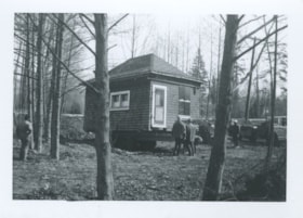
Irvine house being installed
https://search.heritageburnaby.ca/link/museumdescription1877
- Repository
- Burnaby Village Museum
- Date
- April 6, 1975
- Collection/Fonds
- Century Park Museum Association fonds
- Description Level
- Item
- Physical Description
- 1 photograph : b&w ; 7 x 10 cm
- Scope and Content
- Photograph of Tom Irvine's house during its installation at Heritage Village (now the Burnaby Village Museum). Men surround the house as it sits on a gooseneck trailer stationed inside a fence.
- Repository
- Burnaby Village Museum
- Collection/Fonds
- Century Park Museum Association fonds
- Description Level
- Item
- Physical Description
- 1 photograph : b&w ; 7 x 10 cm
- Scope and Content
- Photograph of Tom Irvine's house during its installation at Heritage Village (now the Burnaby Village Museum). Men surround the house as it sits on a gooseneck trailer stationed inside a fence.
- Geographic Access
- Deer Lake Drive
- Accession Code
- BV005.14.31
- Access Restriction
- Restricted access
- Reproduction Restriction
- May be restricted by third party rights
- Date
- April 6, 1975
- Media Type
- Photograph
- Scan Resolution
- 600
- Scan Date
- 11-Jun-09
- Scale
- 100
- Notes
- Title based on contents of photograph
- Note in pencil on verso of photograph reads: "April/75"
Images

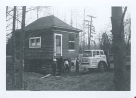
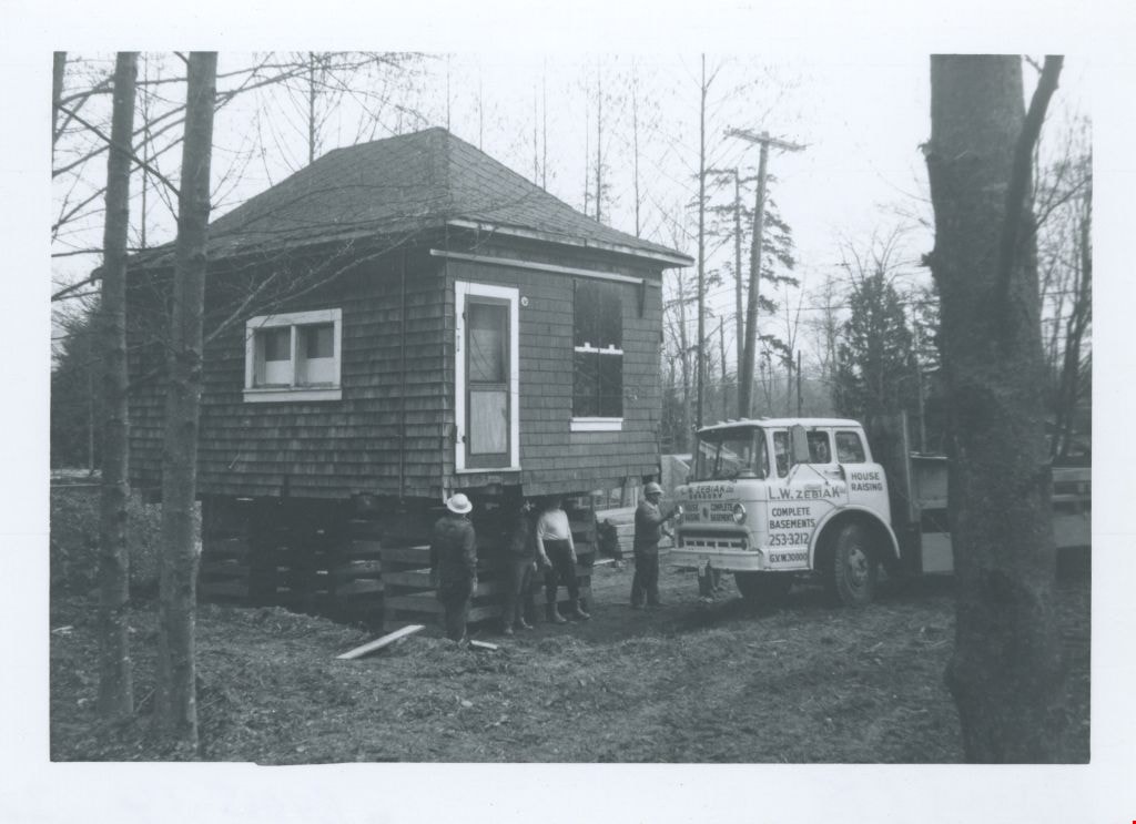
Irvine house being installed
https://search.heritageburnaby.ca/link/museumdescription1878
- Repository
- Burnaby Village Museum
- Date
- April 6, 1975
- Collection/Fonds
- Century Park Museum Association fonds
- Description Level
- Item
- Physical Description
- 1 photograph : b&w ; 7 x 10 cm
- Scope and Content
- Photograph of Tom Irvine's house during its installation at Heritage Village (now the Burnaby Village Museum). The house is raised on a cribbing and surrounded by workmen. A truck parked next to it has a sign that reads, "L.W. ZEBIAK HOUSE RAISING COMPLETE BASEMENTS."
- Repository
- Burnaby Village Museum
- Collection/Fonds
- Century Park Museum Association fonds
- Description Level
- Item
- Physical Description
- 1 photograph : b&w ; 7 x 10 cm
- Scope and Content
- Photograph of Tom Irvine's house during its installation at Heritage Village (now the Burnaby Village Museum). The house is raised on a cribbing and surrounded by workmen. A truck parked next to it has a sign that reads, "L.W. ZEBIAK HOUSE RAISING COMPLETE BASEMENTS."
- Subjects
- Buildings - Residential - Houses
- Tools and Equipment
- Transportation - Trucks
- Occupations - Labourers
- Geographic Access
- Deer Lake Drive
- Accession Code
- BV005.14.32
- Access Restriction
- Restricted access
- Reproduction Restriction
- May be restricted by third party rights
- Date
- April 6, 1975
- Media Type
- Photograph
- Scan Resolution
- 600
- Scan Date
- 11-Jun-09
- Scale
- 100
- Notes
- Title based on contents of photograph
- Note in pencil on verso of photograph reads: "April/75"
Images
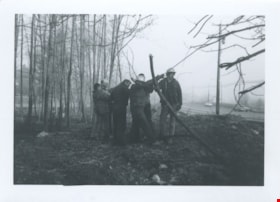
Pulling on a rope
https://search.heritageburnaby.ca/link/museumdescription1876
- Repository
- Burnaby Village Museum
- Date
- April 6, 1975
- Collection/Fonds
- Century Park Museum Association fonds
- Description Level
- Item
- Physical Description
- 1 photograph : b&w ; 7 x 10 cm
- Scope and Content
- Photograph of a crew of men pulling on a rope, possibly to pull tree branches out of the way, or to stabilize Tom Irvine's house during its move to Heritage Village (now the Burnaby Village Museum).
- Repository
- Burnaby Village Museum
- Collection/Fonds
- Century Park Museum Association fonds
- Description Level
- Item
- Physical Description
- 1 photograph : b&w ; 7 x 10 cm
- Scope and Content
- Photograph of a crew of men pulling on a rope, possibly to pull tree branches out of the way, or to stabilize Tom Irvine's house during its move to Heritage Village (now the Burnaby Village Museum).
- Names
- Irvine, Tom
- Accession Code
- BV005.14.30
- Access Restriction
- Restricted access
- Reproduction Restriction
- May be restricted by third party rights
- Date
- April 6, 1975
- Media Type
- Photograph
- Historic Neighbourhood
- Burnaby Lake (Historic Neighbourhood)
- Scan Resolution
- 600
- Scan Date
- 11-Jun-09
- Scale
- 100
- Notes
- Title based on contents of photograph
- Note in pencil on verso of photograph reads: "April/75"
Images

7165-7177 17th Ave and 7164-7176 18th Ave
https://search.heritageburnaby.ca/link/archivedescription93752
- Repository
- City of Burnaby Archives
- Date
- April 30, 1992
- Collection/Fonds
- Grover, Elliott & Co. Ltd. fonds
- Description Level
- File
- Physical Description
- 23 photographs : col. negatives ; 35 mm
- Scope and Content
- Photographs of the single-family houses located at 7165-7177 17th Avenue and 7164-7176 18th Avenue - addresses that no longer exist - as well as a building being constructed. The current address of the properties is 7175 17th Avenue.
- Repository
- City of Burnaby Archives
- Date
- April 30, 1992
- Collection/Fonds
- Grover, Elliott & Co. Ltd. fonds
- Physical Description
- 23 photographs : col. negatives ; 35 mm
- Description Level
- File
- Record No.
- 622-037
- Access Restriction
- No restrictions
- Reproduction Restriction
- No restrictions
- Accession Number
- 2017-39
- Scope and Content
- Photographs of the single-family houses located at 7165-7177 17th Avenue and 7164-7176 18th Avenue - addresses that no longer exist - as well as a building being constructed. The current address of the properties is 7175 17th Avenue.
- Media Type
- Photograph
- Photographer
- Cameron, James
- Notes
- Transcribed title
- Title transcribed from envelope photographs were originally housed in
- File no. 92-135-B
- Geographic Access
- 17th Avenue
- 18th Avenue

Burris Street
https://search.heritageburnaby.ca/link/archivedescription36530
- Repository
- City of Burnaby Archives
- Date
- November 1978
- Collection/Fonds
- Burnaby Historical Society fonds
- Description Level
- Item
- Physical Description
- 1 photograph : col. ; 9 x 8.5 cm
- Scope and Content
- Photograph of Burris Street, including the "new" townhouse complex at One Arbour Lane when it was under construction.
- Repository
- City of Burnaby Archives
- Date
- November 1978
- Collection/Fonds
- Burnaby Historical Society fonds
- Subseries
- Lubbock family subseries
- Physical Description
- 1 photograph : col. ; 9 x 8.5 cm
- Description Level
- Item
- Record No.
- 289-019
- Access Restriction
- No restrictions
- Reproduction Restriction
- Reproduce for fair dealing purposes only
- Accession Number
- BHS1992-24
- Scope and Content
- Photograph of Burris Street, including the "new" townhouse complex at One Arbour Lane when it was under construction.
- Media Type
- Photograph
- Notes
- Title based on contents of photograph
- Geographic Access
- Burris Street
- Mayview Circle
- Historic Neighbourhood
- Burnaby Lake (Historic Neighbourhood)
- Planning Study Area
- Morley-Buckingham Area
Images

Henning dr. [sic] Burnaby
https://search.heritageburnaby.ca/link/archivedescription93838
- Repository
- City of Burnaby Archives
- Date
- January 1993
- Collection/Fonds
- Grover, Elliott & Co. Ltd. fonds
- Description Level
- File
- Physical Description
- 24 photographs : col. negatives ; 35 mm
- Scope and Content
- Photographs of the Bridge Business Park under construction. The Bridge Business Park is located between Lougheed Highway and Henning Drive and Boundary Road and Gilmore Avenue.
- Repository
- City of Burnaby Archives
- Date
- January 1993
- Collection/Fonds
- Grover, Elliott & Co. Ltd. fonds
- Physical Description
- 24 photographs : col. negatives ; 35 mm
- Description Level
- File
- Record No.
- 622-063
- Access Restriction
- No restrictions
- Reproduction Restriction
- No restrictions
- Accession Number
- 2017-39
- Scope and Content
- Photographs of the Bridge Business Park under construction. The Bridge Business Park is located between Lougheed Highway and Henning Drive and Boundary Road and Gilmore Avenue.
- Subjects
- Geographic Features - Roads
- Construction
- Media Type
- Photograph
- Notes
- Transcribed title
- Title transcribed from envelope photographs were originally housed in
- File no. 93-031-B
- Photographer identified as "K.D."
- Geographic Access
- Henning Drive
- Historic Neighbourhood
- Broadview (Historic Neighbourhood)
- Planning Study Area
- West Central Valley Area
![Artificial turf at Burnaby Lake Sports Complex, [1999] thumbnail](/media/hpo/_Data/_Archives_Images/_Unrestricted/535/535-3300-1.jpg?width=280)
Artificial turf at Burnaby Lake Sports Complex
https://search.heritageburnaby.ca/link/archivedescription98222
- Repository
- City of Burnaby Archives
- Date
- [1999]
- Collection/Fonds
- Burnaby NewsLeader photograph collection
- Description Level
- File
- Physical Description
- 2 photographs (tiff) : col.
- Scope and Content
- File contains photographs of Pierre Alarie, the crew chief for Field Turf International, checking and installing artificial turf at the a new field at the Burnaby Lake Sports Complex.
- Repository
- City of Burnaby Archives
- Date
- [1999]
- Collection/Fonds
- Burnaby NewsLeader photograph collection
- Physical Description
- 2 photographs (tiff) : col.
- Description Level
- File
- Record No.
- 535-3300
- Access Restriction
- No restrictions
- Reproduction Restriction
- No restrictions
- Accession Number
- 2018-12
- Scope and Content
- File contains photographs of Pierre Alarie, the crew chief for Field Turf International, checking and installing artificial turf at the a new field at the Burnaby Lake Sports Complex.
- Media Type
- Photograph
- Photographer
- Bartel, Mario
- Notes
- Title based on caption
- Collected by editorial for use in an August 1999 issue of the Burnaby NewsLeader
- Caption from metadata for 535-3300-1: "Pierre Alarie, the crew chief for Field Turf International, checks the artificial turf his company is installing at the new field complex off Kensington."
- Geographic Access
- Kensington Avenue
- Burnaby Lake Sports Complex
- Historic Neighbourhood
- Burnaby Lake (Historic Neighbourhood)
- Planning Study Area
- Ardingley-Sprott Area
Images
![Artificial turf at Burnaby Lake Sports Complex, [1999] thumbnail](/media/hpo/_Data/_Archives_Images/_Unrestricted/535/535-3300-1.jpg)
![Trimming hedges in the Metrotown area, [1999] thumbnail](/media/hpo/_Data/_Archives_Images/_Unrestricted/535/535-3390.jpg?width=280)
Trimming hedges in the Metrotown area
https://search.heritageburnaby.ca/link/archivedescription98380
- Repository
- City of Burnaby Archives
- Date
- [1999]
- Collection/Fonds
- Burnaby NewsLeader photograph collection
- Description Level
- Item
- Physical Description
- 1 photograph (tiff) : col.
- Scope and Content
- Photograph of two unidentified people trimming hedges in the Metrotown area. The SkyTrain tracks, Metropolis at Metrotown mall, and towers are visible behind them.
- Repository
- City of Burnaby Archives
- Date
- [1999]
- Collection/Fonds
- Burnaby NewsLeader photograph collection
- Physical Description
- 1 photograph (tiff) : col.
- Description Level
- Item
- Record No.
- 535-3390
- Access Restriction
- No restrictions
- Reproduction Restriction
- No restrictions
- Accession Number
- 2018-12
- Scope and Content
- Photograph of two unidentified people trimming hedges in the Metrotown area. The SkyTrain tracks, Metropolis at Metrotown mall, and towers are visible behind them.
- Names
- Metrotown
- Media Type
- Photograph
- Notes
- Title based on contents of photograph
- Collected by editorial for use in an October 1999 issue of the Burnaby NewsLeader
- Historic Neighbourhood
- Central Park (Historic Neighbourhood)
- Planning Study Area
- Maywood Area
Images
![Trimming hedges in the Metrotown area, [1999] thumbnail](/media/hpo/_Data/_Archives_Images/_Unrestricted/535/535-3390.jpg)
![Disco ball maker, [1999] thumbnail](/media/hpo/_Data/_Archives_Images/_Unrestricted/535/535-3257.jpg?width=280)
Disco ball maker
https://search.heritageburnaby.ca/link/archivedescription98179
- Repository
- City of Burnaby Archives
- Date
- [1999]
- Collection/Fonds
- Burnaby NewsLeader photograph collection
- Description Level
- Item
- Physical Description
- 1 photograph (tiff) : col.
- Scope and Content
- Photograph of an unidentified person in a studio, using a caulk gun to make a disco ball.
- Repository
- City of Burnaby Archives
- Date
- [1999]
- Collection/Fonds
- Burnaby NewsLeader photograph collection
- Physical Description
- 1 photograph (tiff) : col.
- Description Level
- Item
- Record No.
- 535-3257
- Access Restriction
- No restrictions
- Reproduction Restriction
- No restrictions
- Accession Number
- 2018-12
- Scope and Content
- Photograph of an unidentified person in a studio, using a caulk gun to make a disco ball.
- Media Type
- Photograph
- Notes
- Title based on contents of photograph
- Collected by editorial for use in a July 1999 issue of the Burnaby NewsLeader
Images
![Disco ball maker, [1999] thumbnail](/media/hpo/_Data/_Archives_Images/_Unrestricted/535/535-3257.jpg)
![Worker with sandbags, [1999] thumbnail](/media/hpo/_Data/_Archives_Images/_Unrestricted/535/535-3195.jpg?width=280)
Worker with sandbags
https://search.heritageburnaby.ca/link/archivedescription98116
- Repository
- City of Burnaby Archives
- Date
- [1999]
- Collection/Fonds
- Burnaby NewsLeader photograph collection
- Description Level
- Item
- Physical Description
- 1 photograph (tiff) : col.
- Scope and Content
- Photograph of an unidentified worker, wearing a reflective vest and a hardhat, preparing a sandbag and surrounded by a lot of large sandbags.
- Repository
- City of Burnaby Archives
- Date
- [1999]
- Collection/Fonds
- Burnaby NewsLeader photograph collection
- Physical Description
- 1 photograph (tiff) : col.
- Description Level
- Item
- Record No.
- 535-3195
- Access Restriction
- No restrictions
- Reproduction Restriction
- No restrictions
- Accession Number
- 2018-12
- Scope and Content
- Photograph of an unidentified worker, wearing a reflective vest and a hardhat, preparing a sandbag and surrounded by a lot of large sandbags.
- Media Type
- Photograph
- Notes
- Title based on contents of photograph
- Collected by editorial for use in a May 1999 issue of the Burnaby NewsLeader
Images
![Worker with sandbags, [1999] thumbnail](/media/hpo/_Data/_Archives_Images/_Unrestricted/535/535-3195.jpg)
![Police officer at Royal Oak and Kingsway, [1999] thumbnail](/media/hpo/_Data/_Archives_Images/_Unrestricted/535/535-3258.jpg?width=280)
Police officer at Royal Oak and Kingsway
https://search.heritageburnaby.ca/link/archivedescription98180
- Repository
- City of Burnaby Archives
- Date
- [1999]
- Collection/Fonds
- Burnaby NewsLeader photograph collection
- Description Level
- Item
- Physical Description
- 1 photograph (tiff) : col.
- Scope and Content
- Photograph of a Burnaby RCMP officer wearing a reflective vest and standing on the sidewalk by a bus stop on Kingsway, across the street from a Safeway, at the intersection of Royal Oak Avenue and Kingsway.
- Repository
- City of Burnaby Archives
- Date
- [1999]
- Collection/Fonds
- Burnaby NewsLeader photograph collection
- Physical Description
- 1 photograph (tiff) : col.
- Description Level
- Item
- Record No.
- 535-3258
- Access Restriction
- No restrictions
- Reproduction Restriction
- No restrictions
- Accession Number
- 2018-12
- Scope and Content
- Photograph of a Burnaby RCMP officer wearing a reflective vest and standing on the sidewalk by a bus stop on Kingsway, across the street from a Safeway, at the intersection of Royal Oak Avenue and Kingsway.
- Subjects
- Occupations - Police Officers
- Geographic Features - Roads
- Buildings - Commercial - Grocery Stores
- Media Type
- Photograph
- Notes
- Title based on contents of photograph
- Collected by editorial for use in a July 1999 issue of the Burnaby NewsLeader
- Geographic Access
- Kingsway
- Royal Oak Avenue
- Historic Neighbourhood
- Central Park (Historic Neighbourhood)
- Planning Study Area
- Windsor Area
Images
![Police officer at Royal Oak and Kingsway, [1999] thumbnail](/media/hpo/_Data/_Archives_Images/_Unrestricted/535/535-3258.jpg)
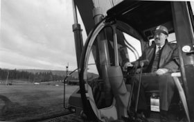
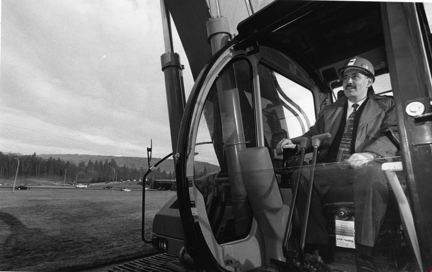
Glen Clark
https://search.heritageburnaby.ca/link/archivedescription78820
- Repository
- City of Burnaby Archives
- Date
- January 14, 1996
- Collection/Fonds
- Burnaby NewsLeader photograph collection
- Description Level
- Item
- Physical Description
- 1 photograph : b&w ; 15 x 24 cm
- Scope and Content
- Photograph of Investment minister and New Democratic Party (NDP) hopeful Glen Clark (later British Columbia Premier) in a bulldozer, breaking ground at the construction site of the High Occupancy Vehicle (HOV) lane on Highway 1 in Burnaby.
- Repository
- City of Burnaby Archives
- Date
- January 14, 1996
- Collection/Fonds
- Burnaby NewsLeader photograph collection
- Physical Description
- 1 photograph : b&w ; 15 x 24 cm
- Description Level
- Item
- Record No.
- 535-0137
- Access Restriction
- No restrictions
- Reproduction Restriction
- No reproduction permitted
- Accession Number
- 2012-11
- Scope and Content
- Photograph of Investment minister and New Democratic Party (NDP) hopeful Glen Clark (later British Columbia Premier) in a bulldozer, breaking ground at the construction site of the High Occupancy Vehicle (HOV) lane on Highway 1 in Burnaby.
- Subjects
- Construction - Road Construction
- Construction Tools and Equipment
- Officials - Elected Officials
- Officials - Premiers
- Names
- Clark, Glen
- Media Type
- Photograph
- Photographer
- Bartel, Mario
- Notes
- Title based on contents of photograph
- Note in blue ink on recto of photograph reads: "Bartel Bby 94A / 94% pg. 3 TriCity"
- Trim marks and/or reproduction instructions on recto (scan is cropped)
Images
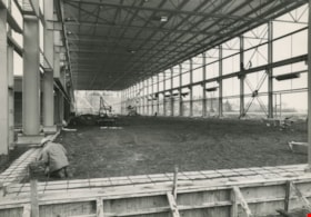
Construction of the Steel Service Centre
https://search.heritageburnaby.ca/link/archivedescription45612
- Repository
- City of Burnaby Archives
- Date
- April 1976
- Collection/Fonds
- Columbian Newspaper collection
- Description Level
- Item
- Physical Description
- 1 photograph : b&w ; 14 x 19.5 cm
- Scope and Content
- Photograph of the construction of the Dominion Bridge Steel Service Centre. Dominion Bridge Co. closed down its Burnaby fabricating plant which employed 350 workers and opened this in Delta which employed only 50 of those workers, putting 300 employess out of work.
- Repository
- City of Burnaby Archives
- Date
- April 1976
- Collection/Fonds
- Columbian Newspaper collection
- Physical Description
- 1 photograph : b&w ; 14 x 19.5 cm
- Description Level
- Item
- Record No.
- 480-506
- Access Restriction
- No restrictions
- Reproduction Restriction
- No restrictions
- Accession Number
- 2003-02
- Scope and Content
- Photograph of the construction of the Dominion Bridge Steel Service Centre. Dominion Bridge Co. closed down its Burnaby fabricating plant which employed 350 workers and opened this in Delta which employed only 50 of those workers, putting 300 employess out of work.
- Names
- Dominion Bridge Company
- Media Type
- Photograph
- Photographer
- King, Basil
- Notes
- Title based on contents of photograph
- Newspaper clipping attached to verso of photograph reads: "More than 600 tons of structural steel are being assembled on Annacis Island to build the new Dominion Bridge Steel Service Centre. Construction which started in the Fall of 1975 will be completed by the end of June."
Images

9886 and 9940 Broadway
https://search.heritageburnaby.ca/link/archivedescription94331
- Repository
- City of Burnaby Archives
- Date
- March 1995
- Collection/Fonds
- Grover, Elliott & Co. Ltd. fonds
- Description Level
- File
- Physical Description
- 70 photographs : col. negatives ; 35 mm
- Scope and Content
- Photographs of Broadway, various residential houses and towers, and undeveloped properties at unidentified locations.
- Repository
- City of Burnaby Archives
- Date
- March 1995
- Collection/Fonds
- Grover, Elliott & Co. Ltd. fonds
- Physical Description
- 70 photographs : col. negatives ; 35 mm
- Description Level
- File
- Record No.
- 622-116
- Access Restriction
- No restrictions
- Reproduction Restriction
- No restrictions
- Accession Number
- 2017-39
- Scope and Content
- Photographs of Broadway, various residential houses and towers, and undeveloped properties at unidentified locations.
- Media Type
- Photograph
- Notes
- Transcribed title
- Title transcribed from envelope photographs were originally housed in
- File no. 95-069-B
- Photographer identified as "K.H."
- Geographic Access
- Broadway
- Street Address
- 9886 Broadway
- 9940 Broadway
- Historic Neighbourhood
- Burquitlam (Historic Neighbourhood)
- Planning Study Area
- Lyndhurst Area