Narrow Results By
Subject
- Advertising Medium - Signs and Signboards 1
- Building Components 8
- Buildings - Commercial - Restaurants 3
- Buildings - Heritage 8
- Clothing 2
- Communication Artifacts 2
- Geographic Features - Roads 2
- Occupations - Civic Workers 2
- Occupations - Teachers 2
- Persons - Children 1
- Persons - Chinese Canadians 1
- Persons - Students 1
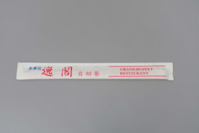
chopsticks
https://search.heritageburnaby.ca/link/museumartifact45241
- Repository
- Burnaby Village Museum
- Accession Code
- BV003.2.1
- Description
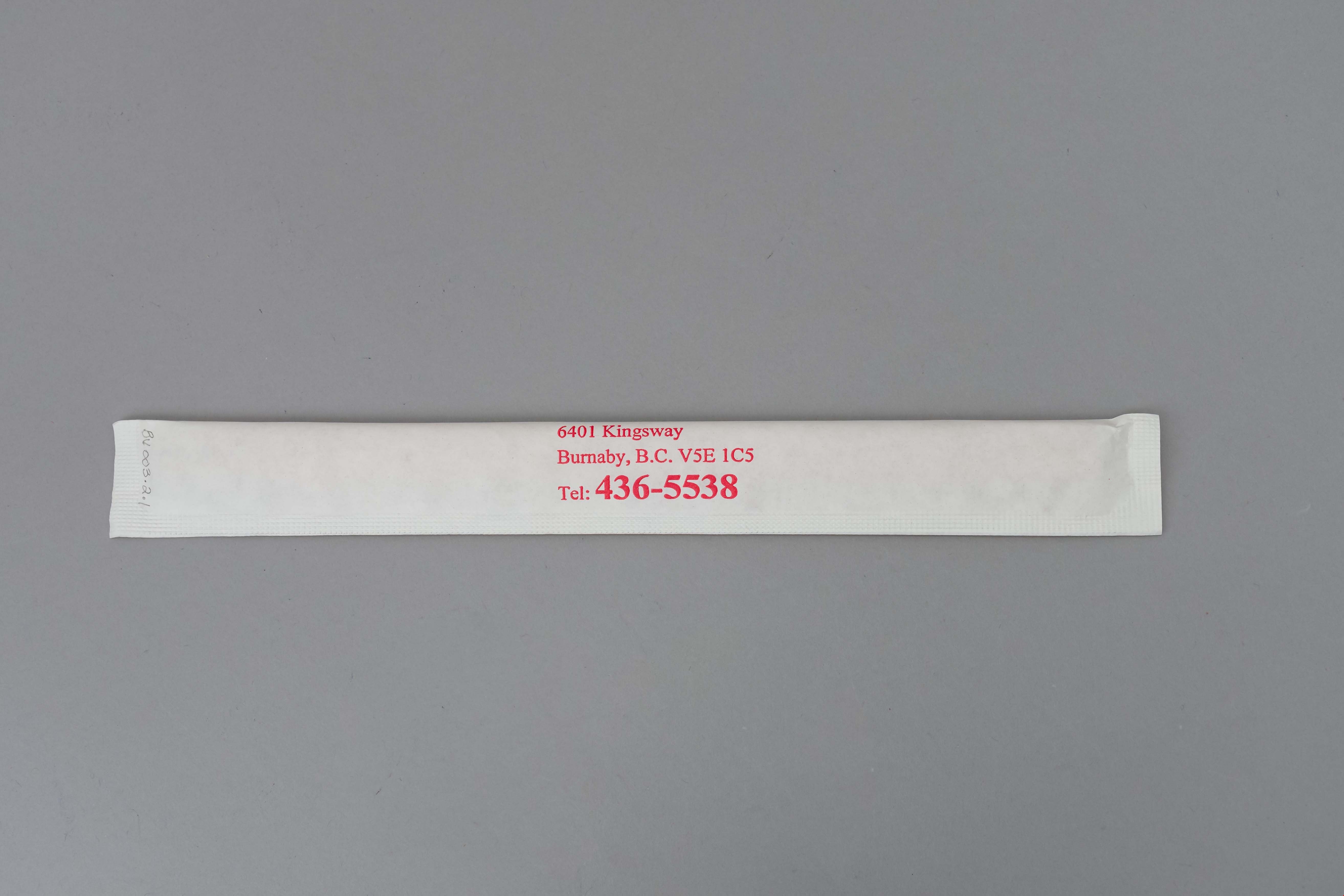
- Pair of wooden chopsticks in white paper package, from the "GRAND BUFFET RESTAURANT", 6041 Kingsway, Burnaby, B.C., V5E 1C5; "Tel: 436-5538"; all lettering in red, and Chinese characters in blue and red.
- Category
- 04.Tools & Equipment for Materials
- Classification
- Food Service T&E - - Eating & Drinking Utensils
- Object Term
- Chopsticks
- Subjects
- Persons - Chinese Canadians
- Historic Neighbourhood
- Edmonds (Historic Neighbourhood)
- Planning Study Area
- Windsor Area
Images

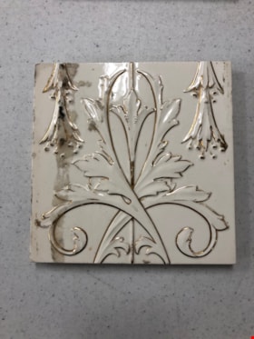
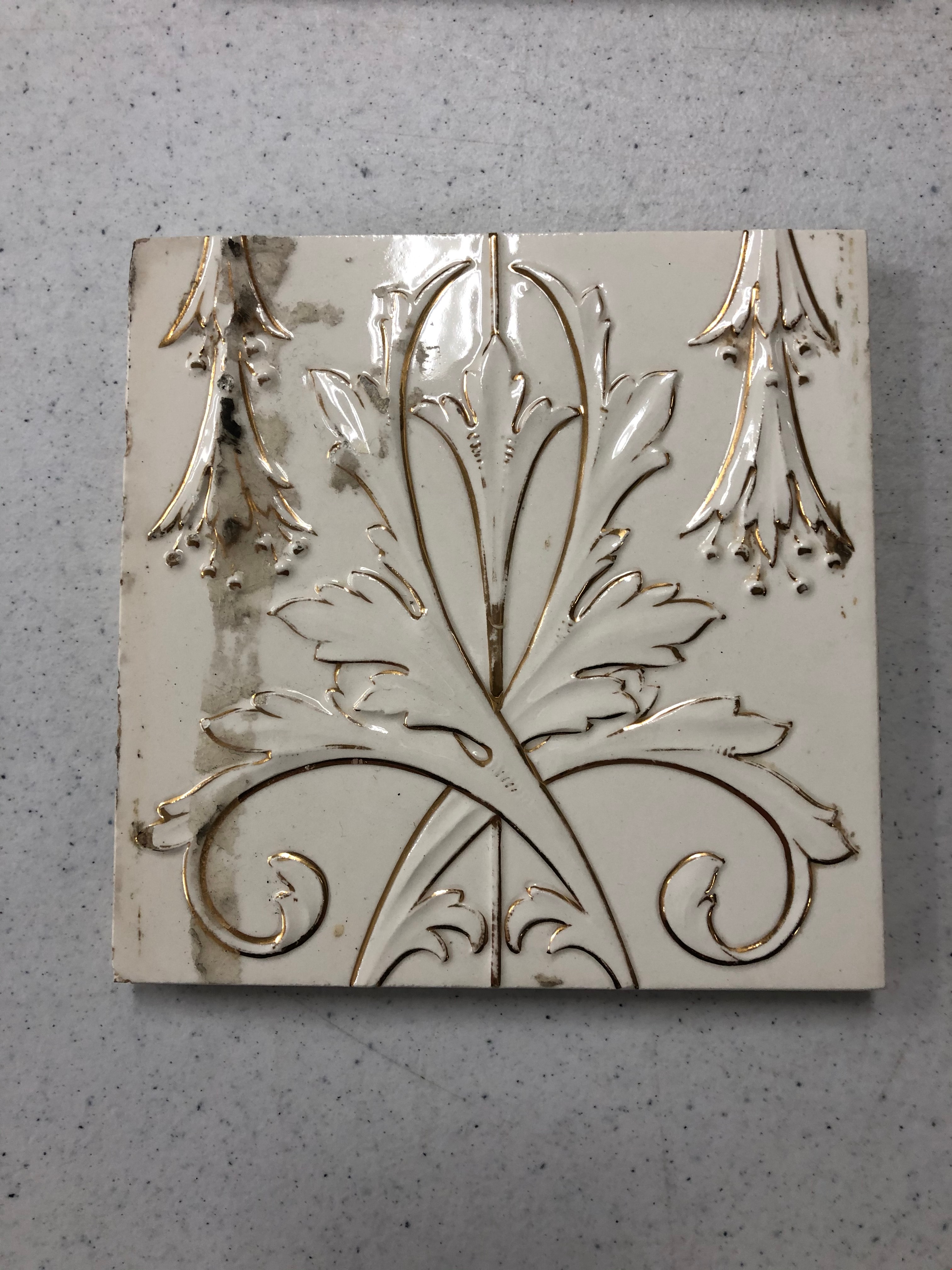
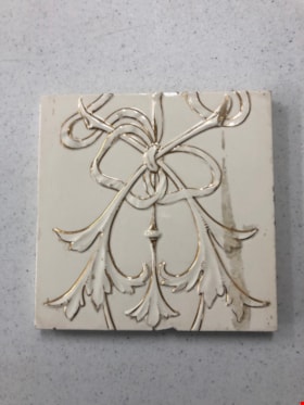
Tile
https://search.heritageburnaby.ca/link/museumartifact90823
- Repository
- Burnaby Village Museum
- Accession Code
- BV020.40.14
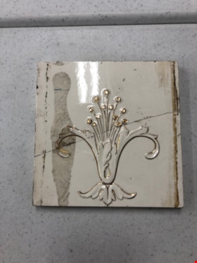
- Description
- White ceramic tile with gold design. The design is made up of a gold line down the centre, and one small flower 3/4 of the way up with two leaves crossed over one another. On either side of the middle design are two trumpeted flowers pointing down from the top of the tile. There is a brown stain all the way down the left handside, over top of the trumpeted flower.
- Object History
- These tiles are from Glenedward Mansion, built in 1912. It was built at 3412 Kingsway, which later became 5152 Kingsway. They were salvaged when the mansion was demolished in the 1990s.
- Category
- 01. Built Environment Objects
- Classification
- Building Components - - Surface Elements
- Object Term
- Tile, Decorative
- Colour
- White
- Gold
- Measurements
- 6" x 6"
- Subjects
- Building Components
- Buildings - Heritage
- Historic Neighbourhood
- Edmonds (Historic Neighbourhood)
- Planning Study Area
- Windsor Area
Images
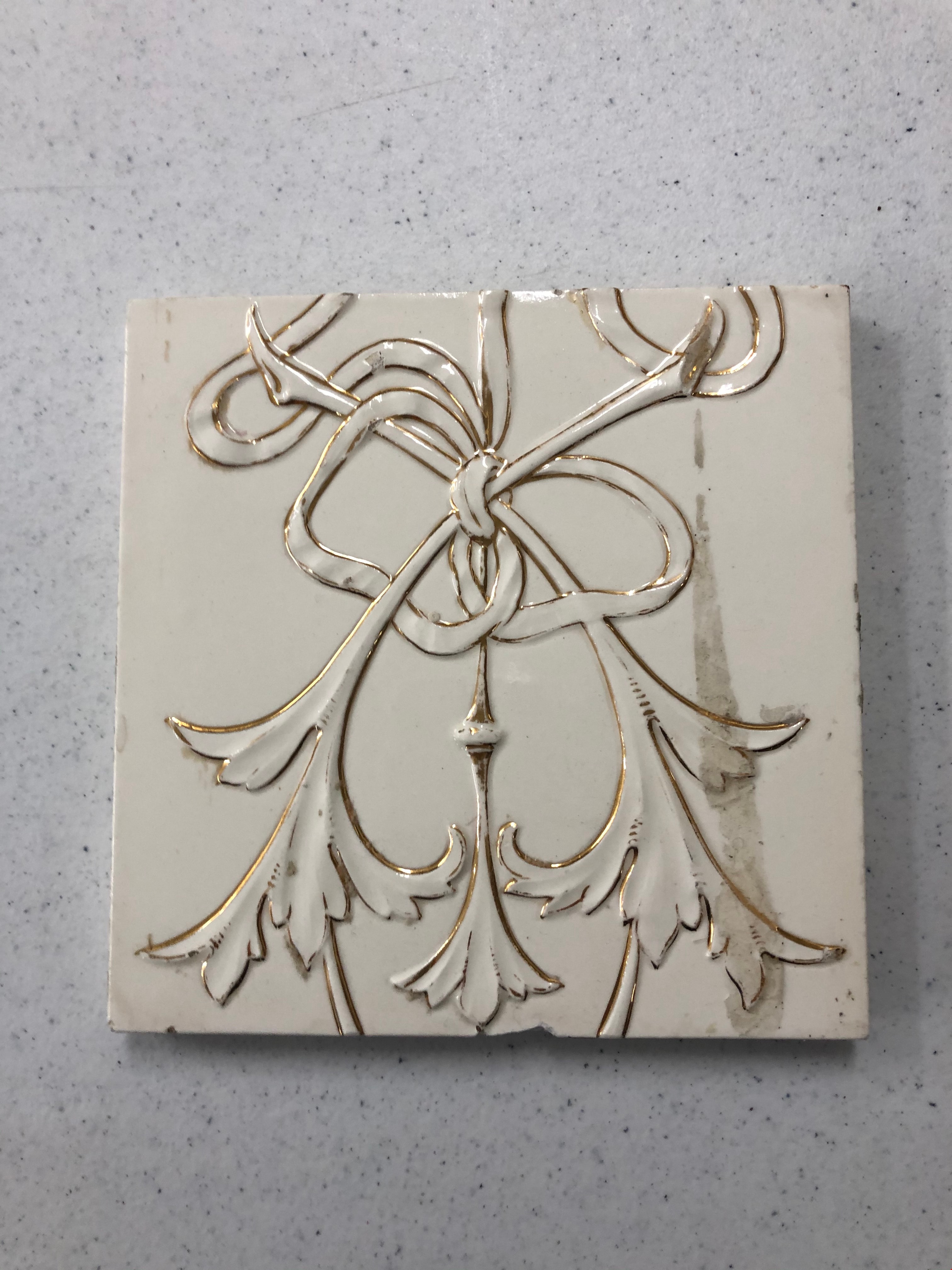
Tile
https://search.heritageburnaby.ca/link/museumartifact90824
- Repository
- Burnaby Village Museum
- Accession Code
- BV020.40.15
- Description
- White ceramic tile with gold design. The design is made up of a a gold line down the centre and a flower at the bottom of that line. Two leaves are tied in a bow around the centre line. There is a brown stain down most of the right hand side.
- Object History
- These tiles are from Glenedward Mansion, built in 1912. It was built at 3412 Kingsway, which later became 5152 Kingsway. They were salvaged when the mansion was demolished in the 1990s.
- Category
- 01. Built Environment Objects
- Classification
- Building Components - - Surface Elements
- Object Term
- Tile, Decorative
- Colour
- White
- Gold
- Measurements
- 6" x 6"
- Subjects
- Building Components
- Buildings - Heritage
- Historic Neighbourhood
- Edmonds (Historic Neighbourhood)
- Planning Study Area
- Windsor Area
Images
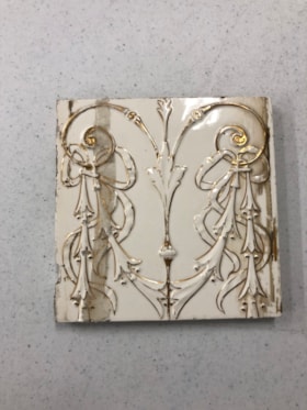
Tile
https://search.heritageburnaby.ca/link/museumartifact90825
- Repository
- Burnaby Village Museum
- Accession Code
- BV020.40.16
- Description
- White ceramic tile with gold design. The design is made up of a gold line down the centre with a leaf comprising the top half. Two gold curls emerge from either side of the line. Six bell-shaped flowers hang from these gold curls on each side and are tied with a ribbon. There is a brown stain down either side.
- Object History
- These tiles are from Glenedward Mansion, built in 1912. It was built at 3412 Kingsway, which later became 5152 Kingsway. They were salvaged when the mansion was demolished in the 1990s.
- Category
- 01. Built Environment Objects
- Classification
- Building Components - - Surface Elements
- Object Term
- Tile, Decorative
- Colour
- White
- Gold
- Measurements
- 6" x 6"
- Subjects
- Building Components
- Buildings - Heritage
- Historic Neighbourhood
- Edmonds (Historic Neighbourhood)
- Planning Study Area
- Windsor Area
Images
Tile
https://search.heritageburnaby.ca/link/museumartifact90826
- Repository
- Burnaby Village Museum
- Accession Code
- BV020.40.17
- Description
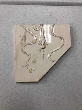
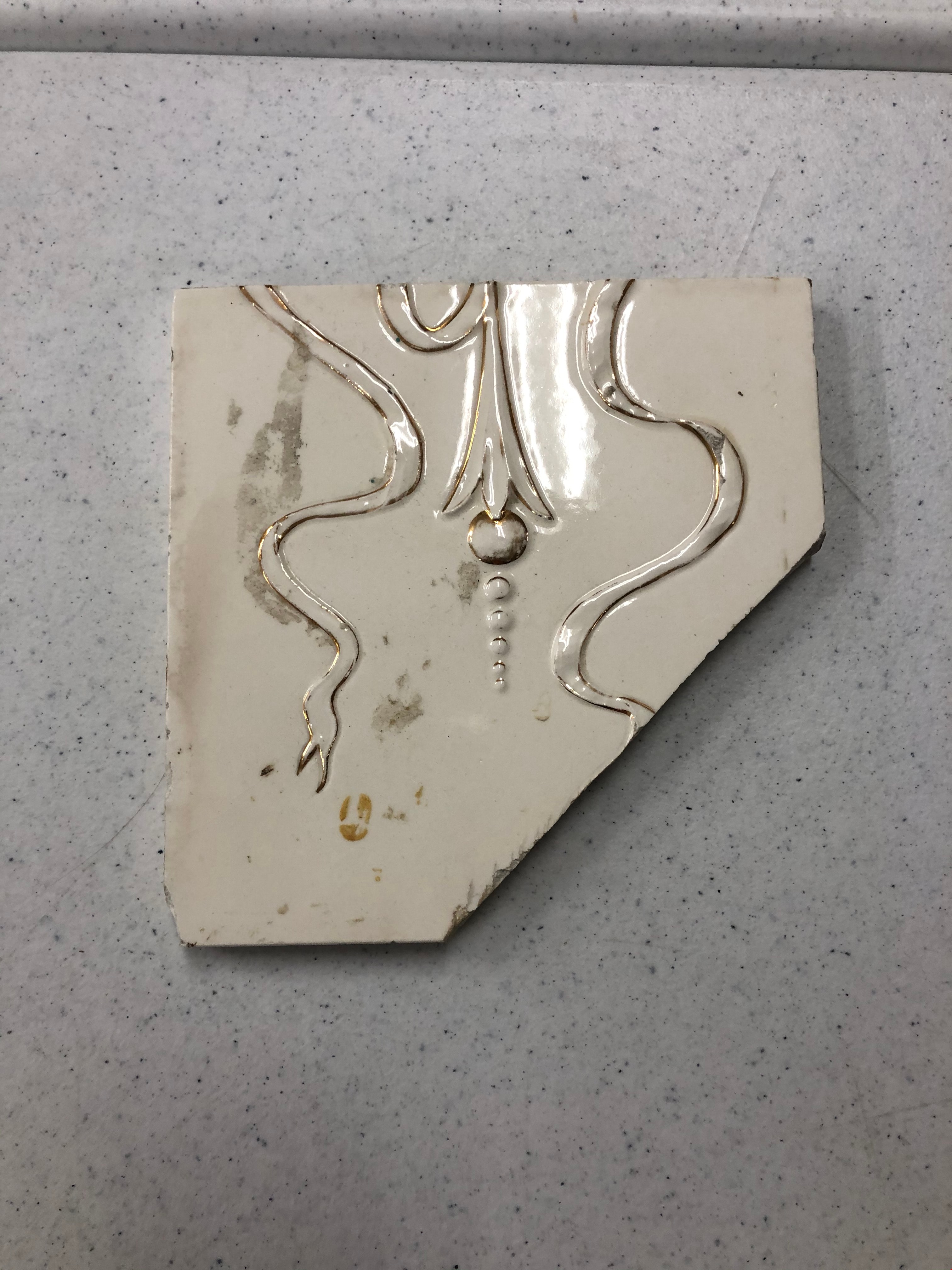
- White ceramic tile with gold design. The design is made up of a gold flower hanging down the centre with six circles coming from the opening of the bell shape. There are two tendrils of ribbon framing either side of the flower in an "S" shape. One end of the ribbon is cut like the end of a snake's tongue. There is a clean diagonal break, nearly a quarter of the whole tile.
- Object History
- These tiles are from Glenedward Mansion, built in 1912. It was built at 3412 Kingsway, which later became 5152 Kingsway. They were salvaged when the mansion was demolished in the 1990s.
- Category
- 01. Built Environment Objects
- Classification
- Building Components - - Surface Elements
- Object Term
- Tile, Decorative
- Measurements
- 6" x 6"
- Subjects
- Building Components
- Buildings - Heritage
- Historic Neighbourhood
- Edmonds (Historic Neighbourhood)
- Planning Study Area
- Windsor Area
Images
Tile
https://search.heritageburnaby.ca/link/museumartifact90827
- Repository
- Burnaby Village Museum
- Accession Code
- BV020.40.18
- Description
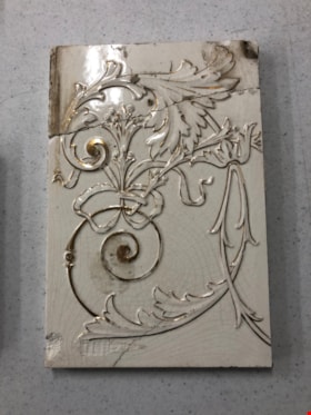
- White ceramic tile with gold design. The design is made up of one flower with two petals curled and splaying out to the right and left side, with two smaller petals in the centre. The flower is resting on a decorative leaf design at the base of the tile. Thirteen stamens with round tips are coming out of the flower. There is a brown stain down the left hands side. There is a clean diagonal break through the middle of the tile.
- Object History
- These tiles are from Glenedward Mansion, built in 1912. It was built at 3412 Kingsway, which later became 5152 Kingsway. They were salvaged when the mansion was demolished in the 1990s.
- Category
- 01. Built Environment Objects
- Classification
- Building Components - - Surface Elements
- Object Term
- Tile, Decorative
- Colour
- White
- Gold
- Measurements
- 6" x 6"
- Subjects
- Building Components
- Buildings - Heritage
- Historic Neighbourhood
- Edmonds (Historic Neighbourhood)
- Planning Study Area
- Windsor Area
Images

Tile
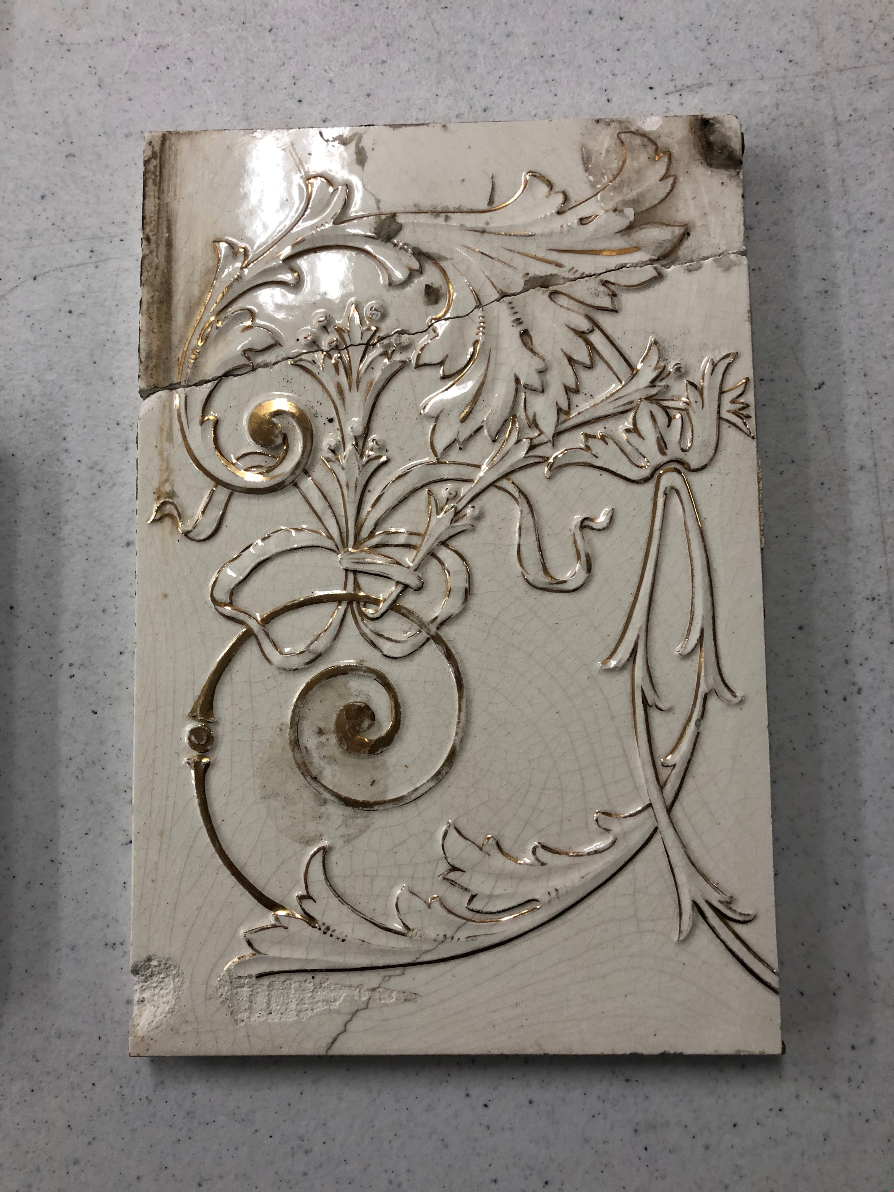
https://search.heritageburnaby.ca/link/museumartifact90830
- Repository
- Burnaby Village Museum
- Accession Code
- BV020.40.19
- Description
- White ceramic tile with gold design. The design is made up of two flowers attached to a gold curled tendril. At the top, a large flower follows the curled line. the line conitnues out of the centre of the flower and splits into two leafy tendrils. One of the leaves has a thick gold curl coming from it. A ribbon with a flower is tied to this gold curl (nearest to the bottom of the tile), and has six stamens coming from the flower. The tile has a wiggled split in the top quarter of the tile, bisecting the large flower.
- Object History
- These tiles are from Glenedward Mansion, built in 1912. It was built at 3412 Kingsway, which later became 5152 Kingsway. They were salvaged when the mansion was demolished in the 1990s.
- Category
- 01. Built Environment Objects
- Classification
- Building Components - - Surface Elements
- Object Term
- Tile, Decorative
- Colour
- White
- Gold
- Measurements
- 8" h x 6" w
- Subjects
- Building Components
- Buildings - Heritage
- Historic Neighbourhood
- Edmonds (Historic Neighbourhood)
- Planning Study Area
- Windsor Area
Images

Tile
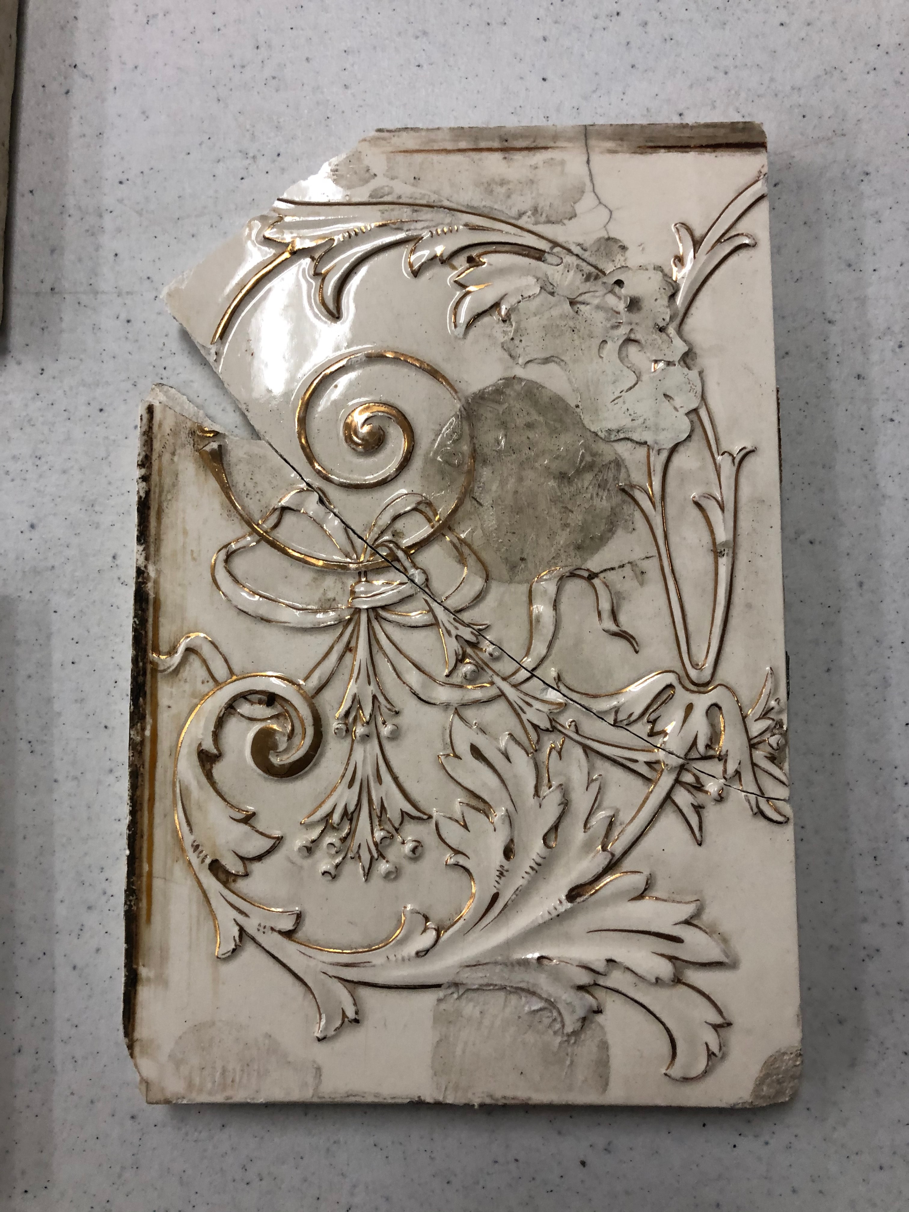
https://search.heritageburnaby.ca/link/museumartifact90833
- Repository
- Burnaby Village Museum
- Accession Code
- BV020.40.20
- Description
- White ceramic tile with gold design. The design is made up of two flowers attached to a gold curled tendril. At the top, a large flower follows the curled line. the line conitnues out of the centre of the flower and splits into two leafy tendrils. One of the leaves has a thick gold curl coming from it. A ribbon with a flower is tied to this gold curl (nearest to the bottom of the tile), and has six stamens coming from the flower. There is a large brown circular stain and lots of gray stains, the colour of dry wall putty. The tile has a clean diagonal split across the centre right near to where the ribbon attaches to the gold curl. The bottom corner is missing with another clean diagonal split, and small triangular piece missing along the largest split.
- Object History
- These tiles are from Glenedward Mansion, built in 1912. It was built at 3412 Kingsway, which later became 5152 Kingsway. They were salvaged when the mansion was demolished in the 1990s.
- Category
- 01. Built Environment Objects
- Classification
- Building Components - - Surface Elements
- Object Term
- Tile, Decorative
- Colour
- White
- Gold
- Measurements
- 8" h x 6" w
- Subjects
- Building Components
- Buildings - Heritage
- Historic Neighbourhood
- Edmonds (Historic Neighbourhood)
- Planning Study Area
- Windsor Area
Images
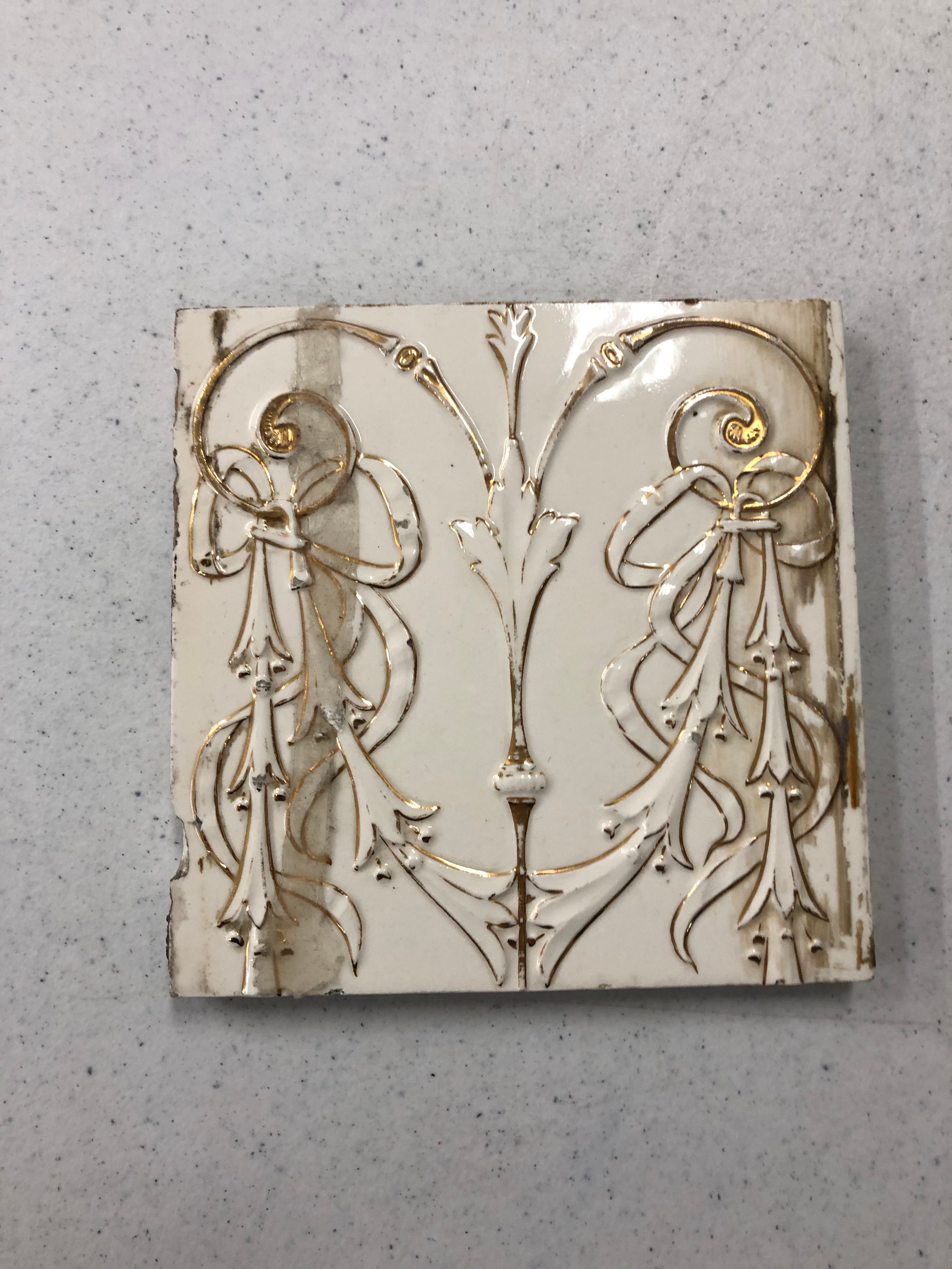
Tile
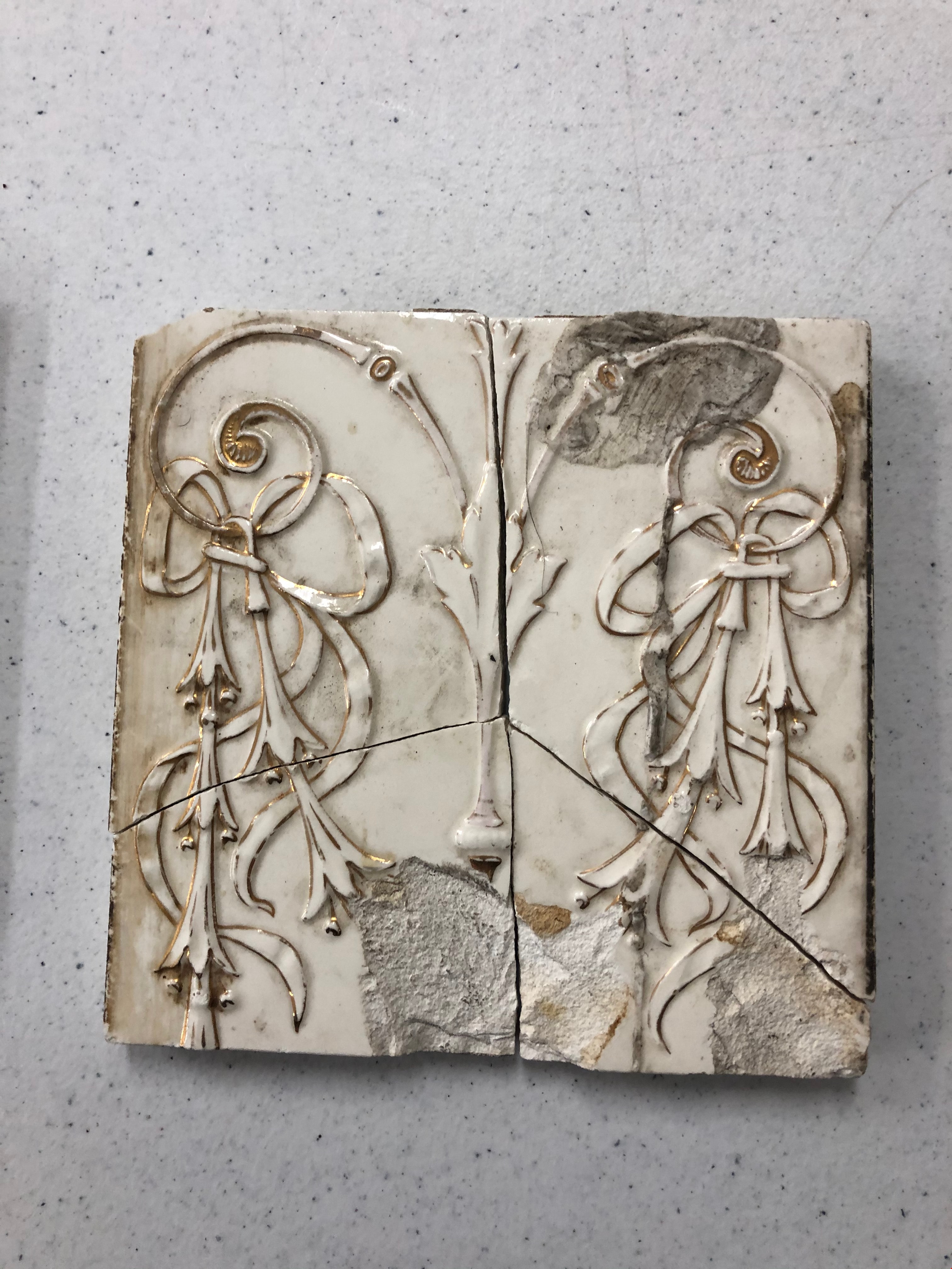
https://search.heritageburnaby.ca/link/museumartifact90836
- Repository
- Burnaby Village Museum
- Accession Code
- BV020.40.21
- Description
- White ceramic tile with gold design. The design is made up of a gold line down the centre with a leaf comprising the top half. Two gold curls emerge from either side of the line. Six bell-shaped flowers hang from these gold curls on each side and are tied with a ribbon. There is a large brown stain on the top right corner with two rough chips out of the bottom. This tile is split into nearly 4 equal parts.
- Object History
- These tiles are from Glenedward Mansion, built in 1912. It was built at 3412 Kingsway, which later became 5152 Kingsway. They were salvaged when the mansion was demolished in the 1990s.
- Category
- 01. Built Environment Objects
- Classification
- Building Components - - Surface Elements
- Object Term
- Tile, Decorative
- Colour
- White
- Gold
- Measurements
- 6" x 6"
- Subjects
- Building Components
- Buildings - Heritage
- Historic Neighbourhood
- Edmonds (Historic Neighbourhood)
- Planning Study Area
- Windsor Area
Images
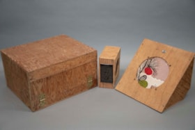
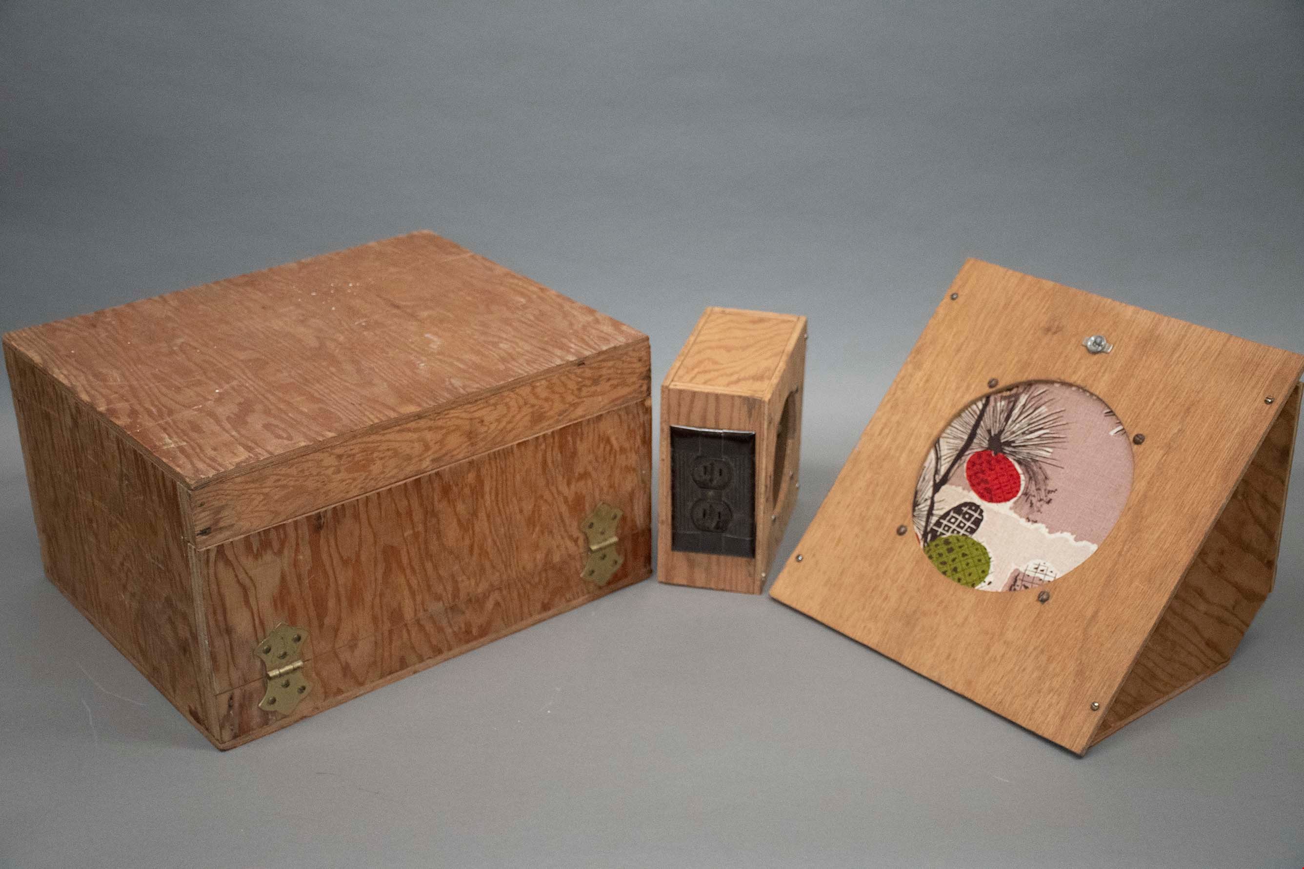
audio amplification set
https://search.heritageburnaby.ca/link/museumartifact91427
- Repository
- Burnaby Village Museum
- Accession Code
- BV021.22.1
- Description
- A large box containing a audio-amp, a wooden triangular prism with a decorative round speaker, and six smaller rectangular boxes. All are made of a light wood, and have different functions.
- Object History
- This audio-amplifier set was used by Mr. Edward A. Fountain, who was appointed as Civil Defense Coordinator on May 5th, 1952. He also built the wooden boxes which contain each part of the set. The Burnaby Civil Defense Department was established in order to disseminate information guiding the public on how to react in response to the impending threat of nuclear war and Russian bombers. In the early 1950’s, this education centered primarily on evacuation, as members of the public were expected to prepare and essentially fend for themselves in the event of a nuclear attack. These pieces of audio technology are believed to have been used at Civil Defense rallies in Burnaby, which Edward Fountain would have been involved in as the department director. According to Burnaby City Council meeting records, music and defense operation demonstrations were commonplace at such rallies, and are examples of what this set was used for.
- Classification
- Telecommunication T&E - - Telecommunication Devices
- Object Term
- Radio
- Colour
- Brown
- Country Made
- Canada
- Province Made
- British Columbia
- Site/City Made
- Burnaby
- Subjects
- Communication Artifacts
- Names
- Fountain, Edward
- Geographic Access
- Burnaby Lake
- Planning Study Area
- Windsor Area
Images
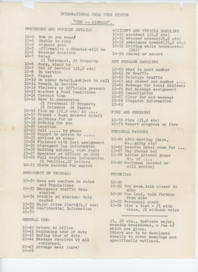
international call codes paper
https://search.heritageburnaby.ca/link/museumartifact91450
- Repository
- Burnaby Village Museum
- Accession Code
- BV021.22.2
- Description
- Paper listing several radio signals used by the Civil Defense department. Paper is creased and yellowing especially around edges and folds.
- Object History
- This “Ten – Signals” paper was donated alongside the audio-amplification set, belonging to Mr. Edward Fountain. The signals represented on the paper were used in training volunteers in the Burnaby Civil Defence Department, of which Mr. Fountain was named Director/ Coordinator in 1952. The Burnaby Civil Defense Department was established in order to disseminate information guiding the public on how to react in response to the impending threat of nuclear war and Russian bombers. In the early 1950’s, this education centered primarily on evacuation, as members of the public were expected to prepare and essentially fend for themselves in the event of a nuclear attack. Training took place throughout the City of Burnaby and in the surrounding regions, as the Civil Defence departments of several municipalities (namely the City of Vancouver and the City of New Westminster) partnered together in evacuation and recovery training, where the use of instructional training papers such as this would come into play.
- Category
- 08. Communication Artifacts
- Classification
- Visual Communication T&E
- Object Term
- Paperwork
- Colour
- White
- Measurements
- height: 28.2 cm width: 22 cm
- Subjects
- Communication Artifacts
- Names
- Fountain, Edward
- Geographic Access
- Burnaby Lake
- Planning Study Area
- Windsor Area
Images
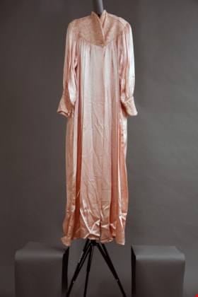
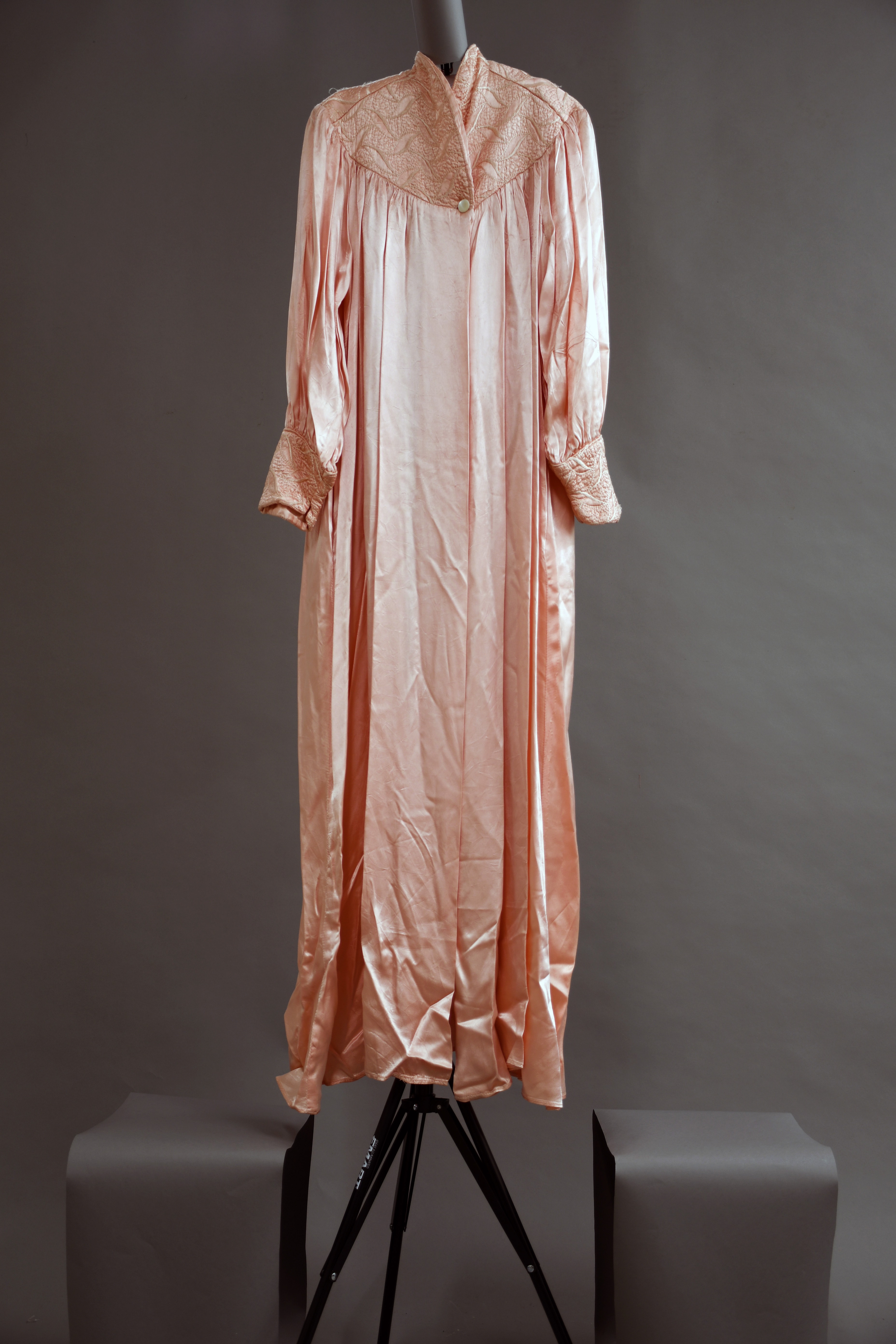
dressing gown
https://search.heritageburnaby.ca/link/museumartifact91459
- Repository
- Burnaby Village Museum
- Accession Code
- BV021.24.1
- Description
- Long pleated satin pink dressing gown with quilted detailing around the collar and cuffs. Detailing has white stitching. There is a small white button at the centre bottom of the collar area to close the robe.
- Object History
- This robe belonged to Mrs. Edith Fountain, nee Ford, wife of Mr. Edward Fountain.
- Category
- 03. Personal Artifacts
- Classification
- Clothing - - Dressingwear & Nightwear
- Object Term
- Dressing Gown
- Colour
- Pink
- Measurements
- height: 136 cm width: 45 cm depth: 5.5 cm
- Subjects
- Clothing
- Names
- Fountain, Edith Ford
- Historic Neighbourhood
- Central Park (Historic Neighbourhood)
- Planning Study Area
- Windsor Area
Images

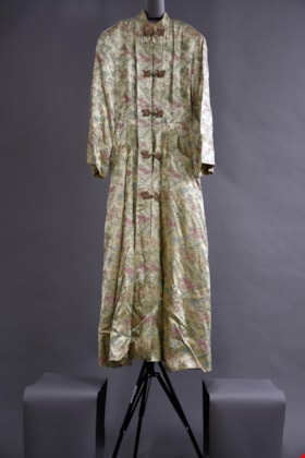
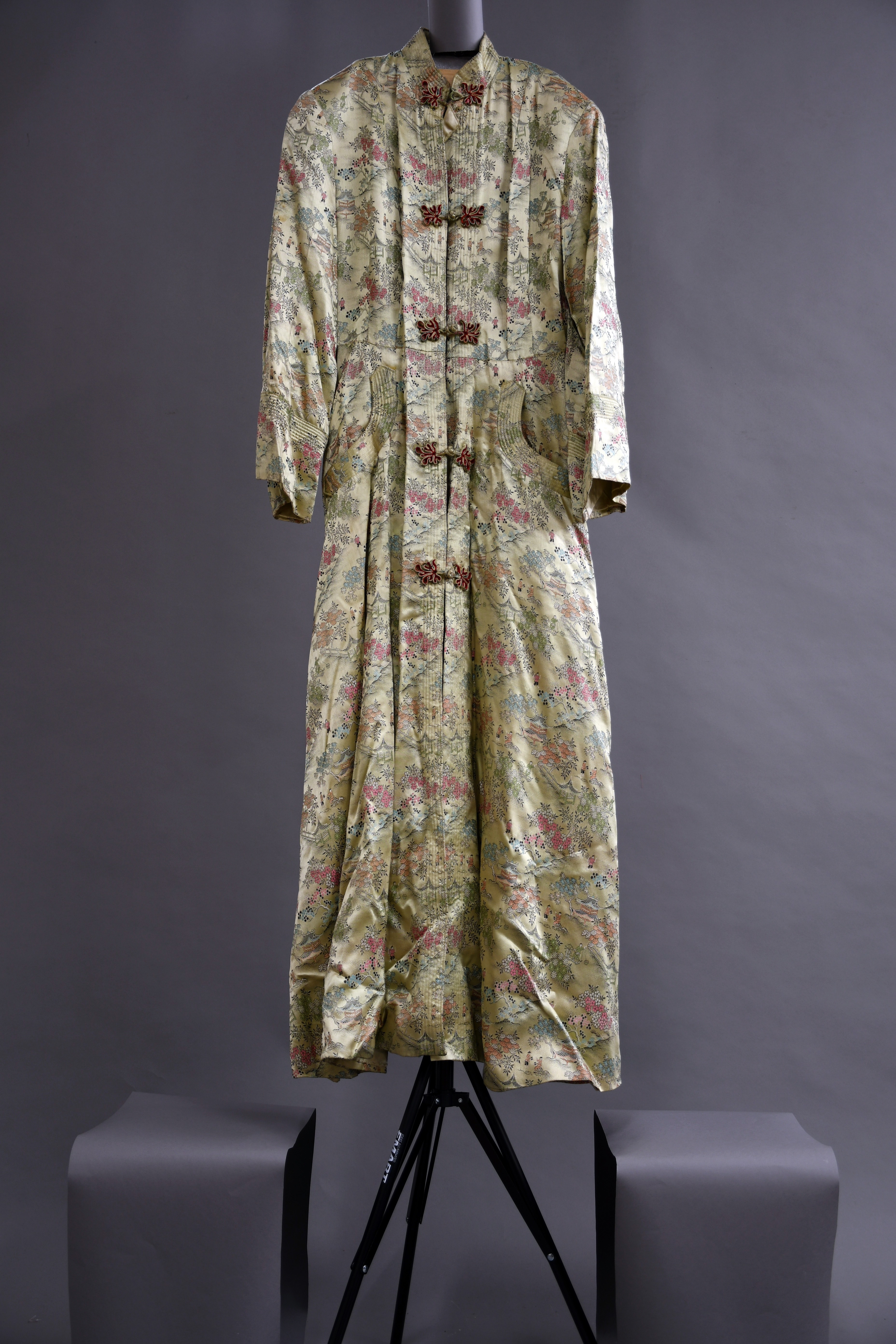
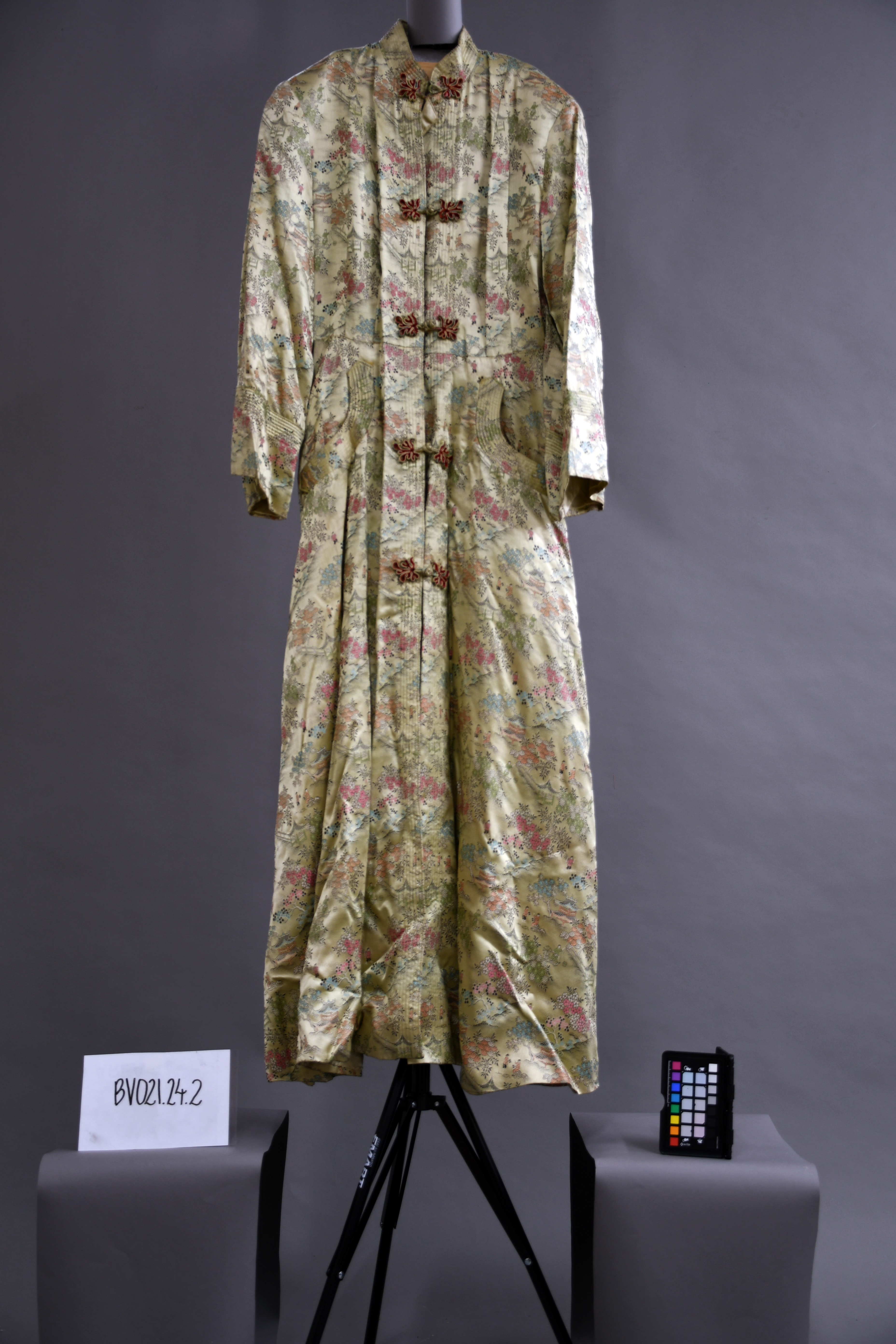
dressing gown
https://search.heritageburnaby.ca/link/museumartifact91496
- Repository
- Burnaby Village Museum
- Accession Code
- BV021.24.2
- Description
- A long beige dressing gown with buttons down the front. The structure and pattern immitate the design of a traditional japanese kimono, as the embroidered design shows several "japanese scenes" including buildings, flora, and small figures.
- Object History
- This robe belonged to Mrs. Edith Fountain, nee Ford, wife of Mr. Edward Fountain.
- Category
- 03. Personal Artifacts
- Classification
- Clothing - - Dressingwear & Nightwear
- Object Term
- Dressing Gown
- Colour
- Beige
- Measurements
- height: 141 cm width: 48 cm depth: 5.5 cm
- Country Made
- Hong Kong
- Subjects
- Clothing
- Names
- Fountain, Edith Ford
- Historic Neighbourhood
- Central Park (Historic Neighbourhood)
- Planning Study Area
- Windsor Area
Images
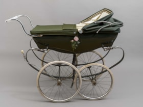
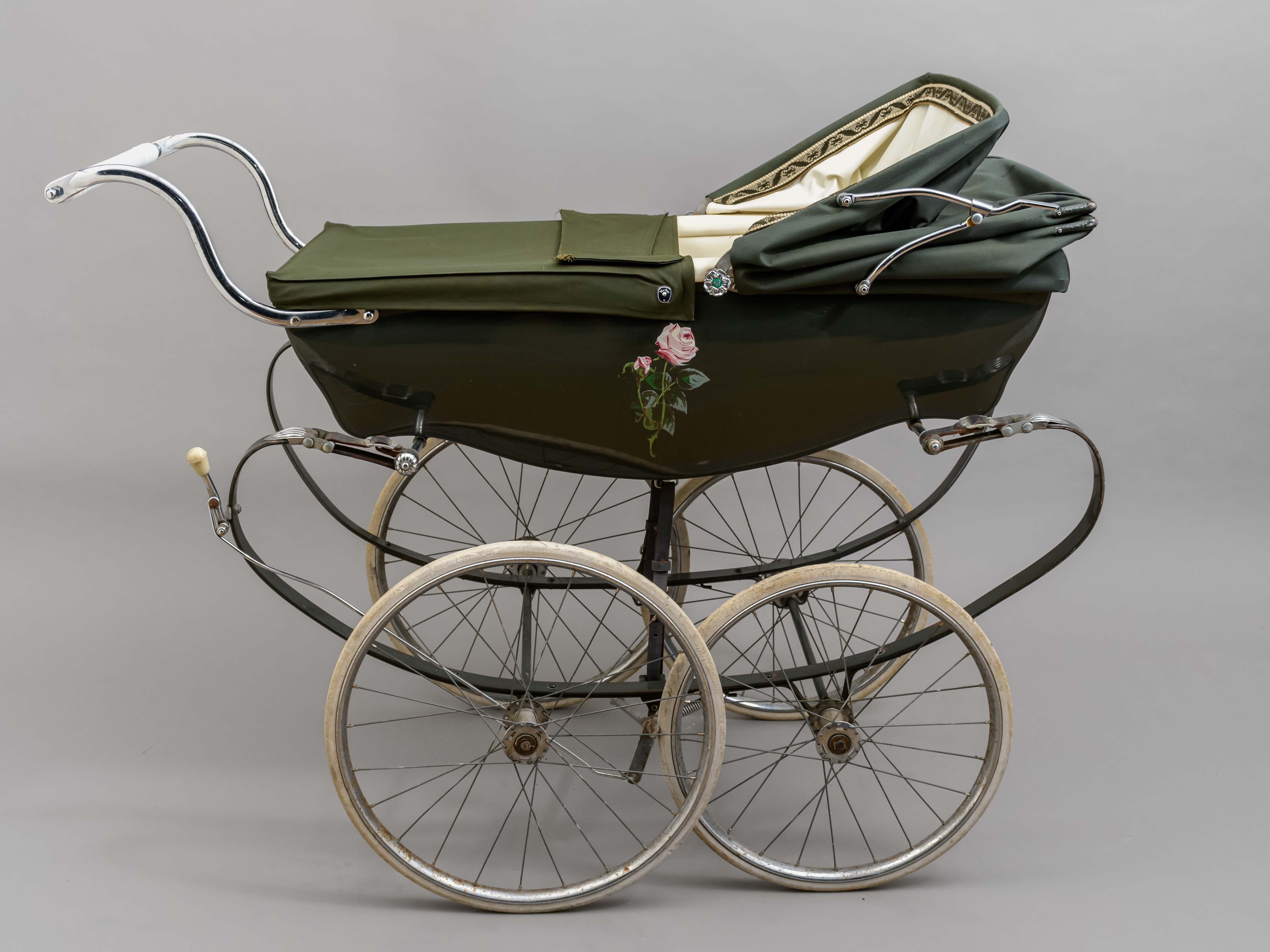
pram
https://search.heritageburnaby.ca/link/museumartifact91514
- Repository
- Burnaby Village Museum
- Accession Code
- BV021.30.1
- Description
- Green classic Wilson brand pram. There are four narrow wheels, a low-set handle bar and a moveable top canopy and cover with a patterned interior trim. The interior of the pram is white, as is the handlebar, brake handle and wheel covers. On the front end, there is a logo with the brand "Wilson" written in silver cursive, a narrow British flag and a blue tag indicating "Made in England". On either side of the pram, there is a painted pink rose. The knobs on either side of the canopy are also made to look like silver roses, with a yellow and green "W" symbol in their centre.
- Object History
- This pram belonged to George and Elaine (nee Blackstock) Burnett who lived in Burnaby on Elgin Avenue. The couple had four children, but the exact timeline of when this pram was used in unknown. The pram was made in England by the company Silver Cross, which was founded by William Wilson in 1877. It is the founder's surname from which the pram derives its name, which is found on the end of the carriage. George Burnett was employed as the foreman plumber at Oakalla Prison in Burnaby for 30 years. He was also the President of the Royal Canadian Legion Branch 83 in Burnaby. Elaine's family farmed on land in the Deer Lake Area. George and Elaine had four children: John, Derek, Louise, and Lori.
- Reference
- Pioneer Tales of Burnaby, the Corporation of the District of Burnaby: Part III: 1911-1920. Elsie Dawkins Norman. Burnaby Village Museum, Digital Reference Collection. Published 1987. (page 333)
- Classification
- Land Transportation T&E - - Human-Powered Vehicles
- Object Term
- Stroller
- Marks/Labels
- Painted pink roses; Wilson label; Made in England
- Colour
- Green
- Measurements
- height: 100 cm width: 55 cm depth: 124 cm
- Country Made
- England
- Subjects
- Transportation
- Historic Neighbourhood
- Central Park (Historic Neighbourhood)
- Planning Study Area
- Windsor Area
Images
![Kingsway, [1914] thumbnail](/media/hpo/_Data/_BVM_Images/1971/197200110022.jpg?width=280)
Kingsway
https://search.heritageburnaby.ca/link/museumdescription3108
- Repository
- Burnaby Village Museum
- Date
- [1914]
- Collection/Fonds
- Burnaby Village Museum Photograph collection
- Description Level
- Item
- Physical Description
- 1 photograph : b&w glass negative ; 15.8 x 21.1 cm
- Scope and Content
- Photograph of a paved street lined on both sides with curbs and electric poles. There appears to be a car in the distance, as well as an idustrial building on the right-hand side of the road. An earlier catalogue record from 1988 conjectures that the street is Kingsway, probably in Burnaby, between…
- Repository
- Burnaby Village Museum
- Collection/Fonds
- Burnaby Village Museum Photograph collection
- Description Level
- Item
- Physical Description
- 1 photograph : b&w glass negative ; 15.8 x 21.1 cm
- Scope and Content
- Photograph of a paved street lined on both sides with curbs and electric poles. There appears to be a car in the distance, as well as an idustrial building on the right-hand side of the road. An earlier catalogue record from 1988 conjectures that the street is Kingsway, probably in Burnaby, between Sperling Avenue and Royal Oak, looking South, and that the building is possibly the Macadam making plant for the company which paved Kingsway.
- Subjects
- Geographic Features - Roads
- Geographic Access
- Kingsway
- Sperling Avenue
- Royal Oak Avenue
- Accession Code
- HV972.11.22
- Access Restriction
- No restrictions
- Reproduction Restriction
- No known restrictions
- Date
- [1914]
- Media Type
- Photograph
- Planning Study Area
- Windsor Area
- Scan Resolution
- 300
- Scan Date
- 14/8/2006
- Scale
- 100
- Notes
- Title based on contents of photograph
- 1 b&w contact print accompanying negative
Images
![Kingsway, [1914] thumbnail](/media/hpo/_Data/_BVM_Images/1971/197200110022.jpg)
![Entrance to Oasis Tourist Camp, [192-] thumbnail](/media/hpo/_Data/_BVM_Images/1977/1977_0121_0003_001.jpg?width=280)
Entrance to Oasis Tourist Camp
https://search.heritageburnaby.ca/link/museumdescription594
- Repository
- Burnaby Village Museum
- Date
- [192-]
- Collection/Fonds
- Roy Bernard Raymer fonds
- Description Level
- Item
- Physical Description
- 1 photograph : sepia ; 8.6 x 15.1 cm
- Scope and Content
- Photograph of the entrance to Oasis Tourist Camp, which is marked by a large sign put up with two posts on either side of the sign . It reads, "Tea Gardens / The Oasis / 'Rest and Refresh' / Free Tourist Camp." Further along the driveway is a smaller sign that reads: "'Welcome.' Drive In." To the…
- Repository
- Burnaby Village Museum
- Collection/Fonds
- Roy Bernard Raymer fonds
- Description Level
- Item
- Physical Description
- 1 photograph : sepia ; 8.6 x 15.1 cm
- Scope and Content
- Photograph of the entrance to Oasis Tourist Camp, which is marked by a large sign put up with two posts on either side of the sign . It reads, "Tea Gardens / The Oasis / 'Rest and Refresh' / Free Tourist Camp." Further along the driveway is a smaller sign that reads: "'Welcome.' Drive In." To the left of the entrance is a modified house building with a sign advertising for Fraser Valley ice cream placed outside the extended patio. The Oasis Tourist Camp was located at 2675 Kingsway (after 1959 address became 6105 Kingsway) in Burnaby and was owned and operated by the Raymer family.
- Names
- Oasis
- Geographic Access
- Kingsway
- Street Address
- 6105 Kingsway
- Accession Code
- HV977.121.3
- Access Restriction
- No restrictions
- Reproduction Restriction
- No known restrictions
- Date
- [192-]
- Media Type
- Photograph
- Planning Study Area
- Windsor Area
- Scan Resolution
- 600
- Scan Date
- 23-Aug-06
- Scale
- 100
- Notes
- Title based on contents of photograph
Images
![Entrance to Oasis Tourist Camp, [192-] thumbnail](/media/hpo/_Data/_BVM_Images/1977/1977_0121_0003_001.jpg)
Burnaby South School yearbook : 1925-1926
https://search.heritageburnaby.ca/link/museumlibrary7508
- Repository
- Burnaby Village Museum
- Collection
- Special Collection
- Material Type
- Book
- Accession Code
- BV020.7.1
- Call Number
- 373.71 BUR 1926
- Place of Publication
- Burnaby, B.C.
- Publisher
- Burnaby South Secondary School
- Publication Date
- 1926
- Printer
- Lionel Ward & Co. Ltd.
- Inscription
- "Loretta S. Roberts"
- Library Subject (LOC)
- School yearbooks--1920-1929
- Schools--British Columbia--Burnaby
- School yearbooks
- Historic Neighbourhood
- Central Park (Historic Neighbourhood)
- Planning Study Area
- Windsor Area
- Geographic Access
- Rumble Street
- Street Address
- 5455 Rumble Street
- Object History
- This yearbook belonged to Lauretta Roberts.
- Notes
- High school annual for Burnaby South

Municipality of Burnaby - Volume XVIII and Volume XIX
https://search.heritageburnaby.ca/link/museumdescription8683
- Repository
- Burnaby Village Museum
- Date
- May 1927
- Collection/Fonds
- Burnaby Village Museum Map collection
- Description Level
- File
- Physical Description
- 2 plans on 2 sheets : col. lithographic prints ; 63.5 x 53.5 cm folded to 53 x 31.5 cm
- Scope and Content
- File consists of two pages of plans removed from a bound book containing a series of fire insurance plans of the Municipality of Burnaby. Plan "1832" is from "GREATER VANCOUVER B.C. / VOLUME XVIII / Municipality of Burnaby / May, 1927" and covers District Lots: 98 and 28. Plan "K" is part of a key …
- Repository
- Burnaby Village Museum
- Collection/Fonds
- Burnaby Village Museum Map collection
- Description Level
- File
- Physical Description
- 2 plans on 2 sheets : col. lithographic prints ; 63.5 x 53.5 cm folded to 53 x 31.5 cm
- Material Details
- Scale [1:1200] to [1:6000]
- Scope and Content
- File consists of two pages of plans removed from a bound book containing a series of fire insurance plans of the Municipality of Burnaby. Plan "1832" is from "GREATER VANCOUVER B.C. / VOLUME XVIII / Municipality of Burnaby / May, 1927" and covers District Lots: 98 and 28. Plan "K" is part of a key plan "GREATER VANCOUVER B.C. / Surveyed VOLUME XIX May 1927 / MUNICIPALITY OF / BURNABY / PLAN DEPT. British Columbia Ins. Underwriters Association / FIRE BRANCH / KEY PLAN", "Scale 500 FT = 1 INCH / FOR REPORT SEE VOL. XV" covering plans: 1901 to 1914 and District Lots: 161; 164 to 167; 155c; 155; 172 and 173.
- Responsibility
- British Columbia Underwriters' Association
- Accession Code
- HV972.111.5
- Access Restriction
- No restrictions
- Reproduction Restriction
- May be restricted by third party rights
- Date
- May 1927
- Media Type
- Cartographic Material
- Historic Neighbourhood
- East Burnaby (Historic Neighbourhood)
- Central Park (Historic Neighbourhood)
- Fraser Arm (Historic Neighbourhood)
- Alta Vista (Historic Neighbourhood)
- Planning Study Area
- Windsor Area
- Marlborough Area
- Second Street Area
- Big Bend Area
- Sussex-Nelson Area
- Scan Resolution
- 400
- Scan Date
- 2021-11-18
- Notes
- Title based on content of plans
- See also BV987.1.70d for revised versions of plans
- Scale is measured 1 inch = 500 feet
Zoomable Images


Municipality of Burnaby - Volume XV, Volume XVI, Volume XVII, Volume XVIII
https://search.heritageburnaby.ca/link/museumdescription8685
- Repository
- Burnaby Village Museum
- Date
- May 1927
- Collection/Fonds
- Burnaby Village Museum Map collection
- Description Level
- File
- Physical Description
- 4 plans on 4 sheets : col. lithographic prints ; 63.5 x 53.5 cm folded to 53 x 31.5 cm
- Scope and Content
- File consists of four pages of plans removed from a bound book containing a series of fire insurance plans of the Municipality of Burnaby. Plan "1531" is part of "GREATER VANCOUVER B.C. / VOLUME XV / Municipality of Burnaby / May 1927" and covers District Lots: 116 and 117. Key Plan "C" is part of …
- Repository
- Burnaby Village Museum
- Collection/Fonds
- Burnaby Village Museum Map collection
- Description Level
- File
- Physical Description
- 4 plans on 4 sheets : col. lithographic prints ; 63.5 x 53.5 cm folded to 53 x 31.5 cm
- Material Details
- Scale [1:600] and [1:1200]
- Scope and Content
- File consists of four pages of plans removed from a bound book containing a series of fire insurance plans of the Municipality of Burnaby. Plan "1531" is part of "GREATER VANCOUVER B.C. / VOLUME XV / Municipality of Burnaby / May 1927" and covers District Lots: 116 and 117. Key Plan "C" is part of "GREATER VANCOUVER B.C. / VOLUME XVI / Municipality of Burnaby / May 1927" and covers plans 1623 to 1651 and District Lots: 1 and 2; 4; 6; 8; 10 to 14; 25; 27; 40; 56 to 58; 88 and 89. Plan "1738" is part of "GREATER VANCOUVER B.C. / VOLUME XVII / Municipality of Burnaby / May 1927" and covers District Lots: 34 and 35. Key plan "G" is part of "GREATER VANCOUVER B.C. / VOLUME XVIII / Municipality of Burnaby / May 1927" and covers plans: 1801 to 1813; 1823; 1824; 1833 to 1838; 1841 to 1853 and District Lots: 32; 93; 94; 97 to 99; 149; 150; 152; 155 to 159; 161 to 164.
- Responsibility
- British Columbia Underwriters' Association
- Accession Code
- HV972.111.7
- Access Restriction
- No restrictions
- Reproduction Restriction
- May be restricted by third party rights
- Date
- May 1927
- Media Type
- Cartographic Material
- Historic Neighbourhood
- Central Park (Historic Neighbourhood)
- Fraser Arm (Historic Neighbourhood)
- Alta Vista (Historic Neighbourhood)
- Broadview (Historic Neighbourhood)
- Vancouver Heights (Historic Neighbourhood)
- Burquitlam (Historic Neighbourhood)
- East Burnaby (Historic Neighbourhood)
- Edmonds (Historic Neighbourhood)
- Lozells (Historic Neighbourhood)
- Planning Study Area
- Clinton-Glenwood Area
- Marlborough Area
- Maywood Area
- Windsor Area
- Big Bend Area
- Garden Village Area
- Willingdon Heights Area
- West Central Valley Area
- Cariboo-Armstrong Area
- Lyndhurst Area
- Cameron Area
- Lake City Area
- Edmonds Area
- Second Street Area
- Sperling-Broadway Area
- Lakeview-Mayfield Area
- Scan Resolution
- 400
- Scan Date
- 2021-11-18
- Notes
- Title based on content of plans
- See also BV987.1.70d for revised versions of plans
- Scale is measured 1 inch = 500 feet
Zoomable Images

Municipality of Burnaby - Volume XV, Volume XVI, Volume XVII, Volume XVIII, May 1927
Zoom into Image

Municipality of Burnaby- Volume XV and Volume XVIII
https://search.heritageburnaby.ca/link/museumdescription8686
- Repository
- Burnaby Village Museum
- Date
- May 1927
- Collection/Fonds
- Burnaby Village Museum Map collection
- Description Level
- File
- Physical Description
- 4 plans on 4 sheets : col. lithographic prints ; 63.5 x 53.5 cm folded to 53 x 31.5 cm
- Scope and Content
- File consists of four pages of plans removed from a bound book containing a series of fire insurance plans of the Municipality of Burnaby. Plan "1520" is part of "GREATER VANCOUVER B.C. / VOLUME XV / Municipality of Burnaby / May 1927" and covers District Lots: 121 and 187. Plann "1521" is part of …
- Repository
- Burnaby Village Museum
- Collection/Fonds
- Burnaby Village Museum Map collection
- Description Level
- File
- Physical Description
- 4 plans on 4 sheets : col. lithographic prints ; 63.5 x 53.5 cm folded to 53 x 31.5 cm
- Material Details
- Scale [1:600] and [1:1200]
- Scope and Content
- File consists of four pages of plans removed from a bound book containing a series of fire insurance plans of the Municipality of Burnaby. Plan "1520" is part of "GREATER VANCOUVER B.C. / VOLUME XV / Municipality of Burnaby / May 1927" and covers District Lots: 121 and 187. Plann "1521" is part of "GREATER VANCOUVER B.C. / VOLUME XV / Municipality of Burnaby / May 1927" and covers District Lots: 121 and 187. Key plan "H" reads: "GREATER VANCOUVER B.C. / VOLUME XVIII / Surveyed _ May 1927 / MUNICIPALITY OF / BURNABY" and covers plans: 1813 to 1822; 1824 to 1832; 1839; 1840; 1853 to 1865 and District Lots: 28; 30; 53; 90 to 93; 95 to 97; 155a; 155b; 155c; 159; 160; 171 to 173. Plan "1801" is part of "GREATER VANCOUVER B.C. / VOLUME XVIII / Municipality of Burnaby / May 1927" and covers District Lot 153.
- Responsibility
- British Columbia Underwriters' Association
- Accession Code
- HV972.111.8
- Access Restriction
- No restrictions
- Reproduction Restriction
- May be restricted by third party rights
- Date
- May 1927
- Media Type
- Cartographic Material
- Historic Neighbourhood
- Fraser Arm (Historic Neighbourhood)
- Vancouver Heights (Historic Neighbourhood)
- East Burnaby (Historic Neighbourhood)
- Edmonds (Historic Neighbourhood)
- Planning Study Area
- Marlborough Area
- Kingsway-Beresford Area
- Windsor Area
- Big Bend Area
- Clinton-Glenwood Area
- Burnaby Heights Area
- Edmonds Area
- Stride Avenue Area
- Scan Resolution
- 400
- Scan Date
- 2021-11-18
- Notes
- Title based on content of plans
- See also BV987.1.70d for revised versions of plans
- Scale is measured 1 inch = 500 feet
