Narrow Results By
Bus Stop - East Side of Willingdon Avenue North of Lougheed Highway
https://search.heritageburnaby.ca/link/councilreport37197
- Repository
- City of Burnaby Archives
- Report ID
- 33556
- Meeting Date
- 10-Aug-1964
- Format
- Council - Committee Report
- Collection/Fonds
- City Council and Office of the City Clerk fonds
- Repository
- City of Burnaby Archives
- Report ID
- 33556
- Meeting Date
- 10-Aug-1964
- Format
- Council - Committee Report
- Collection/Fonds
- City Council and Office of the City Clerk fonds
Documents
Certificate of Sufficiency - Lighting of Lane Immediately West of Willingdon Avenue North from Wildwood Crescent to the North Property Line of 4463 Cedarwood Court
https://search.heritageburnaby.ca/link/councilreport11592
- Repository
- City of Burnaby Archives
- Report ID
- 12331
- Meeting Date
- 26-Nov-1990
- Format
- Council - Mayor/Councillor/Staff Report
- Collection/Fonds
- City Council and Office of the City Clerk fonds
- Repository
- City of Burnaby Archives
- Report ID
- 12331
- Meeting Date
- 26-Nov-1990
- Format
- Council - Mayor/Councillor/Staff Report
- Collection/Fonds
- City Council and Office of the City Clerk fonds
Documents
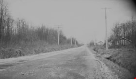
Graveley Street and Willingdon Avenue
https://search.heritageburnaby.ca/link/archivedescription34113
- Repository
- City of Burnaby Archives
- Date
- March 22, 1947
- Collection/Fonds
- Burnaby Historical Society fonds
- Description Level
- Item
- Physical Description
- 1 photograph : b&w negative ; 6.8 x 11.3 cm
- Scope and Content
- Photograph of Graveley Street and Willingdon Avenue (north) with houses along one side and trees and brush along the other side. This is part of the Willingdon Heights subdivision site.
- Repository
- City of Burnaby Archives
- Date
- March 22, 1947
- Collection/Fonds
- Burnaby Historical Society fonds
- Subseries
- Alfred Bingham subseries
- Physical Description
- 1 photograph : b&w negative ; 6.8 x 11.3 cm
- Description Level
- Item
- Record No.
- 010-029
- Access Restriction
- No restrictions
- Reproduction Restriction
- No known restrictions
- Accession Number
- BHS2007-04
- Scope and Content
- Photograph of Graveley Street and Willingdon Avenue (north) with houses along one side and trees and brush along the other side. This is part of the Willingdon Heights subdivision site.
- Subjects
- Geographic Features - Roads
- Media Type
- Photograph
- Photographer
- Bingham, Alfred "Alf"
- Notes
- Title based on contents of photograph
- Geographic Access
- Graveley Street
- Willingdon Avenue
Images
Judi Marshall at Chevron Refinery
https://search.heritageburnaby.ca/link/archivedescription96878
- Repository
- City of Burnaby Archives
- Date
- [2000]
- Collection/Fonds
- Burnaby NewsLeader photograph collection
- Description Level
- Item
- Physical Description
- 1 photograph (tiff) : col.
- Scope and Content
- Photograph of Judi Marshall, a concerned resident of North Burnaby, leaning against the fence of the Chevron Refinery on Willingdon Avenue. Warning signs are on the fence and one of the refinery's tanks is visible.
- Repository
- City of Burnaby Archives
- Date
- [2000]
- Collection/Fonds
- Burnaby NewsLeader photograph collection
- Physical Description
- 1 photograph (tiff) : col.
- Description Level
- Item
- Record No.
- 535-2436
- Access Restriction
- No restrictions
- Reproduction Restriction
- No restrictions
- Accession Number
- 2018-12
- Scope and Content
- Photograph of Judi Marshall, a concerned resident of North Burnaby, leaning against the fence of the Chevron Refinery on Willingdon Avenue. Warning signs are on the fence and one of the refinery's tanks is visible.
- Names
- Chevron Corporation
- Media Type
- Photograph
- Photographer
- Bartel, Mario
- Notes
- Title based on caption
- Collected by editorial for use in a June 2000 issue of the Burnaby NewsLeader
- Caption from metadata: "Judi Marshall says the Chevron Refinery's problems with spills and emissions are making her North Burnaby neighborhood a dangerous place for her, and her children, to be."
- Geographic Access
- Willingdon Avenue
- Street Address
- 355 Willingdon Avenue North
- Historic Neighbourhood
- Vancouver Heights (Historic Neighbourhood)
- Planning Study Area
- Burnaby Heights Area
Images
Non-Compliance with Burnaby Zoning Bylaw - Provincial Government Land in DL 73 between Wayburne Drive and Willingdon Avenue North of Moscrop Street
https://search.heritageburnaby.ca/link/councilreport27878
- Repository
- City of Burnaby Archives
- Report ID
- 21365
- Meeting Date
- 20-Aug-1973
- Format
- Council - Manager's Report
- Manager's Report No.
- 62
- Item No.
- 8
- Collection/Fonds
- City Council and Office of the City Clerk fonds
- Repository
- City of Burnaby Archives
- Report ID
- 21365
- Meeting Date
- 20-Aug-1973
- Format
- Council - Manager's Report
- Manager's Report No.
- 62
- Item No.
- 8
- Collection/Fonds
- City Council and Office of the City Clerk fonds

![Judi Marshall at Chevron Refinery, [2000] thumbnail](/media/hpo/_Data/_Archives_Images/_Unrestricted/535/535-2436.jpg?width=280)