Narrow Results By
Subject
- Agriculture - Farms 1
- Agriculture - Fruit and Berries 3
- Animals - Horses 1
- Buildings - Commercial 4
- Buildings - Commercial - General Stores 1
- Buildings - Commercial - Grocery Stores 2
- Buildings - Commercial - Stores 1
- Buildings - Heritage 1
- Buildings - Public - Detention Facilities 1
- Buildings - Residences - Houses 1
- Buildings - Residential 1
- Buildings - Residential - Cabins 12
Creator
- Ashmore, Sidney G. (Sidney Gillespie), 1852-1911 1
- Bateman, Caroline Mary Wettenhall 1
- Bolton, Richard 1
- Brainerd family 1
- Burnaby Village Museum 7
- City of Burnaby 1
- Damer, Eric 2
- Digney, Andy 2
- Digney family 1
- Duffield, C. G. (Charles George) 1
- Edmonds Community School 1
- Ehlers, Edith "Edie" Fleming 1
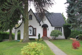
England House
https://search.heritageburnaby.ca/link/landmark501
- Repository
- Burnaby Heritage Planning
- Description
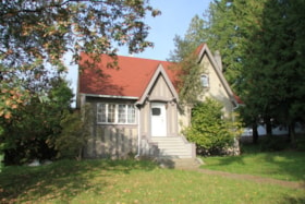
- The Mary England Residence is a one and one-half storey, wood-frame, Period Revival cottage with a steeply pitched, cross-gabled roof. Situated on Griffiths Drive within the Edmonds neighbourhood of Burnaby, the Mary England Residence has an original attached garage.
- Associated Dates
- 1930
- Formal Recognition
- Community Heritage Register
- Other Names
- Mary England Residence
- Street View URL
- Google Maps Street View
- Repository
- Burnaby Heritage Planning
- Other Names
- Mary England Residence
- Geographic Access
- Griffiths Drive
- Associated Dates
- 1930
- Formal Recognition
- Community Heritage Register
- Enactment Type
- Council Resolution
- Enactment Date
- 26/05/2003
- Description
- The Mary England Residence is a one and one-half storey, wood-frame, Period Revival cottage with a steeply pitched, cross-gabled roof. Situated on Griffiths Drive within the Edmonds neighbourhood of Burnaby, the Mary England Residence has an original attached garage.
- Heritage Value
- The Mary England Residence, built in 1930, is valued as a representation of the period revival styles that were popular in the era between the two World Wars. At this time, it was considered the height of fashion for a house to reflect historical styles, even when combined in an eclectic manner, that expressed a domestic ideal of cozy traditionalism. The Mary England Residence is an exuberant example of this trend. Half-timbering, multi-paned and leaded casement windows and a steeply pitched, cross-gabled roof impart a storybook cottage charm. Its first owner, Mary England, was employed for several years as stenographer at the old Burnaby Municipal Hall. An original attached garage is evidence of the growing presence of automobiles in domestic life of the 1930s. Additionally, the Mary England Residence is a testament to the continued suburban growth of the Edmonds neighbourhood. During the Edwardian era, the area experienced a housing boom. Its proximity to New Westminster, coupled with its regional transportation links, made it an attractive area for middle-class residences. Despite the economic recession of the 1930s, the Edmonds area continued to develop with modest but handsome housing.
- Defining Elements
- Key elements that define the heritage character of the Mary England Residence: - location, in the Edmonds neighbourhood of East Burnaby - residential form, scale and massing as expressed by its one and one-half storey height with full basement, rectangular plan and steeply pitched cross-gabled roof - Period Revival elements such as rough-cast stucco, half-timbering, minimal eave overhangs, arched entry with glazed wooden front door, and arched-top feature window - mixture of windows including: double-hung, multi-paned wooden sash windows in double assembly; 6-over-1 double-hung wooden sash windows in multiple assembly; multi-paned casement windows; and straight-leaded feature windows - external parged chimney and two internal chimneys - attached front-gabled garage - associated landscape features including mature deciduous trees and fruit trees
- Historic Neighbourhood
- Edmonds (Historic Neighbourhood)
- Planning Study Area
- Stride Avenue Area
- Function
- Primary Historic--Single Dwelling
- Primary Current--Single Dwelling
- Community
- Edmonds
- Cadastral Identifier
- P.I.D.011-115-424
- Boundaries
- The Mary England Residence is comprised of a single residential lot located at 7276 Griffiths Drive, Burnaby.
- Area
- 1404.26
- Contributing Resource
- Building
- Ownership
- Public (local)
- Documentation
- City of Burnaby Planning and Building Department, Heritage Site Files
- Street Address
- 7276 Griffiths Drive
- Street View URL
- Google Maps Street View
Images
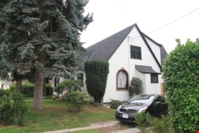
William & Annie Mawhinney Residence
https://search.heritageburnaby.ca/link/landmark653
- Repository
- Burnaby Heritage Planning
- Description
- Residential building.
- Associated Dates
- c.1930
- Street View URL
- Google Maps Street View
- Repository
- Burnaby Heritage Planning
- Geographic Access
- Buckingham Avenue
- Associated Dates
- c.1930
- Description
- Residential building.
- Heritage Value
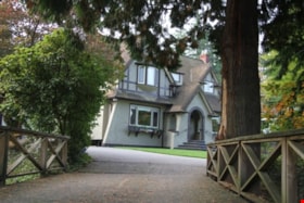
- Local farmers William Alexander Mawhinney (1870-1953) and Annie Josephine Mawhinney (née Sutcliff, 1871-1956) built this residence as their retirement home. It was the last of several houses built in the immediate vicinity by members of the Mawhinney family between 1909 and 1930. Born in Ireland, William Mawhinney first came to Burnaby to help his brother Isaiah establish his fruit farm. Due to his farm management experience, in 1908 William became foreman of the Avalon estate at Deer Lake that was owned by F.J. Hart. When he retired in 1930, William had fifty years of experience as a fruit and grain farmer.This house is situated on its lot at an angle, rather than parallel to the street, to take advantage of the view of wooded Buckingham Creek that runs through the northeast section of the property. Complementing the picturesque character of the property is this charming cottage-style residence, which is an excellent example of an interwar Storybook Cottage. During the years between the two World Wars, domestic styles in North America were resolutely historicist. In order to display good taste, it was expected that a house would have an identifiable period revival style. As economics dictated that houses of the time were generally modest, they often assumed a cottage appearance that provided a romantic ideal of traditional domesticity. The American Sesquicentennial reinforced this historicist trend, and the most popular Hollywood movies of the time were swashbuckling costume dramas. With its distinctive roughcast stucco and half-timbering, this house is an excellent example of this housing trend. The rolled roof edges, with steam-bent cedar shingles, simulate a traditional thatched roof. Other picturesque features include a front porch with round-arched openings, battered wall buttresses, an oriel window and diamond-paned leaded casement windows.
- Locality
- Burnaby Lake
- Historic Neighbourhood
- Burnaby Lake (Historic Neighbourhood)
- Planning Study Area
- Morley-Buckingham Area
- Area
- 1848.00
- Contributing Resource
- Building
- Ownership
- Private
- Street Address
- 6011 Buckingham Avenue
- Street View URL
- Google Maps Street View
Images
Broadview Neighbourhood
https://search.heritageburnaby.ca/link/landmark687
- Repository
- Burnaby Heritage Planning
- Associated Dates
- 1925-1954
- Heritage Value
- Development in the Broadview area slowed during World War Two, but after the war, the area became home to a number of industrial sites. The first major plant to be built here was the Dominion Bridge Company which opened in 1930.
- Historic Neighbourhood
- Broadview (Historic Neighbourhood)
- Planning Study Area
- Cascade-Schou Area
Images
Duncan & Margaret McGregor Estate 'Glen-Lyon' Mansion
https://search.heritageburnaby.ca/link/landmark518
- Repository
- Burnaby Heritage Planning
- Description
- Overlooking the rich farmland of the Fraser River floodplain, 'Glen-Lyon' is an Edwardian era rural estate, with a tall, two and one-half storey plus basement wood-frame mansion, set in a pastoral and formal landscape with an associated barn and early log pond, located near a ravine and forested ar…
- Associated Dates
- 1902
- Formal Recognition
- Heritage Designation, Community Heritage Register
- Street View URL
- Google Maps Street View
- Repository
- Burnaby Heritage Planning
- Geographic Access
- Marine Drive
- Associated Dates
- 1902
- Formal Recognition
- Heritage Designation, Community Heritage Register
- Enactment Type
- Bylaw No. 12183
- Enactment Date
- 11/12/2006
- Description
- Overlooking the rich farmland of the Fraser River floodplain, 'Glen-Lyon' is an Edwardian era rural estate, with a tall, two and one-half storey plus basement wood-frame mansion, set in a pastoral and formal landscape with an associated barn and early log pond, located near a ravine and forested area adjacent to Marine Drive in South Burnaby.
- Heritage Value
- ‘Glen-Lyon’ is valued as an excellent example of a privately-owned Edwardian era country estate built at the turn of the nineteenth century. The property retains significant heritage features including the Edwardian era mansion with rustic Arts and Crafts features, and elements of a working agricultural landscape. The property was originally the Royal City Mills logging camp, and in 1900 was purchased by Duncan Campbell McGregor (1853-1929) and Margaret Jane McGregor (1875-1960), who named their estate ‘Glen-Lyon’ after Duncan McGregor’s birthplace in Perthshire, Scotland. The McGregors were active in municipal affairs and social activities, and played a significant role in the early development of Burnaby. Duncan McGregor served as a city councillor from 1909 to 1912 and was elected reeve of Burnaby in 1913. Margaret McGregor was instrumental in the formation and fundraising activities of the Victoria Order of Nurses in Burnaby. Additionally, the site is historically significant for its association with early social welfare and correctional reform. The estate was sold in 1926 to an inter-denominational religious organization called the Home of the Friendless, which used it as their B.C. headquarters. The organization was charged with several cases of abuse and neglect in 1937, after which a Royal Commission was formed that led to new legislation to regulate and license all private welfare institutions. 'Glen-Lyon' was sold to the provincial government, and was dedicated in 1939 by the Lt.-Gov. E.W. Hamber for use as the New Haven Borstal Home for Boys and Youthful Offenders (later renamed the New Haven Correction Centre). The Borstal movement originated in England in the late nineteenth century, as an alternative to sending young offenders and runaways to prisons by providing reformatories that focused on discipline and vocational skill. This site’s role as the first North American institution devoted to the Borstal School philosophy was historic, and influenced corrections programs across Canada. The site retains significant features from its development in 1939 as the Borstal School, including a large gambrel-roofed barn designed by Chief Provincial Architect Henry Whittaker of the Department of Public Works that is the only remaining structure of its kind in Burnaby. Between 1941 and 1945 the mansion housed the Provincial School for the Deaf and Blind when the Borstal School was closed temporarily as a war measure during the Second World War.
- Defining Elements
- Key elements that define the heritage character of 'Glen-Lyon' Mansion include its: - location on a sloping site with expansive southern exposure, adjacent to Marine Drive - residential form, scale and massing of the house as exemplified by its two and one-half storey height, above-ground basement and rectangular plan - Arts and Crafts elements of the house such as its stone foundation, multi-gabled roof line with steep central hipped roof, symmetrical cross-gables, side shed dormers, bellcast upper walls sheathed in cedar shingles and lower walls sheathed in narrow clapboard - original exterior features of the house such as the full width front verandah with square columns, central staircase on the southern elevation, original doors and stained glass windows; and the irregular fenestration such as double-hung 1-over-1 wooden-sash windows, bay windows, and projecting windows in the gable ends - original interior features of the house such as the U-shaped main stair designed around two symmetrically placed Ionic columns, and interior trim on the main floor including boxed beams and fireplaces - gambrel-roofed barn with roof vent with finial, sliding hay loft and access doors, small multi-pane windows, and lapped wooden siding - associated landscape features such as the original garden plantings with some exotic and many native specimen trees; the original log pond and its concrete Marine Drive causeway and culvert; rockeries and a rose garden
- Historic Neighbourhood
- Fraser Arm (Historic Neighbourhood)
- Planning Study Area
- Big Bend Area
- Architect
- Henry Whittaker
- Function
- Primary Historic--Estate
- Community
- Burnaby
- Cadastral Identifier
- 003-004-661
- Boundaries
- 'Glen-Lyon' is comprised of a single residential lot located at 4250 Marine Drive, Burnaby.
- Area
- 230873.18
- Contributing Resource
- Building
- Ownership
- Private
- Names
- McGregor, Duncan C. (1853-1929)
- Whittaker, Henry
- Home of the Friendless
- Borstal School
- New Haven Correction Centre
- Subjects
- Buildings - Heritage
- Buildings - Residential - Houses
- Buildings - Public - Detention Facilities
- Buildings - Residential
- Street Address
- 4250 Marine Drive
- Street View URL
- Google Maps Street View
Images
East Burnaby Neighbourhood
https://search.heritageburnaby.ca/link/landmark712
- Repository
- Burnaby Heritage Planning
- Associated Dates
- 1925-1954
- Heritage Value
- After a lull in construction during the World War I period, East Burnaby Neighbourhood's growth resumed during the 1920s when many homes and businesses were constructed. The post-World War Two period also saw rapid construction and the creation of new housing developments in response to a population boom. The neighbourhood remained a primarily single-family residential area.
- Historic Neighbourhood
- Edmonds (Historic Neighbourhood)
- Planning Study Area
- Stride Avenue Area
Images
Standard Oil Company / Chevron
https://search.heritageburnaby.ca/link/landmark673
- Repository
- Burnaby Heritage Planning
- Geographic Access
- Willingdon Avenue North
- Associated Dates
- 1935
- Heritage Value
- In 1935 the announcement that the California-based Standard Oil Company was going to build a huge "million dollar" refinery in Burnaby was greeted with cheers by residents who were eager for employment and good news during the Great Depression. The refinery, named Stanovan (aka: Standard Oil - Vancouver) was officially opened in 1936 with the ability to produce 2000 barrels per day. During World War Two, the capacity of the refinery doubled to assist in the war effort. In 1976, the company's name was changed to Chevron Canada Limited.
- Historic Neighbourhood
- Vancouver Heights (Historic Neighbourhood)
- Planning Study Area
- Burnaby Heights Area
- Street Address
- 355 Willingdon Avenue North
Images
Alta Vista Neighbourhood
https://search.heritageburnaby.ca/link/landmark707
- Repository
- Burnaby Heritage Planning
- Associated Dates
- 1925-1954
- Heritage Value
- As with many areas of Burnaby during this period, the years after World War Two marked a rapid growth in residential development in the Alta-Vista Neighbourhood. Subdivisions like Sussex and Suncrest were built and new schools and amenities were constructed to meet the demands of increased population.
- Historic Neighbourhood
- Alta Vista (Historic Neighbourhood)
- Planning Study Area
- Sussex-Nelson Area
Images
Burnaby Lake Neighbourhood
https://search.heritageburnaby.ca/link/landmark700
- Repository
- Burnaby Heritage Planning
- Associated Dates
- 1925-1954
- Heritage Value
- After World War I and the Great Depression of the 1930s, more homes were constructed and subdivisions created in the Burnaby Lake district. The area around Deer Lake gained a reputation for being an "artistic development of commodious homes with park-like grounds."
- Historic Neighbourhood
- Burnaby Lake (Historic Neighbourhood)
- Planning Study Area
- Burnaby Lake Area
Images
Capitol Hill Neighbourhood
https://search.heritageburnaby.ca/link/landmark667
- Repository
- Burnaby Heritage Planning
- Associated Dates
- 1925-1954
- Heritage Value
- Although the Hastings street-car extension to Ellesmere opened in 1913 and there had been much speculation in the area during the real estate boom of 1909-1913, development in Capitol Hill did not really take off until after World War One when workers in Vancouver started to look to Burnaby for affordable but centrally-located neighbourhoods in which to build their homes. The 1913 one-room school had to be replaced in 1923 and in 1948, members of the community came together to build a new Community Hall.
- Historic Neighbourhood
- Capitol Hill (Historic Neighbourhood)
- Planning Study Area
- Capitol Hill Area
Images
Central Park Neighbourhood
https://search.heritageburnaby.ca/link/landmark688
- Repository
- Burnaby Heritage Planning
- Associated Dates
- 1925-1954
- Heritage Value
- Although still largely a rural area during the 1920s, subdivisions began appearing in the Central Park neighbourhood at this time. Development was slowed by the Great Depression of the 1930s but the influx of commercial buildings and new housing initiatives in the post-war boom led to a period of rapid growth especially in the Garden Village subdivision which was undertaken in 1953 with the plan to build 500 modern homes in the 140-acre site. Despite the closure of the interurban line in 1953, the neighbourhood remained an active commercial and residential centre.
- Historic Neighbourhood
- Central Park (Historic Neighbourhood)
- Planning Study Area
- Maywood Area
Images
Ford Motor Company
https://search.heritageburnaby.ca/link/landmark698
- Repository
- Burnaby Heritage Planning
- Geographic Access
- Kingsway
- Associated Dates
- 1938
- Heritage Value
- In 1938, the Ford Motor Company selected Burnaby as its site for a new assembly plant to serve Western Canada. Ford purchased the land which had been owned by the Silver family at Kingsway and Silver Avenue and built its factory using steel from Burnaby's Dominion Bridge Company. During World War II, the plant was used to produce military vehicles. In 1988, the building was demolished and the Station Square development was constructed on the site.
- Historic Neighbourhood
- Central Park (Historic Neighbourhood)
- Planning Study Area
- Maywood Area
- Street Address
- 4600 Kingsway
Images
Joseph Clarke House
https://search.heritageburnaby.ca/link/landmark505
- Repository
- Burnaby Heritage Planning
- Description
- The Joseph Clarke House is a two and one-half storey, wood-frame house, with shingle siding, a front-gabled roof and a full open front verandah. It is located on Jersey Avenue within the Central Park neighbourhood of Burnaby.
- Associated Dates
- 1909
- Formal Recognition
- Heritage Designation, Community Heritage Register
- Other Names
- Joseph & Ellen Clarke House, Clarke Residence
- Street View URL
- Google Maps Street View
- Repository
- Burnaby Heritage Planning
- Other Names
- Joseph & Ellen Clarke House, Clarke Residence
- Geographic Access
- Jersey Avenue
- Sandell Street
- Associated Dates
- 1909
- Formal Recognition
- Heritage Designation, Community Heritage Register
- Enactment Type
- By-law No. 11930
- Enactment Date
- 29/08/2005
- Description
- The Joseph Clarke House is a two and one-half storey, wood-frame house, with shingle siding, a front-gabled roof and a full open front verandah. It is located on Jersey Avenue within the Central Park neighbourhood of Burnaby.
- Heritage Value
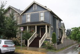
- Built circa 1909 for Central Park farmer Joseph Clarke (1851-1936) and his wife, Ellen (1864-1938), this Edwardian-era farm house is valued for its vernacular design, which demonstrates the utilitarian nature of working-class housing during the boom years prior to the First World War. The Joseph Clarke House is additionally valued for its link with the development of the Central Park neighbourhood during the Edwardian era. The advent of the Central Park interurban rail line in 1892, operated by the B.C. Electric Company, connected the area to Vancouver and led to its suburban development. This is one of the oldest surviving houses in the Central Park neighbourhood. It was designated as a municipal heritage site in 2005 and rehabilitated as part of the adjacent multi-family townhouse and apartment redevelopment.
- Defining Elements
- Key elements that define the heritage character of the Joseph Clarke House include its: - location on Jersey Avenue in the Central Park neighbourhood - residential form, scale and massing as expressed by its two and one-half storey height with rectangular plan, front bay window and front-gabled roof - wood-frame construction - Edwardian era detailing such as the open front verandah, asymmetrical front entrance, glazed front door with sidelights and triangular eave brackets
- Historic Neighbourhood
- Central Park (Historic Neighbourhood)
- Planning Study Area
- Garden Village Area
- Function
- Primary Historic--Single Dwelling
- Primary Current--Single Dwelling
- Community
- Burnaby
- Cadastral Identifier
- P.I.D. 027-101-428
- Boundaries
- The Joseph Clarke House is comprised of a single residential lot located at 5575 Jersey Avenue, Burnaby.
- Area
- 2370
- Contributing Resource
- Building
- Ownership
- Private
- Documentation
- City of Burnaby Planning and Building Department, Heritage Site Files
- Names
- Clarke, Joseph
- Clarke, Ellen
- Street Address
- 5575 Jersey Avenue
- Street View URL
- Google Maps Street View
Images
Lochdale Neighbourhood
https://search.heritageburnaby.ca/link/landmark743
- Repository
- Burnaby Heritage Planning
- Associated Dates
- 1905-1924
- Heritage Value
- "Picturesquely situated on the south-westerly slope of the highest hill on the Burrard Peninsula is a district that in many ways resembles the early pioneer settlements…its centre is at the intersection of east Hastings Street and Sperling Avenue. Only a few years ago a dense forest covered this area and the settlers were few and some distance apart. After the war working men began to enter the Lochdale woods in quest of cheap home-sites. Today there are more than 400 residents in the district who combine to make a happy contented industrious community living on the edge of a big city yet enjoying the life offered by the country...The Community Hall is the centre of all social activities. Dances, concerts and other forms of entertainment are all there...Curtis Street runs from Sperling Avenue up to the hill, locally known as Hastings Grove. From the top on a clear day there is a view for miles around." ~ From the Sunday Province, March 8, 1925.
- Historic Neighbourhood
- Lochdale (Historic Neighbourhood)
- Planning Study Area
- Lochdale Area
Images
Lozells Neighbourhood
https://search.heritageburnaby.ca/link/landmark701
- Repository
- Burnaby Heritage Planning
- Associated Dates
- 1925-1954
- Heritage Value
- Like a lot of residential neighbourhoods in Burnaby during the post-War boom, the Lozells area during the 1925-1954 period was one of new construction and subdivisions. Although more homes were being built, the neighbourhood still retained a somewhat rural characteristic well into the 1950s.
- Historic Neighbourhood
- Lozells (Historic Neighbourhood)
- Planning Study Area
- Government Road Area
Images
North Pacific Lumber Company Ruins
https://search.heritageburnaby.ca/link/landmark627
- Repository
- Burnaby Heritage Planning
- Geographic Access
- Barnet Road
- Associated Dates
- 1909
- Description
- Industrial building.
- Heritage Value
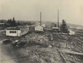
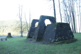
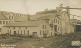
- Located on the shore of Burrard Inlet, these poured concrete piers of the smokestack burner and the former boiler and plant of the North Pacific Lumber Company are among the only remains of the once-thriving industrial site located on the waterfront on the south shore of Burrard Inlet. The sawmill and the Village of Barnet were initiated by David MacLaren, a wealthy lumberman from Buckingham, Quebec, who had previously established the Fraser Mills in Coquitlam in 1889. McLaren gambled that a sawmill on the main line of the C.P.R near Vancouver would serve the Canadian domestic market and be a profitable venture. The North Pacific Lumber Company established itself on this peninsula on Burrard Inlet and was fully operational in 1900. In 1909, the mill was completely burned out by a fire starting in the boiler room. Immediately the plant was rebuilt, modern in every respect and absolutely fireproof, as the entire power plant and boiler room was built of reinforced concrete and steel, of which these ruins are the last remains. The plant closed during the First World War and reopened as the Barnet Lumber Company in 1925 only to close forever in 1931 after a strike during the Great Depression.
- Locality
- Barnet
- Historic Neighbourhood
- Barnet (Historic Neighbourhood)
- Planning Study Area
- Burnaby Mountain Area
Images
Richard & Alice Dunn Residence
https://search.heritageburnaby.ca/link/landmark552
- Repository
- Burnaby Heritage Planning
- Description
- Residential building.
- Associated Dates
- 1939
- Street View URL
- Google Maps Street View
- Repository
- Burnaby Heritage Planning
- Geographic Access
- Jubilee Avenue
- Associated Dates
- 1939
- Description
- Residential building.
- Heritage Value
- This house was built for Richard Dunn, a police sergeant with the B.C. Police force and his wife Alice. This house is a notable example of a Storybook Cottage, dating from just prior to the outbreak of the Second World War. Modest houses of the era often assumed a cottage appearance that provided a romantic ideal of traditional domesticity. With its smooth, planar stucco, severely-clipped roof edges, round-arched door and windows, side arch with a catslide roof, cross-leaded glass and brick detailing, this house is an excellent example of this picturesque housing trend. Located on a corner lot, the house was sited at an angle. The large Chilean Pine, or monkey-puzzle tree, entrance is a remarkable specimen.
- Locality
- Alta Vista
- Historic Neighbourhood
- Alta Vista (Historic Neighbourhood)
- Planning Study Area
- Sussex-Nelson Area
- Ownership
- Private
- Street Address
- 7207 Jubilee Avenue
- Street View URL
- Google Maps Street View
Images
St. John the Divine Anglican Church
https://search.heritageburnaby.ca/link/landmark514
- Repository
- Burnaby Heritage Planning
- Description
- St. John the Divine Anglican Church is a landmark wood-frame Gothic Revival church, with Gothic windows and spire. It is located on Kingsway, one of Burnaby’s main commercial thoroughfares, near the SkyTrain transit line and across the street from Central Park.
- Associated Dates
- 1905
- Formal Recognition
- Community Heritage Register
- Street View URL
- Google Maps Street View
- Repository
- Burnaby Heritage Planning
- Geographic Access
- Kingsway
- Associated Dates
- 1905
- Formal Recognition
- Community Heritage Register
- Enactment Type
- Council Resolution
- Enactment Date
- 09/06/2003
- Description
- St. John the Divine Anglican Church is a landmark wood-frame Gothic Revival church, with Gothic windows and spire. It is located on Kingsway, one of Burnaby’s main commercial thoroughfares, near the SkyTrain transit line and across the street from Central Park.
- Heritage Value
- St. John the Divine Anglican Church is valued as a symbol of the traditions of early Burnaby pioneers and as the oldest surviving church building in the city. Established in 1899, St. John was the first church in the community and was located at a prominent intersection of the old Vancouver-Westminster Road (now Kingsway) and the British Columbia Electric Railway’s interurban station at Central Park. This prominent intersection of the road and rail developed as the town centre of the Central Park district. The first St. John church was destroyed by fire, and was rebuilt at the same location in 1904-05. This church is additionally significant for its association with prominent local architect Joseph Henry Bowman (1864-1943) who emigrated from England in 1888. Bowman was a member of the parish, and designed both the first church and its subsequent replacement. Bowman’s prolific career embraced many stylistic changes and technological advances, and this church is a surviving example of one of his rare religious commissions. The design of the new church's nave and vestry was based on the Gothic Revival style of Christ Church Anglican in Surrey, B.C., which had been the former church of St. John’s incumbent Rev. William Bell. Evolving over time as the congregation grew, the church received a number of early additions, and in 1953 was substantially renovated and enlarged through a new design by Vancouver architect Ross Lort. The original church nave was separated from the tower and turned to allow for a large addition. The congregation relocated to a new church in 1998, and at that time removed the church's memorial windows, leaving behind a number of the original art glass windows installed in the 1920s. The church building was renovated in 2004-05, and surviving original elements were retained and restored, including of the original church tower and interior chancel ceiling. A valued feature of the building is the original cast iron church bell that remains in the tower. It was purchased by the children of the congregation in 1912, and in 1924 was rededicated on Armistice Day as a memorial to Burnaby resident Lt. James Donald McRae Reid, who died in the First World War.
- Defining Elements
- Key elements that define the heritage character of St. John the Divine Anglican Church include its: - location on the north side of Kingsway, opposite Central Park - ecclesiastical form, scale and massing as expressed by the offset tower and tall, gabled roof - tower with its original horizontal wooden drop siding, bellcast square roof with octagonal drum above and bellcast octagonal spire - cedar shingle roof cladding - metal cross at peak of spire - Gothic Revival details such as: Gothic lancet windows with leaded stained glass panels; Gothic entrance door at the base of the tower; pointed-arch louvers in the tower; and exterior gable end scissor-trusses - interior features such as wooden scissor-trusses with diagonal fir tongue and groove panelling on the ceiling above, fir tongue-and-groove panelling on the wall of the nave, and original cedar and fir pews and altar rails - cast iron bell in tower
- Historic Neighbourhood
- Central Park (Historic Neighbourhood)
- Planning Study Area
- Garden Village Area
- Architect
- Joesph Henry Bowman
- Function
- Primary Historic--Place of Worship
- Primary Current--Place of Worship
- Community
- Burnaby
- Cadastral Identifier
- 003-398-871
- Boundaries
- St. John the Divine Anglican Church is comprised of a single institutional lot located at 3891 Kingway, Burnaby.
- Area
- 3486.66
- Contributing Resource
- Building
- Ownership
- Private
- Street Address
- 3891 Kingsway
- Street View URL
- Google Maps Street View
Images
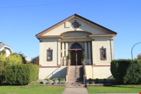
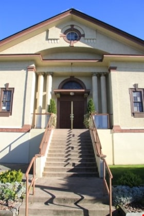
Vancouver Heights Presbyterian Church
https://search.heritageburnaby.ca/link/landmark649
- Repository
- Burnaby Heritage Planning
- Description
- Church building.
- Associated Dates
- 1930
- Street View URL
- Google Maps Street View
- Repository
- Burnaby Heritage Planning
- Geographic Access
- Esmond Avenue
- Associated Dates
- 1930
- Description
- Church building.
- Heritage Value
- This church replaced the first Vancouver Heights Presbyterian Church, which opened in 1911 and later became the Masonic Hall. This site was purchased in 1928, but the new church was not completed until 1930, due to the financial constraints of the Depression era. B.C. Lieutenant-Governor Bruce dedicated the church on Feb. 16, 1931. The building has retained its Classical Revival form and detailing, including its symmetrical design, columns flanking the recessed main entrance and arched windows with keystone detailing. The Vancouver Heights Presbyterian Church was designed by Australian-born architect H.H. Simmonds (1883-1954). After serving in the First World War, Simmonds resumed his local practice, and even during the Depression, his output remained prolific. In the 1920s and 30s, Simmonds was commissioned by the City of Vancouver to replace several pavilions at the Pacific National Exhibition with a consistent grouping of Art Deco buildings including the surviving Livestock Building (1929), Women and Fine Arts Building (1931) and Forum (1933).
- Locality
- Vancouver Heights
- Historic Neighbourhood
- Vancouver Heights (Historic Neighbourhood)
- Planning Study Area
- Burnaby Heights Area
- Architect
- H.H. Simmonds
- Area
- 566.79
- Contributing Resource
- Building
- Ownership
- Private
- Street Address
- 140 Esmond Avenue
- Street View URL
- Google Maps Street View
Images
Westridge Neighbourhood
https://search.heritageburnaby.ca/link/landmark680
- Repository
- Burnaby Heritage Planning
- Associated Dates
- 1925-1954
- Heritage Value
- The Westridge Neighbourhood of Burnaby was created as a new subdivision during the post-World War Two housing boom in Burnaby. Developed by the C.B. Riley Company, it was laid out in a plan contoured to the shapes of the land and was situated to allow residents easy access to main transportation routes.
- Historic Neighbourhood
- Lochdale (Historic Neighbourhood)
- Planning Study Area
- Westridge Area
Images
Willingdon Heights Neighbourhood
https://search.heritageburnaby.ca/link/landmark670
- Repository
- Burnaby Heritage Planning
- Associated Dates
- 1925-1954
- Heritage Value
- Willingdon Heights was another new subdivision developed in Burnaby during the post-World War Two building boom. A brochure about the development published in 1948 proclaimed "the Willingdon Heights 500 home development project in Burnaby fulfills its promise to provide a self-contained community for former members of the armed services and their families...the largest single veteran housing project in Canada as far as homes for individual ownership is concerned, Willingdon Heights development was planned by the Central Mortgage and Housing Corporation...At this date the earlier built rows of homes have passable roads and the owners are improving lawns and gardens in spare time...eventually additional stores and professional services will be installed and recreational projects will add to the amenities of a community of congenial residents..."
- Planning Study Area
- Willingdon Heights Area
