Narrow Results By
Subject
- Buildings - Civic - Museums 2
- Buildings - Commercial - Stores 1
- Buildings - Recreational - Bowling Alleys 1
- Buildings - Schools 1
- Celebrations 1
- Documentary Artifacts - Portraits 1
- Events 1
- First Nations reserves - British Columbia 3
- Geographic Features - Lakes and Ponds 1
- Holidays 3
- Holidays - Canada Day 1
- Holidays - Christmas 2
![Survey and Subdivision plans in New Westminster District, Group 2 - Surrey, ʷməθkʷəy̓əm (Musqueam) Indian Reserve, [190-] thumbnail](/media/hpo/_Data/_BVM_Cartographic_Material/1977/1977_0093_0099_003.jpg?width=280)
Survey and Subdivision plans in New Westminster District, Group 2 - Surrey, ʷməθkʷəy̓əm (Musqueam) Indian Reserve
https://search.heritageburnaby.ca/link/museumdescription7068
- Repository
- Burnaby Village Museum
- Date
- [190-]
- Collection/Fonds
- Burnaby Village Museum Map collection
- Description Level
- File
- Physical Description
- 11 plans : graphite and ink on paper and linen + blueprint ; various sizes mounted on 2 sides of cardboard 76 x 102 cm
- Scope and Content
- File consists of a large board with eleven plans in New Westminster District (Group 2) mounted on one side and five plans in New Westminster District (Group 2) mounted on the other side. Side A: 1. Plan : black ink on linen ; 19.5 x 32 cm. Title reads: "Yale Road / Sec.9 & 10 / B5N R2W" (in blue …
- Repository
- Burnaby Village Museum
- Collection/Fonds
- Burnaby Village Museum Map collection
- Description Level
- File
- Physical Description
- 11 plans : graphite and ink on paper and linen + blueprint ; various sizes mounted on 2 sides of cardboard 76 x 102 cm
- Material Details
- Scales vary (One chain equals 792 inches)
- Indexed number on tape on edge of board reads "99"
- Scope and Content
- File consists of a large board with eleven plans in New Westminster District (Group 2) mounted on one side and five plans in New Westminster District (Group 2) mounted on the other side. Side A: 1. Plan : black ink on linen ; 19.5 x 32 cm. Title reads: "Yale Road / Sec.9 & 10 / B5N R2W" (in blue crayon). Scale: 400 chains = 1 inch. Initals in blue crayon: "RB". Survey plan of Yale Road running through Sections 9 and 10 in New Westminster District, Group 2. (Geographic location: Surrey) 2. Plan : blueprint on paper ; 35.5 x 77.5 cm. Title reads: "Victoria Terminal Railway & Ferry Co. / Plan showing / Proposed Change of Wagon Road through White Rock, B.C" Scale: 400 feet = 1 inch. "H.C. Brice / Engineer in charge / New Westminster, B.C.". February 1906. Signed by "Walter Wilkie B.C.L.S.". Annotation in blue crayon reads: "Sub. of Parts of Sec. 10 & 11 / Tp. 1". Semiahmoo Indian Reserve, Washington Ave., Feb. 1906; 2. Yale Road, Sec.9, 10, B5N R2W, River Rd.; (Geographic location: White Rock) 3. Plan : graphite on paper ; 34 x 94 cm. Title reads: "Tp 7 / NW District" (in graphite) and "Campbell River / in Twp. 7" (in blue crayon). TP7, New Westminster District, Campbell R. in TP4, Coast Meridian, Bamford; (Geographic location: Surrey) Side B: 1. Plan : black ink and col. ink on paper ; 28 x 38.5 cm. Title reads: "G.N.R. / South approach to Wests bridge" (in blue crayon). Scale: 2 chains = 1 inch. Signed by Albert J. Hill, B.C.L.S. Plan covers land in Lot 2, Group 2 and ʷməθkʷəy̓əm (Musqueam) Indian Reserve with approach to bridge running through. (Geographic location: Surrey) 2. Plan : black ink and col. ink on paper ; 26.5 x 44.5 cm. Title reads: "Plan / of / River Frontage / across / Lot 1 BI.N.R.2W. and Lot 6, B.I.N.R.I.W. / N.W.D." Scale: 6 chains = 1 inch. Stamp in red ink reads: "Albert J. Hill, M.A., / Civil Engineer / and / Provincial Land Surveyor, / New Westminster, / B.C." (Geographic location: Surrey) 3. Plan : graphite and ink on paper ; 27 x 44.5 cm. (no formal title) Plan covers area between Yale Road, (north), Quible Road (west) and Townline Road (south). Scale: 4 chains = 1 inch. Signed by Albert J. Hill, B.C.L.S. Annotations in blue crayon read: "also Board 83 / Cancelled" (Geographic location: Surrey) 4. Plan : graphite on paper ; 35.5 x 21.5 cm. Title reads: "Sec 33 B.5N. R2W / see finished drawing Board 125". Initials in blue crayon "RB". Plan certifified by B.C. Provincial Land Surveyor in blue ink "Albert J. Hill". 5. Plan : black ink and col. ink on linen ; 15.5 x 22 cm. Title reads: " Lot 167 Gr. 2" (blue crayon). Scale: 200 feet = 1 inch. Signed by Albert J. Hill, Provincial Land Surveyor. Survey of aarea north of Cloverdale & Guichon Railway with area identified as "Gravel Pit". "Cancelled" in upper left corner of plan. (Geographic location: Surrey) 6. Plan : graphite on paper ; 27 x 27.5 cm. Title reads: "South Half / of / S.W.1/4 Sec.31 TP7 / N.W.D.". Scale: 5 chains = 1 inch. Other title at top of plan reads; "Edward Parr [sic] / Cloverdale". Covers area east of Coast Meridian Road in Section 36. (Geographic location: Surrey) 7. Plan : graphite on paper ; 20.5 x 16 cm. Title reads: "Survey of [sic] Sec. 16, Tp 1[sic] / ..." Other title in blue crayon reads: "N.E. 1/4 Sec. 16 / Twp. 1". (Geographic location: Surrey) 8. Plan : graphite on paper. ; 26.5 x 35 cm. (title is illegible) Plan covers are in New Westminster District, Group 2 along the south shore of the Fraser River. (Geographic location: Surrey)
- Creator
- Hill, Albert James
- Accession Code
- HV977.93.99
- Access Restriction
- No restrictions
- Reproduction Restriction
- No known restrictions
- Date
- [190-]
- Media Type
- Cartographic Material
- Scan Resolution
- 600
- Scan Date
- 2023-06-26
- Notes
- Title based on contents of file
Zoomable Images
![Survey and Subdivision plans in New Westminster District, Group 2 - Surrey, ʷməθkʷəy̓əm (Musqueam) Indian Reserve, [190-] thumbnail](/media/hpo/_Data/_BVM_Cartographic_Material/1977/1977_0093_0099_003_seadragon/1977_0093_0099_003.jpg?w=280)
Survey and Subdivision plans in New Westminster District, Group 2 - Surrey, ʷməθkʷəy̓əm (Musqueam) Indian Reserve, [190-]
Zoom into Image
Hannah (Girlie) Victoria Barnes (nee Love)
https://search.heritageburnaby.ca/link/museumdescription9866
- Repository
- Burnaby Village Museum
- Date
- 1902 (date of original)-[1998]
- Collection/Fonds
- Burnaby Village Museum fonds
- Description Level
- File
- Physical Description
- 1 folder of textual records
- Scope and Content
- File consists of biographical information and copies vital stastic records about Hannah (Girlie) Victoria Barnes (nee Love). Hannah (Girlie) was the youngest daughter of Jesse and Martha Love and grew up in the Love family farmhouse on Cumberland Street. Hannah married Leslie Beecher Barnes at St. …
- Repository
- Burnaby Village Museum
- Collection/Fonds
- Burnaby Village Museum fonds
- Series
- Jesse Love farmhouse series
- Subseries
- Love farmhouse research files subseries
- Description Level
- File
- Physical Description
- 1 folder of textual records
- Scope and Content
- File consists of biographical information and copies vital stastic records about Hannah (Girlie) Victoria Barnes (nee Love). Hannah (Girlie) was the youngest daughter of Jesse and Martha Love and grew up in the Love family farmhouse on Cumberland Street. Hannah married Leslie Beecher Barnes at St. Alban's church in Burnaby on May 14, 1931.
- Accession Code
- BV018.41.77
- Access Restriction
- Subject to FIPPA
- Reproduction Restriction
- Reproductions subject to FIPPA
- Date
- 1902 (date of original)-[1998]
- Media Type
- Textual Record
- Notes
- Title based on content of file
![Survey and Subdivision plans in New Westminster District Group 2 - Surrey, ʷməθkʷəy̓əm (Musqueam) Indian Reserve, [190-] thumbnail](/media/hpo/_Data/_BVM_Cartographic_Material/1977/1977_0093_0086_001.jpg?width=280)
Survey and Subdivision plans in New Westminster District Group 2 - Surrey, ʷməθkʷəy̓əm (Musqueam) Indian Reserve
https://search.heritageburnaby.ca/link/museumdescription7055
- Repository
- Burnaby Village Museum
- Date
- [190-]
- Collection/Fonds
- Burnaby Village Museum Map collection
- Description Level
- File
- Physical Description
- 12 plans : graphite and ink on paper and linen; various sizes mounted on 2 sides of cardboard 76 x 102 cm
- Scope and Content
- File consists of a large board with twelve plans (six plans mounted on each side). All plans are located in New Westminster District, Group 2, covering geographic areas within Surrey. Side A: 1. Plan : black ink on paper ; 20.5 x 57.5 cm. Title reads: "Extension of Tram Line / Hospital to Distill…
- Repository
- Burnaby Village Museum
- Collection/Fonds
- Burnaby Village Museum Map collection
- Description Level
- File
- Physical Description
- 12 plans : graphite and ink on paper and linen; various sizes mounted on 2 sides of cardboard 76 x 102 cm
- Scope and Content
- File consists of a large board with twelve plans (six plans mounted on each side). All plans are located in New Westminster District, Group 2, covering geographic areas within Surrey. Side A: 1. Plan : black ink on paper ; 20.5 x 57.5 cm. Title reads: "Extension of Tram Line / Hospital to Distillery St." Scales: Hor: 100 feet = 1 inch; Vert: 20 feet = 1 inch. tram line, hospital to distillery street; 2. Plan : black ink on linen ; 55 x 46.5 cm. (no title). Plan covers New Westminster District, Group 2, Lots 1,2, 3,4, A and B and the ʷməθkʷəy̓əm (Musqueam) Indian Reserve (1868).along the south shore of the Fraser River opposite City of New Westminster. Portion of land is highlighted in blue along the west border of the "ʷməθkʷəy̓əm (Musqueam) Indian Reserve" and between Lot 2 and Lot 1 and survey lines identified as "Mohun's Line" and Hill's Line. Stamp in red ink on plan reads: "Albert J. HIll, M.A. / Civil Engineer / and Provincial Land Surveyor / New Westminster / B.C." (Geographic location: Surrey also formerly known as Brownsville) 3. Plan : black ink on paper ; 34.5 x 23 cm. Title reads: "Lot 51, Gr.2" (in blue crayon). Plan covers area in New Westminster, Group 2, District Lot 51, north of Mud Bay with the Victoria Terminal Railway and Great Northern Railway lines identified. (Geographic location: Surrey) 4. Plan : graphite on paper ; 16.5 x 18 cm. Title reads: "Sec.20, B5N R2W" (underlined in blue crayon). Sketch plan covers and area in New Westmninster District, Group 2. Plan includes initials "RB" in blue crayon. Scale: 5 chains = 1 inch (Geographic location: Surrey) 5. Plan : graphite on paper with annotations in black ink ; 17 x 21 cm. Title reads: "N.W.1/4 Sec.12 TP2" (in blue crayon). Plan covers an area in New Westminster District Group 2 in Section 12, south of Bose Road. Identifying land marks include names: "Bose", "Smith" and "Church Land" Scale: 8 chains = 1 inch (Geographic location: Surrey) 6. Plan : graphite on paper ; 38 x 26.5 cm. (no title) Sketch plan covers areas in Lot 1 and Lot 2 with land identified as "Dominion Government". (could be survey for ʷməθkʷəy̓əm (Musqueam) Indian Reserve) (Geographic location: Surrey also formerly known as Brownsville) Side B: 1. Plan: black ink on paper ; 53.5 x 38 cm. Title reads:"Plan of Subdivision / of / Section 27, / Block 5 North, Range 2 West / New Westminster District". Scale: 4 chains = 1 inch. Includes area subdivided into 18 lots, south of Hjorth Road (104th Avenue) and west of Quible Road with Yale Road running through. Note in blue crayon reads: See also Bd.93) (Geographic location: Surrey) 2. Plan : black ink on paper ; 35 x 28 cm. Title reads: "Plan / of / Block A - L387A / Surrey". Scale: 2 chains = 1 inch. Annotaion in blue crayon reads: "Blk A / Lot 387a_Gr. 2". Plan covers New Westminster District Group 2, Block A, Lot 387 A, south of Parsons Slough and east of Latimer Road (192nd Street). Stamp in red ink on plan reads: "Albert J. HIll, M.A. / Civil Engineer / and Provincial Land Surveyor / New Westminster / B.C." (Geographic location: Surrey) 3. Plan : black ink on linen ; 50 x 42 cm. Title reads: Plan / of part of / Campbell River / running through / the South portion / of N.E. 1/4, Section 8, / Tp. 7, East of Coast Meridian / also / Showing location / of Shingle Mill and Dam". Scale: 100 feet = 1 inch. Plan covers the area in New Westminster District, Township 7, Section 8 with Hall's Prairie Road (184th Street) running through and intersecting with Campbell River. Vegetation, buildings, bridge, shingle mill are identified. (Geographic location: Surrey) 5. Plan : black ink on linen ; 21.5 x 16.5 cm. Title reads: "Sec.32, B5N R2W". Scale: 10 chains = 1 inch. Signed by "Albert J. Hill / B.C.L.S. / Dec. 23, 1908". Note on survey reads: "No actual survey / 40 ac. surveyed". (Geographic location: Surrey) 6. Plan : graphite on paper ; 22 x 15.5 cm. Title reads: "Position 'A5' Subjects / by _McKenzie" [Geographic location: Surrey]
- Creator
- Hill, Albert James
- Names
- ʷməθkʷəy̓əm (Musqueam)
- Accession Code
- HV977.93.86
- Access Restriction
- No restrictions
- Reproduction Restriction
- No known restrictions
- Date
- [190-]
- Media Type
- Cartographic Material
- Scan Resolution
- 600
- Scan Date
- 2023-06-26
- Notes
- Title based on contents of file
- Numeric stamp on edge of board reads: "86"
Zoomable Images
![Survey and Subdivision plans in New Westminster District Group 2 - Surrey, ʷməθkʷəy̓əm (Musqueam) Indian Reserve, [190-] thumbnail](/media/hpo/_Data/_BVM_Cartographic_Material/1977/1977_0093_0086_003_seadragon/1977_0093_0086_003.jpg?w=280)
Survey and Subdivision plans in New Westminster District Group 2 - Surrey, ʷməθkʷəy̓əm (Musqueam) Indian Reserve, [190-]
Zoom into Image
Receipts from organizations
https://search.heritageburnaby.ca/link/museumdescription10579
- Repository
- Burnaby Village Museum
- Date
- 1908-1953
- Collection/Fonds
- Way Sang Yuen Wat Kee & Co. fonds
- Description Level
- File
- Physical Description
- 1 folder of textual records
- Scope and Content
- File consists of seven receipts that were issued for the following organizations; Ching Wing Chun Society Reading Room 1941, 1952; Ching Wing Chun Society 1953; Victoria Kuomintang Communications Department 1922, 1926; Friends of Wounded Veterans 1940 and Victoria Chinese Benevolent Association 190…
- Repository
- Burnaby Village Museum
- Collection/Fonds
- Way Sang Yuen Wat Kee & Co. fonds
- Description Level
- File
- Physical Description
- 1 folder of textual records
- Material Details
- All receipts are written with Chinese characters
- Scope and Content
- File consists of seven receipts that were issued for the following organizations; Ching Wing Chun Society Reading Room 1941, 1952; Ching Wing Chun Society 1953; Victoria Kuomintang Communications Department 1922, 1926; Friends of Wounded Veterans 1940 and Victoria Chinese Benevolent Association 1908. The Victoria Kuomintang Communications Department receipts were issued to Ko Wun Shan, one of the four key KMT political leaders in Victoria at the time.
- Accession Code
- BV985.5331.10
- Reproduction Restriction
- May be restricted by third party rights
- Date
- 1908-1953
- Media Type
- Textual Record
- Notes
- Title based on contents of file
![Survey and Subdivision plans in New Westminster District Group 1 and Group 2 – Vancouver, ʷməθkʷəy̓əm (Musqueam) Indian Reserve, Burnaby, Surrey
, [1910-1911] thumbnail](/media/hpo/_Data/_BVM_Cartographic_Material/1977/1977_0093_0017_001.jpg?width=280)
Survey and Subdivision plans in New Westminster District Group 1 and Group 2 – Vancouver, ʷməθkʷəy̓əm (Musqueam) Indian Reserve, Burnaby, Surrey
https://search.heritageburnaby.ca/link/museumdescription6986
- Repository
- Burnaby Village Museum
- Date
- [1910-1911]
- Collection/Fonds
- Burnaby Village Museum Map collection
- Description Level
- File
- Physical Description
- 9 plans : 4 plans : blueprint ink on paper + 4 plans : black ink on paper + 1 plan : graphite on paper mounted on 2 sides of cardboard 76 x 102 cm
- Scope and Content
- File consists of a large board of three survey plans in New Westminster District Group 1 mounted on one side and six survey and subdivision plans of District Lot 85, New Westminster District Group 1 mounted on the other side. Side A: 1. Plan : blueprint on paper ; 30.5 x 80 cm. Title reads: "Fras…
- Repository
- Burnaby Village Museum
- Collection/Fonds
- Burnaby Village Museum Map collection
- Description Level
- File
- Physical Description
- 9 plans : 4 plans : blueprint ink on paper + 4 plans : black ink on paper + 1 plan : graphite on paper mounted on 2 sides of cardboard 76 x 102 cm
- Material Details
- Scales vary (One chain equals 792 inches)
- Indexed number on tape on edge of board reads "17"
- Scope and Content
- File consists of a large board of three survey plans in New Westminster District Group 1 mounted on one side and six survey and subdivision plans of District Lot 85, New Westminster District Group 1 mounted on the other side. Side A: 1. Plan : blueprint on paper ; 30.5 x 80 cm. Title reads: "Fraser River Bridge / Plan of South Approach". Plan covers area of land north of the Fraser River and Great Northern Railway with approach for a bridge running through the "ʷməθkʷəy̓əm (Musqueam) Indian Reserve" (ʷməθkʷəy̓əm (Musqueam) First Nation) and lots marked as Dominion Government and the east half of Lot 2 identified as "C. F. Brown" "Plan 851". Plan is identified as "Plan 851 / traced / Mar. 17, 1911". (Geographic location in Vancouver) Scale: 100 feet = 1 inch, Signed by Albert J. Hill / P.L.S." 2. Plan : blueprint on paper ; 36.5 x 35 cm (no title). Includes three plans of lots on the east and west sides of North Road. Note on bottom of blueprint reads: "I.E.B. McKay Surveyor General - hereby certify / that this is a correct tracing from the field / notes of the Royal Engineers on file in the / Lands Department / E.B. McKay (signature) / Surveyor General / Victoria B.C. April 11th 1911" . Plan in top left titled "Page 11 / Vol. 1. / R.E. Notes" covers District Lots east of North Road including Lot 5, Lot 7, Lot 41, Lot 9 and Lot 107 in Coquitlam. Plan in top right corner titled "Page 17 / Vol. 1. / R.E. Notes" covers District Lots east of North Road including Lot 104, Lot 54, Lot 105, Lot 55, Lot 106, Lot 9 and Lot 107 in Coquitlam and Port Moody. Plan in lower left corner titled "Page 15 / Vol. 1 / R.E. Notes" covers District Lots west of North Road including Lot 147, Lot 148, Lot 100, Lot 15 in Burnaby. 3. Plan : blue print on paper ; 29.5 x 41.5 cm. (no formal title). Plan of the North 1/2 of Section 18. Plan covers area in the "North 1/2 of Sec.18 B.5 N RGE 1 W" and "Sec. 18 B.5 N. RGE 1 W" bordered by Section 7, Section 13, Section 17 and Section 19. Bon Accord Road runs through Sec. 18. The plan is signed by surveryor "I.H. Neville Smith... C.E.B.C.L.S. / Mar. 26th 1910" and signed by "Ludwig Pillath". (Geographic location: Surrey) Side B: 1. Plan : blueprint on paper ; 43.5 x 49.5 cm. Title reads: "Plan / of Subdivision / of a Portion / of / Lot 85 / Group One / New Westminster District. Plan covers portion of land east of Deer Lake and Pole Line Road (Sperling Avenue) and south of Hastings Road in District Lot 85 in Burnaby with section 4 and a portion of section 2 coloured in red. Plan is signed by "Albert J. Hill, B.C.L.S." Plan is initialed by: "RB" [sic] (in blue pencil crayon) Scale: 4 chains = 1 inch 2. Plaln : black black ink on linen ; 39 x 37 cm. Title reads: "L.C. Hill's Property, / Burnaby". Plan covers a triangular portion of land east of Pole Line Road (Sperling Avenue) and south of Hastings Road in District Lot 85 in Burnaby. Plan is intitaled by "RB" [sic] (in blue pencil crayon). Scale: 3 chains = 1 mile 3. Plan : graphite on paper ; 23 x 17 cm. Title reads: "Portion of Lot 85 / Gr.1". Plan covers portion of land north east of Deer Lake and west of Pole Line Road (now Sperling Avenue) in District Lot 85 in Burnaby. Plan is stamped in red ink: "Albert J. Hill, Civil Engineer". Plan is initialed by: "RB" [sic] (in blue pencil crayon). Scale: 1 chain = 1 inch 4. Plan : black ink on linen ; 16 x 19 cm. Title reads: "Lot 85". Plan covers the intersection of Pole Line Road (Sperling Avenue) and Hastings Road at the north west section of District Lot 79 and District Lot 85 in Burnaby. Plan is stamped: "A.J. Hill, Civil Engineer" with identitifed in blue pencil crayon. 5. Plan : black ink on paper ; 28.5 x 37 cm. (no formal title) Plan covers an area of land, west of Pole Line Road (Sperling Avenue) and south of Deer Lake in District Lot 85 in Burnaby. Plan is initialed by: "RB" [sic] (in blue pencil crayon) 6. Plan : black ink on paper ; 21 x 34 cm (no formal title). Plan covers an area of land, west of Pole Line Road (Sperling Avenue) and south of Deer Lake in District Lot 85 in Burnaby. Plan is initialed by: "RB" [sic] (in blue pencil crayon)
- Accession Code
- HV977.93.17
- Access Restriction
- No restrictions
- Reproduction Restriction
- No known restrictions
- Date
- [1910-1911]
- Media Type
- Cartographic Material
- Historic Neighbourhood
- Burnaby Lake (Historic Neighbourhood)
- Burquitlam (Historic Neighbourhood)
- Planning Study Area
- Morley-Buckingham Area
- Douglas-Gilpin Area
- Scan Resolution
- 600
- Scan Date
- 2023-06-26
- Notes
- Title based on contents of file
- Scale is measured in chains and feet. (One chain equals 792 inches).
- The term "Lot" also refers to a "District Lot”
- Some plans are stamped: "Albert J. Hill, Civil Engineer / and / Provincial Land Surveyor, / New Westminster, / B.C." and intialed: "RB" [sic]
Zoomable Images
![Survey and Subdivision plans in New Westminster District Group 1 and Group 2 – Vancouver, ʷməθkʷəy̓əm (Musqueam) Indian Reserve, Burnaby, Surrey
, [1910-1911] thumbnail](/media/hpo/_Data/_BVM_Cartographic_Material/1977/1977_0093_0017_003_seadragon/1977_0093_0017_003.jpg?w=280)
Survey and Subdivision plans in New Westminster District Group 1 and Group 2 – Vancouver, ʷməθkʷəy̓əm (Musqueam) Indian Reserve, Burnaby, Surrey , [1910-1911]
Zoom into Image
Great Northern Railway - Vancouver, Victoria & Eastern Railway & Navigation Co.
https://search.heritageburnaby.ca/link/archivedescription792
- Repository
- City of Burnaby Archives
- Date
- 1912
- Collection/Fonds
- City Council and Office of the City Clerk fonds
- Description Level
- File
- Physical Description
- Textual record
- Scope and Content
- File contains correspondence, Council minutes, and a notice of sittings of the Board of Railway Commissioners regarding the installation of double tracking by the Vancouver, Victoria & Eastern Railway & Navigation Co., from Sapperton to Still Creek. File also includes correspondence pertaining to …
- Repository
- City of Burnaby Archives
- Date
- 1912
- Collection/Fonds
- City Council and Office of the City Clerk fonds
- Physical Description
- Textual record
- Description Level
- File
- Record No.
- 2542
- Accession Number
- 2001-02
- Scope and Content
- File contains correspondence, Council minutes, and a notice of sittings of the Board of Railway Commissioners regarding the installation of double tracking by the Vancouver, Victoria & Eastern Railway & Navigation Co., from Sapperton to Still Creek. File also includes correspondence pertaining to the Great Northern Railway siding (spur line) at Douglas Road and Pole Line Road (Sperling Avenue).
- Media Type
- Textual Record
North Road - Vancouver, Victoria and Eastern Railway and Navigation Co.
https://search.heritageburnaby.ca/link/archivedescription817
- Repository
- City of Burnaby Archives
- Date
- 1912-1918
- Collection/Fonds
- City Council and Office of the City Clerk fonds
- Description Level
- File
- Physical Description
- 4 folders textual records and graphic material and cartographic material.
- Scope and Content
- File contains correspondence, reports, notices, Council minutes and other documents created as a result of the applications made by the Vancouver, Victoria and Eastern Railway and Navigation Co. to do work on North Road, such as constructing crossings, bridges, and tunnels through the inter-munici…
- Repository
- City of Burnaby Archives
- Date
- 1912-1918
- Collection/Fonds
- City Council and Office of the City Clerk fonds
- Physical Description
- 4 folders textual records and graphic material and cartographic material.
- Description Level
- File
- Record No.
- 2570
- Accession Number
- 2001-02
- Scope and Content
- File contains correspondence, reports, notices, Council minutes and other documents created as a result of the applications made by the Vancouver, Victoria and Eastern Railway and Navigation Co. to do work on North Road, such as constructing crossings, bridges, and tunnels through the inter-municipal highway between Burnaby and Coquitlam.
- Media Type
- Textual Record
- Cartographic Material
- Notes
- 3 blueprint plans of a proposed bridge and tunnel : M9-B-1-14; M9-B-1-15; and M9-B-3-14. 2 black and white photographs [not found as of May 8, 2003]
North Road car line
https://search.heritageburnaby.ca/link/archivedescription929
- Repository
- City of Burnaby Archives
- Date
- 1913-1942
- Collection/Fonds
- City Council and Office of the City Clerk fonds
- Description Level
- File
- Physical Description
- Textual record
- Scope and Content
- File contains correspondence and reports arising from the application by the Vancouver, Victoria & Eastern Railway & Navigation Co. for authority to expropriate lands to divert Gunn and Brunette Roads and to provide an overhead crossing at North Road.
- Repository
- City of Burnaby Archives
- Date
- 1913-1942
- Collection/Fonds
- City Council and Office of the City Clerk fonds
- Physical Description
- Textual record
- Description Level
- File
- Record No.
- 2700
- Accession Number
- 2001-02
- Scope and Content
- File contains correspondence and reports arising from the application by the Vancouver, Victoria & Eastern Railway & Navigation Co. for authority to expropriate lands to divert Gunn and Brunette Roads and to provide an overhead crossing at North Road.
- Media Type
- Textual Record
Intercession service on anniversary of declaration of war
https://search.heritageburnaby.ca/link/archivedescription1008
- Repository
- City of Burnaby Archives
- Date
- 1915-1918
- Collection/Fonds
- City Council and Office of the City Clerk fonds
- Description Level
- File
- Physical Description
- Textual record
- Scope and Content
- File contains correspondence discussing the preparations for provincial patriotic celebrations held in 1915, 1916, and 1917 commemorating the declaration of World War One. File also includes a speech delivered by Lieutenant-Governor Barnard on August 4th, 1915, at the Victoria Patriotic Demonstrat…
- Repository
- City of Burnaby Archives
- Date
- 1915-1918
- Collection/Fonds
- City Council and Office of the City Clerk fonds
- Physical Description
- Textual record
- Description Level
- File
- Record No.
- 2787
- Accession Number
- 2001-02
- Scope and Content
- File contains correspondence discussing the preparations for provincial patriotic celebrations held in 1915, 1916, and 1917 commemorating the declaration of World War One. File also includes a speech delivered by Lieutenant-Governor Barnard on August 4th, 1915, at the Victoria Patriotic Demonstration, and programme books and notice of services. As well, there is also a telegram of November 11, 1918 from the City Reeve to the Governor General of Canada and General Currie in France to offer congratulations to Canadian soldiers on the end of World War One.
- Media Type
- Textual Record
![50th Anniversary G.G.C., [1926-1979] thumbnail](/media/hpo/_Data/_BVM_Images/2015/2015_0035_0166_folded_redacted.jpg?width=280)
50th Anniversary G.G.C.
https://search.heritageburnaby.ca/link/museumdescription4594
- Repository
- Burnaby Village Museum
- Date
- [1926-1979]
- Collection/Fonds
- Burnaby Girl Guides fonds
- Description Level
- File
- Physical Description
- 1 scrapbook (51 photographs + 1 postcard + textual records)
- Scope and Content
- File consists of a scrapbook with a handpainted wood cover titled "50th Anniversary / G.G.C". The scrapbook documents events and ceremonies of the 4th Guide Company with the first half of the scrapbook containing photographs and documents regarding the 50th Anniversary of Girl Guides which was cele…
- Repository
- Burnaby Village Museum
- Collection/Fonds
- Burnaby Girl Guides fonds
- Description Level
- File
- Physical Description
- 1 scrapbook (51 photographs + 1 postcard + textual records)
- Scope and Content
- File consists of a scrapbook with a handpainted wood cover titled "50th Anniversary / G.G.C". The scrapbook documents events and ceremonies of the 4th Guide Company with the first half of the scrapbook containing photographs and documents regarding the 50th Anniversary of Girl Guides which was celebrated at St. Nicholas Church in 1960 while the second half documents earlier events from 1926, as well as other events in the 1960s such as; "Year of the Golden Jubilee", a parade in North Burnaby as well as Thinking Day 1976-1978, banquets, a disco contest, camping on Hollyburn mountain and a visit to Victoria in 1979. On November 3rd, 1926 the company was registered as the 5th Burnaby Guide company, in 1951 the number was changed to the 4th Vancouver Guide Company and in 1956 the number was changed to the 4th Burnaby Company.
- Accession Code
- BV015.35.166
- Access Restriction
- No restrictions
- Reproduction Restriction
- May be restricted by third party rights
- Date
- [1926-1979]
- Media Type
- Textual Record
- Photograph
- Notes
- Transcribed title
- Items within scrapbook have been redacted in compliance with Section 22 of FIPPA
- A selection of photographs are described at item level (BV015.35.285 to BV.015.35.300).
Images
![50th Anniversary G.G.C., [1926-1979] thumbnail](/media/hpo/_Data/_BVM_Images/2015/2015_0035_0166_folded_redacted.jpg)
Documents
Graduation records
https://search.heritageburnaby.ca/link/archivedescription82734
- Repository
- City of Burnaby Archives
- Date
- [1930-1941]
- Collection/Fonds
- Hazel Simnett collection
- Description Level
- File
- Physical Description
- 1 folder of textual records
- Scope and Content
- File consists of two envelopes and one dictionary. One envelope is empty and is addressed to: "To Whom it May Concern" and is from: "Hugh M. Fraser High School / 2350 Kingsway / New Westminster, BC". It most likely contained the reference letter from May 12, 1941 written by the principal of Hugh M.…
- Repository
- City of Burnaby Archives
- Date
- [1930-1941]
- Collection/Fonds
- Hazel Simnett collection
- Physical Description
- 1 folder of textual records
- Description Level
- File
- Record No.
- MSS167-013
- Accession Number
- 2013-22
- Scope and Content
- File consists of two envelopes and one dictionary. One envelope is empty and is addressed to: "To Whom it May Concern" and is from: "Hugh M. Fraser High School / 2350 Kingsway / New Westminster, BC". It most likely contained the reference letter from May 12, 1941 written by the principal of Hugh M. Fraser Senior and Junior High Schools. The second envelope is addressed to "Miss Hazel Simnett / 4019 Kingsway / New Westminster, BC" from the Department of Education in Victoria, BC. It contains the reference letter as discussed previously, a University Entrance Examination certificate, a High School Graduation certificate from Burnaby South High School, a Grade Twelve Examination Junior Matriculation certificate and a purple and gold ribbon. The dictionary is a Nelson's "Highroads" English Dictionary. Inside an inscription reads: "Hazel Simnett / 4019 Kingsway / Burnaby / BSHS / Hazel Simnett / Kingsway West School".
- Subjects
- Personal Symbols - Certificates
- Names
- Simnett, Hazel
- Media Type
- Textual Record
- Notes
- Title based on contents of file
- Simnett personal papers series
- Geographic Access
- Kingsway
- Historic Neighbourhood
- Central Park (Historic Neighbourhood)
- Planning Study Area
- Garden Village Area
Barnet Park papers
https://search.heritageburnaby.ca/link/archivedescription64451
- Repository
- City of Burnaby Archives
- Date
- 1942-1978
- Collection/Fonds
- Burnaby Historical Society fonds
- Description Level
- File
- Physical Description
- 1 file of textual records
- Scope and Content
- File consists of papers pertaining to the development of Barnet Park, including Engineering Department Reports to Council, correspondence between the North Burnaby Board of Trade and the Deputy Minister of Lands in Victoria, Burnaby Citizens' Committee for Access to Burrard Inlet at Barnet Park rec…
- Repository
- City of Burnaby Archives
- Date
- 1942-1978
- Collection/Fonds
- Burnaby Historical Society fonds
- Subseries
- North Burnaby Board of Trade subseries
- Physical Description
- 1 file of textual records
- Description Level
- File
- Record No.
- MSS118-002
- Accession Number
- BHS2005-8
- Scope and Content
- File consists of papers pertaining to the development of Barnet Park, including Engineering Department Reports to Council, correspondence between the North Burnaby Board of Trade and the Deputy Minister of Lands in Victoria, Burnaby Citizens' Committee for Access to Burrard Inlet at Barnet Park recommendations and a map of Burnaby from 1968 (to accompany Burnaby Zoning Bylaw 4742).
- Media Type
- Textual Record
- Notes
- Title based on contents of file
![Girl Guide scrapbook, [1950-1969] (date of original), copied 2016 thumbnail](/media/hpo/_Data/_BVM_Images/2015/2015_0035_0165_folded.jpg?width=280)
Girl Guide scrapbook
https://search.heritageburnaby.ca/link/museumdescription4593
- Repository
- Burnaby Village Museum
- Date
- [1950-1969] (date of original), copied 2016
- Collection/Fonds
- Burnaby Girl Guides fonds
- Description Level
- File
- Physical Description
- 1 scrapbook (2 digital files : col. (pdfs) + 31 photographs : col. (tiffs))
- Scope and Content
- File consists of images of a scrapbook containing newspaper clippings and some original programs. Many pages of the scrapbook identify themes for newspaper articles such as: "Expansion in Douglas District"; "New Guides / - New Flag"; "Fly ups"; "Honours to Guides"; "Progress at Wilson Creek"; "1959…
- Repository
- Burnaby Village Museum
- Collection/Fonds
- Burnaby Girl Guides fonds
- Description Level
- File
- Physical Description
- 1 scrapbook (2 digital files : col. (pdfs) + 31 photographs : col. (tiffs))
- Scope and Content
- File consists of images of a scrapbook containing newspaper clippings and some original programs. Many pages of the scrapbook identify themes for newspaper articles such as: "Expansion in Douglas District"; "New Guides / - New Flag"; "Fly ups"; "Honours to Guides"; "Progress at Wilson Creek"; "1959 / Mrs McKee-Wilson meets Prince Phillip in Victoria"; "Mrs. Roper / becomes / Area Commissioner / 1962"; "Gold Cord to Marilyn Pringle / April 1964"; "Baden Powell Day"; "Fifty Years of C.G.G. / in Burnaby"; "Gold Cord Presentation"; "Guides Lend a Hand" and "An Active District" . Original programs are identified as: "Thinking Day Services / Feb. 1964"; "Thinking Day Service / Edmonds District Guides and Brownies / February 21st 1965"; "Thinking Day Ceremony / Edmonds Junior High School / February 26, 1961" and "Guider's Own Service / Christ Church Memorial Hall / Victoria, B.C. / Saturday April 4th, 1959".
- Names
- Girl Guides of Canada
- Accession Code
- BV015.35.165
- Access Restriction
- No restrictions
- Reproduction Restriction
- May be restricted by third party rights
- Date
- [1950-1969] (date of original), copied 2016
- Media Type
- Textual Record
- Notes
- Title based on contents of file
Images
![Girl Guide scrapbook, [1950-1969] (date of original), copied 2016 thumbnail](/media/hpo/_Data/_BVM_Images/2015/2015_0035_0165_folded.jpg)
Documents
Digney film 1 - Digney family in Burnaby, Okanagan, Vancouver, Victoria, California and Seattle
https://search.heritageburnaby.ca/link/museumdescription10593
- Repository
- Burnaby Village Museum
- Date
- [between 1954 and 1965] (date of original), copied 2019
- Collection/Fonds
- Digney Family fonds
- Description Level
- File
- Physical Description
- 1 video recording (mp4) (23 min., 34 sec.) : digital, 16 fps, col., si.
- Scope and Content
- File consists of a film compliation created by Andy Digney and his son Ernest "Dig" Digney. The film footage is a compilation of twenty eight short segments taken at different times in various locations. The film footage documents family events, gatherings and vacations. The film opens with an outd…
- Repository
- Burnaby Village Museum
- Collection/Fonds
- Digney Family fonds
- Description Level
- File
- Physical Description
- 1 video recording (mp4) (23 min., 34 sec.) : digital, 16 fps, col., si.
- Scope and Content
- File consists of a film compliation created by Andy Digney and his son Ernest "Dig" Digney. The film footage is a compilation of twenty eight short segments taken at different times in various locations. The film footage documents family events, gatherings and vacations. The film opens with an outdoor Christmas display and is followed by several other film segments taking place in Burnaby at 7749 Kaymur Drive; 6521 Bonsor Street and Brentwood Mall as well as Okanagon Lake Resort; California; Seattle; Vancouver and Victoria.
- Subjects
- Holidays - Christmas
- Names
- Digney, Andy
- Geographic Access
- Bonsor Avenue
- Accession Code
- BV019.18.3
- Access Restriction
- No restrictions
- Reproduction Restriction
- May be restricted by third party rights
- Date
- [between 1954 and 1965] (date of original), copied 2019
- Media Type
- Moving Images
- Photographer
- Digney, Ernest Frank "Dig"
- Digney, Andy
- Notes
- Title based on contents of film
- Digitized film is a copy from original 8 mm film
- 12 film segments from this compilation with Burnaby content are described at item level and available for viewing on Heritage Burnaby
- Contact Burnaby Village Museum to view entire content
Digney film 2 - Family in Burnaby, Construction of Simpsons-Sears building and wedding
https://search.heritageburnaby.ca/link/museumdescription10598
- Repository
- Burnaby Village Museum
- Date
- [between 1954 and 1964] (date of original), copied 2019
- Collection/Fonds
- Digney Family fonds
- Description Level
- File
- Physical Description
- 1 video recording (mp4) (26 min., 51 sec.) : digital, 16 fps, col., si.
- Scope and Content
- Film compilation created by Andy Digney and his son Ernest "Dig" Digney. The film opens with scenes of different dogs playing outside; exterior of Andy and Alice Digney’s house on Kaymar Drive; interior of the Digney bowling alley with pins being reset; interior of Andy Digney’s greenhouse at his h…
- Repository
- Burnaby Village Museum
- Collection/Fonds
- Digney Family fonds
- Description Level
- File
- Physical Description
- 1 video recording (mp4) (26 min., 51 sec.) : digital, 16 fps, col., si.
- Scope and Content
- Film compilation created by Andy Digney and his son Ernest "Dig" Digney. The film opens with scenes of different dogs playing outside; exterior of Andy and Alice Digney’s house on Kaymar Drive; interior of the Digney bowling alley with pins being reset; interior of Andy Digney’s greenhouse at his house on Kaymar Drive; construction of the Simpsons-Sears building in 1954 behind the Digney home at 3698 Bonsor Street; unidentified outdoor wedding attended by the Digney's and Swans; Campbell family gathering in Victoria; gathering of friends and family inside Alice and Andy Digney’s home on Kaymar Drive before they leave for their World tour in 1964.
- Creator
- Digney, Andy
- Geographic Access
- Bonsor Avenue
- Kaymar Drive
- Accession Code
- BV019.18.4
- Access Restriction
- No restrictions
- Reproduction Restriction
- No known restrictions
- Date
- [between 1954 and 1964] (date of original), copied 2019
- Media Type
- Moving Images
- Photographer
- Digney, Andy
- Digney, Ernest Frank "Dig"
- Notes
- Title based on contents of film
- Digitized film is a copy from original 8 mm film
- 9 film clips from this compilation are described at item level and available for viewing on Heritage Burnaby
- Contact Burnaby Village Museum to view entire content
Kiwanis Club brochures
https://search.heritageburnaby.ca/link/archivedescription59219
- Repository
- City of Burnaby Archives
- Date
- 1954-1958
- Collection/Fonds
- Burnaby Historical Society fonds
- Description Level
- File
- Physical Description
- 1 file of textual records
- Scope and Content
- File consists of papers pertaining to Pacific Northwest District Kiwanis Club annual conventions as well as to various Kiwanis Club events throughout the Lower Mainland and Victoria.
- Repository
- City of Burnaby Archives
- Date
- 1954-1958
- Collection/Fonds
- Burnaby Historical Society fonds
- Subseries
- North Burnaby Kiwanis Club subseries
- Physical Description
- 1 file of textual records
- Description Level
- File
- Record No.
- MSS092-022
- Access Restriction
- In Archives only
- Accession Number
- BHS2007-04
- Scope and Content
- File consists of papers pertaining to Pacific Northwest District Kiwanis Club annual conventions as well as to various Kiwanis Club events throughout the Lower Mainland and Victoria.
- Media Type
- Textual Record
- Notes
- Title based on contents of file
Digney Film 5 - Okanagan, Mattick's Farm and world tour
https://search.heritageburnaby.ca/link/museumdescription10661
- Repository
- Burnaby Village Museum
- Date
- [196-] (date of original), copied 2019
- Collection/Fonds
- Digney Family fonds
- Description Level
- File
- Physical Description
- 1 video recording (mp4) (54 min., 1 sec.) : digital, 16 fps, col., si.
- Scope and Content
- File consists of a film compliation created by Andy Digney and his son Ernest "Dig" Digney. The film footage is a combination of fifteen short segments taken at different times in various locations. The Film segments document the Digney family at their cottage on Okanagan Lake; a visit to Mattick's…
- Repository
- Burnaby Village Museum
- Collection/Fonds
- Digney Family fonds
- Description Level
- File
- Physical Description
- 1 video recording (mp4) (54 min., 1 sec.) : digital, 16 fps, col., si.
- Scope and Content
- File consists of a film compliation created by Andy Digney and his son Ernest "Dig" Digney. The film footage is a combination of fifteen short segments taken at different times in various locations. The Film segments document the Digney family at their cottage on Okanagan Lake; a visit to Mattick's Farm and minature railway in Victoria, British Columbia and parts of Andy Digney's world tour and ocean voyage on a passenger freighter where he travels to parts of Southeast Asia.
- Creator
- Digney, Andy
- Accession Code
- BV019.18.7
- Access Restriction
- No restrictions
- Reproduction Restriction
- No known restrictions
- Date
- [196-] (date of original), copied 2019
- Media Type
- Moving Images
- Photographer
- Digney, Ernest Frank "Dig"
- Digney, Andy
- Notes
- Title based on contents of film compilation
- Film segment originates from digitized version of original 8 mm film
- Contact Burnaby Village Museum to view content
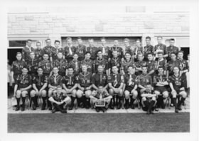
Queen Scout ceremony photographs
https://search.heritageburnaby.ca/link/archivedescription55152
- Repository
- City of Burnaby Archives
- Date
- 1961-1980
- Collection/Fonds
- Burnaby Historical Society fonds
- Description Level
- File
- Physical Description
- 25 photographs : b&w ; 25 cm x 20 cm and smaller
- Scope and Content
- Photographs of the Queen Scout award ceremony and series of Scout troop group portraits.
- Repository
- City of Burnaby Archives
- Date
- 1961-1980
- Collection/Fonds
- Burnaby Historical Society fonds
- Subseries
- Burnaby Scouts subseries
- Physical Description
- 25 photographs : b&w ; 25 cm x 20 cm and smaller
- Description Level
- File
- Record No.
- 631-034
- Access Restriction
- No restrictions
- Reproduction Restriction
- Reproduce for fair dealing purposes only
- Accession Number
- BHS1994-05
- Scope and Content
- Photographs of the Queen Scout award ceremony and series of Scout troop group portraits.
- Names
- Boy Scouts of Canada
- Media Type
- Photograph
- Photographer
- Gibson, Wilfred
- Notes
- Transcribed title
- Title transcribed from envelope in which photographs were originally housed
- Photographer's stamp on verso of all photographs in file: "Gibson's Studio Photographers 819 Broughton St. Victoria, B.C."
- Note in blue ink on recto of 631-034-14 reads: "Reversed as for your [illegible] (new"). Note in blue ink on verso reads: "As you can see - everything is reversed. Whoever said the original prints were printed wrong are wrong themselves. Will Gilin" Note in pencil on verso reads: "Troop #3".
- Note in blue ink on recto of 631-034-15 reads: "New one." Note in blue ink on verso reads: "As per your request this print is reversed. As you can see every-thing is backward. Will Gilin." Note in pencil on verso reads: "Troop #1".
- Note in pencil on verso of 631-034-23 reads: "Scotish Jamoree 75-80?". Notes on verso in pencil and ink identify individuals in photograph: Fred Otte, Gary Otte, Roger Gallaway, Dennis Moore, Jan [illegible], Barkley Ellsworth, Louis MacKinnon, Nigel Tennesan, Ron Murdoch, Fred Smith, Craig Smith, JOhn Steeves, and Wayne Vogan.
Images

Hazel L'Estrange papers
https://search.heritageburnaby.ca/link/archivedescription58366
- Repository
- City of Burnaby Archives
- Date
- 1963 (date of original) -1991
- Collection/Fonds
- Burnaby Historical Society fonds
- Description Level
- File
- Physical Description
- 1 file of textual records
- Scope and Content
- File consists of papers (mostly photocopies) pertaining to the naming of the Bob Prittie Metrotown Library branch; Bob Prittie's name was put forward by Hazel L'Estrange. Also included in the file are pages from "Legion" magazine which include an article on the Victoria Order of Nurses.
- Repository
- City of Burnaby Archives
- Date
- 1963 (date of original) -1991
- Collection/Fonds
- Burnaby Historical Society fonds
- Subseries
- Hazel L'Estrange subseries
- Physical Description
- 1 file of textual records
- Description Level
- File
- Record No.
- MSS074-001
- Accession Number
- BHS1992-27
- Scope and Content
- File consists of papers (mostly photocopies) pertaining to the naming of the Bob Prittie Metrotown Library branch; Bob Prittie's name was put forward by Hazel L'Estrange. Also included in the file are pages from "Legion" magazine which include an article on the Victoria Order of Nurses.
- Media Type
- Textual Record
- Notes
- Title based on contents of file
Directory of BC Arts - Community Arts Council of Greater Victoria
https://search.heritageburnaby.ca/link/archivedescription56516
- Repository
- City of Burnaby Archives
- Date
- 1973
- Collection/Fonds
- Burnaby Historical Society fonds
- Description Level
- File
- Physical Description
- Textual record
- Repository
- City of Burnaby Archives
- Date
- 1973
- Collection/Fonds
- Burnaby Historical Society fonds
- Subseries
- Burnaby Arts Council subseries
- Physical Description
- Textual record
- Description Level
- File
- Record No.
- 39944
- Accession Number
- BHS1998-06
- Media Type
- Textual Record