Narrow Results By
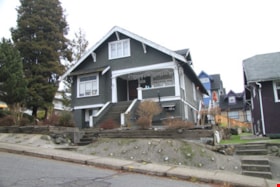
François & Cezarie Comeau Residence
https://search.heritageburnaby.ca/link/landmark580
- Repository
- Burnaby Heritage Planning
- Description
- Residential building.
- Associated Dates
- c.1925
- Street View URL
- Google Maps Street View
- Repository
- Burnaby Heritage Planning
- Geographic Access
- Esmond Avenue
- Associated Dates
- c.1925
- Description
- Residential building.
- Heritage Value
- This home was built for Francois Xavier “Frank” Comeau (1863-1943), a blacksmith who moved from Quebec to Vancouver in about 1890, and his wife Cezarie Marie (née Fortin, 1860-1950), also from Quebec, whom he married in 1903. Featuring a front gabled roof with decorative triangular eave brackets, this comfortable Craftsman bungalow displays other characteristics typical of the style such as lapped siding at the foundation, a shingle-clad main floor, casement windows and stained glass transoms on the front elevation. The most notable feature of the plan is the inset verandah with subtle segmental-arched openings and tapered square columns.
- Locality
- Vancouver Heights
- Historic Neighbourhood
- Vancouver Heights (Historic Neighbourhood)
- Planning Study Area
- Burnaby Heights Area
- Area
- 566.71
- Contributing Resource
- Building
- Ownership
- Private
- Street Address
- 306 Esmond Avenue
- Street View URL
- Google Maps Street View
Images
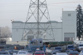
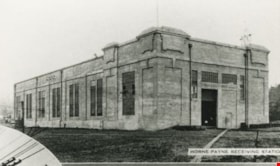
Horne-Payne Receiving Station
https://search.heritageburnaby.ca/link/landmark594
- Repository
- Burnaby Heritage Planning
- Description
- Industrial building.
- Associated Dates
- 1913
- Street View URL
- Google Maps Street View
- Repository
- Burnaby Heritage Planning
- Geographic Access
- 2nd Avenue
- Associated Dates
- 1913
- Description
- Industrial building.
- Heritage Value
- Constructed as an electrical grid substation by the B.C. Electric Railway Company, the Horne-Payne substation was part of the expansion of this utility company to central Burnaby that occurred as a result of the opening of the Burnaby Lake Interurban line in 1911. The Receiving Station is intended to rearrange the company’s system of distributing power over the whole of the Burrard Peninsula. Power will come to the transformers there and be converted and distributed to the various substations in Vancouver, New Westminster and the suburbs...Work has already been started at the foundation for the new plant. (Vancouver Daily Province, April 29, 1913) When constructed the substation was situated within a forest clearing in a largely undeveloped section of northwest Burnaby. The area now surrounding the substation is heavily developed for semi-industrial purposes. This steel-frame and poured concrete structure was designed to be utilitarian, but with decorative detailing. The south-facing front of the structure features massed corners detailed with decorative relief panels at the roofline. Additionally, this well-balanced building displayed symmetrical fenestration with blind, and tall multi-paned steel-sash windows, some crowned with keystones. A tower added to the east side of the building’s front is the most substantial change made to the appearance of the Horne-Payne substation. This industrial structure was designed by prominent British Columbian architect, Robert Lyon (1879-1963). Born in Edinburgh, Lyon apprenticed and worked as an architect in Scotland until 1908 before moving to New York in 1909. In 1911, he began his career in Vancouver as an “architectural engineer,” with the B.C. Electric Company that lasted until 1918. After a short tenure in the lumber industry, Lyon returned to architecture, this time with his own firm in Penticton. Active in municipal politics, he was instrumental in the incorporation of Penticton as a city, and became its first mayor from 1948-1949. Lyon retired from architecture in 1958 and died in 1963. Lyon also designed the Central Park Gate in Burnaby.
- Locality
- Vancouver Heights
- Historic Neighbourhood
- Vancouver Heights (Historic Neighbourhood)
- Planning Study Area
- West Central Valley Area
- Architect
- Robert Lyon
- Area
- 47400.00
- Contributing Resource
- Building
- Ownership
- Private
- Street Address
- 3700 2nd Street
- Street View URL
- Google Maps Street View
Images
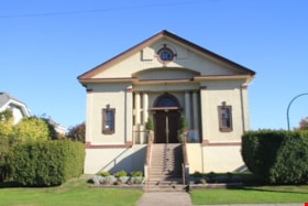
Vancouver Heights Presbyterian Church
https://search.heritageburnaby.ca/link/landmark649
- Repository
- Burnaby Heritage Planning
- Description
- Church building.
- Associated Dates
- 1930
- Street View URL
- Google Maps Street View
- Repository
- Burnaby Heritage Planning
- Geographic Access
- Esmond Avenue
- Associated Dates
- 1930
- Description
- Church building.
- Heritage Value
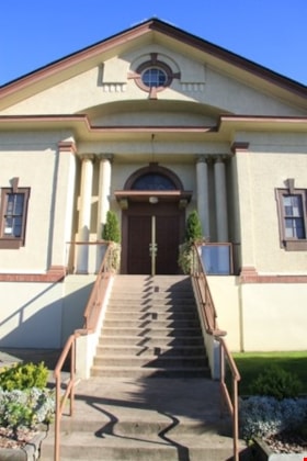
- This church replaced the first Vancouver Heights Presbyterian Church, which opened in 1911 and later became the Masonic Hall. This site was purchased in 1928, but the new church was not completed until 1930, due to the financial constraints of the Depression era. B.C. Lieutenant-Governor Bruce dedicated the church on Feb. 16, 1931. The building has retained its Classical Revival form and detailing, including its symmetrical design, columns flanking the recessed main entrance and arched windows with keystone detailing. The Vancouver Heights Presbyterian Church was designed by Australian-born architect H.H. Simmonds (1883-1954). After serving in the First World War, Simmonds resumed his local practice, and even during the Depression, his output remained prolific. In the 1920s and 30s, Simmonds was commissioned by the City of Vancouver to replace several pavilions at the Pacific National Exhibition with a consistent grouping of Art Deco buildings including the surviving Livestock Building (1929), Women and Fine Arts Building (1931) and Forum (1933).
- Locality
- Vancouver Heights
- Historic Neighbourhood
- Vancouver Heights (Historic Neighbourhood)
- Planning Study Area
- Burnaby Heights Area
- Architect
- H.H. Simmonds
- Area
- 566.79
- Contributing Resource
- Building
- Ownership
- Private
- Street Address
- 140 Esmond Avenue
- Street View URL
- Google Maps Street View
