Narrow Results By
Subject
- Documentary Artifacts - Cards 1
- Documentary Artifacts - Certificates 1
- Documentary Artifacts - Letters and Envelopes 23
- Education 1
- Events - May Day 1
- First Nations reserves - British Columbia 1
- Holidays - Christmas 1
- Migration 1
- Occupations - Land Surveyors 1
- Organizations - Girls' Societies and Clubs 1
- Persons - Chinese Canadians 2
- Public Services - Correctional 1
Creator
- Adams, Edith 5
- Archives of Vancouver Society 1
- Atkinson, R. 1
- British Columbia Underwriters' Association 13
- Canadian Railroad Historical Association. Pacific Coast Division 1
- Coast Map and Blue Print Co. 1
- Dominion Map and Blueprint Co. 1
- Draper, William Nelson 1
- Government of Canada 1
- Gwyer, W. K. 1
- Hill, Albert James 1
- Hill and Barnett Land Surveyors 1
The City of Vancouver B.C.
https://search.heritageburnaby.ca/link/archivedescription66103
- Repository
- City of Burnaby Archives
- Date
- [between 1916 and 1929]
- Collection/Fonds
- Burnaby Historical Society fonds
- Description Level
- Item
- Physical Description
- 1 map : b&w ink on paper ; 56 x 107 cm folded to 21 x 12.5 cm
- Scope and Content
- Item is a map of "[the] City of Vancouver B.C" drawn prior to amalgamation of Point Grey and South Vancouver with the City of Vancouver.
- Repository
- City of Burnaby Archives
- Date
- [between 1916 and 1929]
- Collection/Fonds
- Burnaby Historical Society fonds
- Subseries
- Ephemera subseries
- Physical Description
- 1 map : b&w ink on paper ; 56 x 107 cm folded to 21 x 12.5 cm
- Material Details
- Map has a blue construction paper cover
- Scale : 1 inch = 1000 feet
- Description Level
- Item
- Record No.
- 42707
- Accession Number
- BHS2007-04
- Scope and Content
- Item is a map of "[the] City of Vancouver B.C" drawn prior to amalgamation of Point Grey and South Vancouver with the City of Vancouver.
- Media Type
- Cartographic Material
- Notes
- Transcribed title
Opening doors : Vancouver's East End
https://search.heritageburnaby.ca/link/museumlibrary1152
- Repository
- Burnaby Village Museum
- Author
- Marlatt, Daphne
- Itter, Carole
- Publication Date
- 1979
- Call Number
- 971.1 MAR
- Repository
- Burnaby Village Museum
- Collection
- Reference Collection
- Material Type
- Textual Record
- Call Number
- 971.1 MAR
- Author
- Marlatt, Daphne
- Itter, Carole
- Place of Publication
- Victoria, B.C.
- Publisher
- Aural History Program, Ministry of Provincial Secretary and Government Services, Provincial Archives of B.C.
- Publication Date
- 1979
- Physical Description
- iii, 186 p. : ill. ; 27 cm.
- Library Subject (LOC)
- Vancouver (B.C.)--History
- East End (Vancouver, B.C.)--History
- Vancouver (B.C.)
- East End (Vancouver, B.C.)
- Vancouver (B.C.)--Foreign population
- East End (Vancouver, B.C.)--Foreign population
- Oral history
- Biography
Vancouver historical journal, January 1958
https://search.heritageburnaby.ca/link/museumlibrary1142
- Repository
- Burnaby Village Museum
- Collection
- Reference Collection
- Material Type
- Textual Record
- Call Number
- 971.1 VAN
- Place of Publication
- Vancouver
- Publisher
- Archives Society of Vancouver
- Publication Date
- 1958
- Physical Description
- 70 p. : ill. ; 23 cm.
- Library Subject (LOC)
- Vancouver (B.C.)--History
- Vancouver (B.C.)
- Periodicals
- Biography
Vancouver's Golden Jubilee, 1886-1936 : official pictorial souvenir programme
https://search.heritageburnaby.ca/link/museumlibrary7368
- Repository
- Burnaby Village Museum
- Collection
- Special Collection
- Material Type
- Textual Record
- Accession Code
- HV973.148.1
- Call Number
- 917.1133 VAN
- Place of Publication
- [Vancouver, B.C.]
- Publisher
- Vancouver Sun
- Publication Date
- 1936
- Physical Description
- 79 p. : ill., maps, port. ; 23 x 31 cm.
- Library Subject (LOC)
- Vancouver (B.C.)--History
- British Columbia--History--Pictorial works
- Vancouver (B.C.)--Description and travel
- Notes
- "Litho'd in Canada by the Vancouver Sun." -- back cover
- List of committees involved (including Chinese and Japanese) listed on page 7.
Linking the Atlantic to the Pacific, ocean to ocean : Montreal greets Vancouver, 23rd May, 1887
https://search.heritageburnaby.ca/link/museumlibrary7457
- Repository
- Burnaby Village Museum
- Collection
- Reference Collection
- Material Type
- Textual Record
- Call Number
- 385.1 VAN
- Edition
- 3rd ed.
- Place of Publication
- Vancouver, B.C.
- Publisher
- Vancouver City Archives
- Publication Date
- 1968
- Printer
- Brock Webber Printing Co. Ltd.
- Physical Description
- 36 p. : ill, maps ; 23 cm.
- Library Subject (LOC)
- Vancouver (B.C.)--History
- Notes
- Author's full name and dates: James Skitt Matthews, 1878-1970.
- "With the compliments of the Trustees and Governors, City Archives, Vancouver." -- cover
- "The first Trans-Canada train, Montreal to Vancouver..." -- p. 1
Vancouver history, vol. 18, no. 2, February 1979
https://search.heritageburnaby.ca/link/museumlibrary1143
- Repository
- Burnaby Village Museum
- Collection
- Reference Collection
- Material Type
- Textual Record
- Call Number
- 971.1 VAN
- Place of Publication
- Vancouver
- Publisher
- Vancouver Historical Society
- Publication Date
- 1979
- Physical Description
- 45 p. : ill. ; 22 cm.
- Library Subject (LOC)
- Vancouver (B.C.)--History
- Periodicals
- Notes
- ISSN: 0042-2487
Vancouver : the Great War decade
https://search.heritageburnaby.ca/link/museumlibrary1140
- Repository
- Burnaby Village Museum
- Collection
- Reference Collection
- Material Type
- Textual Record
- Call Number
- 971.1 URB
- Place of Publication
- Vancouver
- Publisher
- Vancouver, Social Planning Dept.
- Publication Date
- 1975
- Series
- Urban reader ; v. 3, no. 2.
- Physical Description
- 31 p. : ill. ; 26 cm.
- Library Subject (LOC)
- British Columbia--History
- Vancouver (B.C.)--History
- British Columbia--History--1918-1945
- British Columbia--History--1871-1918
- Notes
- "1910 to 1920"--P. 3
Vancouver : the twenties and thirties
https://search.heritageburnaby.ca/link/museumlibrary1141
- Repository
- Burnaby Village Museum
- Collection
- Reference Collection
- Material Type
- Textual Record
- Call Number
- 971.1 URB
- Place of Publication
- Vancouver
- Publisher
- Vancouver, Social Planning Dept.
- Publication Date
- 1975
- Series
- Urban reader ; v. 3, no. 6.
- Physical Description
- 31 p. : ill. ; 26 cm.
- Library Subject (LOC)
- Vancouver (B.C.)--History--20th century
- British Columbia--History--1918-1945

Municipality of Burnaby- Volume XV and Volume XVIII
https://search.heritageburnaby.ca/link/museumdescription8686
- Repository
- Burnaby Village Museum
- Date
- May 1927
- Collection/Fonds
- Burnaby Village Museum Map collection
- Description Level
- File
- Physical Description
- 4 plans on 4 sheets : col. lithographic prints ; 63.5 x 53.5 cm folded to 53 x 31.5 cm
- Scope and Content
- File consists of four pages of plans removed from a bound book containing a series of fire insurance plans of the Municipality of Burnaby. Plan "1520" is part of "GREATER VANCOUVER B.C. / VOLUME XV / Municipality of Burnaby / May 1927" and covers District Lots: 121 and 187. Plann "1521" is part of …
- Repository
- Burnaby Village Museum
- Collection/Fonds
- Burnaby Village Museum Map collection
- Description Level
- File
- Physical Description
- 4 plans on 4 sheets : col. lithographic prints ; 63.5 x 53.5 cm folded to 53 x 31.5 cm
- Material Details
- Scale [1:600] and [1:1200]
- Scope and Content
- File consists of four pages of plans removed from a bound book containing a series of fire insurance plans of the Municipality of Burnaby. Plan "1520" is part of "GREATER VANCOUVER B.C. / VOLUME XV / Municipality of Burnaby / May 1927" and covers District Lots: 121 and 187. Plann "1521" is part of "GREATER VANCOUVER B.C. / VOLUME XV / Municipality of Burnaby / May 1927" and covers District Lots: 121 and 187. Key plan "H" reads: "GREATER VANCOUVER B.C. / VOLUME XVIII / Surveyed _ May 1927 / MUNICIPALITY OF / BURNABY" and covers plans: 1813 to 1822; 1824 to 1832; 1839; 1840; 1853 to 1865 and District Lots: 28; 30; 53; 90 to 93; 95 to 97; 155a; 155b; 155c; 159; 160; 171 to 173. Plan "1801" is part of "GREATER VANCOUVER B.C. / VOLUME XVIII / Municipality of Burnaby / May 1927" and covers District Lot 153.
- Responsibility
- British Columbia Underwriters' Association
- Accession Code
- HV972.111.8
- Access Restriction
- No restrictions
- Reproduction Restriction
- May be restricted by third party rights
- Date
- May 1927
- Media Type
- Cartographic Material
- Historic Neighbourhood
- Fraser Arm (Historic Neighbourhood)
- Vancouver Heights (Historic Neighbourhood)
- East Burnaby (Historic Neighbourhood)
- Edmonds (Historic Neighbourhood)
- Planning Study Area
- Marlborough Area
- Kingsway-Beresford Area
- Windsor Area
- Big Bend Area
- Clinton-Glenwood Area
- Burnaby Heights Area
- Edmonds Area
- Stride Avenue Area
- Scan Resolution
- 400
- Scan Date
- 2021-11-18
- Notes
- Title based on content of plans
- See also BV987.1.70d for revised versions of plans
- Scale is measured 1 inch = 500 feet
Zoomable Images


Municipality of Burnaby - Volume XVI and Volume XVII
https://search.heritageburnaby.ca/link/museumdescription8684
- Repository
- Burnaby Village Museum
- Date
- May 1927
- Collection/Fonds
- Burnaby Village Museum Map collection
- Description Level
- File
- Physical Description
- 4 plans on 4 sheets : col. lithographic prints ; 63.5 x 53.5 cm folded to 53 x 31.5 cm
- Scope and Content
- File consists of four pages of plans removed from a bound book containing a series of fire insurance plans of the Municipality of Burnaby. Page "D" is titled: "GREATER VANCOUVER B.C. / VOLUME XVI / Surveyed _ May 1927 / MUNICIPALITY OF / BURNABY / PLAN DEPT. FIRE BRANCH _ B.C. INSURANCE UNDERWRITE…
- Repository
- Burnaby Village Museum
- Collection/Fonds
- Burnaby Village Museum Map collection
- Description Level
- File
- Physical Description
- 4 plans on 4 sheets : col. lithographic prints ; 63.5 x 53.5 cm folded to 53 x 31.5 cm
- Material Details
- Scale [1:1200] and [1:6000]
- Scope and Content
- File consists of four pages of plans removed from a bound book containing a series of fire insurance plans of the Municipality of Burnaby. Page "D" is titled: "GREATER VANCOUVER B.C. / VOLUME XVI / Surveyed _ May 1927 / MUNICIPALITY OF / BURNABY / PLAN DEPT. FIRE BRANCH _ B.C. INSURANCE UNDERWRITERS ASSN." / KEY PLAN". Plans covered in this "Key Plan" are numbered 1601 to 1626, 1632 and 1651 covering District Lots: 15; 31; 100 to 102; 114; 141 to 144; 147 and 148; 209 to 214. Plan "E" is part of "GREATER VANCOUVER B.C. / VOLUME XVII / Municipality of Burnaby / May 1927" and covers plans: 1701 to 1705; 1711 to 1715; 1723 to 1727; 1729 to 1733; 1737 to 1742 and District Lots: 68 to 74; 80 to 84; 32 to 35 and 38 to 39. Plan marked "F" is a key plan titled: "GREATER VANCOUVER B.C. / VOLUME XVII / Surveyed _ May 1927 / MUNICIPALITY OF / BURNABY and covers plans: 1706 to 1710; 1716 to 1722; 1734 and 1735; 1743 to 1752 and District Lots: 42 to 44; 59; 75 to 80; 83 to 87; 89 to 93 and 130. Plan "1729" is part of "GREATER VANCOUVER B.C. / VOLUME XVII / Municipality of Burnaby / May 1927" and covers District Lots 34 and 35.
- Responsibility
- British Columbia Underwriters' Association
- Accession Code
- HV972.111.6
- Access Restriction
- No restrictions
- Reproduction Restriction
- May be restricted by third party rights
- Date
- May 1927
- Media Type
- Cartographic Material
- Historic Neighbourhood
- Barnet (Historic Neighbourhood)
- Burquitlam (Historic Neighbourhood)
- Central Park (Historic Neighbourhood)
- Burnaby Lake (Historic Neighbourhood)
- Broadview (Historic Neighbourhood)
- Planning Study Area
- Burnaby Mountain Area
- Lyndhurst Area
- Lake City Area
- Cascade-Schou Area
- Garden Village Area
- Douglas-Gilpin Area
- Oakalla Area
- Scan Resolution
- 400
- Scan Date
- 2021-11-18
- Notes
- Title based on content of plans
- See also BV987.1.70d for revised versions of plans
- Scale is measured 1 inch = 500 feet
Zoomable Images


Municipality of Burnaby - Volume XV, Volume XVI, Volume XVII, Volume XVIII
https://search.heritageburnaby.ca/link/museumdescription8685
- Repository
- Burnaby Village Museum
- Date
- May 1927
- Collection/Fonds
- Burnaby Village Museum Map collection
- Description Level
- File
- Physical Description
- 4 plans on 4 sheets : col. lithographic prints ; 63.5 x 53.5 cm folded to 53 x 31.5 cm
- Scope and Content
- File consists of four pages of plans removed from a bound book containing a series of fire insurance plans of the Municipality of Burnaby. Plan "1531" is part of "GREATER VANCOUVER B.C. / VOLUME XV / Municipality of Burnaby / May 1927" and covers District Lots: 116 and 117. Key Plan "C" is part of …
- Repository
- Burnaby Village Museum
- Collection/Fonds
- Burnaby Village Museum Map collection
- Description Level
- File
- Physical Description
- 4 plans on 4 sheets : col. lithographic prints ; 63.5 x 53.5 cm folded to 53 x 31.5 cm
- Material Details
- Scale [1:600] and [1:1200]
- Scope and Content
- File consists of four pages of plans removed from a bound book containing a series of fire insurance plans of the Municipality of Burnaby. Plan "1531" is part of "GREATER VANCOUVER B.C. / VOLUME XV / Municipality of Burnaby / May 1927" and covers District Lots: 116 and 117. Key Plan "C" is part of "GREATER VANCOUVER B.C. / VOLUME XVI / Municipality of Burnaby / May 1927" and covers plans 1623 to 1651 and District Lots: 1 and 2; 4; 6; 8; 10 to 14; 25; 27; 40; 56 to 58; 88 and 89. Plan "1738" is part of "GREATER VANCOUVER B.C. / VOLUME XVII / Municipality of Burnaby / May 1927" and covers District Lots: 34 and 35. Key plan "G" is part of "GREATER VANCOUVER B.C. / VOLUME XVIII / Municipality of Burnaby / May 1927" and covers plans: 1801 to 1813; 1823; 1824; 1833 to 1838; 1841 to 1853 and District Lots: 32; 93; 94; 97 to 99; 149; 150; 152; 155 to 159; 161 to 164.
- Responsibility
- British Columbia Underwriters' Association
- Accession Code
- HV972.111.7
- Access Restriction
- No restrictions
- Reproduction Restriction
- May be restricted by third party rights
- Date
- May 1927
- Media Type
- Cartographic Material
- Historic Neighbourhood
- Central Park (Historic Neighbourhood)
- Fraser Arm (Historic Neighbourhood)
- Alta Vista (Historic Neighbourhood)
- Broadview (Historic Neighbourhood)
- Vancouver Heights (Historic Neighbourhood)
- Burquitlam (Historic Neighbourhood)
- East Burnaby (Historic Neighbourhood)
- Edmonds (Historic Neighbourhood)
- Lozells (Historic Neighbourhood)
- Planning Study Area
- Clinton-Glenwood Area
- Marlborough Area
- Maywood Area
- Windsor Area
- Big Bend Area
- Garden Village Area
- Willingdon Heights Area
- West Central Valley Area
- Cariboo-Armstrong Area
- Lyndhurst Area
- Cameron Area
- Lake City Area
- Edmonds Area
- Second Street Area
- Sperling-Broadway Area
- Lakeview-Mayfield Area
- Scan Resolution
- 400
- Scan Date
- 2021-11-18
- Notes
- Title based on content of plans
- See also BV987.1.70d for revised versions of plans
- Scale is measured 1 inch = 500 feet
Zoomable Images

Municipality of Burnaby - Volume XV, Volume XVI, Volume XVII, Volume XVIII, May 1927
Zoom into Image

Municipality of Burnaby - Volume XV and Volume XVIII
https://search.heritageburnaby.ca/link/museumdescription8680
- Repository
- Burnaby Village Museum
- Date
- May 1927
- Collection/Fonds
- Burnaby Village Museum Map collection
- Description Level
- File
- Physical Description
- 4 plans on 4 sheets : col. lithographic prints ; 63.5 x 53.5 cm folded to 53 x 31.5 cm
- Scope and Content
- File consists of four pages of plans removed from a bound book containing a series of fire insurance plans of the Municipality of Burnaby. The first two pages are numbered "A" and "B" and are key plans from "GREATER VANCOUVER B.C. / VOLUME XV / Surveyed _ May 1927 / MUNICIPALITY OF / BURNABY", "PLA…
- Repository
- Burnaby Village Museum
- Collection/Fonds
- Burnaby Village Museum Map collection
- Description Level
- File
- Physical Description
- 4 plans on 4 sheets : col. lithographic prints ; 63.5 x 53.5 cm folded to 53 x 31.5 cm
- Material Details
- Scales [1:1200] and [1:6000]
- Scope and Content
- File consists of four pages of plans removed from a bound book containing a series of fire insurance plans of the Municipality of Burnaby. The first two pages are numbered "A" and "B" and are key plans from "GREATER VANCOUVER B.C. / VOLUME XV / Surveyed _ May 1927 / MUNICIPALITY OF / BURNABY", "PLAN DEPT. FIRE BRANCH _ B.C. INSURANCE UNDERWRITERS ASSN.". Key Plan "B" covers plans: 1505; 1506; 1512 to 1516; 1540 to 1544; 1550 to 1557 and District Lots: 129 to 132; 135 to 138; 205 to 208 and 215 to 218. Key Plan "A" covers plans: 1501 to 1504; 1507 to 1511; 1517 to 1525; 1531 to 1539; 1545 to 1550 and District Lots: 116 to 127 and 186 to 189. Plan "1806" is part of "GREATER VANCOUVER B.C. / VOLUME XVIII / Municipality of Burnaby / May, 1927" and covers District Lot 153. Plan "1807" is from "GREATER VANCOUVER B.C. / VOLUME XVIII / Municipality of Burnaby / May, 1927" and covers District Lots: 99,149 and 152.
- Responsibility
- British Columbia Underwriters' Association
- Accession Code
- HV972.111.2
- Access Restriction
- No restrictions
- Reproduction Restriction
- May be restricted by third party rights
- Date
- May 1927
- Media Type
- Cartographic Material
- Historic Neighbourhood
- Vancouver Heights (Historic Neighbourhood)
- Lochdale (Historic Neighbourhood)
- Capitol Hill (Historic Neighbourhood)
- Central Park (Historic Neighbourhood)
- Alta Vista (Historic Neighbourhood)
- Planning Study Area
- Burnaby Heights Area
- Sperling-Broadway Area
- Lochdale Area
- Parkcrest-Aubrey Area
- Westridge Area
- Willingdon Heights Area
- Capitol Hill Area
- Maywood Area
- Marlborough Area
- Scan Resolution
- 400
- Scan Date
- 2021-11-18
- Notes
- Title based on content of plans
- Scales are measured 1 inch = 100 feet and 1 inch = 500 feet
- See also BV987.1.70d for revised versions of plans
Zoomable Images


Municipality of Burnaby - Volume XV and Volume XVIII
https://search.heritageburnaby.ca/link/museumdescription8681
- Repository
- Burnaby Village Museum
- Date
- May 1927
- Collection/Fonds
- Burnaby Village Museum Map collection
- Description Level
- File
- Physical Description
- 4 plans on 4 sheets : col. lithographic prints, ms. annotations in blue ink ; 63.5 x 53.5 cm folded to 53 x 31.5 cm
- Scope and Content
- File consists of four pages of plans removed from a bound book containing a series of fire insurance plans of the Municipality of Burnaby. Plan "1507" and plan "1517" are from "GREATER VANCOUVER B.C. / VOLUME XV / Municipality of Burnaby / May, 1927". Plan "1507" covers District Lot 186 and plan "1…
- Repository
- Burnaby Village Museum
- Collection/Fonds
- Burnaby Village Museum Map collection
- Description Level
- File
- Physical Description
- 4 plans on 4 sheets : col. lithographic prints, ms. annotations in blue ink ; 63.5 x 53.5 cm folded to 53 x 31.5 cm
- Material Details
- Scale [1:600] and [1:1200]
- Scope and Content
- File consists of four pages of plans removed from a bound book containing a series of fire insurance plans of the Municipality of Burnaby. Plan "1507" and plan "1517" are from "GREATER VANCOUVER B.C. / VOLUME XV / Municipality of Burnaby / May, 1927". Plan "1507" covers District Lot 186 and plan "1517" covers District Lot 116. Plan "1804" and plan "1805" are from "GREATER VANCOUVER B.C. / VOLUME XVIII / Municipality of Burnaby / May, 1927". Plans "1804" and "1805" cover District Lot 153.
- Responsibility
- British Columbia Underwriters' Association
- Accession Code
- HV972.111.3
- Access Restriction
- No restrictions
- Reproduction Restriction
- May be restricted by third party rights
- Date
- May 1927
- Media Type
- Cartographic Material
- Historic Neighbourhood
- Central Park (Historic Neighbourhood)
- Vancouver Heights (Historic Neighbourhood)
- Planning Study Area
- Maywood Area
- Willingdon Heights Area
- Scan Resolution
- 400
- Scan Date
- 2021-11-18
- Notes
- Title based on content of plans
- See also BV987.1.70d for revised versions of plans
- Scale is measured 1 inch = 100 feet
Images


![Municipality of Burnaby - Volume XV and Volume XVIII, 1927-[1940] thumbnail](/media/hpo/_Data/_BVM_Artifacts/1972/1972_0111_0004_003.jpg?width=280)
Municipality of Burnaby - Volume XV and Volume XVIII
https://search.heritageburnaby.ca/link/museumdescription8682
- Repository
- Burnaby Village Museum
- Date
- 1927-[1940]
- Collection/Fonds
- Burnaby Village Museum Map collection
- Description Level
- File
- Physical Description
- 4 plans on 4 sheets: col. lithographic prints ; 63.5 x 53.5 cm folded to 53 x 31.5 cm
- Scope and Content
- File consists of four pages of plans removed from a bound book containing a series of fire insurance plans of the Municipality of Burnaby. Plan "1518" and "1519" are from "GREATER VANCOUVER B.C. / VOLUME XV / Municipality of Burnaby / May, 1927". Plan "1518" covers District Lot 116 and Plan "1519"…
- Repository
- Burnaby Village Museum
- Collection/Fonds
- Burnaby Village Museum Map collection
- Description Level
- File
- Physical Description
- 4 plans on 4 sheets: col. lithographic prints ; 63.5 x 53.5 cm folded to 53 x 31.5 cm
- Material Details
- Scale [1:600]
- Scope and Content
- File consists of four pages of plans removed from a bound book containing a series of fire insurance plans of the Municipality of Burnaby. Plan "1518" and "1519" are from "GREATER VANCOUVER B.C. / VOLUME XV / Municipality of Burnaby / May, 1927". Plan "1518" covers District Lot 116 and Plan "1519" covers District Lot 121. Plan "1802" and plan "1803" are from "GREATER VANCOUVER B.C. / VOLUME XVIII / Municipality of Burnaby / May, 1927". Both plans "1802" and "1803" cover District Lot 153.
- Responsibility
- British Columbia Underwriters' Association
- Accession Code
- HV972.111.4
- Access Restriction
- No restrictions
- Reproduction Restriction
- May be restricted by third party rights
- Date
- 1927-[1940]
- Media Type
- Cartographic Material
- Historic Neighbourhood
- Vancouver Heights (Historic Neighbourhood)
- Central Park (Historic Neighbourhood)
- Planning Study Area
- Willingdon Heights Area
- Marlborough Area
- Scan Resolution
- 400
- Scan Date
- 2021-11-18
- Notes
- Title based on content of plans
- See also BV987.1.70d for revised versions of plans
- Scale is measured 1 inch = 50 feet
- Contact Burnaby Village Museum to access plans 1518 and 1519 (these plans have revisions on top - date of revisions is uncertain)
Images
![Municipality of Burnaby - Volume XV and Volume XVIII, 1927-[1940] thumbnail](/media/hpo/_Data/_BVM_Artifacts/1972/1972_0111_0004_003.jpg)


Municipality of Burnaby - Volume XVIII and Volume XIX
https://search.heritageburnaby.ca/link/museumdescription8683
- Repository
- Burnaby Village Museum
- Date
- May 1927
- Collection/Fonds
- Burnaby Village Museum Map collection
- Description Level
- File
- Physical Description
- 2 plans on 2 sheets : col. lithographic prints ; 63.5 x 53.5 cm folded to 53 x 31.5 cm
- Scope and Content
- File consists of two pages of plans removed from a bound book containing a series of fire insurance plans of the Municipality of Burnaby. Plan "1832" is from "GREATER VANCOUVER B.C. / VOLUME XVIII / Municipality of Burnaby / May, 1927" and covers District Lots: 98 and 28. Plan "K" is part of a key …
- Repository
- Burnaby Village Museum
- Collection/Fonds
- Burnaby Village Museum Map collection
- Description Level
- File
- Physical Description
- 2 plans on 2 sheets : col. lithographic prints ; 63.5 x 53.5 cm folded to 53 x 31.5 cm
- Material Details
- Scale [1:1200] to [1:6000]
- Scope and Content
- File consists of two pages of plans removed from a bound book containing a series of fire insurance plans of the Municipality of Burnaby. Plan "1832" is from "GREATER VANCOUVER B.C. / VOLUME XVIII / Municipality of Burnaby / May, 1927" and covers District Lots: 98 and 28. Plan "K" is part of a key plan "GREATER VANCOUVER B.C. / Surveyed VOLUME XIX May 1927 / MUNICIPALITY OF / BURNABY / PLAN DEPT. British Columbia Ins. Underwriters Association / FIRE BRANCH / KEY PLAN", "Scale 500 FT = 1 INCH / FOR REPORT SEE VOL. XV" covering plans: 1901 to 1914 and District Lots: 161; 164 to 167; 155c; 155; 172 and 173.
- Responsibility
- British Columbia Underwriters' Association
- Accession Code
- HV972.111.5
- Access Restriction
- No restrictions
- Reproduction Restriction
- May be restricted by third party rights
- Date
- May 1927
- Media Type
- Cartographic Material
- Historic Neighbourhood
- East Burnaby (Historic Neighbourhood)
- Central Park (Historic Neighbourhood)
- Fraser Arm (Historic Neighbourhood)
- Alta Vista (Historic Neighbourhood)
- Planning Study Area
- Windsor Area
- Marlborough Area
- Second Street Area
- Big Bend Area
- Sussex-Nelson Area
- Scan Resolution
- 400
- Scan Date
- 2021-11-18
- Notes
- Title based on content of plans
- See also BV987.1.70d for revised versions of plans
- Scale is measured 1 inch = 500 feet
Zoomable Images

![Survey and Subdivision plans in New Westminster District Group 1 – Burnaby, Port Moody, [1862-1908] thumbnail](/media/hpo/_Data/_BVM_Cartographic_Material/1977/1977_0093_0026a_001.jpg?width=280)
Survey and Subdivision plans in New Westminster District Group 1 – Burnaby, Port Moody
https://search.heritageburnaby.ca/link/museumdescription6995
- Repository
- Burnaby Village Museum
- Date
- [1862-1908]
- Collection/Fonds
- Burnaby Village Museum Map collection
- Description Level
- File
- Physical Description
- 9 plans : 6 plans : black ink on paper ; 57 x 36.5 cm or smaller + 1 plan : black ink and grahite on paper ; 46.5 x 49 cm + 1 plan : blueprint on paper ; 15.5 x 19.5 cm + cm + 1 plan : graphite on paper ; 25 x 17 cm ; mounted on both sides of board 76 x 102 cm
- Scope and Content
- Item consists of a large board of four New Westminster District subdivision plans mounted on one side and five New Westminster District subdivision plans mounted on the other side. Side A: 1. "Plan / of Subdivision / of a Portion / of / Lot 87 / Group One / New Westminster District / Scale 4 chs…
- Repository
- Burnaby Village Museum
- Collection/Fonds
- Burnaby Village Museum Map collection
- Description Level
- File
- Physical Description
- 9 plans : 6 plans : black ink on paper ; 57 x 36.5 cm or smaller + 1 plan : black ink and grahite on paper ; 46.5 x 49 cm + 1 plan : blueprint on paper ; 15.5 x 19.5 cm + cm + 1 plan : graphite on paper ; 25 x 17 cm ; mounted on both sides of board 76 x 102 cm
- Material Details
- Scales [between 1:792 and 1:3600]
- Index number on edge of board reads: "26"
- Scope and Content
- Item consists of a large board of four New Westminster District subdivision plans mounted on one side and five New Westminster District subdivision plans mounted on the other side. Side A: 1. "Plan / of Subdivision / of a Portion / of / Lot 87 / Group One / New Westminster District / Scale 4 chs = 1 in". Plan is stamped: "Albert J. Hill, Civil Engineer / and / Provincial Land Surveyor, / New Westminster, / B.C." and intialed by: "RB" [sic] (in blue pencil crayon). Names two of the subdivisons of District Lot 87 are identified as, "L.E. Sprott" and "John Ledger". (Geographic location: Burnaby) 2. "Plan of Subdivision / of / Portions of / Lot 136, 131 and Lots 44 and 78 Gr.1 / New Westminster District / Scale 300 ft = 1 inch". Annotation above title reads: "No. 901 / Deposited in Land Registry Office / New Westminster / Aug. 19th 1905 / Charles S. Keith D. Reg." Annotations and signatures at bottom of plan read: "I, William Nelson Draper, / W.H.R. Collister / Charles E. Perkins / E.B. Morgan / make / Surveys / correct / representation / upon / the / Land Registry Act / (sgd) W.N. Draper, P.L.S.". Plan includes a handwritten title: "Lots 136, 131, 44 & 78" and is initialed: "RB" [sic] (in blue pencil crayon) (Geographic location: Burnaby) 3. "Survey / of / a Portion / of / Lot 95, Gr.1 / Scale 1 ch = 1in." Plan is stamped: "Albert J. Hill, Civil Engineer / and / Provincial Land Surveyor, / New Westminster, / B.C." and is initialed : "RB" [sic] (in blue pencil crayon) (Geographic location: Burnaby) 4. Blueprint plan of "Lot 396. Group One." with Scale : 3 chs = 1 in. A two acre portion of District Lot 396 is filled in with red ink." Plan is signed by "Albert J. Hill / B.C.L.S." (Geographic location: Port Moody) Side B: 1. Plan titled "District Lot 92 / Burnaby / Municipality / for sale by / Mahon / McFarland & / Mahon Ltd. / Vancouver, B.C. / Scale : 4 chains to one inch". District Lot 92 is subdivided into 161 lots and identifies roads: Norwich Road, Pole Line Road, Oakland Road, Stanley Road, Burford Road, Dalhousie Road, Brantford Road, Colborne Road, Roberts Road, Vancouver & Westminster Road, B.C. Electric Railway, Gilley Stn. and Burnaby (Power House). The bottom of the plan reads: "G.S. Dawson, P.LS. Vancouver, B.C." (Geographic location: Burnaby) 2. "Plan / of Subdivision / of a Portion / of / Lot 29 / Group 1 / New Westminster District / Scale 2 chs = 1 in". Plan is stamped: "Albert J. Hill, Civil Engineer / and / Provincial Land Surveyor, / New Westminster, / B.C." and is initialed by: "RB" [sic] (in blue pencil crayon) (Geographic location: Burnaby) 3. Small handrawn plan (no title) identifying "Lot 84 / Hydes, Claim" at the centre surrounded by lots and features identified as: "Lot 85", "Lot 93", "Lot 94", "Lot 32", "Lot 82", "Lot 83", "Lot 79", "swamp" and a "Small Lake" (Burnaby Lake). Identifying marks in the right corner of the plan read: "Page 13 / Surveyed by G. Turner / May 62". Plan also includes surveyor's bearing measurements and trails to "Small Lake" (Burnaby Lake). (Geographic location: Burnaby) 4. Untitled plan showing District Lots west of North Road and north of Burnaby Lake including: Lots 2, 4, 6, 8, 15, 10, 56, 148, 57, 58, 40. and Lots 3, 5, 7 east of North Road (Coquitlam). Lots in Burnaby are identifed for timber including: "Heavily Timbered" (Lot 57), " "Some Fir and Cedar" (Lot 40), "Splendid Fir and Cedar" (Lot 143), "Heavy Fir etc" (Lots 143 and 148), " "Fine Cedar" (Lot 15), "Rough Light Timber" (Lot 56). Other features identified at the lower portion of the plan include "Burnaby Lake" and "Brunette River". (Geographic location: Burnaby) 5. Untitled plan drawn in graphite showing sections of District Lot 85 south of Burnaby Lake and north of Hazsard Road. Plan is signed: "Albert J. Hill / B.C.L.S." and dated "12/26/08". Plan is initialed by: "RB" [sic] (in blue pencil crayon) (Geographic location: Burnaby)
- Publisher
- Mahon, McFarland & Mahon Ltd
- Accession Code
- HV977.93.26
- Access Restriction
- No restrictions
- Reproduction Restriction
- No known restrictions
- Date
- [1862-1908]
- Media Type
- Cartographic Material
- Historic Neighbourhood
- Burnaby Lake (Historic Neighbourhood)
- Burquitlam (Historic Neighbourhood)
- Planning Study Area
- Burnaby Lake Area
- Scan Resolution
- 300
- Scale
- 72
- Notes
- Title based on contents of file
- Scale is measured in chains and feet. (One chain equals 792 inches)
- The term "Lot" can also refer to a "District Lot”
Images
![Survey and Subdivision plans in New Westminster District Group 1 – Burnaby, Port Moody, [1862-1908] thumbnail](/media/hpo/_Data/_BVM_Cartographic_Material/1977/1977_0093_0026a_001.jpg)


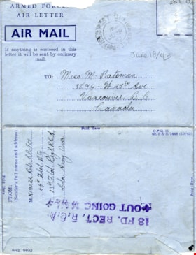
Air mail letter from Brigadeer Colin Fox to May Bateman
https://search.heritageburnaby.ca/link/museumdescription15128
- Repository
- Burnaby Village Museum
- Date
- 18 Jun. 1943
- Collection/Fonds
- E.W. Bateman family fonds
- Description Level
- Item
- Physical Description
- 1 p. (double sided and folded)
- Scope and Content
- Item consists of an air mail letter written by Colin Rhodes Fox of the Royal Canadian Artillery Service to his aunt Marianne "May" Bateman while serving overseas during World War II. Colin Fox served in the 13th Canadian Field Regiment, 44th Canadian Field Battery. In his letter, Colin tells of how…
- Repository
- Burnaby Village Museum
- Collection/Fonds
- E.W. Bateman family fonds
- Description Level
- Item
- Physical Description
- 1 p. (double sided and folded)
- Scope and Content
- Item consists of an air mail letter written by Colin Rhodes Fox of the Royal Canadian Artillery Service to his aunt Marianne "May" Bateman while serving overseas during World War II. Colin Fox served in the 13th Canadian Field Regiment, 44th Canadian Field Battery. In his letter, Colin tells of how he's happy to be back with his regiment after finishing his stay in hospital; thanks May for the chocolates that she sent and how he expects to receive his third stripe which means a raise on top of his Sergeant's pay.
- Accession Code
- BV020.27.16
- Access Restriction
- Restricted access
- Reproduction Restriction
- May be restricted by third party rights
- Date
- 18 Jun. 1943
- Media Type
- Textual Record
- Scan Resolution
- 600
- Scan Date
- 10-Feb-2021
- Scale
- 100
- Notes
- Title based on contents of item
- Address on front of air mail letter reads: "Miss M. Bateman / 3896 W. 25th Ave. / Vancouver B.C. / Canada"
- Return address on front of air mail letter reads: "K 19022 Bdr. C.R.Fox / 44th Fld. Bty. / 13th Fld. Reg't. R.C.A. A.F. / Cdn Army Over"
- Stamp in blue ink on front of air mail letter reads: "13 FD. RECT. R.C.A. / OUT GOING MAIL"
- Circular post mark on front of air mail letter reads: "FIELDRCST_OFFICE / * JU 19/ 43"
Images

Air mail letter from Colin Fox to May Bateman
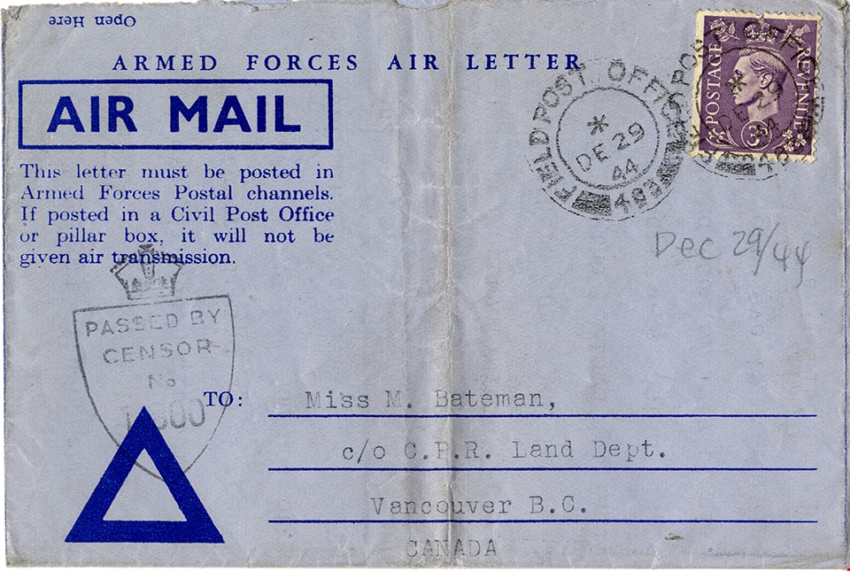
https://search.heritageburnaby.ca/link/museumdescription15145
- Repository
- Burnaby Village Museum
- Date
- 27 Dec. 1944
- Collection/Fonds
- E.W. Bateman family fonds
- Description Level
- Item
- Physical Description
- 1 p. (double sided and folded)
- Scope and Content
- Item consists of a typewritten air mail letter from Sergeant Colin Rhodes Fox of the Royal Canadian Artillery Service to his aunt Marianne "May" Bateman while serving overseas during World War II. Colin Fox served in the 13th Canadian Field Regiment with the 44th and 78th Canadian Field Battery. In…
- Repository
- Burnaby Village Museum
- Collection/Fonds
- E.W. Bateman family fonds
- Description Level
- Item
- Physical Description
- 1 p. (double sided and folded)
- Scope and Content
- Item consists of a typewritten air mail letter from Sergeant Colin Rhodes Fox of the Royal Canadian Artillery Service to his aunt Marianne "May" Bateman while serving overseas during World War II. Colin Fox served in the 13th Canadian Field Regiment with the 44th and 78th Canadian Field Battery. In his letter Colin reflects on how he spent Christmas day and how he discovered that the camp cook came from the Burnaby Lake area.
- Accession Code
- BV020.27.32
- Access Restriction
- Restricted access
- Reproduction Restriction
- May be restricted by third party rights
- Date
- 27 Dec. 1944
- Media Type
- Textual Record
- Scan Resolution
- 600
- Scan Date
- 10-Feb-2021
- Scale
- 100
- Notes
- Title based on contents of item
- Air mail letter is addressed to: "Miss M. Bateman / c/o C.P.R. Land Dept. / Vancouver B.C. / Canada"
- Circular postmark stamps read: "FIELD POST OFFICE 403 / 8 / DE 29 / 44"
- Stamp on outside of air mail letter reads: "PASSED BY / CENSOR / No. / 11800"
- Return address on outside of air mail letter reads: "K19022 Sgt. / C.R.Fox"
Images
Air mail letter from Colin Fox to May Bateman
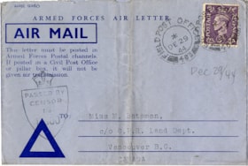
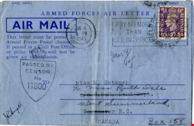
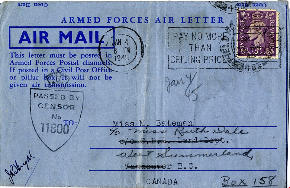
https://search.heritageburnaby.ca/link/museumdescription15146
- Repository
- Burnaby Village Museum
- Date
- 20 Dec. 1944
- Collection/Fonds
- E.W. Bateman family fonds
- Description Level
- Item
- Physical Description
- 1 p. (double sided and folded)
- Scope and Content
- Item consists of a typewritten air mail letter from Sergeant Colin Rhodes Fox of the Royal Canadian Artillery Service to his aunt Marianne "May" Bateman while serving overseas during World War II. Colin Fox served in the 13th Canadian Field Regiment with the 44th and 78th Canadian Field Battery. In…
- Repository
- Burnaby Village Museum
- Collection/Fonds
- E.W. Bateman family fonds
- Description Level
- Item
- Physical Description
- 1 p. (double sided and folded)
- Scope and Content
- Item consists of a typewritten air mail letter from Sergeant Colin Rhodes Fox of the Royal Canadian Artillery Service to his aunt Marianne "May" Bateman while serving overseas during World War II. Colin Fox served in the 13th Canadian Field Regiment with the 44th and 78th Canadian Field Battery. In his letter Colin thanks May for the Christmas parcel she sent; how he received a backlog of letters addressed to him at the convalescent hospital; how the boys that landed on D-Day are taking leave in England; describes a Christmas party that his regiment put on for twenty kids in a nearby town and says that he looks forward to a good Christmas dinner provided there isn't any unexpected action.
- Accession Code
- BV020.27.33
- Access Restriction
- Restricted access
- Reproduction Restriction
- May be restricted by third party rights
- Date
- 20 Dec. 1944
- Media Type
- Textual Record
- Scan Resolution
- 600
- Scan Date
- 10-Feb-2021
- Scale
- 100
- Notes
- Title based on contents of item
- Air mail letter is addressed to: "Miss M. Bateman / c/o Miss Ruth Dale / West Summerland / B.C. / Canada / Box 158" (crossed out address reads: "c/o C.P.R. Land Dept. / Vancouver B.C...")
- Circular postmark stamps read: "JAN 4 / 8 PM / 1945" and " SUMMERLAND / AM / JAN 6 / 45"
- Stamp on outside of air mail letter reads: "PASSED BY / CENSOR / No. / 11800"
- Return address on outside of air mail letter reads: "K19022 Sgt. / C.R.Fox"
Images
Air mail letter from Colin Fox to May Bateman
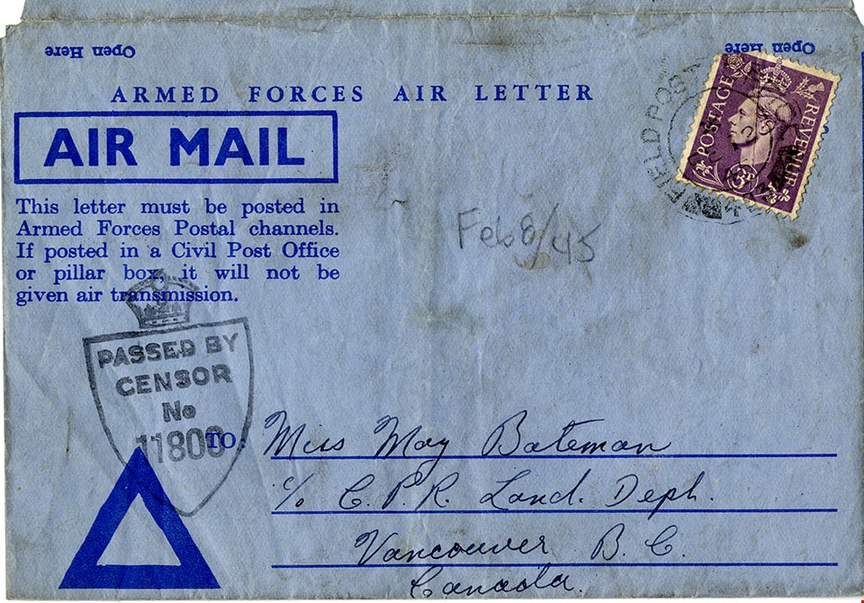
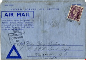
https://search.heritageburnaby.ca/link/museumdescription15147
- Repository
- Burnaby Village Museum
- Date
- 8 Feb. 1945
- Collection/Fonds
- E.W. Bateman family fonds
- Description Level
- Item
- Physical Description
- 1 p. (double sided and folded)
- Scope and Content
- Item consists of a handwritten air mail letter from Sergeant Colin Rhodes Fox of the Royal Canadian Artillery Service to his aunt Marianne "May" Bateman while serving overseas during World War II. Colin Fox served in the 13th Canadian Field Regiment with the 44th and 78th Canadian Field Battery. In…
- Repository
- Burnaby Village Museum
- Collection/Fonds
- E.W. Bateman family fonds
- Description Level
- Item
- Physical Description
- 1 p. (double sided and folded)
- Scope and Content
- Item consists of a handwritten air mail letter from Sergeant Colin Rhodes Fox of the Royal Canadian Artillery Service to his aunt Marianne "May" Bateman while serving overseas during World War II. Colin Fox served in the 13th Canadian Field Regiment with the 44th and 78th Canadian Field Battery. In his letter Colin tells of how his regiment is now in Germany and that he is writing to her from a bombed out cellar in a German town; he tells of his current position as Battery Signal Sergeant and of how he and his regiment observed a German soldier being captured.
- Accession Code
- BV020.27.34
- Access Restriction
- Restricted access
- Reproduction Restriction
- May be restricted by third party rights
- Date
- 8 Feb. 1945
- Media Type
- Textual Record
- Scan Resolution
- 600
- Scan Date
- 10-Feb-2021
- Scale
- 100
- Notes
- Title based on contents of item
- Air mail letter is addressed to: "Miss M. Bateman / c/o C.P.R. Land Dept. / Vancouver B.C. / Canada"
- Circular postmark stamps read: FIELD POST OFFICE.../ FE 12 / 45"
- Stamp on outside of air mail letter reads: "PASSED BY / CENSOR / No. / 11800"
- Return address on outside of air mail letter reads: "K19022 Sgt. / C.R.Fox"
Images