Narrow Results By
Subject
- Accidents - Train Accidents 1
- Advertising Medium - Signs and Signboards 2
- Animals - Cats 1
- Animals - Fowl 1
- Buildings - Commercial 1
- Buildings - Commercial - General Stores 1
- Buildings - Commercial - Service Stations 1
- Buildings - Commercial - Train Stations 1
- Buildings - Public - Post Offices 3
- Buildings - Residential - Houses 1
- Buildings - Schools 1
- Celebrations - Centennials 5

Municipality of Burnaby- Volume XV and Volume XVIII
https://search.heritageburnaby.ca/link/museumdescription8686
- Repository
- Burnaby Village Museum
- Date
- May 1927
- Collection/Fonds
- Burnaby Village Museum Map collection
- Description Level
- File
- Physical Description
- 4 plans on 4 sheets : col. lithographic prints ; 63.5 x 53.5 cm folded to 53 x 31.5 cm
- Scope and Content
- File consists of four pages of plans removed from a bound book containing a series of fire insurance plans of the Municipality of Burnaby. Plan "1520" is part of "GREATER VANCOUVER B.C. / VOLUME XV / Municipality of Burnaby / May 1927" and covers District Lots: 121 and 187. Plann "1521" is part of …
- Repository
- Burnaby Village Museum
- Collection/Fonds
- Burnaby Village Museum Map collection
- Description Level
- File
- Physical Description
- 4 plans on 4 sheets : col. lithographic prints ; 63.5 x 53.5 cm folded to 53 x 31.5 cm
- Material Details
- Scale [1:600] and [1:1200]
- Scope and Content
- File consists of four pages of plans removed from a bound book containing a series of fire insurance plans of the Municipality of Burnaby. Plan "1520" is part of "GREATER VANCOUVER B.C. / VOLUME XV / Municipality of Burnaby / May 1927" and covers District Lots: 121 and 187. Plann "1521" is part of "GREATER VANCOUVER B.C. / VOLUME XV / Municipality of Burnaby / May 1927" and covers District Lots: 121 and 187. Key plan "H" reads: "GREATER VANCOUVER B.C. / VOLUME XVIII / Surveyed _ May 1927 / MUNICIPALITY OF / BURNABY" and covers plans: 1813 to 1822; 1824 to 1832; 1839; 1840; 1853 to 1865 and District Lots: 28; 30; 53; 90 to 93; 95 to 97; 155a; 155b; 155c; 159; 160; 171 to 173. Plan "1801" is part of "GREATER VANCOUVER B.C. / VOLUME XVIII / Municipality of Burnaby / May 1927" and covers District Lot 153.
- Responsibility
- British Columbia Underwriters' Association
- Accession Code
- HV972.111.8
- Access Restriction
- No restrictions
- Reproduction Restriction
- May be restricted by third party rights
- Date
- May 1927
- Media Type
- Cartographic Material
- Historic Neighbourhood
- Fraser Arm (Historic Neighbourhood)
- Vancouver Heights (Historic Neighbourhood)
- East Burnaby (Historic Neighbourhood)
- Edmonds (Historic Neighbourhood)
- Planning Study Area
- Marlborough Area
- Kingsway-Beresford Area
- Windsor Area
- Big Bend Area
- Clinton-Glenwood Area
- Burnaby Heights Area
- Edmonds Area
- Stride Avenue Area
- Scan Resolution
- 400
- Scan Date
- 2021-11-18
- Notes
- Title based on content of plans
- See also BV987.1.70d for revised versions of plans
- Scale is measured 1 inch = 500 feet
Zoomable Images


Municipality of Burnaby - Volume XVI and Volume XVII
https://search.heritageburnaby.ca/link/museumdescription8684
- Repository
- Burnaby Village Museum
- Date
- May 1927
- Collection/Fonds
- Burnaby Village Museum Map collection
- Description Level
- File
- Physical Description
- 4 plans on 4 sheets : col. lithographic prints ; 63.5 x 53.5 cm folded to 53 x 31.5 cm
- Scope and Content
- File consists of four pages of plans removed from a bound book containing a series of fire insurance plans of the Municipality of Burnaby. Page "D" is titled: "GREATER VANCOUVER B.C. / VOLUME XVI / Surveyed _ May 1927 / MUNICIPALITY OF / BURNABY / PLAN DEPT. FIRE BRANCH _ B.C. INSURANCE UNDERWRITE…
- Repository
- Burnaby Village Museum
- Collection/Fonds
- Burnaby Village Museum Map collection
- Description Level
- File
- Physical Description
- 4 plans on 4 sheets : col. lithographic prints ; 63.5 x 53.5 cm folded to 53 x 31.5 cm
- Material Details
- Scale [1:1200] and [1:6000]
- Scope and Content
- File consists of four pages of plans removed from a bound book containing a series of fire insurance plans of the Municipality of Burnaby. Page "D" is titled: "GREATER VANCOUVER B.C. / VOLUME XVI / Surveyed _ May 1927 / MUNICIPALITY OF / BURNABY / PLAN DEPT. FIRE BRANCH _ B.C. INSURANCE UNDERWRITERS ASSN." / KEY PLAN". Plans covered in this "Key Plan" are numbered 1601 to 1626, 1632 and 1651 covering District Lots: 15; 31; 100 to 102; 114; 141 to 144; 147 and 148; 209 to 214. Plan "E" is part of "GREATER VANCOUVER B.C. / VOLUME XVII / Municipality of Burnaby / May 1927" and covers plans: 1701 to 1705; 1711 to 1715; 1723 to 1727; 1729 to 1733; 1737 to 1742 and District Lots: 68 to 74; 80 to 84; 32 to 35 and 38 to 39. Plan marked "F" is a key plan titled: "GREATER VANCOUVER B.C. / VOLUME XVII / Surveyed _ May 1927 / MUNICIPALITY OF / BURNABY and covers plans: 1706 to 1710; 1716 to 1722; 1734 and 1735; 1743 to 1752 and District Lots: 42 to 44; 59; 75 to 80; 83 to 87; 89 to 93 and 130. Plan "1729" is part of "GREATER VANCOUVER B.C. / VOLUME XVII / Municipality of Burnaby / May 1927" and covers District Lots 34 and 35.
- Responsibility
- British Columbia Underwriters' Association
- Accession Code
- HV972.111.6
- Access Restriction
- No restrictions
- Reproduction Restriction
- May be restricted by third party rights
- Date
- May 1927
- Media Type
- Cartographic Material
- Historic Neighbourhood
- Barnet (Historic Neighbourhood)
- Burquitlam (Historic Neighbourhood)
- Central Park (Historic Neighbourhood)
- Burnaby Lake (Historic Neighbourhood)
- Broadview (Historic Neighbourhood)
- Planning Study Area
- Burnaby Mountain Area
- Lyndhurst Area
- Lake City Area
- Cascade-Schou Area
- Garden Village Area
- Douglas-Gilpin Area
- Oakalla Area
- Scan Resolution
- 400
- Scan Date
- 2021-11-18
- Notes
- Title based on content of plans
- See also BV987.1.70d for revised versions of plans
- Scale is measured 1 inch = 500 feet
Zoomable Images


Municipality of Burnaby - Volume XV, Volume XVI, Volume XVII, Volume XVIII
https://search.heritageburnaby.ca/link/museumdescription8685
- Repository
- Burnaby Village Museum
- Date
- May 1927
- Collection/Fonds
- Burnaby Village Museum Map collection
- Description Level
- File
- Physical Description
- 4 plans on 4 sheets : col. lithographic prints ; 63.5 x 53.5 cm folded to 53 x 31.5 cm
- Scope and Content
- File consists of four pages of plans removed from a bound book containing a series of fire insurance plans of the Municipality of Burnaby. Plan "1531" is part of "GREATER VANCOUVER B.C. / VOLUME XV / Municipality of Burnaby / May 1927" and covers District Lots: 116 and 117. Key Plan "C" is part of …
- Repository
- Burnaby Village Museum
- Collection/Fonds
- Burnaby Village Museum Map collection
- Description Level
- File
- Physical Description
- 4 plans on 4 sheets : col. lithographic prints ; 63.5 x 53.5 cm folded to 53 x 31.5 cm
- Material Details
- Scale [1:600] and [1:1200]
- Scope and Content
- File consists of four pages of plans removed from a bound book containing a series of fire insurance plans of the Municipality of Burnaby. Plan "1531" is part of "GREATER VANCOUVER B.C. / VOLUME XV / Municipality of Burnaby / May 1927" and covers District Lots: 116 and 117. Key Plan "C" is part of "GREATER VANCOUVER B.C. / VOLUME XVI / Municipality of Burnaby / May 1927" and covers plans 1623 to 1651 and District Lots: 1 and 2; 4; 6; 8; 10 to 14; 25; 27; 40; 56 to 58; 88 and 89. Plan "1738" is part of "GREATER VANCOUVER B.C. / VOLUME XVII / Municipality of Burnaby / May 1927" and covers District Lots: 34 and 35. Key plan "G" is part of "GREATER VANCOUVER B.C. / VOLUME XVIII / Municipality of Burnaby / May 1927" and covers plans: 1801 to 1813; 1823; 1824; 1833 to 1838; 1841 to 1853 and District Lots: 32; 93; 94; 97 to 99; 149; 150; 152; 155 to 159; 161 to 164.
- Responsibility
- British Columbia Underwriters' Association
- Accession Code
- HV972.111.7
- Access Restriction
- No restrictions
- Reproduction Restriction
- May be restricted by third party rights
- Date
- May 1927
- Media Type
- Cartographic Material
- Historic Neighbourhood
- Central Park (Historic Neighbourhood)
- Fraser Arm (Historic Neighbourhood)
- Alta Vista (Historic Neighbourhood)
- Broadview (Historic Neighbourhood)
- Vancouver Heights (Historic Neighbourhood)
- Burquitlam (Historic Neighbourhood)
- East Burnaby (Historic Neighbourhood)
- Edmonds (Historic Neighbourhood)
- Lozells (Historic Neighbourhood)
- Planning Study Area
- Clinton-Glenwood Area
- Marlborough Area
- Maywood Area
- Windsor Area
- Big Bend Area
- Garden Village Area
- Willingdon Heights Area
- West Central Valley Area
- Cariboo-Armstrong Area
- Lyndhurst Area
- Cameron Area
- Lake City Area
- Edmonds Area
- Second Street Area
- Sperling-Broadway Area
- Lakeview-Mayfield Area
- Scan Resolution
- 400
- Scan Date
- 2021-11-18
- Notes
- Title based on content of plans
- See also BV987.1.70d for revised versions of plans
- Scale is measured 1 inch = 500 feet
Zoomable Images

Municipality of Burnaby - Volume XV, Volume XVI, Volume XVII, Volume XVIII, May 1927
Zoom into Image

Municipality of Burnaby - Volume XV and Volume XVIII
https://search.heritageburnaby.ca/link/museumdescription8680
- Repository
- Burnaby Village Museum
- Date
- May 1927
- Collection/Fonds
- Burnaby Village Museum Map collection
- Description Level
- File
- Physical Description
- 4 plans on 4 sheets : col. lithographic prints ; 63.5 x 53.5 cm folded to 53 x 31.5 cm
- Scope and Content
- File consists of four pages of plans removed from a bound book containing a series of fire insurance plans of the Municipality of Burnaby. The first two pages are numbered "A" and "B" and are key plans from "GREATER VANCOUVER B.C. / VOLUME XV / Surveyed _ May 1927 / MUNICIPALITY OF / BURNABY", "PLA…
- Repository
- Burnaby Village Museum
- Collection/Fonds
- Burnaby Village Museum Map collection
- Description Level
- File
- Physical Description
- 4 plans on 4 sheets : col. lithographic prints ; 63.5 x 53.5 cm folded to 53 x 31.5 cm
- Material Details
- Scales [1:1200] and [1:6000]
- Scope and Content
- File consists of four pages of plans removed from a bound book containing a series of fire insurance plans of the Municipality of Burnaby. The first two pages are numbered "A" and "B" and are key plans from "GREATER VANCOUVER B.C. / VOLUME XV / Surveyed _ May 1927 / MUNICIPALITY OF / BURNABY", "PLAN DEPT. FIRE BRANCH _ B.C. INSURANCE UNDERWRITERS ASSN.". Key Plan "B" covers plans: 1505; 1506; 1512 to 1516; 1540 to 1544; 1550 to 1557 and District Lots: 129 to 132; 135 to 138; 205 to 208 and 215 to 218. Key Plan "A" covers plans: 1501 to 1504; 1507 to 1511; 1517 to 1525; 1531 to 1539; 1545 to 1550 and District Lots: 116 to 127 and 186 to 189. Plan "1806" is part of "GREATER VANCOUVER B.C. / VOLUME XVIII / Municipality of Burnaby / May, 1927" and covers District Lot 153. Plan "1807" is from "GREATER VANCOUVER B.C. / VOLUME XVIII / Municipality of Burnaby / May, 1927" and covers District Lots: 99,149 and 152.
- Responsibility
- British Columbia Underwriters' Association
- Accession Code
- HV972.111.2
- Access Restriction
- No restrictions
- Reproduction Restriction
- May be restricted by third party rights
- Date
- May 1927
- Media Type
- Cartographic Material
- Historic Neighbourhood
- Vancouver Heights (Historic Neighbourhood)
- Lochdale (Historic Neighbourhood)
- Capitol Hill (Historic Neighbourhood)
- Central Park (Historic Neighbourhood)
- Alta Vista (Historic Neighbourhood)
- Planning Study Area
- Burnaby Heights Area
- Sperling-Broadway Area
- Lochdale Area
- Parkcrest-Aubrey Area
- Westridge Area
- Willingdon Heights Area
- Capitol Hill Area
- Maywood Area
- Marlborough Area
- Scan Resolution
- 400
- Scan Date
- 2021-11-18
- Notes
- Title based on content of plans
- Scales are measured 1 inch = 100 feet and 1 inch = 500 feet
- See also BV987.1.70d for revised versions of plans
Zoomable Images


![The Bird's Paradise, Vancouver, BC, [between 1930 and 1945] thumbnail](/media/hpo/_Data/_BVM_Images/1985/1985_6012_0001_001.jpg?width=280)
The Bird's Paradise, Vancouver, BC
https://search.heritageburnaby.ca/link/museumdescription3221
- Repository
- Burnaby Village Museum
- Date
- [between 1930 and 1945]
- Collection/Fonds
- Burnaby Village Museum Photograph collection
- Description Level
- Item
- Physical Description
- 1 photograph : b&w postcard hand-tinted into col.
- Scope and Content
- Photographic postcard of an unidentified man in tweed suit smoking a pipe.There are birds resting on his head, on his pipe and hand, on his shoulder and his forearm. The birds on his hand have been coloured red, and the others are coloured yellow. A caption to the photograph reads: The Birds' Para…
- Repository
- Burnaby Village Museum
- Collection/Fonds
- Burnaby Village Museum Photograph collection
- Description Level
- Item
- Physical Description
- 1 photograph : b&w postcard hand-tinted into col.
- Material Details
- inscribed in the original negative, printed on recto, c. r. "The Birds' Paradise,/ Vancouver, B.C./ No. 2.", l.l. "[copyright c with circle]" printed on verso, t. "MADE IN CANADA BY THE GOWEN, SUTTON CO. LTD., VANCOUVER, B. C."
- Scope and Content
- Photographic postcard of an unidentified man in tweed suit smoking a pipe.There are birds resting on his head, on his pipe and hand, on his shoulder and his forearm. The birds on his hand have been coloured red, and the others are coloured yellow. A caption to the photograph reads: The Birds' Paradise / Vancouver, B.C. / No. 2.
- Geographic Access
- Vancouver
- Accession Code
- BV985.6012.1
- Access Restriction
- No restrictions
- Reproduction Restriction
- No known restrictions
- Date
- [between 1930 and 1945]
- Media Type
- Photograph
- Scan Resolution
- 600
- Scan Date
- 2024-02-27
- Photographer
- Gowen Sutton Company Limited
- Notes
- Title based on contents of postcard
Images
![The Bird's Paradise, Vancouver, BC, [between 1930 and 1945] thumbnail](/media/hpo/_Data/_BVM_Images/1985/1985_6012_0001_001.jpg)
![George and Harriet Jeffery, [between 1910 and 1913] thumbnail](/media/hpo/_Data/_BVM_Images/1971/1971_0144_0007_001.jpg?width=280)
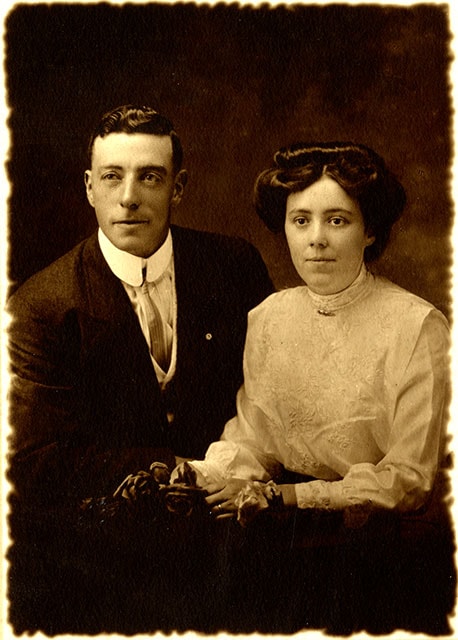
George and Harriet Jeffery
https://search.heritageburnaby.ca/link/museumdescription40
- Repository
- Burnaby Village Museum
- Date
- [between 1910 and 1913]
- Collection/Fonds
- Burnaby Village Museum Photograph collection
- Description Level
- Item
- Physical Description
- 1 photograph : sepia ; 9.9 x 14.0 cm photogravure on paper 21.5 x 16.4 cm
- Scope and Content
- Photogravure of George Jeffery and his wife Harriet. George Jeffery is dressed in a dark suit with light vest and striped shirt, a celluloid collar, a narrow striped necktie, and a pin in the left lapel. Harriet Jeffery is wearing a white trimmed and embroidered Gibson-style blouse, with a pin at t…
- Repository
- Burnaby Village Museum
- Collection/Fonds
- Burnaby Village Museum Photograph collection
- Description Level
- Item
- Physical Description
- 1 photograph : sepia ; 9.9 x 14.0 cm photogravure on paper 21.5 x 16.4 cm
- Scope and Content
- Photogravure of George Jeffery and his wife Harriet. George Jeffery is dressed in a dark suit with light vest and striped shirt, a celluloid collar, a narrow striped necktie, and a pin in the left lapel. Harriet Jeffery is wearing a white trimmed and embroidered Gibson-style blouse, with a pin at the neck. She is holding flowers as studio props. According to the earlier catalogue record from 1976, the photogravure was made shortly after the couple's wedding. Embossed on the photogravure, front, lower left: "WJC [monogram]" and lower right: "Carpenter / Vancouver. B.C." Inscribed in pencil, back of the photogravure: "5699 / George / Jeffry. [sic] / 4531 Burke St. / Vancouver / B.C."
- Geographic Access
- Vancouver
- Accession Code
- HV971.144.7
- Access Restriction
- No restrictions
- Reproduction Restriction
- No known restrictions
- Date
- [between 1910 and 1913]
- Media Type
- Photograph
- Scan Resolution
- 600
- Scan Date
- 2023-03-28
- Photographer
- Carpenter, William Jefferson
- Notes
- Title based on contents of photograph
Images
![George and Harriet Jeffery, [between 1910 and 1913] thumbnail](/media/hpo/_Data/_BVM_Images/1971/1971_0144_0007_001.jpg)
![Gilmore Avenue School, [192-] thumbnail](/media/hpo/_Data/_BVM_Images/1985/1985_0100_0004_001.jpg?width=280)
Gilmore Avenue School
https://search.heritageburnaby.ca/link/museumdescription2992
- Repository
- Burnaby Village Museum
- Date
- [192-]
- Collection/Fonds
- Burnaby Village Museum Photograph collection
- Description Level
- Item
- Physical Description
- 1 photograph : b&w postcard ; 8.9 x 13.9 cm
- Scope and Content
- Photograph of the front of the Gilmore Avenue School. Note the doors and stairways added on to the side of the building, and the electric power pole and the power lines in front of the school building. Inscribed in the original negative and printed on the bottom front right of the photograph: "Gil…
- Repository
- Burnaby Village Museum
- Collection/Fonds
- Burnaby Village Museum Photograph collection
- Description Level
- Item
- Physical Description
- 1 photograph : b&w postcard ; 8.9 x 13.9 cm
- Scope and Content
- Photograph of the front of the Gilmore Avenue School. Note the doors and stairways added on to the side of the building, and the electric power pole and the power lines in front of the school building. Inscribed in the original negative and printed on the bottom front right of the photograph: "Gilmore Ave. School / Van. Heights. / Vancouver, B.C." Printed on the bottom front left of the postcard: "J.M. Henton. Photographer, Vancouver, B.C."
- Subjects
- Buildings - Schools
- Geographic Access
- Gilmore Avenue
- Street Address
- 50 Gilmore Avenue
- Accession Code
- BV985.100.4
- Access Restriction
- No restrictions
- Reproduction Restriction
- No known restrictions
- Date
- [192-]
- Media Type
- Photograph
- Historic Neighbourhood
- Vancouver Heights (Historic Neighbourhood)
- Planning Study Area
- Burnaby Heights Area
- Related Material
- For another postcard of the same image, see HV983.70.2 stored with the postcards.
- Scan Resolution
- 600
- Scan Date
- 2024-02-02
- Photographer
- Henton, John Morse
- Notes
- Title based on contents of photograph
Images
![Gilmore Avenue School, [192-] thumbnail](/media/hpo/_Data/_BVM_Images/1985/1985_0100_0004_001.jpg)
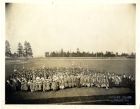
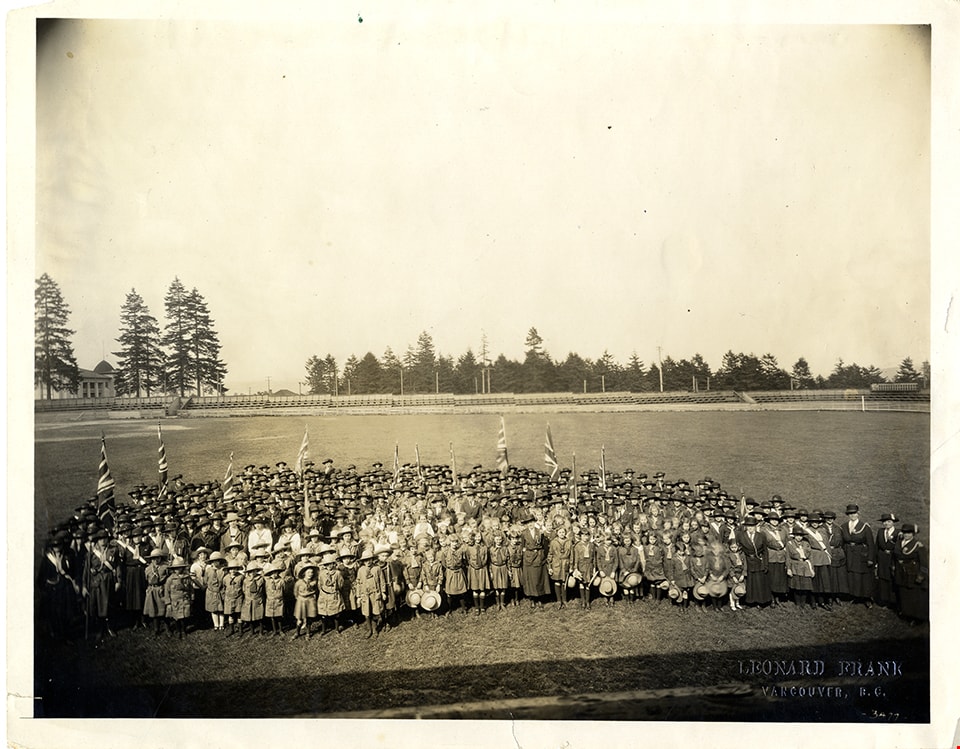
Girl Guides at Queen's Park
https://search.heritageburnaby.ca/link/museumdescription4904
- Repository
- Burnaby Village Museum
- Date
- 1923
- Collection/Fonds
- Burnaby Girl Guides fonds
- Description Level
- Item
- Physical Description
- 1 photograph : sepia ; 21.5 x 25.5 cm
- Scope and Content
- Photograph of a large group of Girl Guides dressed in uniform gathered together for a group photograph on the field at Queen's Park, New Westminster. The photograph appears to have been taken from above.
- Repository
- Burnaby Village Museum
- Collection/Fonds
- Burnaby Girl Guides fonds
- Description Level
- Item
- Physical Description
- 1 photograph : sepia ; 21.5 x 25.5 cm
- Scope and Content
- Photograph of a large group of Girl Guides dressed in uniform gathered together for a group photograph on the field at Queen's Park, New Westminster. The photograph appears to have been taken from above.
- Names
- Girl Guides of Canada
- Geographic Access
- New Westminster
- Accession Code
- BV015.35.262
- Access Restriction
- No restrictions
- Reproduction Restriction
- No known restrictions
- Date
- 1923
- Media Type
- Photograph
- Scan Resolution
- 600
- Scan Date
- January 6, 2021
- Scale
- 100
- Photographer
- Frank, Leonard
- Notes
- Title based on contents of photograph
- Embossment in lower right corner of photograph reads: "Leonard Frank / Vancouver, B.C."
- Oval stamp on verso of photograph reads: "Leonard Frank / Photographic Artist / 533 Granville St. / Sey. 1029 Vancouver, B.C."
- Note in ink on verso of photograph reads: "West_1923"
- Note in black grease pencil on verso of photograph reads:"No 3477"
- Photograph is a part of scrapbook "Burnaby Girl Guides. -- [1914]-1969, predominant ca. 1920" (BV.015.35.164)
Images

Municipality of Burnaby - Volume XV and Volume XVIII
https://search.heritageburnaby.ca/link/museumdescription8681
- Repository
- Burnaby Village Museum
- Date
- May 1927
- Collection/Fonds
- Burnaby Village Museum Map collection
- Description Level
- File
- Physical Description
- 4 plans on 4 sheets : col. lithographic prints, ms. annotations in blue ink ; 63.5 x 53.5 cm folded to 53 x 31.5 cm
- Scope and Content
- File consists of four pages of plans removed from a bound book containing a series of fire insurance plans of the Municipality of Burnaby. Plan "1507" and plan "1517" are from "GREATER VANCOUVER B.C. / VOLUME XV / Municipality of Burnaby / May, 1927". Plan "1507" covers District Lot 186 and plan "1…
- Repository
- Burnaby Village Museum
- Collection/Fonds
- Burnaby Village Museum Map collection
- Description Level
- File
- Physical Description
- 4 plans on 4 sheets : col. lithographic prints, ms. annotations in blue ink ; 63.5 x 53.5 cm folded to 53 x 31.5 cm
- Material Details
- Scale [1:600] and [1:1200]
- Scope and Content
- File consists of four pages of plans removed from a bound book containing a series of fire insurance plans of the Municipality of Burnaby. Plan "1507" and plan "1517" are from "GREATER VANCOUVER B.C. / VOLUME XV / Municipality of Burnaby / May, 1927". Plan "1507" covers District Lot 186 and plan "1517" covers District Lot 116. Plan "1804" and plan "1805" are from "GREATER VANCOUVER B.C. / VOLUME XVIII / Municipality of Burnaby / May, 1927". Plans "1804" and "1805" cover District Lot 153.
- Responsibility
- British Columbia Underwriters' Association
- Accession Code
- HV972.111.3
- Access Restriction
- No restrictions
- Reproduction Restriction
- May be restricted by third party rights
- Date
- May 1927
- Media Type
- Cartographic Material
- Historic Neighbourhood
- Central Park (Historic Neighbourhood)
- Vancouver Heights (Historic Neighbourhood)
- Planning Study Area
- Maywood Area
- Willingdon Heights Area
- Scan Resolution
- 400
- Scan Date
- 2021-11-18
- Notes
- Title based on content of plans
- See also BV987.1.70d for revised versions of plans
- Scale is measured 1 inch = 100 feet
Images


![Municipality of Burnaby - Volume XV and Volume XVIII, 1927-[1940] thumbnail](/media/hpo/_Data/_BVM_Artifacts/1972/1972_0111_0004_003.jpg?width=280)
Municipality of Burnaby - Volume XV and Volume XVIII
https://search.heritageburnaby.ca/link/museumdescription8682
- Repository
- Burnaby Village Museum
- Date
- 1927-[1940]
- Collection/Fonds
- Burnaby Village Museum Map collection
- Description Level
- File
- Physical Description
- 4 plans on 4 sheets: col. lithographic prints ; 63.5 x 53.5 cm folded to 53 x 31.5 cm
- Scope and Content
- File consists of four pages of plans removed from a bound book containing a series of fire insurance plans of the Municipality of Burnaby. Plan "1518" and "1519" are from "GREATER VANCOUVER B.C. / VOLUME XV / Municipality of Burnaby / May, 1927". Plan "1518" covers District Lot 116 and Plan "1519"…
- Repository
- Burnaby Village Museum
- Collection/Fonds
- Burnaby Village Museum Map collection
- Description Level
- File
- Physical Description
- 4 plans on 4 sheets: col. lithographic prints ; 63.5 x 53.5 cm folded to 53 x 31.5 cm
- Material Details
- Scale [1:600]
- Scope and Content
- File consists of four pages of plans removed from a bound book containing a series of fire insurance plans of the Municipality of Burnaby. Plan "1518" and "1519" are from "GREATER VANCOUVER B.C. / VOLUME XV / Municipality of Burnaby / May, 1927". Plan "1518" covers District Lot 116 and Plan "1519" covers District Lot 121. Plan "1802" and plan "1803" are from "GREATER VANCOUVER B.C. / VOLUME XVIII / Municipality of Burnaby / May, 1927". Both plans "1802" and "1803" cover District Lot 153.
- Responsibility
- British Columbia Underwriters' Association
- Accession Code
- HV972.111.4
- Access Restriction
- No restrictions
- Reproduction Restriction
- May be restricted by third party rights
- Date
- 1927-[1940]
- Media Type
- Cartographic Material
- Historic Neighbourhood
- Vancouver Heights (Historic Neighbourhood)
- Central Park (Historic Neighbourhood)
- Planning Study Area
- Willingdon Heights Area
- Marlborough Area
- Scan Resolution
- 400
- Scan Date
- 2021-11-18
- Notes
- Title based on content of plans
- See also BV987.1.70d for revised versions of plans
- Scale is measured 1 inch = 50 feet
- Contact Burnaby Village Museum to access plans 1518 and 1519 (these plans have revisions on top - date of revisions is uncertain)
Images
![Municipality of Burnaby - Volume XV and Volume XVIII, 1927-[1940] thumbnail](/media/hpo/_Data/_BVM_Artifacts/1972/1972_0111_0004_003.jpg)


Municipality of Burnaby - Volume XVIII and Volume XIX
https://search.heritageburnaby.ca/link/museumdescription8683
- Repository
- Burnaby Village Museum
- Date
- May 1927
- Collection/Fonds
- Burnaby Village Museum Map collection
- Description Level
- File
- Physical Description
- 2 plans on 2 sheets : col. lithographic prints ; 63.5 x 53.5 cm folded to 53 x 31.5 cm
- Scope and Content
- File consists of two pages of plans removed from a bound book containing a series of fire insurance plans of the Municipality of Burnaby. Plan "1832" is from "GREATER VANCOUVER B.C. / VOLUME XVIII / Municipality of Burnaby / May, 1927" and covers District Lots: 98 and 28. Plan "K" is part of a key …
- Repository
- Burnaby Village Museum
- Collection/Fonds
- Burnaby Village Museum Map collection
- Description Level
- File
- Physical Description
- 2 plans on 2 sheets : col. lithographic prints ; 63.5 x 53.5 cm folded to 53 x 31.5 cm
- Material Details
- Scale [1:1200] to [1:6000]
- Scope and Content
- File consists of two pages of plans removed from a bound book containing a series of fire insurance plans of the Municipality of Burnaby. Plan "1832" is from "GREATER VANCOUVER B.C. / VOLUME XVIII / Municipality of Burnaby / May, 1927" and covers District Lots: 98 and 28. Plan "K" is part of a key plan "GREATER VANCOUVER B.C. / Surveyed VOLUME XIX May 1927 / MUNICIPALITY OF / BURNABY / PLAN DEPT. British Columbia Ins. Underwriters Association / FIRE BRANCH / KEY PLAN", "Scale 500 FT = 1 INCH / FOR REPORT SEE VOL. XV" covering plans: 1901 to 1914 and District Lots: 161; 164 to 167; 155c; 155; 172 and 173.
- Responsibility
- British Columbia Underwriters' Association
- Accession Code
- HV972.111.5
- Access Restriction
- No restrictions
- Reproduction Restriction
- May be restricted by third party rights
- Date
- May 1927
- Media Type
- Cartographic Material
- Historic Neighbourhood
- East Burnaby (Historic Neighbourhood)
- Central Park (Historic Neighbourhood)
- Fraser Arm (Historic Neighbourhood)
- Alta Vista (Historic Neighbourhood)
- Planning Study Area
- Windsor Area
- Marlborough Area
- Second Street Area
- Big Bend Area
- Sussex-Nelson Area
- Scan Resolution
- 400
- Scan Date
- 2021-11-18
- Notes
- Title based on content of plans
- See also BV987.1.70d for revised versions of plans
- Scale is measured 1 inch = 500 feet
Zoomable Images

![Portrait of E.W. Martin, [1959] thumbnail](/media/hpo/_Data/_BVM_Images/2019/2019_0037_0013_001.jpg?width=280)
Portrait of E.W. Martin
https://search.heritageburnaby.ca/link/museumdescription15040
- Repository
- Burnaby Village Museum
- Date
- [1959]
- Collection/Fonds
- Elmer Wilson Martin fonds
- Description Level
- Item
- Physical Description
- 1 photograph : b&w ; 25 x 20 cm
- Scope and Content
- Photograph portrait of Elmer Martin Wilson taken at Cathay Studio, Vancouver, B.C.
- Repository
- Burnaby Village Museum
- Collection/Fonds
- Elmer Wilson Martin fonds
- Description Level
- Item
- Physical Description
- 1 photograph : b&w ; 25 x 20 cm
- Scope and Content
- Photograph portrait of Elmer Martin Wilson taken at Cathay Studio, Vancouver, B.C.
- Names
- Martin, Elmer Wilson
- Accession Code
- BV019.37.13
- Access Restriction
- No restrictions
- Reproduction Restriction
- No known restrictions
- Date
- [1959]
- Media Type
- Photograph
- Related Material
- See also BV019.37.8
- Scan Resolution
- 600
- Scan Date
- February 4, 2021
- Scale
- 100
- Photographer
- Cathay Studio
- Notes
- Title based on contents of photograph
- Photograph was removed from portfolio matt frame 27 x 44 cm. Front cover of matt includes gold lettering which reads: "Cathay / Studio / Vancouver, B.C."
- See also photograph of Elmer Wilson Martin - BV019.37.8
Images
![Portrait of E.W. Martin, [1959] thumbnail](/media/hpo/_Data/_BVM_Images/2019/2019_0037_0013_001.jpg)
![Post Office, Vancouver BC, [between 1908 and 1911] thumbnail](/media/hpo/_Data/_BVM_Images/1972/1972_0050_0004_001.jpg?width=280)
Post Office, Vancouver BC
https://search.heritageburnaby.ca/link/museumdescription1065
- Repository
- Burnaby Village Museum
- Date
- [between 1908 and 1911]
- Collection/Fonds
- Burnaby Village Museum Photograph collection
- Description Level
- Item
- Physical Description
- 1 photograph : sepia ; 8.8 x 10.2 cm, mounted on paper 13.5 x 12.2 cm
- Scope and Content
- Photograph of the post office near the downtown Vancouver waterfront. The north shore can be seen faintly across Burrard Inlet in the background. Inscribed on the negative, printed on the photograph, lower left: "Post Office / Vancouver B.C."
- Repository
- Burnaby Village Museum
- Collection/Fonds
- Burnaby Village Museum Photograph collection
- Description Level
- Item
- Physical Description
- 1 photograph : sepia ; 8.8 x 10.2 cm, mounted on paper 13.5 x 12.2 cm
- Material Details
- inscribed on the negative, printed on the photograph, l.l., "POST OFFICE/ VANCOUVER B.C."
- Scope and Content
- Photograph of the post office near the downtown Vancouver waterfront. The north shore can be seen faintly across Burrard Inlet in the background. Inscribed on the negative, printed on the photograph, lower left: "Post Office / Vancouver B.C."
- Subjects
- Buildings - Public - Post Offices
- Geographic Access
- Vancouver
- Accession Code
- HV972.50.4
- Access Restriction
- No restrictions
- Reproduction Restriction
- No known restrictions
- Date
- [between 1908 and 1911]
- Media Type
- Photograph
- Scan Resolution
- 600
- Scan Date
- 2023-03-28
- Photographer
- Dean, H.M.
Images
![Post Office, Vancouver BC, [between 1908 and 1911] thumbnail](/media/hpo/_Data/_BVM_Images/1972/1972_0050_0004_001.jpg)
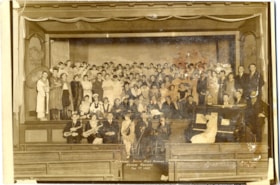
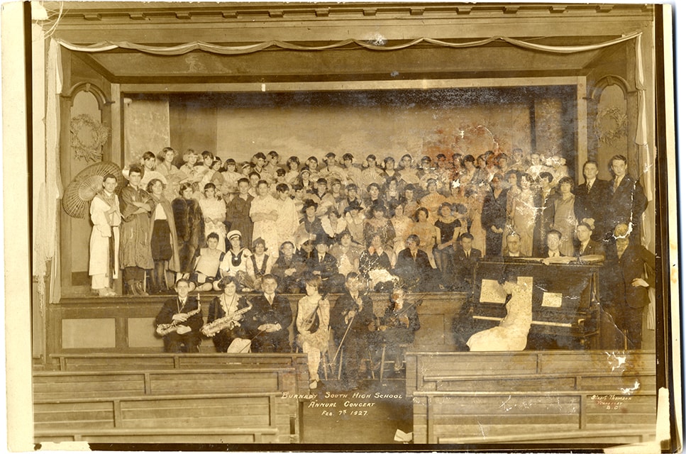
South Burnaby High School Annual concert
https://search.heritageburnaby.ca/link/museumdescription3881
- Repository
- Burnaby Village Museum
- Date
- 7 Feb. 1927
- Collection/Fonds
- Burnaby Village Museum Photograph collection
- Description Level
- Item
- Physical Description
- 1 photograph : sepia ; 26 x 17.5 cm
- Scope and Content
- Photograph of students and participants in the Burnaby South High School annual concert held at the Burnaby Public Hall located next to the Municipal Hall at Edmonds and Kingsway. Six musicians are seated in front of the stage and five rows of performers are arranged on stage. Elinor Winter is iden…
- Repository
- Burnaby Village Museum
- Collection/Fonds
- Burnaby Village Museum Photograph collection
- Description Level
- Item
- Physical Description
- 1 photograph : sepia ; 26 x 17.5 cm
- Scope and Content
- Photograph of students and participants in the Burnaby South High School annual concert held at the Burnaby Public Hall located next to the Municipal Hall at Edmonds and Kingsway. Six musicians are seated in front of the stage and five rows of performers are arranged on stage. Elinor Winter is identified sitting second from the left in the front row. "Burnaby South High School / Annual Concert / Feb. 7th 1927" and "Stuart Thomson / Vancouver / B.C." printed in image at center of bottom and at the lower right corner.
- Subjects
- Performances - Concerts
- Geographic Access
- Kingsway
- Street Address
- 7252 Kingsway
- Accession Code
- BV008.59.27
- Access Restriction
- No restrictions
- Reproduction Restriction
- No known restrictions
- Date
- 7 Feb. 1927
- Media Type
- Photograph
- Historic Neighbourhood
- Edmonds (Historic Neighbourhood)
- Planning Study Area
- Stride Avenue Area
- Related Material
- Similar photograph as City of Burnaby Archives Item no. 485-063
- Scan Resolution
- 600
- Scan Date
- 2022-03-08
- Photographer
- Thomson, Stuart
- Notes
- Title based on contents of photograph
- Note in white on bottom of photograph reads: "Burnaby South High School / Annual Concert / Feb. 7th 1927"_"Stuart Thomson / Vancouver / B.C."
- Handwritten note in pencil on verso of photograph reads: "Elinor May. / I think Mom is / first row on stage - / Horn pipe Costume"
Images
![Survey and Subdivision plans in New Westminster District Group 1 – Burnaby, Port Moody, [1862-1908] thumbnail](/media/hpo/_Data/_BVM_Cartographic_Material/1977/1977_0093_0026a_001.jpg?width=280)
Survey and Subdivision plans in New Westminster District Group 1 – Burnaby, Port Moody
https://search.heritageburnaby.ca/link/museumdescription6995
- Repository
- Burnaby Village Museum
- Date
- [1862-1908]
- Collection/Fonds
- Burnaby Village Museum Map collection
- Description Level
- File
- Physical Description
- 9 plans : 6 plans : black ink on paper ; 57 x 36.5 cm or smaller + 1 plan : black ink and grahite on paper ; 46.5 x 49 cm + 1 plan : blueprint on paper ; 15.5 x 19.5 cm + cm + 1 plan : graphite on paper ; 25 x 17 cm ; mounted on both sides of board 76 x 102 cm
- Scope and Content
- Item consists of a large board of four New Westminster District subdivision plans mounted on one side and five New Westminster District subdivision plans mounted on the other side. Side A: 1. "Plan / of Subdivision / of a Portion / of / Lot 87 / Group One / New Westminster District / Scale 4 chs…
- Repository
- Burnaby Village Museum
- Collection/Fonds
- Burnaby Village Museum Map collection
- Description Level
- File
- Physical Description
- 9 plans : 6 plans : black ink on paper ; 57 x 36.5 cm or smaller + 1 plan : black ink and grahite on paper ; 46.5 x 49 cm + 1 plan : blueprint on paper ; 15.5 x 19.5 cm + cm + 1 plan : graphite on paper ; 25 x 17 cm ; mounted on both sides of board 76 x 102 cm
- Material Details
- Scales [between 1:792 and 1:3600]
- Index number on edge of board reads: "26"
- Scope and Content
- Item consists of a large board of four New Westminster District subdivision plans mounted on one side and five New Westminster District subdivision plans mounted on the other side. Side A: 1. "Plan / of Subdivision / of a Portion / of / Lot 87 / Group One / New Westminster District / Scale 4 chs = 1 in". Plan is stamped: "Albert J. Hill, Civil Engineer / and / Provincial Land Surveyor, / New Westminster, / B.C." and intialed by: "RB" [sic] (in blue pencil crayon). Names two of the subdivisons of District Lot 87 are identified as, "L.E. Sprott" and "John Ledger". (Geographic location: Burnaby) 2. "Plan of Subdivision / of / Portions of / Lot 136, 131 and Lots 44 and 78 Gr.1 / New Westminster District / Scale 300 ft = 1 inch". Annotation above title reads: "No. 901 / Deposited in Land Registry Office / New Westminster / Aug. 19th 1905 / Charles S. Keith D. Reg." Annotations and signatures at bottom of plan read: "I, William Nelson Draper, / W.H.R. Collister / Charles E. Perkins / E.B. Morgan / make / Surveys / correct / representation / upon / the / Land Registry Act / (sgd) W.N. Draper, P.L.S.". Plan includes a handwritten title: "Lots 136, 131, 44 & 78" and is initialed: "RB" [sic] (in blue pencil crayon) (Geographic location: Burnaby) 3. "Survey / of / a Portion / of / Lot 95, Gr.1 / Scale 1 ch = 1in." Plan is stamped: "Albert J. Hill, Civil Engineer / and / Provincial Land Surveyor, / New Westminster, / B.C." and is initialed : "RB" [sic] (in blue pencil crayon) (Geographic location: Burnaby) 4. Blueprint plan of "Lot 396. Group One." with Scale : 3 chs = 1 in. A two acre portion of District Lot 396 is filled in with red ink." Plan is signed by "Albert J. Hill / B.C.L.S." (Geographic location: Port Moody) Side B: 1. Plan titled "District Lot 92 / Burnaby / Municipality / for sale by / Mahon / McFarland & / Mahon Ltd. / Vancouver, B.C. / Scale : 4 chains to one inch". District Lot 92 is subdivided into 161 lots and identifies roads: Norwich Road, Pole Line Road, Oakland Road, Stanley Road, Burford Road, Dalhousie Road, Brantford Road, Colborne Road, Roberts Road, Vancouver & Westminster Road, B.C. Electric Railway, Gilley Stn. and Burnaby (Power House). The bottom of the plan reads: "G.S. Dawson, P.LS. Vancouver, B.C." (Geographic location: Burnaby) 2. "Plan / of Subdivision / of a Portion / of / Lot 29 / Group 1 / New Westminster District / Scale 2 chs = 1 in". Plan is stamped: "Albert J. Hill, Civil Engineer / and / Provincial Land Surveyor, / New Westminster, / B.C." and is initialed by: "RB" [sic] (in blue pencil crayon) (Geographic location: Burnaby) 3. Small handrawn plan (no title) identifying "Lot 84 / Hydes, Claim" at the centre surrounded by lots and features identified as: "Lot 85", "Lot 93", "Lot 94", "Lot 32", "Lot 82", "Lot 83", "Lot 79", "swamp" and a "Small Lake" (Burnaby Lake). Identifying marks in the right corner of the plan read: "Page 13 / Surveyed by G. Turner / May 62". Plan also includes surveyor's bearing measurements and trails to "Small Lake" (Burnaby Lake). (Geographic location: Burnaby) 4. Untitled plan showing District Lots west of North Road and north of Burnaby Lake including: Lots 2, 4, 6, 8, 15, 10, 56, 148, 57, 58, 40. and Lots 3, 5, 7 east of North Road (Coquitlam). Lots in Burnaby are identifed for timber including: "Heavily Timbered" (Lot 57), " "Some Fir and Cedar" (Lot 40), "Splendid Fir and Cedar" (Lot 143), "Heavy Fir etc" (Lots 143 and 148), " "Fine Cedar" (Lot 15), "Rough Light Timber" (Lot 56). Other features identified at the lower portion of the plan include "Burnaby Lake" and "Brunette River". (Geographic location: Burnaby) 5. Untitled plan drawn in graphite showing sections of District Lot 85 south of Burnaby Lake and north of Hazsard Road. Plan is signed: "Albert J. Hill / B.C.L.S." and dated "12/26/08". Plan is initialed by: "RB" [sic] (in blue pencil crayon) (Geographic location: Burnaby)
- Publisher
- Mahon, McFarland & Mahon Ltd
- Accession Code
- HV977.93.26
- Access Restriction
- No restrictions
- Reproduction Restriction
- No known restrictions
- Date
- [1862-1908]
- Media Type
- Cartographic Material
- Historic Neighbourhood
- Burnaby Lake (Historic Neighbourhood)
- Burquitlam (Historic Neighbourhood)
- Planning Study Area
- Burnaby Lake Area
- Scan Resolution
- 300
- Scale
- 72
- Notes
- Title based on contents of file
- Scale is measured in chains and feet. (One chain equals 792 inches)
- The term "Lot" can also refer to a "District Lot”
Images
![Survey and Subdivision plans in New Westminster District Group 1 – Burnaby, Port Moody, [1862-1908] thumbnail](/media/hpo/_Data/_BVM_Cartographic_Material/1977/1977_0093_0026a_001.jpg)


![Alice V. Sparman Sanders, [1946] thumbnail](/media/hpo/_Data/_BVM_Images/2018/2018_0034_0013_001.jpg?width=280)
Alice V. Sparman Sanders
https://search.heritageburnaby.ca/link/museumdescription9888
- Repository
- Burnaby Village Museum
- Date
- [1946]
- Collection/Fonds
- Gerald F. Sanders and Alice Sparman Sanders fonds
- Description Level
- Item
- Physical Description
- 1 photograph : b&w ; 16.5 x 11.5 cm (sight) in mat 26 x 37.5 cm (folded)
- Scope and Content
- Studio portrait of Alice V. Sparman Sanders.
- Repository
- Burnaby Village Museum
- Collection/Fonds
- Gerald F. Sanders and Alice Sparman Sanders fonds
- Description Level
- Item
- Physical Description
- 1 photograph : b&w ; 16.5 x 11.5 cm (sight) in mat 26 x 37.5 cm (folded)
- Material Details
- Photograph is mounted in portrait studio folder with "WAND / VANCOUVER, B.C." printed on front in grey
- Scope and Content
- Studio portrait of Alice V. Sparman Sanders.
- Accession Code
- BV018.34.13
- Access Restriction
- No restrictions
- Reproduction Restriction
- No known restrictions
- Date
- [1946]
- Media Type
- Photograph
- Scan Resolution
- 600
- Scan Date
- 2022-07-12
- Photographer
- Wand, Cecil Bow
- Notes
- Title based on contents of photograph
Images
![Alice V. Sparman Sanders, [1946] thumbnail](/media/hpo/_Data/_BVM_Images/2018/2018_0034_0013_001.jpg)
![A. MacKenzie and Company Jubilee Store, [1907 or 1908] thumbnail](/media/hpo/_Data/_BVM_Images/1985/1985_0024_0001_001.jpg?width=280)
A. MacKenzie and Company Jubilee Store
https://search.heritageburnaby.ca/link/museumdescription159
- Repository
- Burnaby Village Museum
- Date
- [1907 or 1908]
- Collection/Fonds
- Burnaby Village Museum Photograph collection
- Description Level
- Item
- Physical Description
- 1 photograph : b&w ; 9.8 x 14.0 cm, mounted on cardboard 13.2 x 18.8 cm
- Scope and Content
- Photograph of the exterior of a store on the ground floor of a two-storey building, with a sign painted on the front face of the second floor. It reads, "A. MacKenzie & Co / Jubilee Store." There are two men in suits standing out in front of the display windows that show stacks of boxes and cans.…
- Repository
- Burnaby Village Museum
- Collection/Fonds
- Burnaby Village Museum Photograph collection
- Description Level
- Item
- Physical Description
- 1 photograph : b&w ; 9.8 x 14.0 cm, mounted on cardboard 13.2 x 18.8 cm
- Scope and Content
- Photograph of the exterior of a store on the ground floor of a two-storey building, with a sign painted on the front face of the second floor. It reads, "A. MacKenzie & Co / Jubilee Store." There are two men in suits standing out in front of the display windows that show stacks of boxes and cans. The lot around the building looks vacant, but fenced. There is a wagon drawn by a team of two horses parked or travelling towards the store on the right side of the photograph. The store was owned by Alexander MacKenzie, (1870-1949) who arrived in Vancouver in 1907. There is a discrepancy in the date of the photograph; the accession register dates the photograph 1909 while the donation form signed by the donor dates all the photographs in the accession as 1907 or 1908. Annotations on the bottom front of the card mount read: "Ralph Libby" and "Vancouver B.C." This store later became the Matheson and Sons Market.
- Geographic Access
- Kingsway
- Nelson Avenue
- Accession Code
- BV985.24.1
- Access Restriction
- No restrictions
- Reproduction Restriction
- No known restrictions
- Date
- [1907 or 1908]
- Media Type
- Photograph
- Historic Neighbourhood
- Central Park (Historic Neighbourhood)
- Planning Study Area
- Marlborough Area
- Scan Resolution
- 600
- Scan Date
- 2023-12-19
- Photographer
- Libby, Ralph
- Notes
- Title based on contents of photograph
Images
![A. MacKenzie and Company Jubilee Store, [1907 or 1908] thumbnail](/media/hpo/_Data/_BVM_Images/1985/1985_0024_0001_001.jpg)

![Augusta and John Hector, [1906] thumbnail](/media/hpo/_Data/_BVM_Images/2000/200100230001b.jpg?width=280)
Augusta and John Hector
https://search.heritageburnaby.ca/link/museumdescription3474
- Repository
- Burnaby Village Museum
- Date
- [1906]
- Collection/Fonds
- Burnaby Village Museum Photograph collection
- Description Level
- Item
- Physical Description
- 1 photograph : sepia cabinet card ; 14 x 10 cm, mounted on card ; 15.5 x 10.5 cm
- Scope and Content
- Photograph portrait of Burnaby residents Augusta and John Hector, taken in a photographic studio in Vancouver.
- Repository
- Burnaby Village Museum
- Collection/Fonds
- Burnaby Village Museum Photograph collection
- Description Level
- Item
- Physical Description
- 1 photograph : sepia cabinet card ; 14 x 10 cm, mounted on card ; 15.5 x 10.5 cm
- Scope and Content
- Photograph portrait of Burnaby residents Augusta and John Hector, taken in a photographic studio in Vancouver.
- Names
- Hector, John
- Hector, Augusta
- Accession Code
- BV001.23.1b
- Access Restriction
- No restrictions
- Reproduction Restriction
- No known restrictions
- Date
- [1906]
- Media Type
- Photograph
- Scan Resolution
- 600
- Scan Date
- 1/29/2010
- Scale
- 100
- Photographer
- R.H. Trueman & Co.
- Notes
- Photographers' name embossed on recto of card reads: "R.H. Trueman & Co. / Vancouver / B.C."
Images
![Augusta and John Hector, [1906] thumbnail](/media/hpo/_Data/_BVM_Images/2000/200100230001b.jpg)
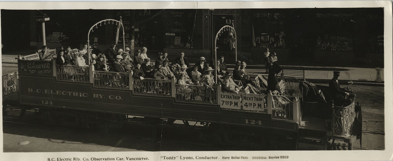
B.C. Electric Railway Co. Observation Car
https://search.heritageburnaby.ca/link/museumdescription1097
- Repository
- Burnaby Village Museum
- Date
- July 22, 1934
- Collection/Fonds
- Burnaby Village Museum Photograph collection
- Description Level
- Item
- Physical Description
- 1 photograph : b&w ; 9.5 x 23.5 cm
- Scope and Content
- Photograph of a BC Electric Railway Company Observation car, full of people and conducted by "Teddy" Lyons. The car number is 124, and a sign on the rear end of the car reads, "See Vancouver / Two Hour / Trip / Fare 35c." The photograph was probably taken prior to 4:00 pm, as there are signs hang…
- Repository
- Burnaby Village Museum
- Collection/Fonds
- Burnaby Village Museum Photograph collection
- Description Level
- Item
- Physical Description
- 1 photograph : b&w ; 9.5 x 23.5 cm
- Scope and Content
- Photograph of a BC Electric Railway Company Observation car, full of people and conducted by "Teddy" Lyons. The car number is 124, and a sign on the rear end of the car reads, "See Vancouver / Two Hour / Trip / Fare 35c." The photograph was probably taken prior to 4:00 pm, as there are signs hanging on the car by the conductor that read, "Extra Trip / 7:00 PM" and "Next Trip / 4:00 PM." There are restaurants and various stores which line the street by the tracks in the background. The caption printed on the front bottom of the photo reads, "B.C. Electric Rly. Co. Observation Car, Vancouver. / "Teddy" Lyons, Conductor. Harry Bullen Photo. 2608 Gran. Bayview 8869." Stamped on the back of the photo is "Vancouver, B.C. Jul 22 1934."
- Subjects
- Transportation - Electric Railroads
- Geographic Access
- Vancouver
- Accession Code
- HV972.142.1
- Access Restriction
- No restrictions
- Reproduction Restriction
- No known restrictions
- Date
- July 22, 1934
- Media Type
- Photograph
- Related Material
- For another photograph of BCER car # 124, but from a different year, see photograph HV973.26.143 For another photograph of BCER observation car by Harry Bullen, see HV975.88.1
- Scan Resolution
- 600
- Scan Date
- 2023-04-18
- Photographer
- Bullen, Harry Elder
- Notes
- Title based on contents of photograph
- In "History of Metropolitan Vancouver" at http://www.vancouverhistory.ca/chronology6.htm, it notes that Harry Bullen sold long narrow souvenir photographs of the passengers taken in the car
Images
![Boys' rugby team, [1931 or 1932] thumbnail](/media/Hpo/_Data/_BVM_Images/2016/2016_0046_0147_001.jpg?width=280)
Boys' rugby team
https://search.heritageburnaby.ca/link/museumdescription18969
- Repository
- Burnaby Village Museum
- Date
- [1931 or 1932]
- Collection/Fonds
- Waplington family fonds
- Description Level
- Item
- Physical Description
- 1 photograph : screened copy ; 16 x 18 cm
- Scope and Content
- Printed copy of a photograph of Vancouver Normal School boys' rugby team clipped from a page within publication "Annual 1931-1932 Provincial Normal School Vancouver, B.C." The copy is autographed with first names of rugby team members. Ray Fleming is identified seated in the front row to the right …
- Repository
- Burnaby Village Museum
- Collection/Fonds
- Waplington family fonds
- Description Level
- Item
- Physical Description
- 1 photograph : screened copy ; 16 x 18 cm
- Scope and Content
- Printed copy of a photograph of Vancouver Normal School boys' rugby team clipped from a page within publication "Annual 1931-1932 Provincial Normal School Vancouver, B.C." The copy is autographed with first names of rugby team members. Ray Fleming is identified seated in the front row to the right of the person holding the rugby ball.
- Subjects
- Sports
- Sports - Rugby
- Accession Code
- BV016.46.147
- Access Restriction
- No restrictions
- Reproduction Restriction
- No known restrictions
- Date
- [1931 or 1932]
- Media Type
- Photograph
- Scan Resolution
- 600
- Scan Date
- 13-Aug-2018
- Notes
- Title based on information contained within photograph album
- Note in pen below photograph reads: "NORMAL_SCHOOL_VANCOUVER_1931-32"
- Names of each player are signed in ink on upper torso of each
- Copy of photograph is part of Photograph album BV016.46.52 and was clipped from Annual from Provincial Normal School Vancouver 1931-32. Printed photograph on verso is of Girls' Basketball "A" Team.
Images
![Boys' rugby team, [1931 or 1932] thumbnail](/media/Hpo/_Data/_BVM_Images/2016/2016_0046_0147_001.jpg)