Narrow Results By
Subject
- Advertising Medium 6
- Advertising Medium - Business Cards 3
- Agricultural Tools and Equipment 1
- Agriculture 1
- Buildings 22
- Buildings - Civic 3
- Buildings - Civic - Art Galleries 3
- Buildings - Commercial 12
- Buildings - Commercial - Hotels and Motels 11
- Buildings - Commercial - Stores 1
- Buildings - Recreational 1
- Buildings - Recreational - Outdoor Swimming Pools 1
Creator
- British Columbia Underwriters' Association 13
- Coast Map and Blue Print Co. 1
- Dominion Map and Blueprint Co. 1
- Draper, William Nelson 1
- Hill, Albert James 1
- Hill and Barnett Land Surveyors 1
- Mahon, McFarland & Mahon 1
- Municipal Council of Burnaby 1
- Plan Department, British Columbia Insurance Underwriters' Association 8
- Smith, H. Neville 1
- Vancouver Map and Blue Print Company 1
- The Vancouver Map & Blueprint Co. Ltd. 1
Person / Organization
- British Columbia Electric Railway Company 5
- Burnaby Art Gallery 5
- Burnaby Centennial '71 Committee 1
- Burnaby Mountain Centennial Park 3
- Burnaby Village Museum 1
- Dominion Photo Company 8
- Fraser Valley Milk Producers Association 5
- George, Chief Daniel "Dan" 1
- George, Wilhelmina "Willie" 1
- Gilmore Avenue School 1
- Girl Guides of Canada 1
- Kelly Douglas and Company Limited 1
The City of Vancouver B.C.
https://search.heritageburnaby.ca/link/archivedescription66103
- Repository
- City of Burnaby Archives
- Date
- [between 1916 and 1929]
- Collection/Fonds
- Burnaby Historical Society fonds
- Description Level
- Item
- Physical Description
- 1 map : b&w ink on paper ; 56 x 107 cm folded to 21 x 12.5 cm
- Scope and Content
- Item is a map of "[the] City of Vancouver B.C" drawn prior to amalgamation of Point Grey and South Vancouver with the City of Vancouver.
- Repository
- City of Burnaby Archives
- Date
- [between 1916 and 1929]
- Collection/Fonds
- Burnaby Historical Society fonds
- Subseries
- Ephemera subseries
- Physical Description
- 1 map : b&w ink on paper ; 56 x 107 cm folded to 21 x 12.5 cm
- Material Details
- Map has a blue construction paper cover
- Scale : 1 inch = 1000 feet
- Description Level
- Item
- Record No.
- 42707
- Accession Number
- BHS2007-04
- Scope and Content
- Item is a map of "[the] City of Vancouver B.C" drawn prior to amalgamation of Point Grey and South Vancouver with the City of Vancouver.
- Media Type
- Cartographic Material
- Notes
- Transcribed title
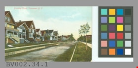
postcard
https://search.heritageburnaby.ca/link/museumartifact44517
- Repository
- Burnaby Village Museum
- Accession Code
- BV002.34.1
- Description
- Postcard: colour-tinted photo; horizontal; shows row of houses at left, road with wooden forms? either side, row of newly planted trees staked in grass at right, sidewalks; in red at top left, "Burnaby Street, Vancouver, B.C."; on reverse in red, "PRIVATE POST CARD"; up left side, "Published by Stedman Bros. Ltd., Brantford, Canada. Made in Germany."; line across card and line down centre; at left, "THIS SPACE MAY BE USED FOR CORRESPONDENCE", at right, "THIS SPACE IS FOR ADDRESS ONLY"; outline of rectangle at upper right, "1c. CANADA AND UNITED STATES." "2c. FOREIGN."; at lower left corner, "S B 2027"; unused; lightly soiled; wear on corners
- Object History
- Bought from E-Bay as purchase #1093584940.
- Classification
- Written Communication T&E - - Writing Media
- Object Term
- Postcard
- Maker
- Stedman Bros. Limited
- Country Made
- Canada
- Province Made
- Manitoba
- Site/City Made
- Brantford
- Title
- Burnaby Street, Vancouver, B.C. S B 2027
- Geographic Access
- Vancouver
Images

postcard
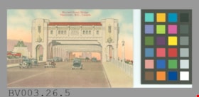
https://search.heritageburnaby.ca/link/museumartifact45453
- Repository
- Burnaby Village Museum
- Accession Code
- BV003.26.5
- Description
- Postcard: coloured illustration, horizontal; shows the Burrard Street Bridge with cars crossing it; view appears to be looking north as the Hotel Vancouver can be seen off to the left; in red at top, "Burrard Street Bridge Vancouver, B.C., Canada."; on reverse in black, "POST CARD", line down centre; at left, "Message May Be Written On This Side"; at right, "Address Only On This Side"; up left side, THE COAST PUBLISHING CO., VANCOUVER, B.C."; outline of rectangle at upper right, "PLACE STAMP HERE" "C.P. 157"; unused; discolouration, creases, some wear at corners; NOTE that although the bridge opened in 1932 the postcard appears to have been created at a later date, as the Hotel Vancouver did not open until 1939; hotel is on the east side of Burrard
- Object History
- Purchased from E-Bay, #2163154620.
- Classification
- Written Communication T&E - - Writing Media
- Object Term
- Postcard
- Maker
- Coast Publishing Company
- Country Made
- Canada
- Province Made
- British Columbia
- Site/City Made
- Vancouver
- Title
- Burrard Street Bridge Vancouver, B.C., Canada C.P. 157
- Publication Date
- [ca. 1940].
- Geographic Access
- Vancouver
Images

postcard
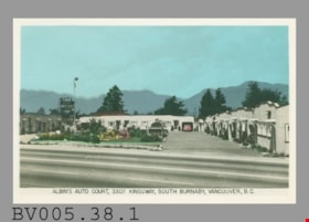
https://search.heritageburnaby.ca/link/museumartifact48601
- Repository
- Burnaby Village Museum
- Accession Code
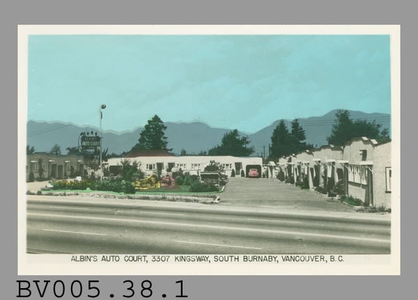
- BV005.38.1
- Description
- Postcard: tinted photo; horizontal; white border, deeper at the bottom with black print "ALBIN'S AUTO COURT, 3307 KINGSWAY, SOUTH BURNABY, VANCOUVER, B.C."; shows motel from across Kingsway, single-storey white buildings in a u-shape, built-in garages, some cars visible; grassy square, large standing neon sign with motel's name, stars on top; mountains behind show printing is slightly off; on reverse in grey, "SCENE O CHROM", 'S', 'M', and middle 'O' are larger; down centre, "MADE IN CANADA BY THE GOWEN, SUTTON CO. LTD., VANCOUVER, B.C."; at left, "MESSAGE", at right "ADDRESS"; some roughness at left edge; unused [NOTE that location is Postcard Binder 1]
- Object History
- E-Bay purchase, item #6160068130.
- Classification
- Written Communication T&E - - Writing Media
- Object Term
- Postcard
- Marks/Labels
- Albin's Auto Court, 3307 Kingsway, South Burnaby, Vancouver, B.C.
- Country Made
- Canada
- Province Made
- British Columbia
- Site/City Made
- Vancouver
- Title
- Albin's Auto Court, 3307 Kingsway, South Burnaby, Vancouver, B.C.
- Subjects
- Documentary Artifacts
- Documentary Artifacts - Postcards
- Documentary Artifacts - Photographs
- Buildings
- Buildings - Commercial
- Buildings - Commercial - Hotels and Motels
Images
postcard; advertisement
https://search.heritageburnaby.ca/link/museumartifact44818
- Repository
- Burnaby Village Museum
- Accession Code
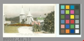
- BV002.48.10
- Description
- Postcard: coloured black and white photo, glossy; white border; horizontal; shows entrance gate of Forest Lawn cemetary, stone posts with caps and spires, chapel in background, flowers and shrubs; in black in wider bottom border, "CANADA'S MOST BEAUTIFUL CEMETARY" "FOREST LAWN MEMORIAL PARK, VANCOUVER, B.C."; in image at lower right, white "7."; on reverse in grey, "MADE IN CANADA BY THE GOWEN, SUTTON CO. LTD., VANCOUVER, B.C." "POSTCARD"; at left, "CORRESPONDENCE", at right, "ADDRESS"; slightly darkened around edges; corners are worn; unused
- Classification
- Written Communication T&E - - Writing Media
- Object Term
- Postcard
- Country Made
- Canada
- Province Made
- British Columbia
- Site/City Made
- Vancouver
- Title
- Canada's Most Beautiful Cemetary Forest Lawn Memorial Park, Vancouver, B.C. 7
Images

postcard; advertisement
https://search.heritageburnaby.ca/link/museumartifact44823
- Repository
- Burnaby Village Museum
- Accession Code
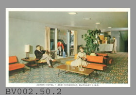
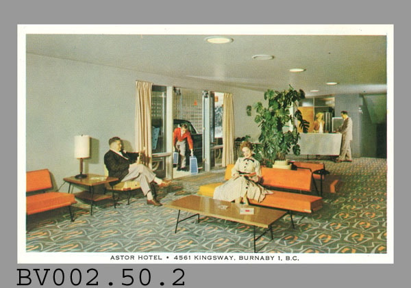
- BV002.50.2
- Description
- Postcard: colour photo; horizontal; hotel lobby; white border with black print at bottom "ASTOR HOTEL. 3985 KINGSWAY, VANCOUVER, B.C."; lobby has c. 1950s furnishings, people seated and standing; image is blurred; on reverse in black, "LOBBY" "Actual photograph of the comfortable lobby of the Astor Hotel", aboriginal animal logo, "POST CARD"; line down centre; at left, "CORRESPONDENCE", at right, "ADDRESS"; outline of rectangle at upper right with "Stamp Here"; soiled; surface tears from adhesive? contact; "4.00"? erased at upper left; some wear on corners; unused
- Classification
- Written Communication T&E - - Writing Media
- Object Term
- Postcard
- Title
- Astor Hotel . 3985 Kingsway, Vancouver, B.C.
- Subjects
- Documentary Artifacts
- Documentary Artifacts - Postcards
- Documentary Artifacts - Photographs
- Buildings
- Buildings - Commercial
- Buildings - Commercial - Hotels and Motels
Images

Municipality of Burnaby- Volume XV and Volume XVIII
https://search.heritageburnaby.ca/link/museumdescription8686
- Repository
- Burnaby Village Museum
- Date
- May 1927
- Collection/Fonds
- Burnaby Village Museum Map collection
- Description Level
- File
- Physical Description
- 4 plans on 4 sheets : col. lithographic prints ; 63.5 x 53.5 cm folded to 53 x 31.5 cm
- Scope and Content
- File consists of four pages of plans removed from a bound book containing a series of fire insurance plans of the Municipality of Burnaby. Plan "1520" is part of "GREATER VANCOUVER B.C. / VOLUME XV / Municipality of Burnaby / May 1927" and covers District Lots: 121 and 187. Plann "1521" is part of …
- Repository
- Burnaby Village Museum
- Collection/Fonds
- Burnaby Village Museum Map collection
- Description Level
- File
- Physical Description
- 4 plans on 4 sheets : col. lithographic prints ; 63.5 x 53.5 cm folded to 53 x 31.5 cm
- Material Details
- Scale [1:600] and [1:1200]
- Scope and Content
- File consists of four pages of plans removed from a bound book containing a series of fire insurance plans of the Municipality of Burnaby. Plan "1520" is part of "GREATER VANCOUVER B.C. / VOLUME XV / Municipality of Burnaby / May 1927" and covers District Lots: 121 and 187. Plann "1521" is part of "GREATER VANCOUVER B.C. / VOLUME XV / Municipality of Burnaby / May 1927" and covers District Lots: 121 and 187. Key plan "H" reads: "GREATER VANCOUVER B.C. / VOLUME XVIII / Surveyed _ May 1927 / MUNICIPALITY OF / BURNABY" and covers plans: 1813 to 1822; 1824 to 1832; 1839; 1840; 1853 to 1865 and District Lots: 28; 30; 53; 90 to 93; 95 to 97; 155a; 155b; 155c; 159; 160; 171 to 173. Plan "1801" is part of "GREATER VANCOUVER B.C. / VOLUME XVIII / Municipality of Burnaby / May 1927" and covers District Lot 153.
- Responsibility
- British Columbia Underwriters' Association
- Accession Code
- HV972.111.8
- Access Restriction
- No restrictions
- Reproduction Restriction
- May be restricted by third party rights
- Date
- May 1927
- Media Type
- Cartographic Material
- Historic Neighbourhood
- Fraser Arm (Historic Neighbourhood)
- Vancouver Heights (Historic Neighbourhood)
- East Burnaby (Historic Neighbourhood)
- Edmonds (Historic Neighbourhood)
- Planning Study Area
- Marlborough Area
- Kingsway-Beresford Area
- Windsor Area
- Big Bend Area
- Clinton-Glenwood Area
- Burnaby Heights Area
- Edmonds Area
- Stride Avenue Area
- Scan Resolution
- 400
- Scan Date
- 2021-11-18
- Notes
- Title based on content of plans
- See also BV987.1.70d for revised versions of plans
- Scale is measured 1 inch = 500 feet
Zoomable Images


Municipality of Burnaby - Volume XVI and Volume XVII
https://search.heritageburnaby.ca/link/museumdescription8684
- Repository
- Burnaby Village Museum
- Date
- May 1927
- Collection/Fonds
- Burnaby Village Museum Map collection
- Description Level
- File
- Physical Description
- 4 plans on 4 sheets : col. lithographic prints ; 63.5 x 53.5 cm folded to 53 x 31.5 cm
- Scope and Content
- File consists of four pages of plans removed from a bound book containing a series of fire insurance plans of the Municipality of Burnaby. Page "D" is titled: "GREATER VANCOUVER B.C. / VOLUME XVI / Surveyed _ May 1927 / MUNICIPALITY OF / BURNABY / PLAN DEPT. FIRE BRANCH _ B.C. INSURANCE UNDERWRITE…
- Repository
- Burnaby Village Museum
- Collection/Fonds
- Burnaby Village Museum Map collection
- Description Level
- File
- Physical Description
- 4 plans on 4 sheets : col. lithographic prints ; 63.5 x 53.5 cm folded to 53 x 31.5 cm
- Material Details
- Scale [1:1200] and [1:6000]
- Scope and Content
- File consists of four pages of plans removed from a bound book containing a series of fire insurance plans of the Municipality of Burnaby. Page "D" is titled: "GREATER VANCOUVER B.C. / VOLUME XVI / Surveyed _ May 1927 / MUNICIPALITY OF / BURNABY / PLAN DEPT. FIRE BRANCH _ B.C. INSURANCE UNDERWRITERS ASSN." / KEY PLAN". Plans covered in this "Key Plan" are numbered 1601 to 1626, 1632 and 1651 covering District Lots: 15; 31; 100 to 102; 114; 141 to 144; 147 and 148; 209 to 214. Plan "E" is part of "GREATER VANCOUVER B.C. / VOLUME XVII / Municipality of Burnaby / May 1927" and covers plans: 1701 to 1705; 1711 to 1715; 1723 to 1727; 1729 to 1733; 1737 to 1742 and District Lots: 68 to 74; 80 to 84; 32 to 35 and 38 to 39. Plan marked "F" is a key plan titled: "GREATER VANCOUVER B.C. / VOLUME XVII / Surveyed _ May 1927 / MUNICIPALITY OF / BURNABY and covers plans: 1706 to 1710; 1716 to 1722; 1734 and 1735; 1743 to 1752 and District Lots: 42 to 44; 59; 75 to 80; 83 to 87; 89 to 93 and 130. Plan "1729" is part of "GREATER VANCOUVER B.C. / VOLUME XVII / Municipality of Burnaby / May 1927" and covers District Lots 34 and 35.
- Responsibility
- British Columbia Underwriters' Association
- Accession Code
- HV972.111.6
- Access Restriction
- No restrictions
- Reproduction Restriction
- May be restricted by third party rights
- Date
- May 1927
- Media Type
- Cartographic Material
- Historic Neighbourhood
- Barnet (Historic Neighbourhood)
- Burquitlam (Historic Neighbourhood)
- Central Park (Historic Neighbourhood)
- Burnaby Lake (Historic Neighbourhood)
- Broadview (Historic Neighbourhood)
- Planning Study Area
- Burnaby Mountain Area
- Lyndhurst Area
- Lake City Area
- Cascade-Schou Area
- Garden Village Area
- Douglas-Gilpin Area
- Oakalla Area
- Scan Resolution
- 400
- Scan Date
- 2021-11-18
- Notes
- Title based on content of plans
- See also BV987.1.70d for revised versions of plans
- Scale is measured 1 inch = 500 feet
Zoomable Images


Municipality of Burnaby - Volume XV, Volume XVI, Volume XVII, Volume XVIII
https://search.heritageburnaby.ca/link/museumdescription8685
- Repository
- Burnaby Village Museum
- Date
- May 1927
- Collection/Fonds
- Burnaby Village Museum Map collection
- Description Level
- File
- Physical Description
- 4 plans on 4 sheets : col. lithographic prints ; 63.5 x 53.5 cm folded to 53 x 31.5 cm
- Scope and Content
- File consists of four pages of plans removed from a bound book containing a series of fire insurance plans of the Municipality of Burnaby. Plan "1531" is part of "GREATER VANCOUVER B.C. / VOLUME XV / Municipality of Burnaby / May 1927" and covers District Lots: 116 and 117. Key Plan "C" is part of …
- Repository
- Burnaby Village Museum
- Collection/Fonds
- Burnaby Village Museum Map collection
- Description Level
- File
- Physical Description
- 4 plans on 4 sheets : col. lithographic prints ; 63.5 x 53.5 cm folded to 53 x 31.5 cm
- Material Details
- Scale [1:600] and [1:1200]
- Scope and Content
- File consists of four pages of plans removed from a bound book containing a series of fire insurance plans of the Municipality of Burnaby. Plan "1531" is part of "GREATER VANCOUVER B.C. / VOLUME XV / Municipality of Burnaby / May 1927" and covers District Lots: 116 and 117. Key Plan "C" is part of "GREATER VANCOUVER B.C. / VOLUME XVI / Municipality of Burnaby / May 1927" and covers plans 1623 to 1651 and District Lots: 1 and 2; 4; 6; 8; 10 to 14; 25; 27; 40; 56 to 58; 88 and 89. Plan "1738" is part of "GREATER VANCOUVER B.C. / VOLUME XVII / Municipality of Burnaby / May 1927" and covers District Lots: 34 and 35. Key plan "G" is part of "GREATER VANCOUVER B.C. / VOLUME XVIII / Municipality of Burnaby / May 1927" and covers plans: 1801 to 1813; 1823; 1824; 1833 to 1838; 1841 to 1853 and District Lots: 32; 93; 94; 97 to 99; 149; 150; 152; 155 to 159; 161 to 164.
- Responsibility
- British Columbia Underwriters' Association
- Accession Code
- HV972.111.7
- Access Restriction
- No restrictions
- Reproduction Restriction
- May be restricted by third party rights
- Date
- May 1927
- Media Type
- Cartographic Material
- Historic Neighbourhood
- Central Park (Historic Neighbourhood)
- Fraser Arm (Historic Neighbourhood)
- Alta Vista (Historic Neighbourhood)
- Broadview (Historic Neighbourhood)
- Vancouver Heights (Historic Neighbourhood)
- Burquitlam (Historic Neighbourhood)
- East Burnaby (Historic Neighbourhood)
- Edmonds (Historic Neighbourhood)
- Lozells (Historic Neighbourhood)
- Planning Study Area
- Clinton-Glenwood Area
- Marlborough Area
- Maywood Area
- Windsor Area
- Big Bend Area
- Garden Village Area
- Willingdon Heights Area
- West Central Valley Area
- Cariboo-Armstrong Area
- Lyndhurst Area
- Cameron Area
- Lake City Area
- Edmonds Area
- Second Street Area
- Sperling-Broadway Area
- Lakeview-Mayfield Area
- Scan Resolution
- 400
- Scan Date
- 2021-11-18
- Notes
- Title based on content of plans
- See also BV987.1.70d for revised versions of plans
- Scale is measured 1 inch = 500 feet
Zoomable Images

Municipality of Burnaby - Volume XV, Volume XVI, Volume XVII, Volume XVIII, May 1927
Zoom into Image
postcard
https://search.heritageburnaby.ca/link/museumartifact48610
- Repository
- Burnaby Village Museum
- Accession Code
- BV005.41.4
- Description
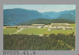
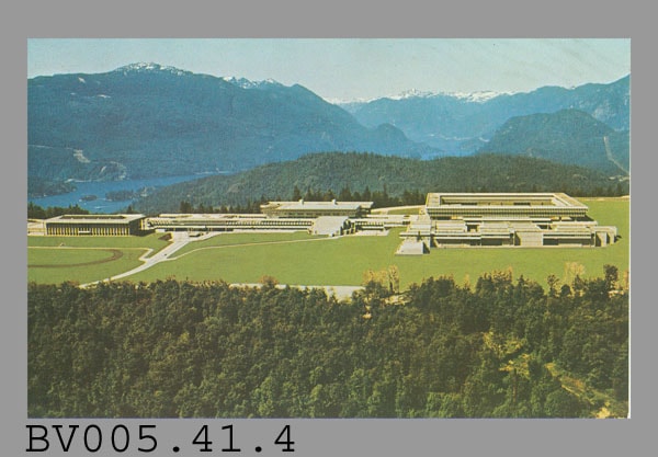
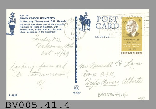
- Postcard: colour aerial photo of Simon Fraser University; horizontal; on reverse in navy, "N.W. 49" "SIMON FRASER UNIVERSITY" "N. Burnaby (Vancouver), B.C. Canada" "The aerial view shows..."; illustration of R.C.M.P. officer at left; at bottom left, "S-2587"; navy line up centre with "NATURAL COLOR PRODUCTIONS, LTD., VANCOUVER, B.C."; at bottom, "MADE IN CANADA" "GRANT-MANN", logo; at upper right, illustration of mounted R.C.M.P. officer, "POST CARD" "ADDRESS"; large beige stamp at upper right corner, "6" "VINCENT MASSEY 1887-1967" "GOVERNOR GENERAL" "GOUVERNEUR GENERAL" "1952-1959" "CANADA"; round postmark "VANCOUVER B.C." "7 -M" "OCT --" "19-9"; rectangular cancellation "HADASSAH BAZAAR" "P.N.E. SHOWMART" "PURE FOODS BLDG." "OCT.22 - --"; addressed in pencil, "Mr. Russell H. Lane" "Box 898," "High River, Alberta"; message "Tuesday P.M." "Vancouver, B.C." "Oct 14/69" "Looking forward to tomorrow! K"; slight smudging
- Classification
- Written Communication T&E - - Writing Media
- Object Term
- Postcard
- Marks/Labels
- Simon Fraser University / N. Burnaby (Vancouver), B.C. Canada
- Country Made
- Canada
- Province Made
- British Columbia
- Site/City Made
- Vancouver
- Title
- Simon Fraser University S-2587
- Publication Date
- October 14 1969
- Subjects
- Documentary Artifacts
- Documentary Artifacts - Postcards
- Documentary Artifacts - Photographs
- Buildings
- Buildings - Schools
- Buildings - Schools - Universities and Colleges
- Names
- Simon Fraser University
Images

Municipality of Burnaby - Volume XV and Volume XVIII
https://search.heritageburnaby.ca/link/museumdescription8680
- Repository
- Burnaby Village Museum
- Date
- May 1927
- Collection/Fonds
- Burnaby Village Museum Map collection
- Description Level
- File
- Physical Description
- 4 plans on 4 sheets : col. lithographic prints ; 63.5 x 53.5 cm folded to 53 x 31.5 cm
- Scope and Content
- File consists of four pages of plans removed from a bound book containing a series of fire insurance plans of the Municipality of Burnaby. The first two pages are numbered "A" and "B" and are key plans from "GREATER VANCOUVER B.C. / VOLUME XV / Surveyed _ May 1927 / MUNICIPALITY OF / BURNABY", "PLA…
- Repository
- Burnaby Village Museum
- Collection/Fonds
- Burnaby Village Museum Map collection
- Description Level
- File
- Physical Description
- 4 plans on 4 sheets : col. lithographic prints ; 63.5 x 53.5 cm folded to 53 x 31.5 cm
- Material Details
- Scales [1:1200] and [1:6000]
- Scope and Content
- File consists of four pages of plans removed from a bound book containing a series of fire insurance plans of the Municipality of Burnaby. The first two pages are numbered "A" and "B" and are key plans from "GREATER VANCOUVER B.C. / VOLUME XV / Surveyed _ May 1927 / MUNICIPALITY OF / BURNABY", "PLAN DEPT. FIRE BRANCH _ B.C. INSURANCE UNDERWRITERS ASSN.". Key Plan "B" covers plans: 1505; 1506; 1512 to 1516; 1540 to 1544; 1550 to 1557 and District Lots: 129 to 132; 135 to 138; 205 to 208 and 215 to 218. Key Plan "A" covers plans: 1501 to 1504; 1507 to 1511; 1517 to 1525; 1531 to 1539; 1545 to 1550 and District Lots: 116 to 127 and 186 to 189. Plan "1806" is part of "GREATER VANCOUVER B.C. / VOLUME XVIII / Municipality of Burnaby / May, 1927" and covers District Lot 153. Plan "1807" is from "GREATER VANCOUVER B.C. / VOLUME XVIII / Municipality of Burnaby / May, 1927" and covers District Lots: 99,149 and 152.
- Responsibility
- British Columbia Underwriters' Association
- Accession Code
- HV972.111.2
- Access Restriction
- No restrictions
- Reproduction Restriction
- May be restricted by third party rights
- Date
- May 1927
- Media Type
- Cartographic Material
- Historic Neighbourhood
- Vancouver Heights (Historic Neighbourhood)
- Lochdale (Historic Neighbourhood)
- Capitol Hill (Historic Neighbourhood)
- Central Park (Historic Neighbourhood)
- Alta Vista (Historic Neighbourhood)
- Planning Study Area
- Burnaby Heights Area
- Sperling-Broadway Area
- Lochdale Area
- Parkcrest-Aubrey Area
- Westridge Area
- Willingdon Heights Area
- Capitol Hill Area
- Maywood Area
- Marlborough Area
- Scan Resolution
- 400
- Scan Date
- 2021-11-18
- Notes
- Title based on content of plans
- Scales are measured 1 inch = 100 feet and 1 inch = 500 feet
- See also BV987.1.70d for revised versions of plans
Zoomable Images


postcard
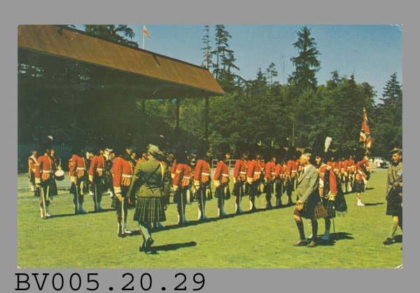
https://search.heritageburnaby.ca/link/museumartifact48386
- Repository
- Burnaby Village Museum
- Accession Code
- BV005.20.29
- Description
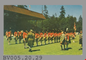
- Postcard: colour photo, glossy; horizontal; grassy field with rows of people in Scottish regimental dress, red jackets, being inspected by people in green jackets; part of covered bleachers visible at left, trees behind (Central Park in Burnaby?); on reverse in brown, "V-32 CALEDONIAN GAMES, Vancouver, B.C. (Canada)" "Inspection of a Scottish Highland Regiment... Games are held annually..."; at centre, "POST CARD"; above this, "COLOR PHOTO--COURTESY GRAY LINE SIGHTSEEING TOURS"; line down centre; up left side, "PUB. BY VANCOUVER MAGAZINE SERV. LTD., VANCOUVER, B.C,."; at bottom left, "PRINTED IN U.S.A."; at right, "Address Only On This Side"; addressed in blue pen to "Miss Louise Hodgson RR#I Ruskin B.C."; message "Friday Aug 6/54" "Dear Louise & Mum, Here I am once again just thought I would send a card just in case. These are Seaforths & the Big man with his back showing is Hoffmiester. Cass had no word about his car yet. I should I hope get nearly all the puttying done on the last side of the House today. I better go for now all my love Ever Daddy", ring of 'x's around 'Daddy'; up left side, "I will miss youse"; blue Queen Elizabeth II stamp at upper right, "E II R" "5c" "CANADA" "POSTES" "POSTAGE"; postmark "VANCOUVER B.C. CANADA" "AUG 6" "2 PM" "1954"; rectangular cancellation “BRITISH EMPIRE GAMES" "VANCOUVER-CANADA" "30 JULY - 7 AUGUST 1954"; lightly soiled, corners worn; pencilled "B530-1.75" at top
- Classification
- Written Communication T&E - - Writing Media
- Object Term
- Postcard
- Marks/Labels
- Vancouver B.C. / Aug. 6 / 2PM / 1954 / Canada / British Empire Games / Vancouver - Canada / 30 July - 7 August 1954 / Seaforths / Hoffmeister
- Title
- Caledonian Games V-32
- Publication Date
- August 6 1954
- Subjects
- Documentary Artifacts
- Documentary Artifacts - Postcards
- Documentary Artifacts - Photographs
Images

Municipality of Burnaby - Volume XV and Volume XVIII
https://search.heritageburnaby.ca/link/museumdescription8681
- Repository
- Burnaby Village Museum
- Date
- May 1927
- Collection/Fonds
- Burnaby Village Museum Map collection
- Description Level
- File
- Physical Description
- 4 plans on 4 sheets : col. lithographic prints, ms. annotations in blue ink ; 63.5 x 53.5 cm folded to 53 x 31.5 cm
- Scope and Content
- File consists of four pages of plans removed from a bound book containing a series of fire insurance plans of the Municipality of Burnaby. Plan "1507" and plan "1517" are from "GREATER VANCOUVER B.C. / VOLUME XV / Municipality of Burnaby / May, 1927". Plan "1507" covers District Lot 186 and plan "1…
- Repository
- Burnaby Village Museum
- Collection/Fonds
- Burnaby Village Museum Map collection
- Description Level
- File
- Physical Description
- 4 plans on 4 sheets : col. lithographic prints, ms. annotations in blue ink ; 63.5 x 53.5 cm folded to 53 x 31.5 cm
- Material Details
- Scale [1:600] and [1:1200]
- Scope and Content
- File consists of four pages of plans removed from a bound book containing a series of fire insurance plans of the Municipality of Burnaby. Plan "1507" and plan "1517" are from "GREATER VANCOUVER B.C. / VOLUME XV / Municipality of Burnaby / May, 1927". Plan "1507" covers District Lot 186 and plan "1517" covers District Lot 116. Plan "1804" and plan "1805" are from "GREATER VANCOUVER B.C. / VOLUME XVIII / Municipality of Burnaby / May, 1927". Plans "1804" and "1805" cover District Lot 153.
- Responsibility
- British Columbia Underwriters' Association
- Accession Code
- HV972.111.3
- Access Restriction
- No restrictions
- Reproduction Restriction
- May be restricted by third party rights
- Date
- May 1927
- Media Type
- Cartographic Material
- Historic Neighbourhood
- Central Park (Historic Neighbourhood)
- Vancouver Heights (Historic Neighbourhood)
- Planning Study Area
- Maywood Area
- Willingdon Heights Area
- Scan Resolution
- 400
- Scan Date
- 2021-11-18
- Notes
- Title based on content of plans
- See also BV987.1.70d for revised versions of plans
- Scale is measured 1 inch = 100 feet
Images


![Municipality of Burnaby - Volume XV and Volume XVIII, 1927-[1940] thumbnail](/media/hpo/_Data/_BVM_Artifacts/1972/1972_0111_0004_003.jpg?width=280)
Municipality of Burnaby - Volume XV and Volume XVIII
https://search.heritageburnaby.ca/link/museumdescription8682
- Repository
- Burnaby Village Museum
- Date
- 1927-[1940]
- Collection/Fonds
- Burnaby Village Museum Map collection
- Description Level
- File
- Physical Description
- 4 plans on 4 sheets: col. lithographic prints ; 63.5 x 53.5 cm folded to 53 x 31.5 cm
- Scope and Content
- File consists of four pages of plans removed from a bound book containing a series of fire insurance plans of the Municipality of Burnaby. Plan "1518" and "1519" are from "GREATER VANCOUVER B.C. / VOLUME XV / Municipality of Burnaby / May, 1927". Plan "1518" covers District Lot 116 and Plan "1519"…
- Repository
- Burnaby Village Museum
- Collection/Fonds
- Burnaby Village Museum Map collection
- Description Level
- File
- Physical Description
- 4 plans on 4 sheets: col. lithographic prints ; 63.5 x 53.5 cm folded to 53 x 31.5 cm
- Material Details
- Scale [1:600]
- Scope and Content
- File consists of four pages of plans removed from a bound book containing a series of fire insurance plans of the Municipality of Burnaby. Plan "1518" and "1519" are from "GREATER VANCOUVER B.C. / VOLUME XV / Municipality of Burnaby / May, 1927". Plan "1518" covers District Lot 116 and Plan "1519" covers District Lot 121. Plan "1802" and plan "1803" are from "GREATER VANCOUVER B.C. / VOLUME XVIII / Municipality of Burnaby / May, 1927". Both plans "1802" and "1803" cover District Lot 153.
- Responsibility
- British Columbia Underwriters' Association
- Accession Code
- HV972.111.4
- Access Restriction
- No restrictions
- Reproduction Restriction
- May be restricted by third party rights
- Date
- 1927-[1940]
- Media Type
- Cartographic Material
- Historic Neighbourhood
- Vancouver Heights (Historic Neighbourhood)
- Central Park (Historic Neighbourhood)
- Planning Study Area
- Willingdon Heights Area
- Marlborough Area
- Scan Resolution
- 400
- Scan Date
- 2021-11-18
- Notes
- Title based on content of plans
- See also BV987.1.70d for revised versions of plans
- Scale is measured 1 inch = 50 feet
- Contact Burnaby Village Museum to access plans 1518 and 1519 (these plans have revisions on top - date of revisions is uncertain)
Images
![Municipality of Burnaby - Volume XV and Volume XVIII, 1927-[1940] thumbnail](/media/hpo/_Data/_BVM_Artifacts/1972/1972_0111_0004_003.jpg)


Municipality of Burnaby - Volume XVIII and Volume XIX
https://search.heritageburnaby.ca/link/museumdescription8683
- Repository
- Burnaby Village Museum
- Date
- May 1927
- Collection/Fonds
- Burnaby Village Museum Map collection
- Description Level
- File
- Physical Description
- 2 plans on 2 sheets : col. lithographic prints ; 63.5 x 53.5 cm folded to 53 x 31.5 cm
- Scope and Content
- File consists of two pages of plans removed from a bound book containing a series of fire insurance plans of the Municipality of Burnaby. Plan "1832" is from "GREATER VANCOUVER B.C. / VOLUME XVIII / Municipality of Burnaby / May, 1927" and covers District Lots: 98 and 28. Plan "K" is part of a key …
- Repository
- Burnaby Village Museum
- Collection/Fonds
- Burnaby Village Museum Map collection
- Description Level
- File
- Physical Description
- 2 plans on 2 sheets : col. lithographic prints ; 63.5 x 53.5 cm folded to 53 x 31.5 cm
- Material Details
- Scale [1:1200] to [1:6000]
- Scope and Content
- File consists of two pages of plans removed from a bound book containing a series of fire insurance plans of the Municipality of Burnaby. Plan "1832" is from "GREATER VANCOUVER B.C. / VOLUME XVIII / Municipality of Burnaby / May, 1927" and covers District Lots: 98 and 28. Plan "K" is part of a key plan "GREATER VANCOUVER B.C. / Surveyed VOLUME XIX May 1927 / MUNICIPALITY OF / BURNABY / PLAN DEPT. British Columbia Ins. Underwriters Association / FIRE BRANCH / KEY PLAN", "Scale 500 FT = 1 INCH / FOR REPORT SEE VOL. XV" covering plans: 1901 to 1914 and District Lots: 161; 164 to 167; 155c; 155; 172 and 173.
- Responsibility
- British Columbia Underwriters' Association
- Accession Code
- HV972.111.5
- Access Restriction
- No restrictions
- Reproduction Restriction
- May be restricted by third party rights
- Date
- May 1927
- Media Type
- Cartographic Material
- Historic Neighbourhood
- East Burnaby (Historic Neighbourhood)
- Central Park (Historic Neighbourhood)
- Fraser Arm (Historic Neighbourhood)
- Alta Vista (Historic Neighbourhood)
- Planning Study Area
- Windsor Area
- Marlborough Area
- Second Street Area
- Big Bend Area
- Sussex-Nelson Area
- Scan Resolution
- 400
- Scan Date
- 2021-11-18
- Notes
- Title based on content of plans
- See also BV987.1.70d for revised versions of plans
- Scale is measured 1 inch = 500 feet
Zoomable Images

postcard
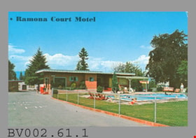
https://search.heritageburnaby.ca/link/museumartifact45028
- Repository
- Burnaby Village Museum
- Accession Code
- BV002.61.1
- Description
- Postcard: colour photo, glossy; horizontal; single-storey flat-roofed building "OFFICE" and pool surrounded by grass, chain-link fence; people in and around pool; drive in foreground, "5 MP IN -OURT", bungalow behind; on reverse in green, "RAMONA COURT" "Highway 99 and 1" "5441 Kingsway, South Burnaby," "Vancouver, B.C. Canada"; promotional copy, ends "...HEATED SWIMMING POOL" "Props. Mr. & Mrs. R.A. Gillis" "Phone He 3-9139"; at bottom left "Color Photo by John Smith" "Printed in U.S.A.", "K" logo; up centre is "Natural Color Productions Ltd., 1490 Frances St., Vancouver, B.C., Canada"; at bottom, "91533"; at upper right, "POST CARD" "Address"; blue stamp at upper right corner, Queen Elizabeth II and harbour, "POSTES" "POSTAGE" "5" "CANADA"; addressed in blue pen to"Coneour" "Gylaine et Jean" "C P 7. 000" "Teb 7" ? "Sherbrooke"; message "M-- Philippe Gagnon" "571- 5 Ave" ? "Grand Mere" "C P 173"; postmark "GRAND MERE QUEBEC" "9 PM" "23 III 1970"; stamp is cancelled with seven wavy black lines; pencilled "1.00" above cancel; small stain above stamp; some wear on corners
- Classification
- Written Communication T&E - - Writing Media
- Object Term
- Postcard
- Country Made
- Canada
- Province Made
- British Columbia
- Site/City Made
- Vancouver
- Title
- Ramona Court 91533
- Publication Date
- March 23 1970
- Subjects
- Documentary Artifacts
- Documentary Artifacts - Postcards
- Documentary Artifacts - Photographs
- Buildings
- Buildings - Commercial
- Buildings - Commercial - Hotels and Motels
Images


postcard
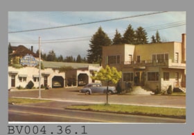
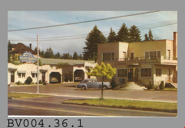
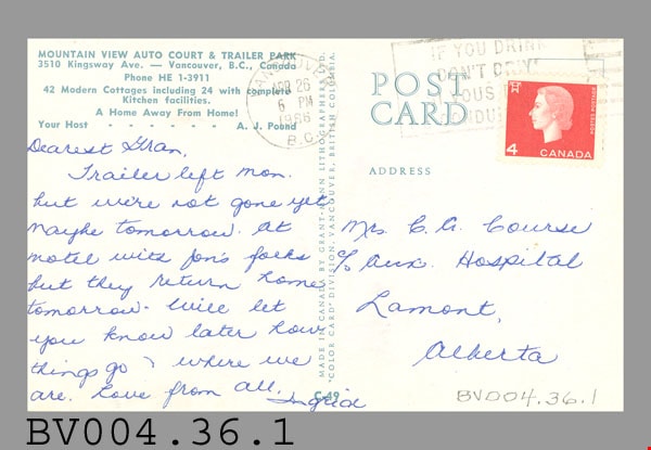
https://search.heritageburnaby.ca/link/museumartifact47142
- Repository
- Burnaby Village Museum
- Accession Code
- BV004.36.1
- Description
- Postcard: colour photo, glossy; horizontal; two-storey tan stucco building "OFFICE", with balcony, round steps, people on steps, car, drive, row of single-storey white bungalows behind at left, with crenellated fronts; blue sign with yellow lettering "MOTEL AUTO COURT", white "MOUNTAIN VIEW" above, top of sign shaped like peaks, "STEAM HEAT"? below; on reverse in green "MOUNTAIN VIEW AUTO COURT & TRAILER PARK" "3510 Kingsway Ave. -- Vancouver, B.C., Canada" "Phone HE 1-3911" "42 Modern Cottages.." "...Your Host - - - A.J. Pound"; up centre, MADE IN CANADA BY GRANT-MANN LITHOGRAPHERS LTD. "COLOR CARD" DIVISION, VANCOUVER, BRITISH COLUMBIA."; at bottom "C-49"; at upper right, "POST CARD" "ADDRESS"; red Queen Elizabeth II stamp "4" "CANADA" "POSTES POSTAGE" and powerline support pole symbol?; addressed in blue pen to "Mrs. C.A. Course" "c/o Aux. Hospital" "Lamont, Alberta"; postmarked "VANCOUVER B.C." "APR 26" "6 PM" "1966"; stamp is cancelled with black "IF YOU DRINK DON'T DRIVE" "SI VOUS -- NE CONDUI---"; message "Dearest Gran, Trailer left Mon. but we're not gone yet maybe tomorrow. At motel with Jon's folks but they return home tomorrow. Will let you know later how things go where we are. Love from All. Ingrid"; lightly soiled, wear on corners
- Classification
- Written Communication T&E - - Writing Media
- Object Term
- Postcard
- Marks/Labels
- Mountain View Auto Court & Trailer Park / 3510 Kingsway Ave. / Vancouver, B.C., Canada / Mrs. C.A. Course
- Country Made
- Canada
- Province Made
- British Columbia
- Site/City Made
- Vancouver
- Title
- Mountain View Auto Court & Trailer Park C-49
- Publication Date
- April 26 1966
- Subjects
- Documentary Artifacts
- Documentary Artifacts - Postcards
- Documentary Artifacts - Photographs
- Buildings
- Buildings - Commercial
- Buildings - Commercial - Hotels and Motels
Images
postcard
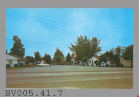
https://search.heritageburnaby.ca/link/museumartifact48613
- Repository
- Burnaby Village Museum
- Accession Code
- BV005.41.7
- Description
- Postcard: colour photo, glossy; horizontal; shows view across Hastings Street to wide drive with car, white single-storey bungalows either side, red lawn furniture, man with suitcase; red neon sign at street, angle is too sharp to read; white standing sign at right with "RAINBOW AUTO LODGE" and smaller print; on reverse in navy, "RAINBOW AUTO LODGE" "5958 E. Hastings St., Vancouver, B.C. Canada" "24 Kitchenette units..." "Telephone CYpress 8-1828 or CYpress 8-9036"; illustration at left of R.C.M.P. officer; at bottom left, "Rolly Ford Photo" "C-1039"; on navy bar up centre, "PUB. BY NATURAL COLOR PRODUCTIONS, LTD., VANCOUVER, B.C."; at bottom, "MADE IN CANADA" "GRANT-MANN", logo of man, "LITHOGRAPHY" "PHOTOGRAPHY" "DESIGN"; at upper right, illustration of mounted R.C.M.P. officer, "POST CARD" "ADDRESS", outline of rectangle, "STAMP"; unused; faint stain on reverse; on front, stain and spots; slight wear on corners; c. 1960s
- Classification
- Written Communication T&E - - Writing Media
- Object Term
- Postcard
- Marks/Labels
- Rainbow Auto Lodge / 5958 E. Hastings St., Vancouver, B.C. Canada
- Country Made
- Canada
- Province Made
- British Columbia
- Site/City Made
- Vancouver
- Title
- Rainbow Auto Lodge C-1039
- Subjects
- Documentary Artifacts
- Documentary Artifacts - Postcards
- Documentary Artifacts - Photographs
- Buildings
- Buildings - Commercial
- Buildings - Commercial - Hotels and Motels
Images

postcard; advertisement
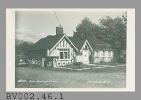
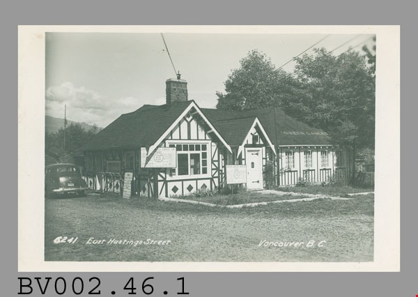
https://search.heritageburnaby.ca/link/museumartifact44794
- Repository
- Burnaby Village Museum
- Accession Code
- BV002.46.1
- Description
- Postcard, black and white photo of "Green Gables" drive-in restaurant, half-timbered house; horizontal; white border, wider at sides; on photo at bottom left, "6241 East Hastings Street"; at right, "Vancouver, B.C."; "GREEN GABLES" is on roof; three large menu boards at left, car at extreme left; undated, but probably c. 1940s; on reverse in grey "MADE IN CANADA BY THE GOWEN. SUTTON CO. LTD.. VANCOUVER. B.C." "POSTCARD"; then at left below, "CORRESPONDENCE"; and at right, "ADDRESS"; unused; lightly soiled, creased corner
- Classification
- Written Communication T&E - - Writing Media
- Object Term
- Postcard
- Colour
- Black
- White
- Country Made
- Canada
- Province Made
- British Columbia
- Site/City Made
- Vancouver
- Title
- Green Gables Drive-In
- Subjects
- Souvenirs
- Geographic Access
- Vancouver
Images
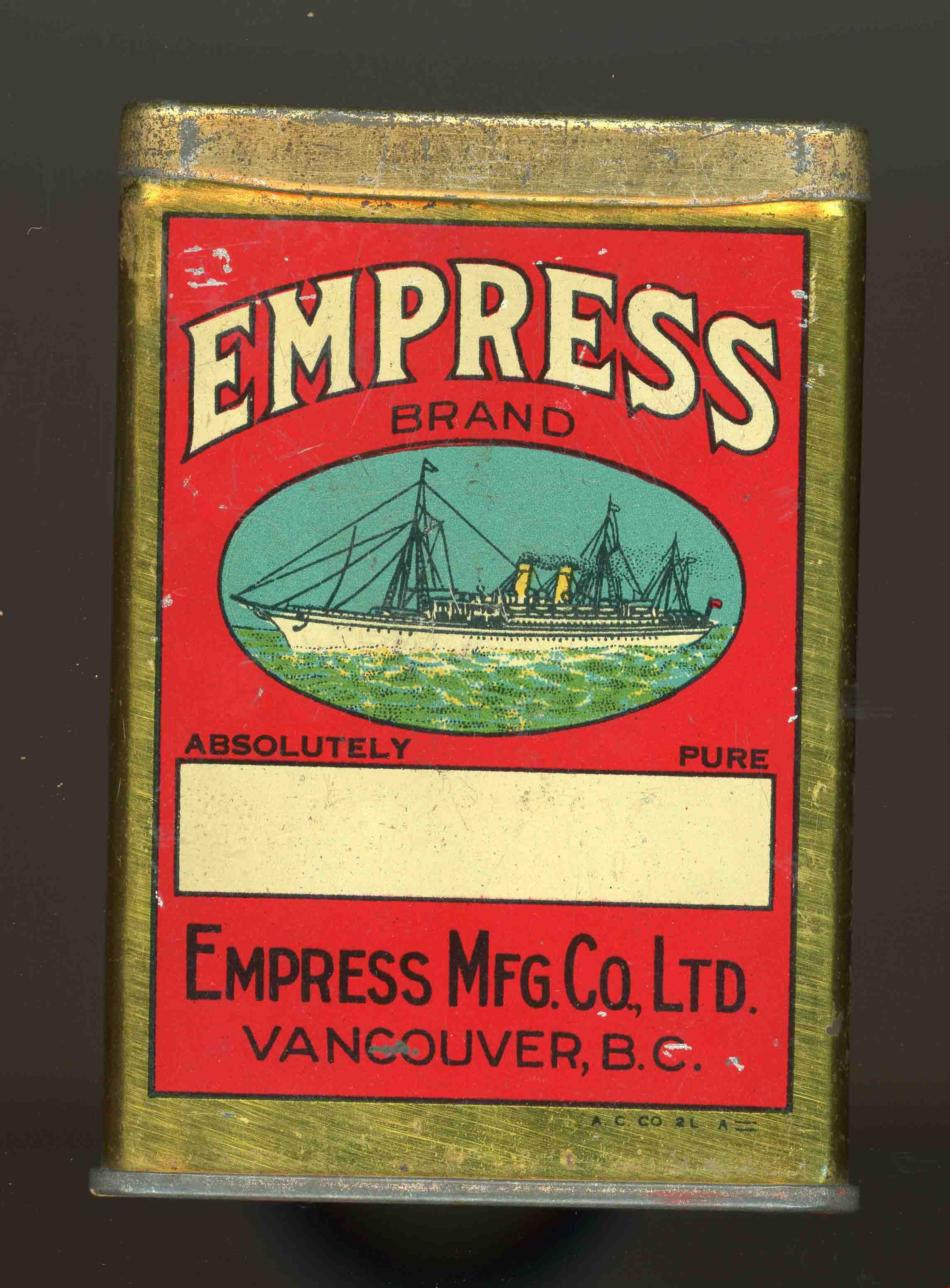
spice tin
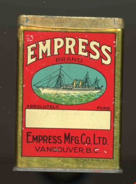
https://search.heritageburnaby.ca/link/museumartifact16709
- Repository
- Burnaby Village Museum
- Accession Code
- HV980.2.1
- Description
- Box, metal, red and gold; small; front and back are same, red with white "EMPRESS", black "BRAND", then oval picture of ship, then black "ABSOLUTELY PURE", then white rectangle with gold "CARAWAY", then black "EMPRESS MFG. CO., LTD. VANCOUVER, B.C."; on one side in black on red "1 1/2 OZ. NET"; on other side in black on red, "'MONEY BACK'--IF YOU DON'T LIKE THE CONTENTS... PROTECTED BY THE SAME DEALING" "EMPRESS MANUFACTURING CO. VANCOUVER, B.C."; top of box is gold, with sliding panel for contents to be shaken out of larger hole at one side or several smaller holes at other end; "A.C.Co.2LA"
- Measurements
- 61mm X 83mm X 28mm
Images