Narrow Results By
Decade
- 2020s 84
- 2010s 212
- 2000s 391
- 1990s 563
- 1980s 550
- 1970s 707
- 1960s 562
- 1950s 589
- 1940s 567
- 1930s 795
- 1920s
- 1910s 633
- 1900s 302
- 1890s 164
- 1880s 25
- 1870s 13
- 1860s 14
- 1850s 7
- 1840s 3
- 1830s 2
- 1820s 2
- 1810s 2
- 1800s 2
- 1790s 1
- 1780s 1
- 1770s 1
- 1760s 1
- 1750s 1
- 1740s 1
- 1730s 1
- 1720s 1
- 1710s 1
- 1700s 1
- 1690s 1
- 1680s 1
- 1670s 1
- 1660s 1
- 1650s 1
- 1640s 1
- 1630s 1
- 1620s 1
- 1610s 1
- 1600s 1
Creator
- Alphonse J. Toebaert 1
- Aston, Benjamin Gwilliam 1
- Atkinson, Dorothy Mallett 1
- Baden-Powell of Gilwell, Robert Stephenson Smyth Baden-Powell, Baron, 1857-1941 1
- Baker, Edna Dean, 1883-1956 1
- Bancroft, Rose 1
- Bateman, Caroline Mary Wettenhall 1
- Beatty Bros Limited 1
- Bellhouse, C. 1
- Betts, George Herbert, 1868-1934 1
- Bingham, Alfred "Alf" 4
- Blake, Frederick "Fred" 1
Vancouver Heights Neighbourhood
https://search.heritageburnaby.ca/link/landmark666
- Repository
- Burnaby Heritage Planning
- Associated Dates
- 1925-1954
- Heritage Value
- Vancouver Heights remained an important residential and commercial centre in Burnaby throughout the 1925-1954 period. The area had its own Board of Trade and the North Burnaby Library was created to serve the residents. In 1949, the Hastings streetcars stopped running, but the area retained its reputation as one of the best shopping districts in the city.
- Historic Neighbourhood
- Vancouver Heights (Historic Neighbourhood)
- Planning Study Area
- Burnaby Heights Area
Images
Vancouver Heights Neighbourhood
https://search.heritageburnaby.ca/link/landmark741
- Repository
- Burnaby Heritage Planning
- Associated Dates
- 1905-1924
- Heritage Value
- On December 13, 1912, The British Columbian Weekly described the Vancouver Heights neighbourhood as follows: "The northern portion of the municipality in the vicinity of Boundary Road has during the past three years made tremendous strides towards settlement. At that time Mr. James Herd and Mr. Peters were the only residents of the district...Soon, however, the timber was removed, streets laid out and other conveniences such as water, light and transportation provided... The school population of the district has increased so rapidly that the school has been enlarged twice this year and is at the present time inadequate. About 200 children are attending now. There are three churches in the district and one mission...At present time there are two large blocks containing six stores..."
- Historic Neighbourhood
- Vancouver Heights (Historic Neighbourhood)
- Planning Study Area
- Burnaby Heights Area
Images
Vancouver Heights United Church
https://search.heritageburnaby.ca/link/landmark648
- Repository
- Burnaby Heritage Planning
- Description
- Church building.
- Associated Dates
- 1926
- Street View URL
- Google Maps Street View
- Repository
- Burnaby Heritage Planning
- Geographic Access
- Ingleton Avenue
- Associated Dates
- 1926
- Description
- Church building.
- Heritage Value
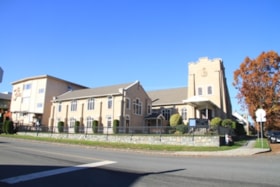
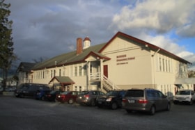
- This building was originally built in 1926 as the Vancouver Heights United Church; a Sunday School was added in 1931, which conformed to the church building’s Romanesque influenced style. This unique Burnaby building has retained its remarkable three-storey tower with buttresses and stepped parapet. It now houses the New Apostolic Church.
- Locality
- Vancouver Heights
- Historic Neighbourhood
- Vancouver Heights (Historic Neighbourhood)
- Planning Study Area
- Burnaby Heights Area
- Area
- 1133.42
- Contributing Resource
- Building
- Ownership
- Private
- Street Address
- 271 Ingleton Avenue
- Street View URL
- Google Maps Street View
Images
Conference with Vancouver City Authorities re Proposed Greater Vancouver Water Commission
https://search.heritageburnaby.ca/link/councilreport68593
- Repository
- City of Burnaby Archives
- Report ID
- 73165
- Meeting Date
- 11-Nov-1924
- Format
- Council - Mayor/Councillor/Staff Report
- Collection/Fonds
- City Council and Office of the City Clerk fonds
- Repository
- City of Burnaby Archives
- Report ID
- 73165
- Meeting Date
- 11-Nov-1924
- Format
- Council - Mayor/Councillor/Staff Report
- Collection/Fonds
- City Council and Office of the City Clerk fonds
Documents
Fires re Lists of Attendances Made by the Fire Departments of New Westminster, Vancouver and South Vancouver
https://search.heritageburnaby.ca/link/councilreport68931
- Repository
- City of Burnaby Archives
- Report ID
- 59870
- Meeting Date
- 31-Jul-1922
- Format
- Council - Mayor/Councillor/Staff Report
- Collection/Fonds
- City Council and Office of the City Clerk fonds
- Repository
- City of Burnaby Archives
- Report ID
- 59870
- Meeting Date
- 31-Jul-1922
- Format
- Council - Mayor/Councillor/Staff Report
- Collection/Fonds
- City Council and Office of the City Clerk fonds
Documents
Reference to the Joint Conference at the Vancouver City Hall re Proposed Water Commission for Greater Vancouver
https://search.heritageburnaby.ca/link/councilreport68968
- Repository
- City of Burnaby Archives
- Report ID
- 60007
- Meeting Date
- 14-Aug-1922
- Format
- Council - Mayor/Councillor/Staff Report
- Collection/Fonds
- City Council and Office of the City Clerk fonds
- Repository
- City of Burnaby Archives
- Report ID
- 60007
- Meeting Date
- 14-Aug-1922
- Format
- Council - Mayor/Councillor/Staff Report
- Collection/Fonds
- City Council and Office of the City Clerk fonds
Documents
Summary of Meeting with South Vancouver Point Grey re Value of Assets Proposed to be Taken Over by the Greater Vancouver Water District Act
https://search.heritageburnaby.ca/link/councilreport70087
- Repository
- City of Burnaby Archives
- Report ID
- 75055
- Meeting Date
- 28-Sep-1925
- Format
- Council - Mayor/Councillor/Staff Report
- Collection/Fonds
- City Council and Office of the City Clerk fonds
- Repository
- City of Burnaby Archives
- Report ID
- 75055
- Meeting Date
- 28-Sep-1925
- Format
- Council - Mayor/Councillor/Staff Report
- Collection/Fonds
- City Council and Office of the City Clerk fonds
Documents
Crabtown
https://search.heritageburnaby.ca/link/landmark674
- Repository
- Burnaby Heritage Planning
- Associated Dates
- 1912-1957
- Heritage Value
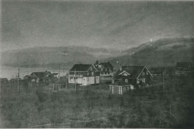
- North Burnaby's waterfront was the location of a unique squatter's community known as Crabtown. Although its origins are obscure, it is believed that the first shacks were built before 1912. When the depression of 1913-1917 began, the shacks became permanent homes for impoverished workers. During the Great Depression of the 1930s, the community grew larger. Crabtown was not a slum, but a neighbourhood - the community even rallied together to build a water supply system and trails up the steep bluff with steps and banisters so children could go to school safely. In 1957, the National Harbours Board decided that Crabtown was encroaching on Federal property and evicted all 130 residents. Within a few months, residents were relocated and 114 homes were levelled.
- Historic Neighbourhood
- Vancouver Heights (Historic Neighbourhood)
- Planning Study Area
- Burnaby Heights Area
Images
François & Cezarie Comeau Residence
https://search.heritageburnaby.ca/link/landmark580
- Repository
- Burnaby Heritage Planning
- Description
- Residential building.
- Associated Dates
- c.1925
- Street View URL
- Google Maps Street View
- Repository
- Burnaby Heritage Planning
- Geographic Access
- Esmond Avenue
- Associated Dates
- c.1925
- Description
- Residential building.
- Heritage Value
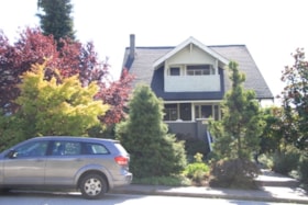
- This home was built for Francois Xavier “Frank” Comeau (1863-1943), a blacksmith who moved from Quebec to Vancouver in about 1890, and his wife Cezarie Marie (née Fortin, 1860-1950), also from Quebec, whom he married in 1903. Featuring a front gabled roof with decorative triangular eave brackets, this comfortable Craftsman bungalow displays other characteristics typical of the style such as lapped siding at the foundation, a shingle-clad main floor, casement windows and stained glass transoms on the front elevation. The most notable feature of the plan is the inset verandah with subtle segmental-arched openings and tapered square columns.
- Locality
- Vancouver Heights
- Historic Neighbourhood
- Vancouver Heights (Historic Neighbourhood)
- Planning Study Area
- Burnaby Heights Area
- Area
- 566.71
- Contributing Resource
- Building
- Ownership
- Private
- Street Address
- 306 Esmond Avenue
- Street View URL
- Google Maps Street View
Images
George & Rose Nuttall Residence
https://search.heritageburnaby.ca/link/landmark585
- Repository
- Burnaby Heritage Planning
- Description
- Residential building.
- Associated Dates
- 1921
- Other Names
- HILLCREST
- Street View URL
- Google Maps Street View
- Repository
- Burnaby Heritage Planning
- Other Names
- HILLCREST
- Geographic Access
- McGill Street
- Associated Dates
- 1921
- Description
- Residential building.
- Heritage Value
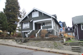
- This house was built for local plumber contractor George Nuttall (1883-1970) and his wife Rose Ann Nuttall (née Clagg, 1881-1955). George continued to live in the house after Rose’s death, until his own death in 1970. Although typical of the Craftsman style and form with its side-gabled roof, triangular eave brackets and front gabled dormer, this house has a number of special details, such as its beautiful art glass transom windows. The front verandah supports are massive stucco columns that contain stained glass lanterns with the house name, Hillcrest, and address.
- Locality
- Vancouver Heights
- Historic Neighbourhood
- Vancouver Heights (Historic Neighbourhood)
- Planning Study Area
- Burnaby Heights Area
- Area
- 566.71
- Contributing Resource
- Building
- Ownership
- Private
- Street Address
- 3756 McGill Street
- Street View URL
- Google Maps Street View
Images
John & Jessie MacLean Residence
https://search.heritageburnaby.ca/link/landmark608
- Repository
- Burnaby Heritage Planning
- Description
- Residential building.
- Associated Dates
- c.1926
- Street View URL
- Google Maps Street View
- Repository
- Burnaby Heritage Planning
- Geographic Access
- Pandora Street
- Associated Dates
- c.1926
- Description
- Residential building.
- Heritage Value
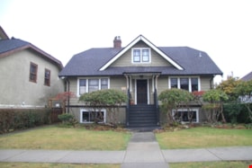
- This cottage illustrates the traditionalism of the interwar years, when domestic ideals were expressed through modest homes displaying period revival influences. Reflecting the influence of the British Arts and Crafts movement, it features a symmetrical plan, a side jerkin-headed roof, a gabled front dormer and twin-coursed shingle siding, and retains its original wooden-sash windows with unusual multi-paned upper sash. It was built for John R. and Jessie MacLean. The house was recently restored by the owners.
- Locality
- Vancouver Heights
- Historic Neighbourhood
- Vancouver Heights (Historic Neighbourhood)
- Planning Study Area
- Burnaby Heights Area
- Area
- 566.71
- Contributing Resource
- Building
- Ownership
- Private
- Street Address
- 3827 Pandora Street
- Street View URL
- Google Maps Street View
Images
Kitchener Elementary School
https://search.heritageburnaby.ca/link/landmark614
- Repository
- Burnaby Heritage Planning
- Description
- School building.
- Associated Dates
- 1925
- Street View URL
- Google Maps Street View
- Repository
- Burnaby Heritage Planning
- Geographic Access
- Gilmore Avenue
- Associated Dates
- 1925
- Description
- School building.
- Heritage Value
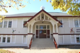
- This landmark school was designed by the architectural firm of Bowman & Cullerne, specialists in the design of educational facilities. After Harold Cullerne (1890-1976) returned from service during the First World War, he joined J.H. Bowman (1864-1943) in a partnership that lasted from 1919 to 1934. The firm’s projects include the Seaforth School (1922, now relocated to Burnaby Village Museum), Burnaby North High School (1923), and the Nelson Avenue School (1927). This was originally designed as a two-storey, four-room building in 1925, with two-storey four-room wings added two years later. The building has been altered with the addition of stucco cladding over the original siding and replacement windows, but has retained its original form and massing, as well as its domed roof ventilator.
- Locality
- Vancouver Heights
- Historic Neighbourhood
- Vancouver Heights (Historic Neighbourhood)
- Planning Study Area
- Willingdon Heights Area
- Architect
- Bowman & Cullerne
- Area
- 20478.11
- Contributing Resource
- Building
- Street Address
- 1351 Gilmore Avenue
- Street View URL
- Google Maps Street View
Images
Masonic Cemetery
https://search.heritageburnaby.ca/link/landmark622
- Repository
- Burnaby Heritage Planning
- Description
- Cemetery site.
- Associated Dates
- 1924
- Street View URL
- Google Maps Street View
- Repository
- Burnaby Heritage Planning
- Geographic Access
- Halifax Street
- Associated Dates
- 1924
- Description
- Cemetery site.
- Heritage Value
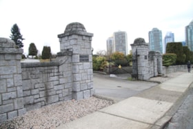
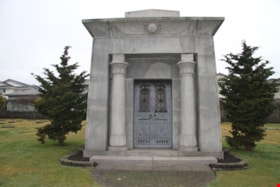
- Tucked into a sloping site in a zone that is now transitional between light industrial and residential uses, the Masonic Cemetery is a beautifully landscaped oasis. Two outstanding features of this cemetery are the Woodward mausoleum, constructed in 1924, and the 1930s entrance gates. These substantial gates are constructed of random-coursed granite, and mark the cemetery’s main entrance off Douglas Road. An elaborate granite mausoleum, built for the prominent Woodward family, is located on axis with the main entry, at the brow of the slope. The Egyptian Revival style of the mausoleum was inspired by the opening of Tutankamun’s tomb just two years earlier, a discovery that sparked world-wide Egyptomania. The Woodward’s department store dynasty was founded by Charles Woodward (1852-1937), who visited Vancouver in 1891 and bought two lots for a store. Woodward’s drug department opened in 1895. In 1901, he took an option on a lot at the corner of Hastings and Abbott Streets and incorporated as Woodward’s Department Stores, which opened in November 1903. The family continued to run the business until 1993, when it went bankrupt and was sold to the Hudson’s Bay Company. A number of the Woodward family are interred here.
- Locality
- Vancouver Heights
- Historic Neighbourhood
- Vancouver Heights (Historic Neighbourhood)
- Planning Study Area
- Willingdon Heights Area
- Area
- 60137.87
- Contributing Resource
- Building
- Landscape Feature
- Ownership
- Private
- Street Address
- 4305 Halifax Street
- Street View URL
- Google Maps Street View
Images
Rosser Elementary School
https://search.heritageburnaby.ca/link/landmark636
- Repository
- Burnaby Heritage Planning
- Description
- School building.
- Associated Dates
- 1923
- Other Names
- NORTH BURNABY HIGH SCHOOL
- Street View URL
- Google Maps Street View
- Repository
- Burnaby Heritage Planning
- Other Names
- NORTH BURNABY HIGH SCHOOL
- Geographic Access
- Pandora Street
- Associated Dates
- 1923
- Description
- School building.
- Heritage Value
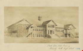
- Originally built as North Burnaby High School, this eight-room school became Rosser Avenue School in 1945. It has been altered with replacement windows, the application of stucco over the original siding and an addition, but has retained its historical form, including a hipped roof with half-timbered gables and a domed roof ventilator. The Rosser Elementary School was designed by the architectural firm of Bowman & Cullerne, who specialized in school design. The firm’s projects include Seaforth School (1922, now relocated to Burnaby Village Museum), Windsor Street School (1923), and Nelson Avenue School (1927).
- Locality
- Vancouver Heights
- Historic Neighbourhood
- Vancouver Heights (Historic Neighbourhood)
- Planning Study Area
- Burnaby Heights Area
- Architect
- Bowman and Cullerne
- Area
- 10579.94
- Contributing Resource
- Building
- Street Address
- 4375 Pandora Street
- Street View URL
- Google Maps Street View
Images
George S. & Jessie Haddon House
https://search.heritageburnaby.ca/link/landmark508
- Repository
- Burnaby Heritage Planning
- Description
- The George and Jessie Haddon House is a symmetrical two-storey Dutch Colonial-style house with a side-gambrel roof and shed dormers. It is situated in the Burnaby Lake neighborhood in East Burnaby.
- Associated Dates
- 1922
- Formal Recognition
- Heritage Designation, Community Heritage Register
- Street View URL
- Google Maps Street View
- Repository
- Burnaby Heritage Planning
- Geographic Access
- Buckingham Avenue
- Associated Dates
- 1922
- Formal Recognition
- Heritage Designation, Community Heritage Register
- Enactment Type
- Bylaw No. 12064
- Enactment Date
- 19/06/2006
- Description
- The George and Jessie Haddon House is a symmetrical two-storey Dutch Colonial-style house with a side-gambrel roof and shed dormers. It is situated in the Burnaby Lake neighborhood in East Burnaby.
- Heritage Value
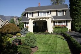
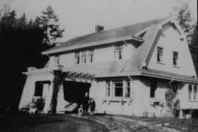
- Built in 1923, the George and Jessie Haddon House is a significant example of the romantic period revival styles that were popular during the period between the two World Wars. These traditionally styled homes reflected ongoing pride in past traditions but also recognized the modern ideals of economy and good design. At the time, houses displayed traditional and readily-identifiable historical styles as a hallmark of good taste. The use of the various Colonial Revival styles had gained new popularity during the 1920s, and this design could have originated in a residential pattern book, which were in wide circulation and used to expedite residential projects. This house displays the typical features of the Dutch Colonial style, imported from the eastern United States and relatively rare on the West Coast. The house originally featured an unusual porte-cochere with tapered supports, that indicated the growing importance of automobiles at the time. The house was built for George Samuel Haddon (1886-1971) and his wife Jessie (née Reade) Haddon, whom he married in 1915. George Haddon, who was born in British Columbia, was a prominent Vancouver figure and served as Secretary of the Vancouver General Hospital. Following Jessie's death, George Haddon was remarried to Alice Margaret Currie (1890-1951). The George and Jessie Haddon House is further valued for its connection with the continued development of the Burnaby Lake neighbourhood in the 1920s. The area was highly desirable to wealthy Vancouver and New Westminster residents because of its scenery, and easy access was provided by the British Columbia Electric Railway 'Burnaby Lake' interurban line, which opened in June 1911. The Haddon House illustrates the evolving nature of regional transportation and the growing communities made possible by increasing options for transportation. The house originally stood on a larger lot, and was relocated in 2006 to allow for subdivision and legal protection. The current owners restored the porte-cochere in 2014.
- Defining Elements
- Key elements that define the heritage character of the George and Jessie Haddon House include its: - location within the Burnaby Lake neighbourhood - residential form, scale and massing as expressed by its two-storey height and gambrel roof with shed dormers - rough-cast stucco cladding - Colonial Revival details such as the symmetrical façade and massing, and side-gambrel roof with shed dormers - additional exterior features such as an interior chimney, exposed purlins and window boxes supported on large projecting brackets - wooden front door with glazed insets - interior features including original staircase, and wooden door and window trim
- Historic Neighbourhood
- Burnaby Lake (Historic Neighbourhood)
- Planning Study Area
- Morley-Buckingham Area
- Builder
- William Dodson
- Function
- Primary Historic--Single Dwelling
- Cadastral Identifier
- P.I.D.026-745-127
- Boundaries
- The George and Jessie Haddon House is comprised of a single residential lot located at 5558 Buckingham Avenue, Burnaby.
- Area
- 1080
- Contributing Resource
- Building
- Ownership
- Private
- Documentation
- City of Burnaby Planning and Building Department, Heritage Site Files
- Street Address
- 5558 Buckingham Avenue
- Street View URL
- Google Maps Street View
Images
Mortimer-Lamb House
https://search.heritageburnaby.ca/link/landmark494
- Repository
- Burnaby Heritage Planning
- Description
- The Mortimer-Lamb House is a one and one half-storey, Arts and Crafts-style residence with a steeply pitched, side-gabled roof. The original cottage form has been enlarged with a later addition on the west side of the house. Located next to the Burnaby Lake Regional Park Wildlife Rescue Care Centre…
- Associated Dates
- c.1922
- Formal Recognition
- Community Heritage Register
- Other Names
- Harold & Katherine Mortimer-Lamb Residence
- Street View URL
- Google Maps Street View
- Repository
- Burnaby Heritage Planning
- Other Names
- Harold & Katherine Mortimer-Lamb Residence
- Geographic Access
- Glencarin Drive
- Associated Dates
- c.1922
- Formal Recognition
- Community Heritage Register
- Enactment Type
- Council Resolution
- Enactment Date
- 26/05/2003
- Description
- The Mortimer-Lamb House is a one and one half-storey, Arts and Crafts-style residence with a steeply pitched, side-gabled roof. The original cottage form has been enlarged with a later addition on the west side of the house. Located next to the Burnaby Lake Regional Park Wildlife Rescue Care Centre, the house has picturesque views of Burnaby Lake.
- Heritage Value
- Built circa 1922, the Mortimer-Lamb House is valued for its association with first owners, Harold Mortimer-Lamb (1872-1970), and his wife, Katherine Mary Mortimer-Lamb (1873-1939). Born in Leatherhead, Surrey, England, Harold Mortimer-Lamb immigrated to Canada in 1889. Seven years later in Vancouver, he married Katherine Mary Lindsay, a native of Winnipeg. Mortimer-Lamb was a key figure in the B.C. mining industry, serving as Secretary of the Mining Association of B.C. between 1900 and 1945, and also as the Secretary of the Canadian Institute of Mining and Metallurgy. In addition to his professional life, Mortimer-Lamb was a pioneer art photographer and was among Canada's leading art critics, and this house served as a central gathering place for renowned Canadian artists of the day. Mortimer-Lamb’s daughter, Molly Lamb Bobak (born 1922), became a renowned watercolourist, and was the only woman ever hired as an official Canadian war artist. The Mortimer-Lamb House is a significant example of the work of noted architect, Samuel Maclure (1860-1929) and his partner, Ross Lort (1889-1969). Maclure, who was a close friend of the Mortimer-Lamb family, was British Columbia's leading residential architect, and was renowned for his high quality designs for prominent citizens in both Vancouver and Victoria. Maclure was a leading exponent of the Art and Crafts design movement in B.C., and established a sophisticated local variation of residential architecture. The Mortimer-Lamb House was designed at the time when Maclure was in partnership with Ross Lort. In 1907, Lort began working for Maclure's firm as a draftsman, and by 1920 was in charge of Maclure's Vancouver office. Lort's architectural career spanned some sixty-years, and he designed some of the province's most familiar houses, apartments, institutions and places of worship. The Mortimer-Lamb House is also a significant local example of the Arts and Crafts style, and incorporates elements such as board-and-batten siding on the ground floor, shingled gables and leaded casement windows. It is a testament to the domestic architecture built outside of established suburbs during the post-First World War era, typically modest in scale and representative of middle-class residential ideals.
- Defining Elements
- Key elements that define the heritage character of the Mortimer-Lamb House include its: - treed setting with views of Burnaby Lake - residential form, scale and massing as expressed by its one and one-half storey height, rectangular plan and steeply pitched side-gabled roof - wood-frame construction - Arts and Crafts elements such as board-and-batten siding on the ground floor, cedar shingles in the gables and open soffits - original straight-leaded casement windows in single and multiple-assembly - internal red-brick chimney with corbelled cap
- Historic Neighbourhood
- Burnaby Lake (Historic Neighbourhood)
- Planning Study Area
- Burnaby Lake Area
- Organization
- Mining Association of B.C.
- G.F. and J. Galt Limited
- Architect
- Samuel Maclure
- Ross Lort
- Function
- Primary Historic--Single Dwelling
- Primary Current--Single Dwelling
- Community
- Burnaby Lake
- Cadastral Identifier
- P.I.D.002-977-788
- Boundaries
- The Mortimer-Lamb House is comprised of a single residential lot located at 5180 Glencairn Drive, Burnaby.
- Area
- 5652.78
- Contributing Resource
- Building
- Ownership
- Private
- Documentation
- City of Burnaby Planning and Building Department, Heritage Site Files
- Street Address
- 5180 Glencarin Drive
- Street View URL
- Google Maps Street View
Images
Fraser Arm Neighbourhood
https://search.heritageburnaby.ca/link/landmark708
- Repository
- Burnaby Heritage Planning
- Associated Dates
- 1925-1954
- Heritage Value
- By the late 1920s, the Fraser Arm Neighbourhood in Burnaby was developing into an industrial and manufacturing district. In 1931, the Canadian National Railway built a bridge over the Fraser River from Burnaby to Lulu Island and advertised that over 30 industries were currently operating along the North Fraser. Along with industries, this district remained an important agricultural area for the Lower Mainland. Chinese market gardens continued to develop and thrive and in 1926, the Vancouver Sun estimated that that Chinese farms in the Lower Fraser Valley then supplied 90 per cent of all green vegetables consumed in the Vancouver market area.
- Historic Neighbourhood
- Fraser Arm (Historic Neighbourhood)
- Planning Study Area
- Big Bend Area
Images
Alta Vista Neighbourhood
https://search.heritageburnaby.ca/link/landmark766
- Repository
- Burnaby Heritage Planning
- Associated Dates
- 1905-1924
- Heritage Value
- Alta Vista, named for its high views of the Fraser Valley, rapidly grew during the period 1910-1912, seeing its settlement jump from about a dozen buildings in 1910 to about four hundred by the end of 1912. Home-seekers were attracted to its location just a short walk from the B.C.E.R. line at Royal Oak and Highland Park and easily accessible to both New Westminster and Vancouver.
- Historic Neighbourhood
- Alta Vista (Historic Neighbourhood)
- Planning Study Area
- Sussex-Nelson Area
Images
Barnet Lumber Company House
https://search.heritageburnaby.ca/link/landmark662
- Repository
- Burnaby Heritage Planning
- Description
- Residential building.
- Associated Dates
- 1925
- Street View URL
- Google Maps Street View
- Repository
- Burnaby Heritage Planning
- Geographic Access
- Texaco Drive
- Associated Dates
- 1925
- Description
- Residential building.
- Heritage Value
- This house is one of two surviving houses built as a “Model Home” for the manager of the Barnet Lumber Company, which was the successor to the North Pacific Lumber Company. It was used as a combined home and office. It was constructed with framing lumber and millwork sawn at the mill. Typical of the Craftsman style, the house has a front gabled roof with triangular eave brackets. It has been altered with the addition of asbestos shingles over the original siding, but retains its form, scale and massing. This house was designed by the firm of Townley & Matheson. The partnership of Fred Laughton Townley (1887-1966) and Robert Michael Matheson began in 1919, and the firm left a rich legacy of sophisticated work, including schools, commercial structures, many fine residences and the landmark Vancouver City Hall.
- Historic Neighbourhood
- Barnet (Historic Neighbourhood)
- Planning Study Area
- Burnaby Mountain Area
- Architect
- Townley & Matheson
- Area
- 2225.77
- Contributing Resource
- Building
- Ownership
- Public (local)
- Street Address
- 8007 Texaco Drive
- Street View URL
- Google Maps Street View
Images
Burnaby Lake Neighbourhood
https://search.heritageburnaby.ca/link/landmark755
- Repository
- Burnaby Heritage Planning
- Associated Dates
- 1905-1924
- Heritage Value
- Along with logging and sawmills, Burnaby became known as a prime agricultural area and the Burnaby Lake Neighbourhood saw the development of many vegetable and fruit farms. Growers in the Burnaby and Deer Lake districts took their produce to the tram line on Edmonds Street and shipped it to markets in New Westminster and Vancouver on a specially designed interurban freight car that was open-sided for easy loading. The car's canvas curtains which sometimes came loose and flapped like wings in the wind led people to dub it "the flying dutchman." Most Burnaby fruit and vegetable growers depended on seasonal Chinese work forces and other local Chinese farm residents to oversee operations; these workers being recruited from New Westminsters' Asian community. Besides being good farmers, Burnaby Lake's early residents fostered a strong sense of community. Both L. Claude Hill and his brother Bernard were elected to Burnaby Municipal council and Bernard was the one who knocked on doors to find enough children to meet the qualifications for establishing a school in the district.
- Historic Neighbourhood
- Burnaby Lake (Historic Neighbourhood)
- Planning Study Area
- Morley-Buckingham Area
- Lakeview-Mayfield Area

