Narrow Results By

Stormont Overpass
https://search.heritageburnaby.ca/link/archivedescription45377
- Repository
- City of Burnaby Archives
- Date
- August 1978
- Collection/Fonds
- Columbian Newspaper collection
- Description Level
- Item
- Physical Description
- 1 photograph : b&w ; 16.5 x 24 cm
- Scope and Content
- Aerial photograph of Stormont Overpass which would provide a direct link from the 401 Freeway to the Lougheed Highway and Simon Fraser University. This was taken when the excavation work was completed, and grading and paving still need to be done.
- Repository
- City of Burnaby Archives
- Date
- August 1978
- Collection/Fonds
- Columbian Newspaper collection
- Physical Description
- 1 photograph : b&w ; 16.5 x 24 cm
- Description Level
- Item
- Record No.
- 480-272
- Access Restriction
- No restrictions
- Reproduction Restriction
- No restrictions
- Accession Number
- 2003-02
- Scope and Content
- Aerial photograph of Stormont Overpass which would provide a direct link from the 401 Freeway to the Lougheed Highway and Simon Fraser University. This was taken when the excavation work was completed, and grading and paving still need to be done.
- Media Type
- Photograph
- Photographer
- Hodge, Craig
- Notes
- Title based on contents of photograph
- Newspaper clipping attached to verso of photograph reads: "After six years, work on the Stormont interchange in Burnaby is only a few weeks from completion. The huge clover-leaf junction of Gaglardi Way and the Freeway is on the top left-hand corner, with Gaglardi Way approaching from the bottom right where a bridge has been completed over the Burlington Northern tracks. An embankment linking that bridge with one over the Brunette River awaits only a layer of tarmac, and a path has been cleared through the woods to link up with the clover-leaf. The present access to the Freeway is along the road running from the left to right across the middle of the picture. The interchange will open next month."
- Note in pencil on verso of photograph reads: "Altair Aviation / photo by / Craig Hodge"
- Geographic Access
- Cariboo Road
- Gaglardi Way
- Trans Canada Highway
- Historic Neighbourhood
- Burquitlam (Historic Neighbourhood)
- Planning Study Area
- Burnaby Lake Area
- Cameron Area
Images

![Stormont Overpass, [1978] thumbnail](/media/hpo/_Data/_Archives_Images/_Unrestricted/480/480-275.jpg?width=280)
Stormont Overpass
https://search.heritageburnaby.ca/link/archivedescription45380
- Repository
- City of Burnaby Archives
- Date
- [1978]
- Collection/Fonds
- Columbian Newspaper collection
- Description Level
- Item
- Physical Description
- 1 photograph : b&w ; 16 x 24 cm
- Scope and Content
- Aerial photograph of Stormont Overpass which would provide a direct link from the Trans Canada Highway (previously named the 401 Freeway) to the Lougheed Highway and Simon Fraser University. This was taken when the excavation work was completed, and paving still need to be done.
- Repository
- City of Burnaby Archives
- Date
- [1978]
- Collection/Fonds
- Columbian Newspaper collection
- Physical Description
- 1 photograph : b&w ; 16 x 24 cm
- Description Level
- Item
- Record No.
- 480-275
- Access Restriction
- No restrictions
- Reproduction Restriction
- No restrictions
- Accession Number
- 2003-02
- Scope and Content
- Aerial photograph of Stormont Overpass which would provide a direct link from the Trans Canada Highway (previously named the 401 Freeway) to the Lougheed Highway and Simon Fraser University. This was taken when the excavation work was completed, and paving still need to be done.
- Media Type
- Photograph
- Photographer
- King, Basil
- Notes
- Title based on contents of photograph
- Note on verso of photograph reads: "One of the biggest Highways"
- Geographic Access
- Cariboo Road
- Gaglardi Way
- Trans Canada Highway
- Historic Neighbourhood
- Burquitlam (Historic Neighbourhood)
- Planning Study Area
- Burnaby Lake Area
- Cameron Area
Images
![Stormont Overpass, [1978] thumbnail](/media/hpo/_Data/_Archives_Images/_Unrestricted/480/480-275.jpg)
![Street clearing, [195-] (date of original), copied 1976 thumbnail](/media/hpo/_Data/_BVM_Images/1974/197602510027.jpg?width=280)
Street clearing
https://search.heritageburnaby.ca/link/museumdescription1622
- Repository
- Burnaby Village Museum
- Date
- [195-] (date of original), copied 1976
- Collection/Fonds
- Burnaby Village Museum Photograph collection
- Description Level
- Item
- Physical Description
- 1 photograph : col. negative ; 4.5 x 6.5 cm
- Scope and Content
- Photograph of the Grandview ramp off of the Trans Canada Highway in Burnaby that is cleared, possibly in preparation for the highway. The clearing for the street is several lanes wide, and in the distance, an overpass bridge can be seen. There are houses and along both sides of the cleared street.
- Repository
- Burnaby Village Museum
- Collection/Fonds
- Burnaby Village Museum Photograph collection
- Description Level
- Item
- Physical Description
- 1 photograph : col. negative ; 4.5 x 6.5 cm
- Scope and Content
- Photograph of the Grandview ramp off of the Trans Canada Highway in Burnaby that is cleared, possibly in preparation for the highway. The clearing for the street is several lanes wide, and in the distance, an overpass bridge can be seen. There are houses and along both sides of the cleared street.
- Accession Code
- HV976.251.27
- Access Restriction
- No restrictions
- Reproduction Restriction
- May be restricted by third party rights
- Date
- [195-] (date of original), copied 1976
- Media Type
- Photograph
- Scan Resolution
- 300
- Scan Date
- 22/8/2006
- Scale
- 100
- Notes
- Title based on contents of photograph
- The print is made as a black and white print from a colour negative film
Images
![Street clearing, [195-] (date of original), copied 1976 thumbnail](/media/hpo/_Data/_BVM_Images/1974/197602510027.jpg)
Surplus Material Disposal - Trans Canada Highway (Vancouver-Fraser River Section)
https://search.heritageburnaby.ca/link/councilreport38510
- Repository
- City of Burnaby Archives
- Report ID
- 34134
- Meeting Date
- 18-Mar-1963
- Format
- Council - Manager's Report
- Manager's Report No.
- 14
- Item No.
- 8
- Collection/Fonds
- City Council and Office of the City Clerk fonds
- Repository
- City of Burnaby Archives
- Report ID
- 34134
- Meeting Date
- 18-Mar-1963
- Format
- Council - Manager's Report
- Manager's Report No.
- 14
- Item No.
- 8
- Collection/Fonds
- City Council and Office of the City Clerk fonds
Documents
Traffic
https://search.heritageburnaby.ca/link/archivedescription80733
- Repository
- City of Burnaby Archives
- Date
- November 16, 1997
- Collection/Fonds
- Burnaby NewsLeader photograph collection
- Description Level
- Item
- Physical Description
- 1 photograph : b&w ; 22.5 x 15.5 cm
- Scope and Content
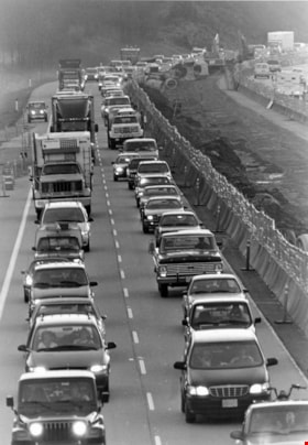
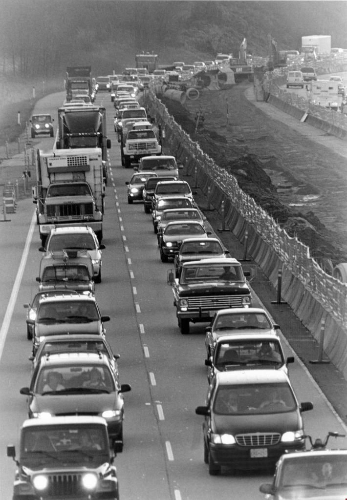
- Photograph of traffic along the Trans Canada highway at the Cariboo interchange, as work continues on High Occupancy Vehicle lane.
- Repository
- City of Burnaby Archives
- Date
- November 16, 1997
- Collection/Fonds
- Burnaby NewsLeader photograph collection
- Physical Description
- 1 photograph : b&w ; 22.5 x 15.5 cm
- Description Level
- Item
- Record No.
- 535-0995
- Access Restriction
- No restrictions
- Reproduction Restriction
- No reproduction permitted
- Accession Number
- 2012-11
- Scope and Content
- Photograph of traffic along the Trans Canada highway at the Cariboo interchange, as work continues on High Occupancy Vehicle lane.
- Subjects
- Geographic Features - Roads
- Media Type
- Photograph
- Photographer
- Ray, Steve
- Notes
- Title based on contents of photograph
- Note in black ink on recto of photograph reads: "Bby Steve 2570 54%"
- Trim marks and/or reproduction instructions on recto (scan is cropped)
Images
Traffic network in northeast Burnaby area generally bounded by North Road, Broadway, Production Way, Trans Canada Highway Sub Areas: (a) Lougheed Town Centre; (b) Sullivan Heights
https://search.heritageburnaby.ca/link/councilreport18501
- Repository
- City of Burnaby Archives
- Report ID
- 2532
- Meeting Date
- 19-Apr-1982
- Format
- Council - Manager's Report
- Manager's Report No.
- 26
- Item No.
- 8
- Collection/Fonds
- City Council and Office of the City Clerk fonds
- Repository
- City of Burnaby Archives
- Report ID
- 2532
- Meeting Date
- 19-Apr-1982
- Format
- Council - Manager's Report
- Manager's Report No.
- 26
- Item No.
- 8
- Collection/Fonds
- City Council and Office of the City Clerk fonds
Documents
Trans-Canada Highway
https://search.heritageburnaby.ca/link/councilreport40735
- Repository
- City of Burnaby Archives
- Report ID
- 36873
- Meeting Date
- 22-Jun-1960
- Format
- Council - Manager's Report
- Manager's Report No.
- 27
- Item No.
- 12
- Collection/Fonds
- City Council and Office of the City Clerk fonds
- Repository
- City of Burnaby Archives
- Report ID
- 36873
- Meeting Date
- 22-Jun-1960
- Format
- Council - Manager's Report
- Manager's Report No.
- 27
- Item No.
- 12
- Collection/Fonds
- City Council and Office of the City Clerk fonds
Documents
Trans Canada Highway - Fraser River Section 4
https://search.heritageburnaby.ca/link/councilreport39500
- Repository
- City of Burnaby Archives
- Report ID
- 36394
- Meeting Date
- 11-Dec-1961
- Format
- Council - Manager's Report
- Manager's Report No.
- 67
- Item No.
- 9
- Collection/Fonds
- City Council and Office of the City Clerk fonds
- Repository
- City of Burnaby Archives
- Report ID
- 36394
- Meeting Date
- 11-Dec-1961
- Format
- Council - Manager's Report
- Manager's Report No.
- 67
- Item No.
- 9
- Collection/Fonds
- City Council and Office of the City Clerk fonds
Documents
Triangular Area bounded by Boundary Road/Clydesdale/Trans Canada Highway
https://search.heritageburnaby.ca/link/councilreport22837
- Repository
- City of Burnaby Archives
- Report ID
- 16316
- Meeting Date
- 15-Aug-1977
- Format
- Council - Manager's Report
- Manager's Report No.
- 55
- Item No.
- 16
- Collection/Fonds
- City Council and Office of the City Clerk fonds
- Repository
- City of Burnaby Archives
- Report ID
- 16316
- Meeting Date
- 15-Aug-1977
- Format
- Council - Manager's Report
- Manager's Report No.
- 55
- Item No.
- 16
- Collection/Fonds
- City Council and Office of the City Clerk fonds
Documents
Triangular Area Bounded by Clydesdale/Trans Canada Highway
https://search.heritageburnaby.ca/link/councilreport23587
- Repository
- City of Burnaby Archives
- Report ID
- 15533
- Meeting Date
- 10-Jan-1977
- Format
- Council - Manager's Report
- Manager's Report No.
- 1
- Item No.
- 13
- Collection/Fonds
- City Council and Office of the City Clerk fonds
- Repository
- City of Burnaby Archives
- Report ID
- 15533
- Meeting Date
- 10-Jan-1977
- Format
- Council - Manager's Report
- Manager's Report No.
- 1
- Item No.
- 13
- Collection/Fonds
- City Council and Office of the City Clerk fonds
Documents
![Wes and Molly Darling on horseback, 1944 (date of original), copied [1991] thumbnail](/media/hpo/_Data/_Archives_Images/_Unrestricted/315/315-249.jpg?width=280)
Wes and Molly Darling on horseback
https://search.heritageburnaby.ca/link/archivedescription36792
- Repository
- City of Burnaby Archives
- Date
- 1944 (date of original), copied [1991]
- Collection/Fonds
- Burnaby Historical Society fonds
- Description Level
- Item
- Physical Description
- 1 photograph : b&w ; 10.1 x 14.9 cm print
- Scope and Content
- Photograph of Wes and Molly Darling on horseback, (during the time that Wes Darling was a soilder) at Willingdon Avenue near the future Trans Canada Highway. The photograph was taken facing south.
- Repository
- City of Burnaby Archives
- Date
- 1944 (date of original), copied [1991]
- Collection/Fonds
- Burnaby Historical Society fonds
- Subseries
- Burnaby Centennial Anthology subseries
- Physical Description
- 1 photograph : b&w ; 10.1 x 14.9 cm print
- Description Level
- Item
- Record No.
- 315-249
- Access Restriction
- No restrictions
- Reproduction Restriction
- No known restrictions
- Accession Number
- BHS1994-04
- Scope and Content
- Photograph of Wes and Molly Darling on horseback, (during the time that Wes Darling was a soilder) at Willingdon Avenue near the future Trans Canada Highway. The photograph was taken facing south.
- Media Type
- Photograph
- Notes
- Title based on contents of photograph
- Geographic Access
- Willingdon Avenue
- Trans Canada Highway
- Historic Neighbourhood
- Broadview (Historic Neighbourhood)
Images
![Wes and Molly Darling on horseback, 1944 (date of original), copied [1991] thumbnail](/media/hpo/_Data/_Archives_Images/_Unrestricted/315/315-249.jpg)

Willingdon Heights Neighbourhood
https://search.heritageburnaby.ca/link/landmark777
- Repository
- Burnaby Heritage Planning
- Associated Dates
- 1955-2008
- Heritage Value
- The convenient location of Willingdon Heights to the Trans Canada Highway, Lougheed Highway and Hastings Street has fostered its development as a primarily residential commuter neighbourhood. Characterised in the post-World War Two period by predominantly single-family developments, the neighbourhood has retained this identity despite some higher density apartment buildings now found there.
- Planning Study Area
- Willingdon Heights Area
Images
