Narrow Results By
Subject
- Advertising Medium - Signs and Signboards 1
- Buildings - Agricultural - Greenhouses 1
- Buildings - Civic 8
- Buildings - Civic - Archives 1
- Buildings - Civic - Art Galleries 2
- Buildings - Civic - City Halls 3
- Buildings - Civic - Fire Halls 1
- Buildings - Civic - Hospitals 2
- Buildings - Civic - Libraries 4
- Buildings - Commercial 5
- Buildings - Commercial - Hotels and Motels 1
- Buildings - Commercial - Offices 1
Person / Organization
- British Columbia Institute of Technology 1
- British Columbia Vocational School 1
- Burnaby City Hall 2
- Burnaby Fire Department 1
- Burnaby Lake Nature House 2
- Burnaby Mountain Park 2
- Burnaby Public Library 4
- Burnaby Winter Club 1
- Capitol Hill Elementary School 1
- Continental Can Co. 2
- Crest Shopping Centre 1
- Edmonds Community School 1

Central Park Veterinary Hospital
https://search.heritageburnaby.ca/link/archivedescription93694
- Repository
- City of Burnaby Archives
- Date
- June 4, 1978
- Collection/Fonds
- Burnaby Public Library Contemporary Visual Archive Project
- Description Level
- Item
- Physical Description
- 1 photograph : b&w ; 12.5 x 17.5 cm
- Scope and Content
- Photograph of the exterior of the Central Park Veterinary Hospital building on Kingsway, opposite Central Park. The photograph is taken from across Kingsway, facing north. The mountains are visible in the background.
- Repository
- City of Burnaby Archives
- Date
- June 4, 1978
- Collection/Fonds
- Burnaby Public Library Contemporary Visual Archive Project
- Physical Description
- 1 photograph : b&w ; 12.5 x 17.5 cm
- Description Level
- Item
- Record No.
- 556-651
- Access Restriction
- No restrictions
- Reproduction Restriction
- Reproduce for fair dealing purposes only
- Accession Number
- 2017-57
- Scope and Content
- Photograph of the exterior of the Central Park Veterinary Hospital building on Kingsway, opposite Central Park. The photograph is taken from across Kingsway, facing north. The mountains are visible in the background.
- Subjects
- Buildings - Commercial
- Media Type
- Photograph
- Photographer
- Surridge, Jack
- Notes
- Title taken from project information form
- Accompanied by a project information form and 1 photograph (b&w negative ; 9.5 x 12.5 cm)
- BPL no. 99
- Geographic Access
- Kingsway
- Central Park
- Historic Neighbourhood
- Central Park (Historic Neighbourhood)
- Planning Study Area
- Maywood Area
Images


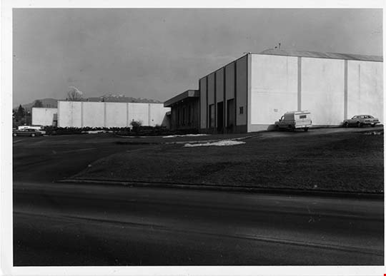
Continental Can Company
https://search.heritageburnaby.ca/link/archivedescription93708
- Repository
- City of Burnaby Archives
- Date
- February 24, 1978
- Collection/Fonds
- Burnaby Public Library Contemporary Visual Archive Project
- Description Level
- Item
- Physical Description
- 1 photograph : b&w ; 12.5 x 17.5 cm
- Scope and Content
- Photograph of the exterior of Continental Can Company factory, located on Winston Street by Burnaby Lake. The photograph is taken from across Winston Street, facing south, and the railway tracks are visible in front of the manufacturing plant. The Continental Can water tower stands in the backgroun…
- Repository
- City of Burnaby Archives
- Date
- February 24, 1978
- Collection/Fonds
- Burnaby Public Library Contemporary Visual Archive Project
- Physical Description
- 1 photograph : b&w ; 12.5 x 17.5 cm
- Description Level
- Item
- Record No.
- 556-665
- Access Restriction
- No restrictions
- Reproduction Restriction
- Reproduce for fair dealing purposes only
- Accession Number
- 2017-57
- Scope and Content
- Photograph of the exterior of Continental Can Company factory, located on Winston Street by Burnaby Lake. The photograph is taken from across Winston Street, facing south, and the railway tracks are visible in front of the manufacturing plant. The Continental Can water tower stands in the background, and there are signs on the side of the road for a "spindle sale" and Braemar Gardens.
- Names
- Continental Can Co.
- Media Type
- Photograph
- Photographer
- Surridge, Jack
- Notes
- Title taken from project information form
- Accompanied by a project information form and 1 photograph (b&w negative ; 9.5 x 12.5 cm)
- BPL no. 113
- Geographic Access
- Winston Street
- Burnaby Lake
- Historic Neighbourhood
- Lozells (Historic Neighbourhood)
- Planning Study Area
- Government Road Area
Images

Cowan Centre & Parking Lot
https://search.heritageburnaby.ca/link/archivedescription93669
- Repository
- City of Burnaby Archives
- Date
- January 18, 1978
- Collection/Fonds
- Burnaby Public Library Contemporary Visual Archive Project
- Description Level
- Item
- Physical Description
- 1 photograph : b&w ; 12.5 x 17.5 cm
- Scope and Content
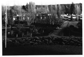
- Photograph of the exterior of the James Cowan Centre (now the James Cowan Theatre at the Shadbolt Centre for the Arts) and the nearby parking lot and gardens. The photograph is taken looking down from a high point, facing east.
- Repository
- City of Burnaby Archives
- Date
- January 18, 1978
- Collection/Fonds
- Burnaby Public Library Contemporary Visual Archive Project
- Physical Description
- 1 photograph : b&w ; 12.5 x 17.5 cm
- Description Level
- Item
- Record No.
- 556-626
- Access Restriction
- No restrictions
- Reproduction Restriction
- Reproduce for fair dealing purposes only
- Accession Number
- 2017-57
- Scope and Content
- Photograph of the exterior of the James Cowan Centre (now the James Cowan Theatre at the Shadbolt Centre for the Arts) and the nearby parking lot and gardens. The photograph is taken looking down from a high point, facing east.
- Names
- James Cowan Theatre
- Media Type
- Photograph
- Photographer
- Surridge, Jack
- Notes
- Title taken from project information form
- Accompanied by a project information form and 1 photograph (b&w negative ; 9.5 x 12.5 cm)
- BPL no. 75
- Street Address
- 6450 Deer Lake Avenue
- Historic Neighbourhood
- Burnaby Lake (Historic Neighbourhood)
- Planning Study Area
- Douglas-Gilpin Area
Images

Crest Neighbourhood Library
https://search.heritageburnaby.ca/link/archivedescription93634
- Repository
- City of Burnaby Archives
- Date
- October 23, 1977
- Collection/Fonds
- Burnaby Public Library Contemporary Visual Archive Project
- Description Level
- Item
- Physical Description
- 1 photograph : b&w ; 12.5 x 17.5 cm
- Scope and Content
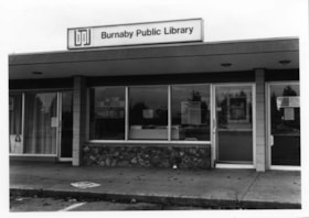
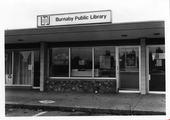
- Photograph of the exterior of the old Crest Neighbourhood Library branch of the Burnaby Public Library that was located at 8679 10th Avenue in the Crest Shopping Centre. The photograph is taken facing west and focuses on the BPL sign and the library's window displays.
- Repository
- City of Burnaby Archives
- Date
- October 23, 1977
- Collection/Fonds
- Burnaby Public Library Contemporary Visual Archive Project
- Physical Description
- 1 photograph : b&w ; 12.5 x 17.5 cm
- Description Level
- Item
- Record No.
- 556-591
- Access Restriction
- No restrictions
- Reproduction Restriction
- Reproduce for fair dealing purposes only
- Accession Number
- 2017-57
- Scope and Content
- Photograph of the exterior of the old Crest Neighbourhood Library branch of the Burnaby Public Library that was located at 8679 10th Avenue in the Crest Shopping Centre. The photograph is taken facing west and focuses on the BPL sign and the library's window displays.
- Subjects
- Buildings - Civic - Libraries
- Media Type
- Photograph
- Photographer
- Surridge, Jack
- Notes
- Title taken from project information form
- Accompanied by a project information form and 1 photograph (b&w negative ; 9.5 x 12.5 cm)
- BPL no. 40
- Street Address
- 8679 10th Avenue
- Historic Neighbourhood
- East Burnaby (Historic Neighbourhood)
- Planning Study Area
- Cariboo-Armstrong Area
Images

Deer Crossing Sign on Road to SFU
https://search.heritageburnaby.ca/link/archivedescription93671
- Repository
- City of Burnaby Archives
- Date
- January 18, 1978
- Collection/Fonds
- Burnaby Public Library Contemporary Visual Archive Project
- Description Level
- Item
- Physical Description
- 1 photograph : b&w ; 12.5 x 17.5 cm
- Scope and Content
- Photograph of the road to Simon Fraser University on Burnaby Mountain, with a deer crossing sign on the right-hand side of the photograph and a car driving ahead. The photograph appears to be taken from a car parked on the shoulder of the road, facing east.
- Repository
- City of Burnaby Archives
- Date
- January 18, 1978
- Collection/Fonds
- Burnaby Public Library Contemporary Visual Archive Project
- Physical Description
- 1 photograph : b&w ; 12.5 x 17.5 cm
- Description Level
- Item
- Record No.
- 556-628
- Access Restriction
- No restrictions
- Reproduction Restriction
- Reproduce for fair dealing purposes only
- Accession Number
- 2017-57
- Scope and Content
- Photograph of the road to Simon Fraser University on Burnaby Mountain, with a deer crossing sign on the right-hand side of the photograph and a car driving ahead. The photograph appears to be taken from a car parked on the shoulder of the road, facing east.
- Names
- Simon Fraser University
- Media Type
- Photograph
- Photographer
- Surridge, Jack
- Notes
- Title taken from project information form
- Accompanied by a project information form and 1 photograph (b&w negative ; 9.5 x 12.5 cm)
- BPL no. 77
- Geographic Access
- University Drive
- Burnaby Mountain Conservation Area
- Planning Study Area
- Burnaby Mountain Area
Images

Delnor Frozen Foods
https://search.heritageburnaby.ca/link/archivedescription93704
- Repository
- City of Burnaby Archives
- Date
- February 15, 1978
- Collection/Fonds
- Burnaby Public Library Contemporary Visual Archive Project
- Description Level
- Item
- Physical Description
- 1 photograph : b&w ; 12.5 x 17.5 cm
- Scope and Content
- Photograph of the exterior of Delnor Frozen Foods manufacturing facility, located at Winston Street and Bainbridge Avenue. The photograph is taken from across the road, facing north. The mountains are visible in the distance.
- Repository
- City of Burnaby Archives
- Date
- February 15, 1978
- Collection/Fonds
- Burnaby Public Library Contemporary Visual Archive Project
- Physical Description
- 1 photograph : b&w ; 12.5 x 17.5 cm
- Description Level
- Item
- Record No.
- 556-661
- Access Restriction
- No restrictions
- Reproduction Restriction
- Reproduce for fair dealing purposes only
- Accession Number
- 2017-57
- Scope and Content
- Photograph of the exterior of Delnor Frozen Foods manufacturing facility, located at Winston Street and Bainbridge Avenue. The photograph is taken from across the road, facing north. The mountains are visible in the distance.
- Subjects
- Buildings - Industrial - Factories
- Media Type
- Photograph
- Photographer
- Surridge, Jack
- Notes
- Title taken from project information form
- Accompanied by a project information form and 1 photograph (b&w negative ; 9.5 x 12.5 cm)
- BPL no. 109
- Geographic Access
- Winston Street
- Bainbridge Avenue
- Planning Study Area
- Government Road Area
Images
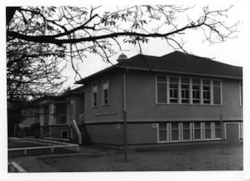
Edmonds Elementary School
https://search.heritageburnaby.ca/link/archivedescription93606
- Repository
- City of Burnaby Archives
- Date
- October 9, 1977
- Collection/Fonds
- Burnaby Public Library Contemporary Visual Archive Project
- Description Level
- Item
- Physical Description
- 1 photograph : b&w ; 12.5 x 17.5 cm
- Scope and Content
- Photograph of the exterior of Edmonds Elementary School, located at Edmonds Street and Canada Way. The photograph is taken facing south.
- Repository
- City of Burnaby Archives
- Date
- October 9, 1977
- Collection/Fonds
- Burnaby Public Library Contemporary Visual Archive Project
- Physical Description
- 1 photograph : b&w ; 12.5 x 17.5 cm
- Description Level
- Item
- Record No.
- 556-563
- Access Restriction
- No restrictions
- Reproduction Restriction
- Reproduce for fair dealing purposes only
- Accession Number
- 2017-57
- Scope and Content
- Photograph of the exterior of Edmonds Elementary School, located at Edmonds Street and Canada Way. The photograph is taken facing south.
- Subjects
- Buildings - Schools
- Names
- Edmonds Community School
- Media Type
- Photograph
- Photographer
- Surridge, Jack
- Notes
- Title taken from project information form
- Accompanied by a project information form and 1 photograph (b&w negative ; 9.5 x 12.5 cm)
- BPL no. 7
- Geographic Access
- Edmonds Street
- Street Address
- 7641 Edmonds Street
- Historic Neighbourhood
- Edmonds (Historic Neighbourhood)
- Planning Study Area
- Edmonds Area
Images

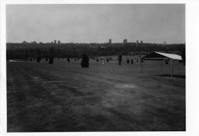
Forest Lawn Cemetery
https://search.heritageburnaby.ca/link/archivedescription93709
- Repository
- City of Burnaby Archives
- Date
- June 4, 1978
- Collection/Fonds
- Burnaby Public Library Contemporary Visual Archive Project
- Description Level
- Item
- Physical Description
- 1 photograph : b&w ; 12.5 x 17.5 cm
- Scope and Content
- Photograph of the grounds of the Forest Lawn Memorial Park cemetery, located by Royal Oak Avenue and Canada Way. Shrubs, gravestones, and a tent are across the lawn. The photograph is taken from on the grounds, facing south. High-rise buildings in the Metrotown area are visible in the distance.
- Repository
- City of Burnaby Archives
- Date
- June 4, 1978
- Collection/Fonds
- Burnaby Public Library Contemporary Visual Archive Project
- Physical Description
- 1 photograph : b&w ; 12.5 x 17.5 cm
- Description Level
- Item
- Record No.
- 556-666
- Access Restriction
- No restrictions
- Reproduction Restriction
- Reproduce for fair dealing purposes only
- Accession Number
- 2017-57
- Scope and Content
- Photograph of the grounds of the Forest Lawn Memorial Park cemetery, located by Royal Oak Avenue and Canada Way. Shrubs, gravestones, and a tent are across the lawn. The photograph is taken from on the grounds, facing south. High-rise buildings in the Metrotown area are visible in the distance.
- Subjects
- Monuments - Gravestones
- Cemeteries
- Media Type
- Photograph
- Photographer
- Surridge, Jack
- Notes
- Title taken from project information form
- Accompanied by a project information form and 1 photograph (b&w negative ; 9.5 x 12.5 cm)
- BPL no. 113
- Geographic Access
- Royal Oak Avenue
- Street Address
- 3789 Royal Oak Avenue
- Historic Neighbourhood
- Burnaby Lake (Historic Neighbourhood)
- Planning Study Area
- Douglas-Gilpin Area
Images


Kensington Overpass Area
https://search.heritageburnaby.ca/link/archivedescription93631
- Repository
- City of Burnaby Archives
- Date
- October 22, 1977
- Collection/Fonds
- Burnaby Public Library Contemporary Visual Archive Project
- Description Level
- Item
- Physical Description
- 1 photograph : b&w ; 12.5 x 17.5 cm
- Scope and Content
- Photograph of the Kensington Overpass area by Lougheed Highway and Sperling Avenue. The overpass was not yet constructed at the time of this photograph but was under discussion by the City of Burnaby Council. The photograph is taken from the side of the road, facing south.
- Repository
- City of Burnaby Archives
- Date
- October 22, 1977
- Collection/Fonds
- Burnaby Public Library Contemporary Visual Archive Project
- Physical Description
- 1 photograph : b&w ; 12.5 x 17.5 cm
- Description Level
- Item
- Record No.
- 556-588
- Access Restriction
- No restrictions
- Reproduction Restriction
- Reproduce for fair dealing purposes only
- Accession Number
- 2017-57
- Scope and Content
- Photograph of the Kensington Overpass area by Lougheed Highway and Sperling Avenue. The overpass was not yet constructed at the time of this photograph but was under discussion by the City of Burnaby Council. The photograph is taken from the side of the road, facing south.
- Media Type
- Photograph
- Photographer
- Surridge, Jack
- Notes
- Title taken from project information form
- Accompanied by a project information form and 1 photograph (b&w negative ; 9.5 x 12.5 cm)
- BPL no. 37
- Geographic Access
- Kensington Avenue
- Sperling Avenue
- Lougheed Highway
- Planning Study Area
- Sperling-Broadway Area
Images

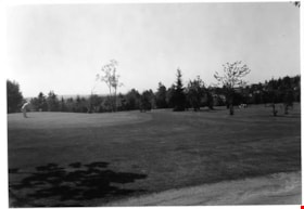
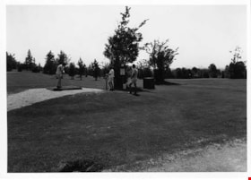
Kensington Pitch & Putt
https://search.heritageburnaby.ca/link/archivedescription93681
- Repository
- City of Burnaby Archives
- Date
- May 27, 1978
- Collection/Fonds
- Burnaby Public Library Contemporary Visual Archive Project
- Description Level
- Item
- Physical Description
- 1 photograph : b&w ; 12.5 x 17.5 cm
- Scope and Content
- Photograph of the greens at Kensington Pitch & Putt golf course, located on the 5800 block of Curtis Street. Two golfers are on the green in the foreground; one is lining up a shot. A small group of golfers is visible in the distance. The photograph is taken from across the green, facing northeast.
- Repository
- City of Burnaby Archives
- Date
- May 27, 1978
- Collection/Fonds
- Burnaby Public Library Contemporary Visual Archive Project
- Physical Description
- 1 photograph : b&w ; 12.5 x 17.5 cm
- Description Level
- Item
- Record No.
- 556-638
- Access Restriction
- No restrictions
- Reproduction Restriction
- Reproduce for fair dealing purposes only
- Accession Number
- 2017-57
- Scope and Content
- Photograph of the greens at Kensington Pitch & Putt golf course, located on the 5800 block of Curtis Street. Two golfers are on the green in the foreground; one is lining up a shot. A small group of golfers is visible in the distance. The photograph is taken from across the green, facing northeast.
- Media Type
- Photograph
- Photographer
- Surridge, Jack
- Notes
- Title taken from project information form
- Accompanied by a project information form and 1 photograph (b&w negative ; 9.5 x 12.5 cm)
- BPL no. 87
- Street Address
- 5889 Curtis Street
- 6159 Curtis Street
- Planning Study Area
- Parkcrest-Aubrey Area
Images

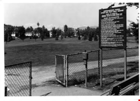
Kensington Pitch & Putt
https://search.heritageburnaby.ca/link/archivedescription93682
- Repository
- City of Burnaby Archives
- Date
- May 27, 1978
- Collection/Fonds
- Burnaby Public Library Contemporary Visual Archive Project
- Description Level
- Item
- Physical Description
- 1 photograph : b&w ; 12.5 x 17.5 cm
- Scope and Content
- Photograph of the Kensington Pitch & Putt Golf Course on the 5800 block of Curtis Street. The photograph shows a sign displaying the rules and etiquette for the golf course in the foreground, next to a chainlink fence. The photograph is taken facing northwest, and the mountains are visible in the d…
- Repository
- City of Burnaby Archives
- Date
- May 27, 1978
- Collection/Fonds
- Burnaby Public Library Contemporary Visual Archive Project
- Physical Description
- 1 photograph : b&w ; 12.5 x 17.5 cm
- Description Level
- Item
- Record No.
- 556-639
- Access Restriction
- No restrictions
- Reproduction Restriction
- Reproduce for fair dealing purposes only
- Accession Number
- 2017-57
- Scope and Content
- Photograph of the Kensington Pitch & Putt Golf Course on the 5800 block of Curtis Street. The photograph shows a sign displaying the rules and etiquette for the golf course in the foreground, next to a chainlink fence. The photograph is taken facing northwest, and the mountains are visible in the distance.
- Media Type
- Photograph
- Photographer
- Surridge, Jack
- Notes
- Title taken from project information form
- Accompanied by a project information form and 1 photograph (b&w negative ; 9.5 x 12.5 cm)
- BPL no. 88
- Street Address
- 5889 Curtis Street
- 6159 Curtis Street
- Planning Study Area
- Parkcrest-Aubrey Area
Images

Kensington Pitch & Putt
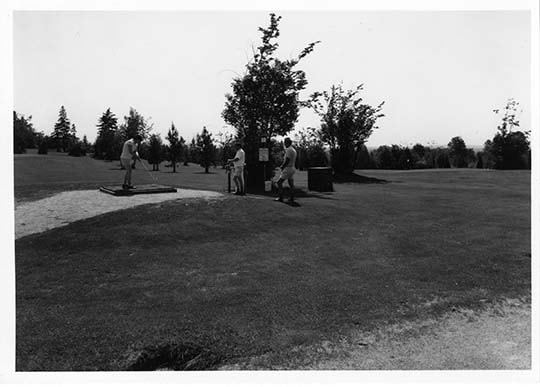
https://search.heritageburnaby.ca/link/archivedescription93683
- Repository
- City of Burnaby Archives
- Date
- May 27, 1978
- Collection/Fonds
- Burnaby Public Library Contemporary Visual Archive Project
- Description Level
- Item
- Physical Description
- 1 photograph : b&w ; 12.5 x 17.5 cm
- Scope and Content
- Photograph of the Kensington Pitch & Putt Golf Course on the 5800 block of Curtis Street. Three golfers are on the green; one is lining up a shot on the teeing green. The photograph is taken facing southeast.
- Repository
- City of Burnaby Archives
- Date
- May 27, 1978
- Collection/Fonds
- Burnaby Public Library Contemporary Visual Archive Project
- Physical Description
- 1 photograph : b&w ; 12.5 x 17.5 cm
- Description Level
- Item
- Record No.
- 556-640
- Access Restriction
- No restrictions
- Reproduction Restriction
- Reproduce for fair dealing purposes only
- Accession Number
- 2017-57
- Scope and Content
- Photograph of the Kensington Pitch & Putt Golf Course on the 5800 block of Curtis Street. Three golfers are on the green; one is lining up a shot on the teeing green. The photograph is taken facing southeast.
- Media Type
- Photograph
- Photographer
- Surridge, Jack
- Notes
- Title taken from project information form
- Accompanied by a project information form and 1 photograph (b&w negative ; 9.5 x 12.5 cm)
- BPL no. 88
- Street Address
- 5889 Curtis Street
- 6159 Curtis Street
- Planning Study Area
- Parkcrest-Aubrey Area
Images

Knapps Garden Shop
https://search.heritageburnaby.ca/link/archivedescription93630
- Repository
- City of Burnaby Archives
- Date
- October 22, 1977
- Collection/Fonds
- Burnaby Public Library Contemporary Visual Archive Project
- Description Level
- Item
- Physical Description
- 1 photograph : b&w ; 12.5 x 17.5 cm
- Repository
- City of Burnaby Archives
- Date
- October 22, 1977
- Collection/Fonds
- Burnaby Public Library Contemporary Visual Archive Project
- Physical Description
- 1 photograph : b&w ; 12.5 x 17.5 cm
- Description Level
- Item
- Record No.
- 556-587
- Access Restriction
- No restrictions
- Reproduction Restriction
- Reproduce for fair dealing purposes only
- Accession Number
- 2017-57
- Media Type
- Photograph
- Photographer
- Surridge, Jack
- Notes
- Title taken from project information form
- Accompanied by a project information form and 1 photograph (b&w negative ; 9.5 x 12.5 cm)
- BPL no. 36
- Geographic Access
- Lougheed Highway
- Holdom Avenue
- Planning Study Area
- Ardingley-Sprott Area
Images


Lenkurt Electric
https://search.heritageburnaby.ca/link/archivedescription93626
- Repository
- City of Burnaby Archives
- Date
- October 23, 1977
- Collection/Fonds
- Burnaby Public Library Contemporary Visual Archive Project
- Description Level
- Item
- Physical Description
- 1 photograph : b&w ; 12.5 x 17.5 cm
- Scope and Content
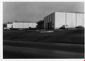
- Photograph of the exterior of Lenkurt Electric, the telecommunications equipment manufacturing plant, on Lougheed Highway at Bainbridge Avenue. The photograph is taken facing south, from across the road.
- Repository
- City of Burnaby Archives
- Date
- October 23, 1977
- Collection/Fonds
- Burnaby Public Library Contemporary Visual Archive Project
- Physical Description
- 1 photograph : b&w ; 12.5 x 17.5 cm
- Description Level
- Item
- Record No.
- 556-583
- Access Restriction
- No restrictions
- Reproduction Restriction
- Reproduce for fair dealing purposes only
- Accession Number
- 2017-57
- Scope and Content
- Photograph of the exterior of Lenkurt Electric, the telecommunications equipment manufacturing plant, on Lougheed Highway at Bainbridge Avenue. The photograph is taken facing south, from across the road.
- Media Type
- Photograph
- Photographer
- Surridge, Jack
- Notes
- Title taken from project information form
- Accompanied by a project information form and 1 photograph (b&w negative ; 9.5 x 12.5 cm)
- BPL no. 30
- Geographic Access
- Lougheed Highway
- Bainbridge Avenue
- Street Address
- 7018 Lougheed Highway
- Historic Neighbourhood
- Lozells (Historic Neighbourhood)
- Planning Study Area
- Government Road Area
Images


Lochdale Community Hall
https://search.heritageburnaby.ca/link/archivedescription93672
- Repository
- City of Burnaby Archives
- Date
- January 18, 1978
- Collection/Fonds
- Burnaby Public Library Contemporary Visual Archive Project
- Description Level
- Item
- Physical Description
- 1 photograph : b&w ; 12.5 x 17.5 cm
- Scope and Content
- Photograph of the front exterior of Lochdale Community Hall, located near Sperling and Hastings Street and built in 1925. Cars are parked in front of and beside the hall. The photograph is taken from across the street, facing east.
- Repository
- City of Burnaby Archives
- Date
- January 18, 1978
- Collection/Fonds
- Burnaby Public Library Contemporary Visual Archive Project
- Physical Description
- 1 photograph : b&w ; 12.5 x 17.5 cm
- Description Level
- Item
- Record No.
- 556-629
- Access Restriction
- No restrictions
- Reproduction Restriction
- Reproduce for fair dealing purposes only
- Accession Number
- 2017-57
- Scope and Content
- Photograph of the front exterior of Lochdale Community Hall, located near Sperling and Hastings Street and built in 1925. Cars are parked in front of and beside the hall. The photograph is taken from across the street, facing east.
- Names
- Lochdale Community Hall
- Media Type
- Photograph
- Photographer
- Surridge, Jack
- Notes
- Title taken from project information form
- Accompanied by a project information form and 1 photograph (b&w negative ; 9.5 x 12.5 cm)
- BPL no. 78
- Geographic Access
- Hastings Street
- Sperling Avenue
- Street Address
- 490 Sperling Avenue
- Historic Neighbourhood
- Lochdale (Historic Neighbourhood)
- Planning Study Area
- Lochdale Area
Images


Lougheed Hotel
https://search.heritageburnaby.ca/link/archivedescription93625
- Repository
- City of Burnaby Archives
- Date
- October 23, 1977
- Collection/Fonds
- Burnaby Public Library Contemporary Visual Archive Project
- Description Level
- Item
- Physical Description
- 1 photograph : b&w ; 12.5 x 17.5 cm
- Scope and Content
- Photograph of the Lougheed Hotel on Lougheed Highway near Willingdon Avenue. The photograph is taken facing west and shows the hotel's sign, parking lot, and main hotel building.
- Repository
- City of Burnaby Archives
- Date
- October 23, 1977
- Collection/Fonds
- Burnaby Public Library Contemporary Visual Archive Project
- Physical Description
- 1 photograph : b&w ; 12.5 x 17.5 cm
- Description Level
- Item
- Record No.
- 556-582
- Access Restriction
- No restrictions
- Reproduction Restriction
- Reproduce for fair dealing purposes only
- Accession Number
- 2017-57
- Scope and Content
- Photograph of the Lougheed Hotel on Lougheed Highway near Willingdon Avenue. The photograph is taken facing west and shows the hotel's sign, parking lot, and main hotel building.
- Names
- Lougheed Hotel
- Media Type
- Photograph
- Photographer
- Surridge, Jack
- Notes
- Title taken from project information form
- Accompanied by a project information form and 1 photograph (b&w negative ; 9.5 x 12.5 cm)
- BPL no. 29
- Street Address
- 4343 Lougheed Highway
- Historic Neighbourhood
- Vancouver Heights (Historic Neighbourhood)
- Planning Study Area
- Willingdon Heights Area
Images


Mathers House Cowan Centre
https://search.heritageburnaby.ca/link/archivedescription93670
- Repository
- City of Burnaby Archives
- Date
- January 18, 1978
- Collection/Fonds
- Burnaby Public Library Contemporary Visual Archive Project
- Description Level
- Item
- Physical Description
- 1 photograph : b&w ; 12.5 x 17.5 cm
- Scope and Content
- Photograph of the rear exterior of Mathers House (Altnadene), which was purchased by Burnaby in 1971 for use as part of the James Cowan Centre, now the Shadbolt Centre for the Arts. The photograph is taken facing southeast.
- Repository
- City of Burnaby Archives
- Date
- January 18, 1978
- Collection/Fonds
- Burnaby Public Library Contemporary Visual Archive Project
- Physical Description
- 1 photograph : b&w ; 12.5 x 17.5 cm
- Description Level
- Item
- Record No.
- 556-627
- Access Restriction
- No restrictions
- Reproduction Restriction
- Reproduce for fair dealing purposes only
- Accession Number
- 2017-57
- Scope and Content
- Photograph of the rear exterior of Mathers House (Altnadene), which was purchased by Burnaby in 1971 for use as part of the James Cowan Centre, now the Shadbolt Centre for the Arts. The photograph is taken facing southeast.
- Media Type
- Photograph
- Photographer
- Surridge, Jack
- Notes
- Title taken from project information form
- Accompanied by a project information form and 1 photograph (b&w negative ; 9.5 x 12.5 cm)
- BPL no. 76
- Street Address
- 6490 Deer Lake Avenue
- Historic Neighbourhood
- Burnaby Lake (Historic Neighbourhood)
- Planning Study Area
- Douglas-Gilpin Area
Images

![Mental Health Building, November 13, [1977] thumbnail](/media/hpo/_Data/_Archives_Images/_Unrestricted/550/556-595.jpg?width=280)
Mental Health Building
https://search.heritageburnaby.ca/link/archivedescription93638
- Repository
- City of Burnaby Archives
- Date
- November 13, [1977]
- Collection/Fonds
- Burnaby Public Library Contemporary Visual Archive Project
- Description Level
- Item
- Physical Description
- 1 photograph : b&w ; 12.5 x 17.5 cm
- Scope and Content
- Photograph of the exterior of one of the buildings of the Burnaby Mental Health Centre, located on Willingdon Avenue. Two directional signs are in front of the building; one points to the Burnaby Psychiatric Services and the British Columbia Youth Development Centre and Psychological Education Clin…
- Repository
- City of Burnaby Archives
- Date
- November 13, [1977]
- Collection/Fonds
- Burnaby Public Library Contemporary Visual Archive Project
- Physical Description
- 1 photograph : b&w ; 12.5 x 17.5 cm
- Description Level
- Item
- Record No.
- 556-595
- Access Restriction
- No restrictions
- Reproduction Restriction
- Reproduce for fair dealing purposes only
- Accession Number
- 2017-57
- Scope and Content
- Photograph of the exterior of one of the buildings of the Burnaby Mental Health Centre, located on Willingdon Avenue. Two directional signs are in front of the building; one points to the Burnaby Psychiatric Services and the British Columbia Youth Development Centre and Psychological Education Clinic "The Maples." The photograph is taken from across the intersection, facing north.
- Media Type
- Photograph
- Photographer
- Surridge, Jack
- Notes
- Title taken from project information form
- Accompanied by a project information form and 1 photograph (b&w negative ; 9.5 x 12.5 cm)
- BPL no. 44
- Geographic Access
- Willingdon Avenue
- Street Address
- 3405 Willingdon Avenue
- Planning Study Area
- Douglas-Gilpin Area
Images
![Mental Health Building, November 13, [1977] thumbnail](/media/hpo/_Data/_Archives_Images/_Unrestricted/550/556-595.jpg)
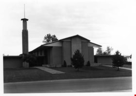
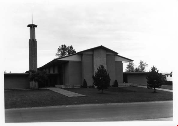
Mormon Church & Genealogical Library
https://search.heritageburnaby.ca/link/archivedescription93633
- Repository
- City of Burnaby Archives
- Date
- October 27, 1977
- Collection/Fonds
- Burnaby Public Library Contemporary Visual Archive Project
- Description Level
- Item
- Physical Description
- 1 photograph : b&w ; 12.5 x 17.5 cm
- Scope and Content
- Photograph of the exterior of The Church of Jesus Christ of Latter Day Saints and its Family History Centre, located at 5280 Kincaid Street. The photograph is taken from across the street, facing southwest.
- Repository
- City of Burnaby Archives
- Date
- October 27, 1977
- Collection/Fonds
- Burnaby Public Library Contemporary Visual Archive Project
- Physical Description
- 1 photograph : b&w ; 12.5 x 17.5 cm
- Description Level
- Item
- Record No.
- 556-590
- Access Restriction
- No restrictions
- Reproduction Restriction
- Reproduce for fair dealing purposes only
- Accession Number
- 2017-57
- Scope and Content
- Photograph of the exterior of The Church of Jesus Christ of Latter Day Saints and its Family History Centre, located at 5280 Kincaid Street. The photograph is taken from across the street, facing southwest.
- Subjects
- Buildings - Religious - Churches
- Media Type
- Photograph
- Photographer
- Surridge, Jack
- Notes
- Title taken from project information form
- Accompanied by a project information form and 1 photograph (b&w negative ; 9.5 x 12.5 cm)
- BPL no. 39
- Geographic Access
- Kincaid Street
- Street Address
- 5280 Kincaid Street
- Historic Neighbourhood
- Burnaby Lake (Historic Neighbourhood)
- Planning Study Area
- Douglas-Gilpin Area
Images

Nature House
https://search.heritageburnaby.ca/link/archivedescription93628
- Repository
- City of Burnaby Archives
- Date
- October 22, 1977
- Collection/Fonds
- Burnaby Public Library Contemporary Visual Archive Project
- Description Level
- Item
- Physical Description
- 1 photograph : b&w ; 12.5 x 17.5 cm
- Scope and Content
- Photograph of the Burnaby Lake Nature House at 4519 Piper Avenue in Burnaby Lake Regional Park. The photograph is taken facing southwest. The Nature House was built in 1940. The sign for the Nature House is just visible on the left side of the photograph, and canoes are stacked outside beside the b…
- Repository
- City of Burnaby Archives
- Date
- October 22, 1977
- Collection/Fonds
- Burnaby Public Library Contemporary Visual Archive Project
- Physical Description
- 1 photograph : b&w ; 12.5 x 17.5 cm
- Description Level
- Item
- Record No.
- 556-585
- Access Restriction
- No restrictions
- Reproduction Restriction
- Reproduce for fair dealing purposes only
- Accession Number
- 2017-57
- Scope and Content
- Photograph of the Burnaby Lake Nature House at 4519 Piper Avenue in Burnaby Lake Regional Park. The photograph is taken facing southwest. The Nature House was built in 1940. The sign for the Nature House is just visible on the left side of the photograph, and canoes are stacked outside beside the building.
- Media Type
- Photograph
- Photographer
- Surridge, Jack
- Notes
- Title taken from project information form
- Accompanied by a project information form and 1 photograph (b&w negative ; 9.5 x 12.5 cm)
- BPL no. 34
- Geographic Access
- Burnaby Lake Regional Nature Park
- Street Address
- 4519 Piper Avenue
- Historic Neighbourhood
- Lozells (Historic Neighbourhood)
- Planning Study Area
- Burnaby Lake Area
Images
