Narrow Results By
![Esther Love Stanley photograph album 1, [1900-1928] thumbnail](/media/hpo/_Data/_BVM_Images/2022/2022_0032_0001_003.jpg?width=280)
Esther Love Stanley photograph album 1
https://search.heritageburnaby.ca/link/museumdescription19284
- Repository
- Burnaby Village Museum
- Date
- [1900-1928]
- Collection/Fonds
- Esther Love Stanley fonds
- Description Level
- File
- Physical Description
- 1 photograph album (429 photographs)
- Scope and Content
- Photograph album consists of photographs of various members of the Love family, relatives, friends and descendants including the members of the Brandrith, Stanley, Whiting and MacKenzie families. Album includes photographs taken by family members as well as portrait photographers that document even…
- Repository
- Burnaby Village Museum
- Collection/Fonds
- Esther Love Stanley fonds
- Description Level
- File
- Physical Description
- 1 photograph album (429 photographs)
- Scope and Content
- Photograph album consists of photographs of various members of the Love family, relatives, friends and descendants including the members of the Brandrith, Stanley, Whiting and MacKenzie families. Album includes photographs taken by family members as well as portrait photographers that document events, celebrations, gatherings, travels throughout British Columbia, various residences and vacation homes. Album and annotations were created by Esther Love Stanley and descendants.
- Creator
- Stanley, Esther Love
- Accession Code
- BV022.32.1
- Access Restriction
- No restrictions
- Reproduction Restriction
- No known restrictions
- Date
- [1900-1928]
- Media Type
- Photograph
- Notes
- Title based on contents of album
- Individual photographs within album are described at item level BV022.32.2 to BV022.32.430
- Duplicate photographs within album were not accessioned or described
Images
![Esther Love Stanley photograph album 1, [1900-1928] thumbnail](/media/hpo/_Data/_BVM_Images/2022/2022_0032_0001_003.jpg)
Documents

5th Burnaby Brownie Pack scrapbook
https://search.heritageburnaby.ca/link/museumdescription4584
- Repository
- Burnaby Village Museum
- Date
- 1948-1965
- Collection/Fonds
- Burnaby Girl Guides fonds
- Description Level
- File
- Physical Description
- 1 scrapbook (2 digital files : (pdfs) + 58 photographs : col. (tiffs)) + 1 file of textual records + photographs + illustrations + ephemera
- Scope and Content
- File consists of images and original records from a scrapbook that was created by Mrs.M. Bate during her involvement with Burnaby Girl Guides. The original scrapbook is titled: "Scrapbook / Presented to / 5th Burnaby Brownie Pack / by Mrs. M. Bate / April 7th 1948" . The scrapbook contains 62 photo…
- Repository
- Burnaby Village Museum
- Collection/Fonds
- Burnaby Girl Guides fonds
- Description Level
- File
- Physical Description
- 1 scrapbook (2 digital files : (pdfs) + 58 photographs : col. (tiffs)) + 1 file of textual records + photographs + illustrations + ephemera
- Scope and Content
- File consists of images and original records from a scrapbook that was created by Mrs.M. Bate during her involvement with Burnaby Girl Guides. The original scrapbook is titled: "Scrapbook / Presented to / 5th Burnaby Brownie Pack / by Mrs. M. Bate / April 7th 1948" . The scrapbook contains 62 photographs, newspaper clippings, original artwork and memorabilia for 5th Brownie Pack; 1948 to 1965. Many of the photographs are described with notes on each page, some photographs refer to : a group photo of brownies and leaders gathered on April 7th, 1948 for the "Presentation of 3 Proficiency Badges and 17 Golden Bars" outside [St. Alban's church]; A Guide Rally at Hastings Auditorium; Sports Day events held at Stanley Park June 1948; Girl Guide parade floats for Community Day 1949 and 1950; Lady Baden-Powell in Vancouver ca. 1952; 3rd Brownie Pack Easter visit to Eatons; Christmas Party 1958 and a Gathering of Guides and Scouts on Burnaby Mountain [1961].Scrapbook also includes various awards, certificates, original artwork, correspondence and a pop up Christmas Card.
- Creator
- Bate, May
- Accession Code
- BV015.35.156
- Access Restriction
- No restrictions
- Reproduction Restriction
- May be restricted by third party rights
- Date
- 1948-1965
- Media Type
- Photograph
- Textual Record
- Notes
- Title based on contents of file
- Digital images were created of the scrapbook prior to selective retention of original records
- A selection of textual records have been retained under BV015.35.156
- A selection of photographs from scrapbook have been retained and some are described at item level (BV015.35.169 to BV015.35.188)
- Christmas card is described separately under BV015.35.332
Images

Documents
![Survey and Subdivision plans in New Westminster District Group 1 – Burnaby, Port Moody, [1862-1908] thumbnail](/media/hpo/_Data/_BVM_Cartographic_Material/1977/1977_0093_0026a_001.jpg?width=280)
Survey and Subdivision plans in New Westminster District Group 1 – Burnaby, Port Moody
https://search.heritageburnaby.ca/link/museumdescription6995
- Repository
- Burnaby Village Museum
- Date
- [1862-1908]
- Collection/Fonds
- Burnaby Village Museum Map collection
- Description Level
- File
- Physical Description
- 9 plans : 6 plans : black ink on paper ; 57 x 36.5 cm or smaller + 1 plan : black ink and grahite on paper ; 46.5 x 49 cm + 1 plan : blueprint on paper ; 15.5 x 19.5 cm + cm + 1 plan : graphite on paper ; 25 x 17 cm ; mounted on both sides of board 76 x 102 cm
- Scope and Content
- Item consists of a large board of four New Westminster District subdivision plans mounted on one side and five New Westminster District subdivision plans mounted on the other side. Side A: 1. "Plan / of Subdivision / of a Portion / of / Lot 87 / Group One / New Westminster District / Scale 4 chs…
- Repository
- Burnaby Village Museum
- Collection/Fonds
- Burnaby Village Museum Map collection
- Description Level
- File
- Physical Description
- 9 plans : 6 plans : black ink on paper ; 57 x 36.5 cm or smaller + 1 plan : black ink and grahite on paper ; 46.5 x 49 cm + 1 plan : blueprint on paper ; 15.5 x 19.5 cm + cm + 1 plan : graphite on paper ; 25 x 17 cm ; mounted on both sides of board 76 x 102 cm
- Material Details
- Scales [between 1:792 and 1:3600]
- Index number on edge of board reads: "26"
- Scope and Content
- Item consists of a large board of four New Westminster District subdivision plans mounted on one side and five New Westminster District subdivision plans mounted on the other side. Side A: 1. "Plan / of Subdivision / of a Portion / of / Lot 87 / Group One / New Westminster District / Scale 4 chs = 1 in". Plan is stamped: "Albert J. Hill, Civil Engineer / and / Provincial Land Surveyor, / New Westminster, / B.C." and intialed by: "RB" [sic] (in blue pencil crayon). Names two of the subdivisons of District Lot 87 are identified as, "L.E. Sprott" and "John Ledger". (Geographic location: Burnaby) 2. "Plan of Subdivision / of / Portions of / Lot 136, 131 and Lots 44 and 78 Gr.1 / New Westminster District / Scale 300 ft = 1 inch". Annotation above title reads: "No. 901 / Deposited in Land Registry Office / New Westminster / Aug. 19th 1905 / Charles S. Keith D. Reg." Annotations and signatures at bottom of plan read: "I, William Nelson Draper, / W.H.R. Collister / Charles E. Perkins / E.B. Morgan / make / Surveys / correct / representation / upon / the / Land Registry Act / (sgd) W.N. Draper, P.L.S.". Plan includes a handwritten title: "Lots 136, 131, 44 & 78" and is initialed: "RB" [sic] (in blue pencil crayon) (Geographic location: Burnaby) 3. "Survey / of / a Portion / of / Lot 95, Gr.1 / Scale 1 ch = 1in." Plan is stamped: "Albert J. Hill, Civil Engineer / and / Provincial Land Surveyor, / New Westminster, / B.C." and is initialed : "RB" [sic] (in blue pencil crayon) (Geographic location: Burnaby) 4. Blueprint plan of "Lot 396. Group One." with Scale : 3 chs = 1 in. A two acre portion of District Lot 396 is filled in with red ink." Plan is signed by "Albert J. Hill / B.C.L.S." (Geographic location: Port Moody) Side B: 1. Plan titled "District Lot 92 / Burnaby / Municipality / for sale by / Mahon / McFarland & / Mahon Ltd. / Vancouver, B.C. / Scale : 4 chains to one inch". District Lot 92 is subdivided into 161 lots and identifies roads: Norwich Road, Pole Line Road, Oakland Road, Stanley Road, Burford Road, Dalhousie Road, Brantford Road, Colborne Road, Roberts Road, Vancouver & Westminster Road, B.C. Electric Railway, Gilley Stn. and Burnaby (Power House). The bottom of the plan reads: "G.S. Dawson, P.LS. Vancouver, B.C." (Geographic location: Burnaby) 2. "Plan / of Subdivision / of a Portion / of / Lot 29 / Group 1 / New Westminster District / Scale 2 chs = 1 in". Plan is stamped: "Albert J. Hill, Civil Engineer / and / Provincial Land Surveyor, / New Westminster, / B.C." and is initialed by: "RB" [sic] (in blue pencil crayon) (Geographic location: Burnaby) 3. Small handrawn plan (no title) identifying "Lot 84 / Hydes, Claim" at the centre surrounded by lots and features identified as: "Lot 85", "Lot 93", "Lot 94", "Lot 32", "Lot 82", "Lot 83", "Lot 79", "swamp" and a "Small Lake" (Burnaby Lake). Identifying marks in the right corner of the plan read: "Page 13 / Surveyed by G. Turner / May 62". Plan also includes surveyor's bearing measurements and trails to "Small Lake" (Burnaby Lake). (Geographic location: Burnaby) 4. Untitled plan showing District Lots west of North Road and north of Burnaby Lake including: Lots 2, 4, 6, 8, 15, 10, 56, 148, 57, 58, 40. and Lots 3, 5, 7 east of North Road (Coquitlam). Lots in Burnaby are identifed for timber including: "Heavily Timbered" (Lot 57), " "Some Fir and Cedar" (Lot 40), "Splendid Fir and Cedar" (Lot 143), "Heavy Fir etc" (Lots 143 and 148), " "Fine Cedar" (Lot 15), "Rough Light Timber" (Lot 56). Other features identified at the lower portion of the plan include "Burnaby Lake" and "Brunette River". (Geographic location: Burnaby) 5. Untitled plan drawn in graphite showing sections of District Lot 85 south of Burnaby Lake and north of Hazsard Road. Plan is signed: "Albert J. Hill / B.C.L.S." and dated "12/26/08". Plan is initialed by: "RB" [sic] (in blue pencil crayon) (Geographic location: Burnaby)
- Publisher
- Mahon, McFarland & Mahon Ltd
- Accession Code
- HV977.93.26
- Access Restriction
- No restrictions
- Reproduction Restriction
- No known restrictions
- Date
- [1862-1908]
- Media Type
- Cartographic Material
- Historic Neighbourhood
- Burnaby Lake (Historic Neighbourhood)
- Burquitlam (Historic Neighbourhood)
- Planning Study Area
- Burnaby Lake Area
- Scan Resolution
- 300
- Scale
- 72
- Notes
- Title based on contents of file
- Scale is measured in chains and feet. (One chain equals 792 inches)
- The term "Lot" can also refer to a "District Lot”
Images
![Survey and Subdivision plans in New Westminster District Group 1 – Burnaby, Port Moody, [1862-1908] thumbnail](/media/hpo/_Data/_BVM_Cartographic_Material/1977/1977_0093_0026a_001.jpg)


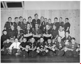
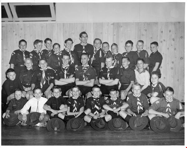
Troup photographs
https://search.heritageburnaby.ca/link/archivedescription55157
- Repository
- City of Burnaby Archives
- Date
- 1969-1975
- Collection/Fonds
- Burnaby Historical Society fonds
- Description Level
- File
- Physical Description
- 16 photographs : b&w and col. ; 18 cm x 23 cm and smaller
- Scope and Content
- Group portraits of various Boy Scout troops including: 1st Southview Cub Pack, 5th Burnaby West, 5th Burnaby Heights Troop, 5th Burnaby West Nootka Wolf Cub Pack, and 7th West Cubs. The portrait of 1st Southview Cub Pack is adhered to paper along with a green and red Boy Scouts badge. File also i…
- Repository
- City of Burnaby Archives
- Date
- 1969-1975
- Collection/Fonds
- Burnaby Historical Society fonds
- Subseries
- Burnaby Scouts subseries
- Physical Description
- 16 photographs : b&w and col. ; 18 cm x 23 cm and smaller
- Description Level
- File
- Record No.
- 631-039
- Access Restriction
- No restrictions
- Reproduction Restriction
- Reproduce for fair dealing purposes only
- Accession Number
- BHS1994-05
- Scope and Content
- Group portraits of various Boy Scout troops including: 1st Southview Cub Pack, 5th Burnaby West, 5th Burnaby Heights Troop, 5th Burnaby West Nootka Wolf Cub Pack, and 7th West Cubs. The portrait of 1st Southview Cub Pack is adhered to paper along with a green and red Boy Scouts badge. File also includes photographs of Scouts and leaders participating in activities including camping and rock climbing and one photograph of Cub Scouts meeting Queen Elizabeth II.
- Names
- Boy Scouts of Canada
- Media Type
- Photograph
- Notes
- Photographer's stamp on verso of photograph 631-039-1 reads: "William Stanley Photographer [contact information]"
- Note in pencil on verso of 631-039-2 reads: "1st Southview"
- Identification key for 631-039-3 located in accession file. Key titled "Boy Scouts of Canada 5th Burnaby West 1974-1975"
- Identification key for 631-039-5 located in accession file. Key titled "Geological Tour - U.S. Sept. 4-5-6, 1971 / 5th Burnaby Heights Troop - taken at "Summer Falls, Wash."
- Identification key attached to 631-039-6. Key titled "Boy Scouts of Canada 5th Burnaby West / 1972-1973"
- Identification key attached to 631-039-7. Key titled "Boy Scouts of Canada 5th Burnaby West / 1974-1975"
- Identification key for 631-039-8 located in accession file. Key titled "Boy Scouts of Canada 5th Burnaby West Nootka Wolf Cub Pack / 1972-1973"
- Note in blue ink on recto of 631-039-9 reads: "5th Burnaby West 1974-1975"
- Identification key for 631-039-10 located in accession file. Key titled "7th West Cubs"
- Photographer's stamp on verso of 631-03-11 reads: "Vancouver Sun Photo Copyright further publication forbidden without permission"
- Sticky note adhered to verso of 631-036-12 read: "Camp Byng".
- Note in pencil on verso of 631-039-14 reads: "Christmas 1969 / Burnie Short June Kinnear Betty Forbes"
Images
Vera Armstrong scrapbook
https://search.heritageburnaby.ca/link/museumdescription4586
- Repository
- Burnaby Village Museum
- Date
- 1960-1970 (date of original), copied 2016
- Collection/Fonds
- Burnaby Girl Guides fonds
- Description Level
- File
- Physical Description
- 1 scrapbook (2 digital files : (pdf) + 58 photographs : col. (tiffs) + 58 photographs)
- Scope and Content
- File consists of images of a scrapbook that was created by Vera Armstrong during her involvement with the Burnaby Girl Guides. The scrapbook is composed mostly of photographs along with a few newspaper clippings, correspondence and ephemera about Guiding and camps. Both originals and copies of than…
- Repository
- Burnaby Village Museum
- Collection/Fonds
- Burnaby Girl Guides fonds
- Description Level
- File
- Physical Description
- 1 scrapbook (2 digital files : (pdf) + 58 photographs : col. (tiffs) + 58 photographs)
- Scope and Content
- File consists of images of a scrapbook that was created by Vera Armstrong during her involvement with the Burnaby Girl Guides. The scrapbook is composed mostly of photographs along with a few newspaper clippings, correspondence and ephemera about Guiding and camps. Both originals and copies of thank you letters from various organizations regarding donations are included. Much of the photograph collection is described as outings and events such as; hiking on Burnaby Mountain, visiting a sheep farm in Ladner, Stanley Park, Wilson Creek and camps with various themes, a Powell Church service, a Winter Camp and a visit to the Parthenon in West Vancouver (built by resident Nick Kogo in the 1960s and demolished or moved sometime in the 1990s).
- Creator
- Armstrong, Vera
- Accession Code
- BV015.35.158
- Access Restriction
- No restrictions
- Reproduction Restriction
- May be restricted by third party rights
- Date
- 1960-1970 (date of original), copied 2016
- Media Type
- Photograph
- Textual Record
- Notes
- Title based on contents of file
- Digital images were created of the scrapbook prior to selective retention of original records that were removed for conservation purposes
- Three photographs from scrapbook have been retained and described at item level (BV015.35.189, BV015.35.190 and BV015.35.255)
- Other photographs have been retained under file BV015.35.158 (no item level descriptions)
Images
