Narrow Results By
Aerial photograph of Burnaby
https://search.heritageburnaby.ca/link/archivedescription84892
- Repository
- City of Burnaby Archives
- Date
- 1963
- Collection/Fonds
- Allan Amundsen collection
- Description Level
- Item
- Physical Description
- 1 photograph : b&w ; 22.5 x 22.5 cm
- Scope and Content
- Aerial photograph of Burnaby north of Lougheed Highway.
- Repository
- City of Burnaby Archives
- Date
- 1963
- Collection/Fonds
- Allan Amundsen collection
- Physical Description
- 1 photograph : b&w ; 22.5 x 22.5 cm
- Description Level
- Item
- Record No.
- 561-013
- Access Restriction
- In Archives only
- Reproduction Restriction
- No reproduction permitted
- Accession Number
- 2014-08
- Scope and Content
- Aerial photograph of Burnaby north of Lougheed Highway.
- Subjects
- Aerial Photographs
- Media Type
- Photograph
- Photographer
- Province of British Columbia
- Notes
- Title based on contents of photograph
- This photo is indentified as BC5061:118 and connects with B.C. air photograph BC5061:117 to the west and BC5061:119 to the east
- Historic Neighbourhood
- Burnaby Lake (Historic Neighbourhood)
- Lozells (Historic Neighbourhood)
- Planning Study Area
- Parkcrest-Aubrey Area
- Ardingley-Sprott Area
- Sperling-Broadway Area
- Government Road Area
Aerial photograph of Burnaby
https://search.heritageburnaby.ca/link/archivedescription84893
- Repository
- City of Burnaby Archives
- Date
- 1963
- Collection/Fonds
- Allan Amundsen collection
- Description Level
- Item
- Physical Description
- 1 photograph : b&w ; 22.5 x 22.5 cm
- Scope and Content
- Aerial photograph of Burnaby north of Lougheed Highway and west of Sperling Avenue.
- Repository
- City of Burnaby Archives
- Date
- 1963
- Collection/Fonds
- Allan Amundsen collection
- Physical Description
- 1 photograph : b&w ; 22.5 x 22.5 cm
- Description Level
- Item
- Record No.
- 561-014
- Access Restriction
- In Archives only
- Reproduction Restriction
- No reproduction permitted
- Accession Number
- 2014-08
- Scope and Content
- Aerial photograph of Burnaby north of Lougheed Highway and west of Sperling Avenue.
- Subjects
- Aerial Photographs
- Media Type
- Photograph
- Photographer
- Province of British Columbia
- Notes
- Title based on contents of photograph
- This photo is indentified as BC5061:119 and connects with B.C. air photograph BC5061:118 to the west and BC5061:120 to the east
- Geographic Access
- Burnaby Mountain Conservation Area
- Historic Neighbourhood
- Lozells (Historic Neighbourhood)
- Planning Study Area
- Sperling-Broadway Area
- Lake City Area
- Government Road Area
Aerial photograph of Burnaby
https://search.heritageburnaby.ca/link/archivedescription84894
- Repository
- City of Burnaby Archives
- Date
- 1963
- Collection/Fonds
- Allan Amundsen collection
- Description Level
- Item
- Physical Description
- 1 photograph : b&w ; 22.5 x 22.5 cm
- Scope and Content
- Aerial photograph of Burnaby north of Broadway and west of Sperling Avenue.
- Repository
- City of Burnaby Archives
- Date
- 1963
- Collection/Fonds
- Allan Amundsen collection
- Physical Description
- 1 photograph : b&w ; 22.5 x 22.5 cm
- Description Level
- Item
- Record No.
- 561-015
- Access Restriction
- In Archives only
- Reproduction Restriction
- No reproduction permitted
- Accession Number
- 2014-08
- Scope and Content
- Aerial photograph of Burnaby north of Broadway and west of Sperling Avenue.
- Subjects
- Aerial Photographs
- Media Type
- Photograph
- Photographer
- Province of British Columbia
- Notes
- Title based on contents of photograph
- This photo is indentified as BC5061:120 and connects with B.C. air photograph BC5061:119 to the west and BC5061:121 to the east
- Geographic Access
- Burnaby Mountain Conservation Area
- Historic Neighbourhood
- Lozells (Historic Neighbourhood)
- Planning Study Area
- Sperling-Broadway Area
- Lake City Area
- Government Road Area
- Burnaby Mountain Area
Aerial photograph of Burnaby
https://search.heritageburnaby.ca/link/archivedescription84896
- Repository
- City of Burnaby Archives
- Date
- 1963
- Collection/Fonds
- Allan Amundsen collection
- Description Level
- Item
- Physical Description
- 1 photograph : b&w ; 22.5 x 22.5 cm
- Scope and Content
- Aerial photograph of Burnaby north of Broadway and west of Sperling Avenue.
- Repository
- City of Burnaby Archives
- Date
- 1963
- Collection/Fonds
- Allan Amundsen collection
- Physical Description
- 1 photograph : b&w ; 22.5 x 22.5 cm
- Description Level
- Item
- Record No.
- 561-016
- Access Restriction
- In Archives only
- Reproduction Restriction
- No reproduction permitted
- Accession Number
- 2014-08
- Scope and Content
- Aerial photograph of Burnaby north of Broadway and west of Sperling Avenue.
- Subjects
- Aerial Photographs
- Media Type
- Photograph
- Photographer
- Province of British Columbia
- Notes
- Title based on contents of photograph
- This photo is indentified as BC5061:121 and connects with B.C. air photograph BC5061:120 to the west and BC5061:122 to the east
- Geographic Access
- Burnaby Mountain Conservation Area
- Historic Neighbourhood
- Lozells (Historic Neighbourhood)
- Planning Study Area
- Sperling-Broadway Area
- Lake City Area
- Government Road Area
- Burnaby Mountain Area
Aerial photograph of Burnaby Lake Area
https://search.heritageburnaby.ca/link/archivedescription84908
- Repository
- City of Burnaby Archives
- Date
- 1963
- Collection/Fonds
- Allan Amundsen collection
- Description Level
- Item
- Physical Description
- 1 photograph : b&w ; 22.5 x 22.5 cm
- Scope and Content
- Aerial photograph of Burnaby with Lougheed Highway in the north west corner, the Trans Canada Highway in the south east corner and Burnaby Lake appearing from the west.
- Repository
- City of Burnaby Archives
- Date
- 1963
- Collection/Fonds
- Allan Amundsen collection
- Physical Description
- 1 photograph : b&w ; 22.5 x 22.5 cm
- Description Level
- Item
- Record No.
- 561-026
- Access Restriction
- In Archives only
- Reproduction Restriction
- No reproduction permitted
- Accession Number
- 2014-08
- Scope and Content
- Aerial photograph of Burnaby with Lougheed Highway in the north west corner, the Trans Canada Highway in the south east corner and Burnaby Lake appearing from the west.
- Subjects
- Aerial Photographs
- Media Type
- Photograph
- Photographer
- Province of British Columbia
- Notes
- Title based on contents of photograph
- This photo is indentified as BC5062:25 and connects with B.C. air photograph BC5062:26 to the west and B.C. air photograph BC5062:24 to the east
- Historic Neighbourhood
- Burnaby Lake (Historic Neighbourhood)
- Lozells (Historic Neighbourhood)
- Planning Study Area
- Douglas-Gilpin Area
- Sperling-Broadway Area
- Government Road Area
- Burnaby Lake Area
Aerial photograph of Burnaby Lake Area
https://search.heritageburnaby.ca/link/archivedescription84909
- Repository
- City of Burnaby Archives
- Date
- 1963
- Collection/Fonds
- Allan Amundsen collection
- Description Level
- Item
- Physical Description
- 1 photograph : b&w ; 22.5 x 22.5 cm
- Scope and Content
- Aerial photograph of Burnaby with Lougheed Highway to the north and Burnaby Lake to the south.
- Repository
- City of Burnaby Archives
- Date
- 1963
- Collection/Fonds
- Allan Amundsen collection
- Physical Description
- 1 photograph : b&w ; 22.5 x 22.5 cm
- Description Level
- Item
- Record No.
- 561-027
- Access Restriction
- In Archives only
- Reproduction Restriction
- No reproduction permitted
- Accession Number
- 2014-08
- Scope and Content
- Aerial photograph of Burnaby with Lougheed Highway to the north and Burnaby Lake to the south.
- Subjects
- Aerial Photographs
- Media Type
- Photograph
- Photographer
- Province of British Columbia
- Notes
- Title based on contents of photograph
- This photo is indentified as BC5062:24 and connects with B.C. air photograph BC5062:25 to the west and B.C. air photograph BC5062:23 to the east
- Historic Neighbourhood
- Burnaby Lake (Historic Neighbourhood)
- Lozells (Historic Neighbourhood)
- Planning Study Area
- Douglas-Gilpin Area
- Sperling-Broadway Area
- Government Road Area
- Burnaby Lake Area

Chalk drawings in support of public health workers
https://search.heritageburnaby.ca/link/museumdescription14737
- Repository
- Burnaby Village Museum
- Date
- 9 Apr. 2020
- Collection/Fonds
- Burnaby Village Museum COVID-19 collection
- Description Level
- Item
- Physical Description
- 1 photograph (jpg) : col. ; 72 dpi.
- Scope and Content
- Photograph of a basketball court in Montecito Park with coloured chalk drawings with hearts and the words "Thank you!!" and "Stay Safe!". These messages were created in support of public health workers during the beginning of the COVID-19 pandemic in British Columbia. The basketball court was close…
- Repository
- Burnaby Village Museum
- Collection/Fonds
- Burnaby Village Museum COVID-19 collection
- Description Level
- Item
- Physical Description
- 1 photograph (jpg) : col. ; 72 dpi.
- Scope and Content
- Photograph of a basketball court in Montecito Park with coloured chalk drawings with hearts and the words "Thank you!!" and "Stay Safe!". These messages were created in support of public health workers during the beginning of the COVID-19 pandemic in British Columbia. The basketball court was closed down along with other parks by the City of Burnaby in the spring of 2020 due to the COVID-19 pandemic and public health orders. The shadow of the photographer is visible in the foreground.
- History
- Tristan Johnson took photos around Burnaby because as a parent of two elementary school aged children during the COVID-19 pandemic, one of the most notable things about COVID-19 during Spring 2020 was the closure of playgrounds and the playgrounds being taped up.
- Accession Code
- BV020.21.2
- Access Restriction
- No restrictions
- Reproduction Restriction
- No known restrictions
- Date
- 9 Apr. 2020
- Media Type
- Photograph
- Historic Neighbourhood
- Lochdale (Historic Neighbourhood)
- Planning Study Area
- Sperling-Broadway Area
- Photographer
- Johnson, Tristan
- Notes
- Title based on contents of photograph
Images


COVID-19 signage in Super Valu store
https://search.heritageburnaby.ca/link/museumdescription15358
- Repository
- Burnaby Village Museum
- Date
- 6 May 2020
- Collection/Fonds
- Burnaby Village Museum COVID-19 collection
- Description Level
- Item
- Physical Description
- 1 photograph (jpg)
- Scope and Content
- Photograph of COVID-19 signage inside the Greystone Super Valu grocery store located on Burnwood Drive in Burnaby. The sign on pink paper between store aisles reads: "This Walkway Closed for Physical distancing".
- Repository
- Burnaby Village Museum
- Collection/Fonds
- Burnaby Village Museum COVID-19 collection
- Description Level
- Item
- Physical Description
- 1 photograph (jpg)
- Scope and Content
- Photograph of COVID-19 signage inside the Greystone Super Valu grocery store located on Burnwood Drive in Burnaby. The sign on pink paper between store aisles reads: "This Walkway Closed for Physical distancing".
- Subjects
- Advertising Medium - Signs and Signboards
- Buildings - Commercial - Grocery Stores
- Pandemics - COVID-19
- Names
- Super Valu
- Geographic Access
- Burnwood Drive
- Street Address
- 1601 Burnwood Drive
- Accession Code
- BV021.2.20
- Access Restriction
- No restrictions
- Reproduction Restriction
- May be restricted by third party rights
- Date
- 6 May 2020
- Media Type
- Photograph
- Historic Neighbourhood
- Lochdale (Historic Neighbourhood)
- Planning Study Area
- Sperling-Broadway Area
- Notes
- Title based on contents of photograph
Images


COVID-19 signage outside of Burnaby Mountain Golf Course
https://search.heritageburnaby.ca/link/museumdescription15359
- Repository
- Burnaby Village Museum
- Date
- 6 May 2020
- Collection/Fonds
- Burnaby Village Museum COVID-19 collection
- Description Level
- Item
- Physical Description
- 1 photograph (jpg)
- Scope and Content
- Photograph of COVID-19 signage outside of the Burnaby Mountain Golf Course and Driving Range. Sandwhich board sign reads: "Check In / Attention Golfers / We request that all golfers / stay in the parking lot area / until 15 minutes prior to their tea time".
- Repository
- Burnaby Village Museum
- Collection/Fonds
- Burnaby Village Museum COVID-19 collection
- Description Level
- Item
- Physical Description
- 1 photograph (jpg)
- Scope and Content
- Photograph of COVID-19 signage outside of the Burnaby Mountain Golf Course and Driving Range. Sandwhich board sign reads: "Check In / Attention Golfers / We request that all golfers / stay in the parking lot area / until 15 minutes prior to their tea time".
- Subjects
- Advertising Medium - Signs and Signboards
- Recreational Activities - Golf
- Pandemics - COVID-19
- Geographic Access
- Halifax Street
- Street Address
- 7600 Halifax Street
- Accession Code
- BV021.2.21
- Access Restriction
- No restrictions
- Reproduction Restriction
- May be restricted by third party rights
- Date
- 6 May 2020
- Media Type
- Photograph
- Historic Neighbourhood
- Lochdale (Historic Neighbourhood)
- Planning Study Area
- Sperling-Broadway Area
- Notes
- Title based on contents of photograph
Images


COVID-19 signage outside of Burnaby Mountain Golf Course
https://search.heritageburnaby.ca/link/museumdescription15360
- Repository
- Burnaby Village Museum
- Date
- 6 May 2020
- Collection/Fonds
- Burnaby Village Museum COVID-19 collection
- Description Level
- Item
- Physical Description
- 1 photograph (jpg)
- Scope and Content
- Photograph of COVID-19 signage outside of the Burnaby Mountain Golf Course and Driving Range. Sign located in front garden at entrance road to the golf course reads: "Do Your Part / Stay Apart..." and includes an illustration of two figures standing two metres apart.
- Repository
- Burnaby Village Museum
- Collection/Fonds
- Burnaby Village Museum COVID-19 collection
- Description Level
- Item
- Physical Description
- 1 photograph (jpg)
- Scope and Content
- Photograph of COVID-19 signage outside of the Burnaby Mountain Golf Course and Driving Range. Sign located in front garden at entrance road to the golf course reads: "Do Your Part / Stay Apart..." and includes an illustration of two figures standing two metres apart.
- Subjects
- Advertising Medium - Signs and Signboards
- Recreational Activities - Golf
- Pandemics - COVID-19
- Geographic Access
- Halifax Street
- Street Address
- 7600 Halifax Street
- Accession Code
- BV021.2.22
- Access Restriction
- No restrictions
- Reproduction Restriction
- May be restricted by third party rights
- Date
- 6 May 2020
- Media Type
- Photograph
- Historic Neighbourhood
- Lochdale (Historic Neighbourhood)
- Planning Study Area
- Sperling-Broadway Area
- Notes
- Title based on contents of photograph
Images


COVID-19 signage outside of Burnaby Mountain Golf Course
https://search.heritageburnaby.ca/link/museumdescription15361
- Repository
- Burnaby Village Museum
- Date
- 6 May 2020
- Collection/Fonds
- Burnaby Village Museum COVID-19 collection
- Description Level
- Item
- Physical Description
- 1 photograph (jpg)
- Scope and Content
- Photograph of COVID-19 signage at the Burnaby Mountain Golf Course and Driving Range. Signage is hanging on roped off area outside of putting greens near the clubhouse. Signs read "Practice Greens / Closed".
- Repository
- Burnaby Village Museum
- Collection/Fonds
- Burnaby Village Museum COVID-19 collection
- Description Level
- Item
- Physical Description
- 1 photograph (jpg)
- Scope and Content
- Photograph of COVID-19 signage at the Burnaby Mountain Golf Course and Driving Range. Signage is hanging on roped off area outside of putting greens near the clubhouse. Signs read "Practice Greens / Closed".
- Subjects
- Advertising Medium - Signs and Signboards
- Recreational Activities - Golf
- Pandemics - COVID-19
- Geographic Access
- Halifax Street
- Street Address
- 7600 Halifax Street
- Accession Code
- BV021.2.23
- Access Restriction
- No restrictions
- Reproduction Restriction
- May be restricted by third party rights
- Date
- 6 May 2020
- Media Type
- Photograph
- Historic Neighbourhood
- Lochdale (Historic Neighbourhood)
- Planning Study Area
- Sperling-Broadway Area
- Notes
- Title based on contents of photograph
Images


COVID-19 sign in Conderation Park
https://search.heritageburnaby.ca/link/museumdescription15363
- Repository
- Burnaby Village Museum
- Date
- 6 May 2020
- Collection/Fonds
- Burnaby Village Museum COVID-19 collection
- Description Level
- Item
- Physical Description
- 1 photograph (jpg)
- Scope and Content
- Photograph of a City of Burnaby COVID-19 sign in Confederation Park. Sign is attached to a tree near the running track and reads: "Do your part, Stay Apart..." and includes an illustration of two figures standing two metres apart. People are walking and running on the track and the tennis and baske…
- Repository
- Burnaby Village Museum
- Collection/Fonds
- Burnaby Village Museum COVID-19 collection
- Description Level
- Item
- Physical Description
- 1 photograph (jpg)
- Scope and Content
- Photograph of a City of Burnaby COVID-19 sign in Confederation Park. Sign is attached to a tree near the running track and reads: "Do your part, Stay Apart..." and includes an illustration of two figures standing two metres apart. People are walking and running on the track and the tennis and basketball courts are visible in the distance.
- Geographic Access
- Albert Street
- Confederation Park
- Accession Code
- BV021.2.25
- Access Restriction
- No restrictions
- Reproduction Restriction
- May be restricted by third party rights
- Date
- 6 May 2020
- Media Type
- Photograph
- Planning Study Area
- Sperling-Broadway Area
- Notes
- Title based on contents of photograph
Images


Facility closure sign in Conderation Park
https://search.heritageburnaby.ca/link/museumdescription15362
- Repository
- Burnaby Village Museum
- Date
- 6 May 2020
- Collection/Fonds
- Burnaby Village Museum COVID-19 collection
- Description Level
- Item
- Physical Description
- 1 photograph (jpg)
- Scope and Content
- Photograph of a City of Burnaby facility closure sign at Confederation Park. Sign is attached to a pole in the park and reads: "This Facility is closed until further notice". The McGill Library and City of Burnaby Archives building are visible to the north.
- Repository
- Burnaby Village Museum
- Collection/Fonds
- Burnaby Village Museum COVID-19 collection
- Description Level
- Item
- Physical Description
- 1 photograph (jpg)
- Scope and Content
- Photograph of a City of Burnaby facility closure sign at Confederation Park. Sign is attached to a pole in the park and reads: "This Facility is closed until further notice". The McGill Library and City of Burnaby Archives building are visible to the north.
- Geographic Access
- Albert Street
- Confederation Park
- Accession Code
- BV021.2.26
- Access Restriction
- No restrictions
- Reproduction Restriction
- May be restricted by third party rights
- Date
- 6 May 2020
- Media Type
- Photograph
- Planning Study Area
- Sperling-Broadway Area
- Notes
- Title based on contents of photograph
Images

![Grade 3, Division 8, [1960 or 1961] thumbnail](/media/hpo/_Data/_Archives_Images/_Unrestricted/371/463-013.jpg?width=280)
Grade 3, Division 8
https://search.heritageburnaby.ca/link/archivedescription38575
- Repository
- City of Burnaby Archives
- Date
- [1960 or 1961]
- Collection/Fonds
- Burnaby Historical Society fonds
- Description Level
- Item
- Physical Description
- 1 photograph : b&w ; 12.5 x 17.5 cm
- Scope and Content
- Photograph of the Grade 3, Division 8 class at Sperling Avenue School. All of the thirty-five children and one teacher pictured are unidentified; the other teacher is Mrs. V. Cuthbertson. The picture appears to have been taken in the school gymnasium and a sign placed in front of the group reads:…
- Repository
- City of Burnaby Archives
- Date
- [1960 or 1961]
- Collection/Fonds
- Burnaby Historical Society fonds
- Subseries
- Photographs subseries
- Physical Description
- 1 photograph : b&w ; 12.5 x 17.5 cm
- Description Level
- Item
- Record No.
- 463-013
- Access Restriction
- No restrictions
- Reproduction Restriction
- Reproduce for fair dealing purposes only
- Accession Number
- BHS2007-04
- Scope and Content
- Photograph of the Grade 3, Division 8 class at Sperling Avenue School. All of the thirty-five children and one teacher pictured are unidentified; the other teacher is Mrs. V. Cuthbertson. The picture appears to have been taken in the school gymnasium and a sign placed in front of the group reads: "Sperling Ave. Elem. Gr 3 Div 8, 1960-1961."
- Subjects
- Occupations - Teachers
- Names
- Sperling Avenue School
- Media Type
- Photograph
- Notes
- Title based on contents of photograph
- Geographic Access
- Sperling Avenue
- Street Address
- 2200 Sperling Avenue
- Historic Neighbourhood
- Lochdale (Historic Neighbourhood)
- Planning Study Area
- Sperling-Broadway Area
Images
![Grade 3, Division 8, [1960 or 1961] thumbnail](/media/hpo/_Data/_Archives_Images/_Unrestricted/371/463-013.jpg)
![Grade 3, Division 8, [1961 or 1962] thumbnail](/media/hpo/_Data/_Archives_Images/_Unrestricted/371/463-015.jpg?width=280)
Grade 3, Division 8
https://search.heritageburnaby.ca/link/archivedescription38577
- Repository
- City of Burnaby Archives
- Date
- [1961 or 1962]
- Collection/Fonds
- Burnaby Historical Society fonds
- Description Level
- Item
- Physical Description
- 1 photograph : b&w ; 12.5 x 17.5 cm
- Scope and Content
- Photograph of the Grade 3, Division 8 class at Sperling Avenue School. The children are unidentified and the teacher is Mrs. V. Cuthbertson.
- Repository
- City of Burnaby Archives
- Date
- [1961 or 1962]
- Collection/Fonds
- Burnaby Historical Society fonds
- Subseries
- Photographs subseries
- Physical Description
- 1 photograph : b&w ; 12.5 x 17.5 cm
- Description Level
- Item
- Record No.
- 463-015
- Access Restriction
- No restrictions
- Reproduction Restriction
- Reproduce for fair dealing purposes only
- Accession Number
- BHS2007-04
- Scope and Content
- Photograph of the Grade 3, Division 8 class at Sperling Avenue School. The children are unidentified and the teacher is Mrs. V. Cuthbertson.
- Subjects
- Occupations - Teachers
- Names
- Sperling Avenue School
- Media Type
- Photograph
- Notes
- Title based on contents of photograph
- Geographic Access
- Sperling Avenue
- Street Address
- 2200 Sperling Avenue
- Historic Neighbourhood
- Lochdale (Historic Neighbourhood)
- Planning Study Area
- Sperling-Broadway Area
Images
![Grade 3, Division 8, [1961 or 1962] thumbnail](/media/hpo/_Data/_Archives_Images/_Unrestricted/371/463-015.jpg)

Mayor Hurley in Super Valu
https://search.heritageburnaby.ca/link/museumdescription15366
- Repository
- Burnaby Village Museum
- Date
- 6 May 2020
- Collection/Fonds
- Burnaby Village Museum COVID-19 collection
- Description Level
- Item
- Physical Description
- 1 photograph (jpg)
- Scope and Content
- Photograph of a Burnaby Mayor Mike Hurley pushing a shopping cart in the produce section of the Super Valu grocery store on Burnwood Drive in Burnaby. The mayor is wearing a disposable face mask.
- Repository
- Burnaby Village Museum
- Collection/Fonds
- Burnaby Village Museum COVID-19 collection
- Description Level
- Item
- Physical Description
- 1 photograph (jpg)
- Scope and Content
- Photograph of a Burnaby Mayor Mike Hurley pushing a shopping cart in the produce section of the Super Valu grocery store on Burnwood Drive in Burnaby. The mayor is wearing a disposable face mask.
- Names
- Super Valu
- Hurley, Mike
- Geographic Access
- Burnwood Drive
- Street Address
- 1601 Burnwood Drive
- Accession Code
- BV021.2.28
- Access Restriction
- No restrictions
- Reproduction Restriction
- May be restricted by third party rights
- Date
- 6 May 2020
- Media Type
- Photograph
- Historic Neighbourhood
- Lochdale (Historic Neighbourhood)
- Planning Study Area
- Sperling-Broadway Area
- Notes
- Title based on contents of photograph
Images


Playground at Sperling Elementary School
https://search.heritageburnaby.ca/link/museumdescription14738
- Repository
- Burnaby Village Museum
- Date
- 9 Apr. 2020
- Collection/Fonds
- Burnaby Village Museum COVID-19 collection
- Description Level
- Item
- Physical Description
- 1 photograph (jpg) : col. ; 72 dpi.
- Scope and Content
- Photograph of the playground outside of Sperling Elementary School in Burnaby. The playground equipment is surrounded by yellow caution tape to prevent anyone from using it. The playground was closed down along with other parks by the City of Burnaby in the spring of 2020 due to the COVID-19 pandem…
- Repository
- Burnaby Village Museum
- Collection/Fonds
- Burnaby Village Museum COVID-19 collection
- Description Level
- Item
- Physical Description
- 1 photograph (jpg) : col. ; 72 dpi.
- Scope and Content
- Photograph of the playground outside of Sperling Elementary School in Burnaby. The playground equipment is surrounded by yellow caution tape to prevent anyone from using it. The playground was closed down along with other parks by the City of Burnaby in the spring of 2020 due to the COVID-19 pandemic and public health orders.
- History
- Tristan Johnson took photos around Burnaby because as a parent of two elementary school aged children during the COVID-19 pandemic, one of the most notable things about COVID-19 during Spring 2020 was the closure of playgrounds and the playgrounds being taped up.
- Names
- Sperling Avenue School
- Accession Code
- BV020.21.3
- Access Restriction
- No restrictions
- Reproduction Restriction
- No known restrictions
- Date
- 9 Apr. 2020
- Media Type
- Photograph
- Historic Neighbourhood
- Lochdale (Historic Neighbourhood)
- Planning Study Area
- Sperling-Broadway Area
- Photographer
- Johnson, Tristan
- Notes
- Title based on contents of photograph
Images


Playground in Montecito Park
https://search.heritageburnaby.ca/link/museumdescription14739
- Repository
- Burnaby Village Museum
- Date
- 9 Apr. 2020
- Collection/Fonds
- Burnaby Village Museum COVID-19 collection
- Description Level
- Item
- Physical Description
- 1 photograph (jpg) : col. ; 72 dpi.
- Scope and Content
- Photograph of the playground inside of Montecito Park in Burnaby. The playground equipment is surrounded by yellow caution tape to prevent anyone from using it. The playground was closed down along with other parks by the City of Burnaby in the spring of 2020 due to the COVID-19 pandemic and public…
- Repository
- Burnaby Village Museum
- Collection/Fonds
- Burnaby Village Museum COVID-19 collection
- Description Level
- Item
- Physical Description
- 1 photograph (jpg) : col. ; 72 dpi.
- Scope and Content
- Photograph of the playground inside of Montecito Park in Burnaby. The playground equipment is surrounded by yellow caution tape to prevent anyone from using it. The playground was closed down along with other parks by the City of Burnaby in the spring of 2020 due to the COVID-19 pandemic and public health orders.
- History
- Tristan Johnson took photos around Burnaby because as a parent of two elementary school aged children during the COVID-19 pandemic, one of the most notable things about COVID-19 during Spring 2020 was the closure of playgrounds and the playgrounds being taped up.
- Names
- Sperling Avenue School
- Accession Code
- BV020.21.4
- Access Restriction
- No restrictions
- Reproduction Restriction
- No known restrictions
- Date
- 9 Apr. 2020
- Media Type
- Photograph
- Historic Neighbourhood
- Lochdale (Historic Neighbourhood)
- Planning Study Area
- Sperling-Broadway Area
- Photographer
- Johnson, Tristan
- Notes
- Title based on contents of photograph
Images

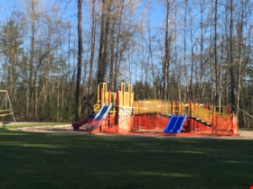
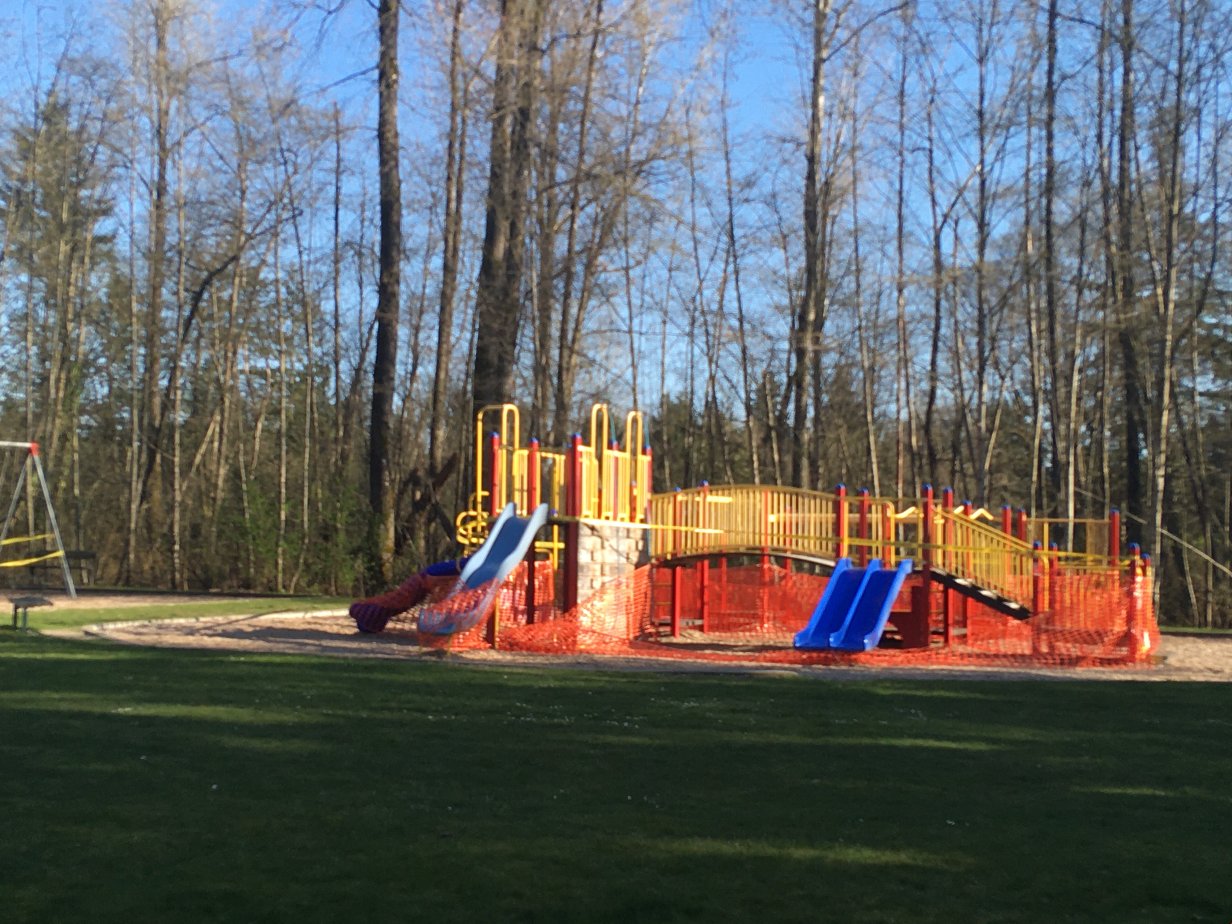
Playground in Squint Lake Park
https://search.heritageburnaby.ca/link/museumdescription14736
- Repository
- Burnaby Village Museum
- Date
- 9 Apr. 2020
- Collection/Fonds
- Burnaby Village Museum COVID-19 collection
- Description Level
- Item
- Physical Description
- 1 photograph (jpg) : col. ; 72 dpi.
- Scope and Content
- Photograph of the Squint Lake Park playground. The playground equipment is surrounded by orange construction fencing to prevent childlren from playing on it. The playground was closed down by the City of Burnaby in the spring of 2020 due to the COVID-19 pandemic and public health orders.
- Repository
- Burnaby Village Museum
- Collection/Fonds
- Burnaby Village Museum COVID-19 collection
- Description Level
- Item
- Physical Description
- 1 photograph (jpg) : col. ; 72 dpi.
- Scope and Content
- Photograph of the Squint Lake Park playground. The playground equipment is surrounded by orange construction fencing to prevent childlren from playing on it. The playground was closed down by the City of Burnaby in the spring of 2020 due to the COVID-19 pandemic and public health orders.
- History
- Tristan Johnson took photos around Burnaby because as a parent of two elementary school aged children during the COVID-19 pandemic, one of the most notable things about COVID-19 during Spring 2020 was the closure of playgrounds and the playgrounds being taped up.
- Accession Code
- BV020.21.1
- Access Restriction
- No restrictions
- Reproduction Restriction
- No known restrictions
- Date
- 9 Apr. 2020
- Media Type
- Photograph
- Planning Study Area
- Sperling-Broadway Area
- Photographer
- Johnson, Tristan
- Notes
- Title based on contents of photograph
Images
![Sperling Avenue School staff members, [1960 or 1961] thumbnail](/media/hpo/_Data/_Archives_Images/_Unrestricted/371/463-014.jpg?width=280)
Sperling Avenue School staff members
https://search.heritageburnaby.ca/link/archivedescription38576
- Repository
- City of Burnaby Archives
- Date
- [1960 or 1961]
- Collection/Fonds
- Burnaby Historical Society fonds
- Description Level
- Item
- Physical Description
- 1 photograph : b&w ; 12.5 x 17.5 cm
- Scope and Content
- Photograph of the fourteen staff members of Sperling Avenue School in the school gymnasium. All are unidentified. A sign in front of the group reads: "Sperling Ave. Elem. Staff 1960-1961."
- Repository
- City of Burnaby Archives
- Date
- [1960 or 1961]
- Collection/Fonds
- Burnaby Historical Society fonds
- Subseries
- Photographs subseries
- Physical Description
- 1 photograph : b&w ; 12.5 x 17.5 cm
- Description Level
- Item
- Record No.
- 463-014
- Access Restriction
- No restrictions
- Reproduction Restriction
- Reproduce for fair dealing purposes only
- Accession Number
- BHS2007-04
- Scope and Content
- Photograph of the fourteen staff members of Sperling Avenue School in the school gymnasium. All are unidentified. A sign in front of the group reads: "Sperling Ave. Elem. Staff 1960-1961."
- Subjects
- Occupations - Teachers
- Names
- Sperling Avenue School
- Media Type
- Photograph
- Notes
- Title based on contents of photograph.
- Geographic Access
- Sperling Avenue
- Street Address
- 2200 Sperling Avenue
- Historic Neighbourhood
- Lochdale (Historic Neighbourhood)
- Planning Study Area
- Sperling-Broadway Area
Images
![Sperling Avenue School staff members, [1960 or 1961] thumbnail](/media/hpo/_Data/_Archives_Images/_Unrestricted/371/463-014.jpg)