Narrow Results By
Subject
- Advertising Medium - Signs and Signboards 3
- Buildings - Civic - Hospitals 1
- Buildings - Residential - Houses 2
- Documentary Artifacts - Portraits 1
- Geographic Features - Automobile Parking Lots 1
- Geographic Features - Inlets 1
- Geographic Features - Mountains 1
- Holidays - Christmas 1
- Organizations - Boys' Societies and Clubs 1
- Pandemics - COVID-19 1
- Persons - Volunteers 1
- Recreational Activities - Golf 1

Burnaby hospital closes main entrance
https://search.heritageburnaby.ca/link/archivedescription95094
- Repository
- City of Burnaby Archives
- Date
- April 6, 2020
- Collection/Fonds
- Burnaby Photographic Society fonds
- Description Level
- Item
- Physical Description
- 1 photograph (tiff)
- Scope and Content
- Photograph of a rerouting sign posted to a sandwich board outside the Burnaby Hospital emergency lot. The sign states that the hospital entrance is closed and requests visitors use the Main Entrance of the hospital.
- Repository
- City of Burnaby Archives
- Date
- April 6, 2020
- Collection/Fonds
- Burnaby Photographic Society fonds
- Physical Description
- 1 photograph (tiff)
- Description Level
- Item
- Record No.
- 623-013
- Access Restriction
- No restrictions
- Reproduction Restriction
- No restrictions
- Accession Number
- 2020-10
- Scope and Content
- Photograph of a rerouting sign posted to a sandwich board outside the Burnaby Hospital emergency lot. The sign states that the hospital entrance is closed and requests visitors use the Main Entrance of the hospital.
- Subjects
- Buildings - Civic - Hospitals
- Geographic Features - Automobile Parking Lots
- Advertising Medium - Signs and Signboards
- Media Type
- Photograph
- Photographer
- Damer, Eric
- Notes
- Transcribed title
- Geographic Access
- Kincaid Street
- Street Address
- 3935 Kincaid Street
- Historic Neighbourhood
- Broadview (Historic Neighbourhood)
- Planning Study Area
- Cascade-Schou Area
Images

Capitol Hill Community Association subseries
https://search.heritageburnaby.ca/link/archivedescription24
- Repository
- City of Burnaby Archives
- Date
- 1943-1955
- Collection/Fonds
- Burnaby Historical Society fonds
- Description Level
- Subseries
- Physical Description
- Textual records and photographs
- Scope and Content
- Subseries consists of a photograph of William Dynes, Capitol Hill Community Hall minute book, and architectural plans for the Association's hall.
- Repository
- City of Burnaby Archives
- Date
- 1943-1955
- Collection/Fonds
- Burnaby Historical Society fonds
- Physical Description
- Textual records and photographs
- Description Level
- Subseries
- Access Restriction
- No restrictions
- Accession Number
- BHS1992-12
- BHS1992-33
- Scope and Content
- Subseries consists of a photograph of William Dynes, Capitol Hill Community Hall minute book, and architectural plans for the Association's hall.
- History
- The Capitol Hall Community Association was formed in 1912, with meetings held in a machine shop located south of Hastings Street. By 1923, the Association had moved to the original Howard Avenue School at Howard and Francis, but the building was destroyed by fire in 1924. A new hall was erected south of Hastings Street in 1926 and was used for Association activities until 1943 when it was also destroyed by fire. From 1943 until late 1947, Capitol Hill Community Association meetings were held in a variety of places, including the United Church Hall, Mrs. Wilson’s house on Ellesmere, Capitol Hill School, Harry Royle’s Store and Mrs. Wood’s house on North Warwick. Various plans and sketches for a new hall were discussed, including one by architect Harold Collerne, but it was turned down. By June of 1944, members decided on the Howard Avenue site on Dynes Park, north of Hastings Street. Two applications for building permits were turned down. In 1946, the Municipal Clerk finally requested tenders for the erection of the hall. In 1947, a "temporary” hall was built on the present site and remains there to this day. Planning and construction was carried out with George Green as Chairman of the Building Committee and William James Dynes as Foreman. The members were in the new hall by December 1947.
- Media Type
- Textual Record
- Photograph
- Notes
- Title based on contents of subseries
- PC282, MSS077

COVID-19 signage outside of Burnaby Mountain Golf Course
https://search.heritageburnaby.ca/link/museumdescription15359
- Repository
- Burnaby Village Museum
- Date
- 6 May 2020
- Collection/Fonds
- Burnaby Village Museum COVID-19 collection
- Description Level
- Item
- Physical Description
- 1 photograph (jpg)
- Scope and Content
- Photograph of COVID-19 signage outside of the Burnaby Mountain Golf Course and Driving Range. Sandwhich board sign reads: "Check In / Attention Golfers / We request that all golfers / stay in the parking lot area / until 15 minutes prior to their tea time".
- Repository
- Burnaby Village Museum
- Collection/Fonds
- Burnaby Village Museum COVID-19 collection
- Description Level
- Item
- Physical Description
- 1 photograph (jpg)
- Scope and Content
- Photograph of COVID-19 signage outside of the Burnaby Mountain Golf Course and Driving Range. Sandwhich board sign reads: "Check In / Attention Golfers / We request that all golfers / stay in the parking lot area / until 15 minutes prior to their tea time".
- Subjects
- Advertising Medium - Signs and Signboards
- Recreational Activities - Golf
- Pandemics - COVID-19
- Geographic Access
- Halifax Street
- Street Address
- 7600 Halifax Street
- Accession Code
- BV021.2.21
- Access Restriction
- No restrictions
- Reproduction Restriction
- May be restricted by third party rights
- Date
- 6 May 2020
- Media Type
- Photograph
- Historic Neighbourhood
- Lochdale (Historic Neighbourhood)
- Planning Study Area
- Sperling-Broadway Area
- Notes
- Title based on contents of photograph
Images


Looking northwest along Dominion Street from near Douglas Road
https://search.heritageburnaby.ca/link/archivedescription91846
- Repository
- City of Burnaby Archives
- Date
- April 2015
- Collection/Fonds
- Small family fonds
- Description Level
- Item
- Physical Description
- 1 photograph : col. copy print ; 10 cm x 15 cm
- Scope and Content
- Photograph of Dominion Street, looking northwest from near Douglas Road. The house at 3093 Douglas Road is just visible between the trees. In 2009 Dominion Street was repaved and sidewalks were installed following a local improvement request to the City.
- Repository
- City of Burnaby Archives
- Date
- April 2015
- Collection/Fonds
- Small family fonds
- Physical Description
- 1 photograph : col. copy print ; 10 cm x 15 cm
- Description Level
- Item
- Record No.
- 620-027
- Access Restriction
- No restrictions
- Reproduction Restriction
- No reproduction permitted
- Accession Number
- 2017-01
- Scope and Content
- Photograph of Dominion Street, looking northwest from near Douglas Road. The house at 3093 Douglas Road is just visible between the trees. In 2009 Dominion Street was repaved and sidewalks were installed following a local improvement request to the City.
- Subjects
- Buildings - Residential - Houses
- Media Type
- Photograph
- Notes
- Transcribed title
- Note in blue ink on verso of photograph reads: "P.27"
- Note in blue ink on verso of photograph reads: "April 2015 / Looking Northwest along Dominion St. from near Douglas Rd."
- Street Address
- 3093 Douglas Road
- Historic Neighbourhood
- Burnaby Lake (Historic Neighbourhood)
- Planning Study Area
- Ardingley-Sprott Area
Images


Looking west along Dominion Street from across the street from 5496 Dominion Street
https://search.heritageburnaby.ca/link/archivedescription91874
- Repository
- City of Burnaby Archives
- Date
- July 2016
- Collection/Fonds
- Small family fonds
- Description Level
- Item
- Physical Description
- 1 photograph : col. copy print ; 10 cm x 15 cm
- Scope and Content
- Photograph of the houses along the south side of Dominion Street with cars parked along the curb. In 2009 sidewalks were installed and the street was repaved under a neighbourhood local improvement request to the City. The photograph was taken from the north side of the street, opposite 5496 Dom…
- Repository
- City of Burnaby Archives
- Date
- July 2016
- Collection/Fonds
- Small family fonds
- Physical Description
- 1 photograph : col. copy print ; 10 cm x 15 cm
- Description Level
- Item
- Record No.
- 620-055
- Access Restriction
- No restrictions
- Reproduction Restriction
- No reproduction permitted
- Accession Number
- 2017-01
- Scope and Content
- Photograph of the houses along the south side of Dominion Street with cars parked along the curb. In 2009 sidewalks were installed and the street was repaved under a neighbourhood local improvement request to the City. The photograph was taken from the north side of the street, opposite 5496 Dominion Street, looking west.
- Media Type
- Photograph
- Notes
- Transcribed title
- Title transcribed from donor's notes
- Note in blue ink on verso of photograph reads: "P.17"
- Note in blue ink on verso of photograph reads: "Dominion St. infilled with houses on 33' lots / Photo July 2016"
- Geographic Access
- Dominion Street
- Historic Neighbourhood
- Burnaby Lake (Historic Neighbourhood)
- Planning Study Area
- Ardingley-Sprott Area
Images

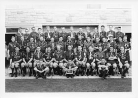
Queen Scout ceremony photographs
https://search.heritageburnaby.ca/link/archivedescription55152
- Repository
- City of Burnaby Archives
- Date
- 1961-1980
- Collection/Fonds
- Burnaby Historical Society fonds
- Description Level
- File
- Physical Description
- 25 photographs : b&w ; 25 cm x 20 cm and smaller
- Scope and Content
- Photographs of the Queen Scout award ceremony and series of Scout troop group portraits.
- Repository
- City of Burnaby Archives
- Date
- 1961-1980
- Collection/Fonds
- Burnaby Historical Society fonds
- Subseries
- Burnaby Scouts subseries
- Physical Description
- 25 photographs : b&w ; 25 cm x 20 cm and smaller
- Description Level
- File
- Record No.
- 631-034
- Access Restriction
- No restrictions
- Reproduction Restriction
- Reproduce for fair dealing purposes only
- Accession Number
- BHS1994-05
- Scope and Content
- Photographs of the Queen Scout award ceremony and series of Scout troop group portraits.
- Names
- Boy Scouts of Canada
- Media Type
- Photograph
- Photographer
- Gibson, Wilfred
- Notes
- Transcribed title
- Title transcribed from envelope in which photographs were originally housed
- Photographer's stamp on verso of all photographs in file: "Gibson's Studio Photographers 819 Broughton St. Victoria, B.C."
- Note in blue ink on recto of 631-034-14 reads: "Reversed as for your [illegible] (new"). Note in blue ink on verso reads: "As you can see - everything is reversed. Whoever said the original prints were printed wrong are wrong themselves. Will Gilin" Note in pencil on verso reads: "Troop #3".
- Note in blue ink on recto of 631-034-15 reads: "New one." Note in blue ink on verso reads: "As per your request this print is reversed. As you can see every-thing is backward. Will Gilin." Note in pencil on verso reads: "Troop #1".
- Note in pencil on verso of 631-034-23 reads: "Scotish Jamoree 75-80?". Notes on verso in pencil and ink identify individuals in photograph: Fred Otte, Gary Otte, Roger Gallaway, Dennis Moore, Jan [illegible], Barkley Ellsworth, Louis MacKinnon, Nigel Tennesan, Ron Murdoch, Fred Smith, Craig Smith, JOhn Steeves, and Wayne Vogan.
Images

Riverway West School Parent-Teachers Association subseries
https://search.heritageburnaby.ca/link/archivedescription110
- Repository
- City of Burnaby Archives
- Date
- 1923-1967
- Collection/Fonds
- Burnaby Historical Society fonds
- Description Level
- Subseries
- Physical Description
- 1 scrapbook.
- Scope and Content
- Subseries consists of a Riverway West School PTA scrapbook and photographs.
- Repository
- City of Burnaby Archives
- Date
- 1923-1967
- Collection/Fonds
- Burnaby Historical Society fonds
- Physical Description
- 1 scrapbook.
- Description Level
- Subseries
- Accession Number
- BHS1992-03
- Scope and Content
- Subseries consists of a Riverway West School PTA scrapbook and photographs.
- History
- The original Riverway West School was a one room school house built in 1923 just west of the ravine at Sussex Avenue and Marine Drive. Miss Marion Swanson was the first teacher at the school ande Mr. Morrison its first custodian. Miss Carrie Kidd taught from 1924 to 1935, with the enrolment increasing from 18 in 1924 to 42 pupils in 1929, and including grades one to seven. In 1930 grades one to four were at Riverway while the older students went to Nelson. It continued on as a one-room school of four grades until 1952. As the school was seen by parents to be “greatly lacking” for students and teachers “in comfortable accommodations and vital equipment necessary for their extra curricular and recreational needs, such as were enjoyed by children in the larger schools” they formed a parent-teacher association in September 1951 to remedy the situation. From the beginning the PTA was very active in making its desires known to the School Board and “the school was very fortunate to have an organisation which put forth such a united effort on behalf of the children”. Their first bazaar fundraiser allowed the PTA to purchase a hot plate and the necessary utensils to provide the students with soup and cocoa during the cold weather. At their request, the School Board improved the electrical wiring in the school and built a roof over the stairs to the basement and provided more sports equipment for the children. Art classes and piano classes were started through the efforts of the members and in 1953 a cub pack and a brownie pack with PTA members as Cub Leaders and Brownie Leaders was created. A ditto machine and school library were the direct results of successful bazaars held by the PTA. The PTA also made a survey of the school district in 1951 to analyse the future school population and presented the results to the School Board. Following this, a portable unit was erected beside the existing school house for use the following September. It was in use until 1958. In the late 1950s, the PTA approached the School Board and the Burnaby Parks and Recreation Commission and proposed a park on the grounds adjacent to their school to relieve a playfield deficiency. The creation of Riverway West Park was the direct result of this proposal. As Parks Planner Paul Stocksted pointed out in 1961, “All of this would not have been possible had not the people associated with the PTA insisted on the solution to the problem of inadequate play areas.” In 1957 the first unit of the new Riverway West School underwent construction. Designed by Carlberg and Jackson with Remigio Maniaga as the contractor, it was completed in September of 1957 and consisted of four classrooms, an activity room and administration facilities. A two classroom addition, also designed by Carlberg and Jackson. was completed on the last day of 1959, three months after its construction began.
- Media Type
- Textual Record
- Photograph
- Notes
- PC273, MSS068
- Title based on creator and contents of subseries
Sheila Minni fonds
https://search.heritageburnaby.ca/link/archivedescription58376
- Repository
- City of Burnaby Archives
- Date
- [1955-1956]
- Collection/Fonds
- Sheila Minni fonds
- Description Level
- Fonds
- Physical Description
- 3 photographs : sepia ; 4.5 x 7 cm.
- Scope and Content
- Fonds consist of photographs showing St. Helen's Church in Burnaby Heights.
- Repository
- City of Burnaby Archives
- Date
- [1955-1956]
- Collection/Fonds
- Sheila Minni fonds
- Physical Description
- 3 photographs : sepia ; 4.5 x 7 cm.
- Description Level
- Fonds
- Access Restriction
- No restrictions
- Reproduction Restriction
- No known restrictions
- Accession Number
- 2009-04
- Scope and Content
- Fonds consist of photographs showing St. Helen's Church in Burnaby Heights.
- History
- In the first years of the 20th century, the hill overlooking the city of Vancouver was barely developed. This area, known as Vancouver Heights, commands a magnificent view of the city, the north shore mountains, and the sea. During the first decade, there was just a handful of people willing to brave the inconvenience of living in a remote area to dwell in such splendour. Among them were 10 Catholic families. They dreamt about establishing a Catholic community, a church, and perhaps even a school of their own. They knew it would take hard work and sacrifice to realize their dream. In 1912, the Second Narrows Bridge and several industrial plants were built in this area. Archbishop Neil McNeil, recognizing the potential for greater development, requested aid from Toronto's Catholic Extension Society, to help purchase property at the corner of Pandora and Ingleton to build a small church and home for the priest. The $6000 construction expense was donated by Mr. Justice Kelly, who requested that the church be named Saint Helen in memory of his daughter, Helen. On August 11, 1912, Saint Helen's church was blessed. 12 years later, in 1923, a second dream was realized with the construction of Saint Helen's School. The Sisters of Charity of Saint Vincent de Paul would staff the school for over 50 years, dedicating their lives to the education of thousands of children. 1936 began an era of unprecedented growth under the leadership of Msgr. Daniel Carey. In 1948, despite post-war hardships, he was able to inspire his community to build a new school. He then turned his attention to the over-crowded church and, in 1956, to the delight of the parishioners, the new Saint Helen's Church was blessed. By 1973, the demographics of Saint Helen's Parish had experienced a dramatic change. From the Anglo-Irish parishioners of the early years, Saint Helen's was experiencing a huge increase in parishioners of Italian descent. Archbishop James Carney, realizing the need to better serve these immigrants, asked the Scalabrinian Congregation to take the parish under its care. The second era of physical growth and development in the parish would come under the direction of these missionary priests. The 1970s, with Father Joseph Ponti as pastor, would see the construction of a new rectory, a state-of-the-art hall/gymnasium, and a fully renovated school. Father Joe's dream was the construction of a church, with this in mind, he began to purchase the necessary land. Succeeding pastors Father Angelo Calandra and Father Peter Sordi continued to work towards this dream, accumulating land and initiating the process. Father Claudio Holzer, upon assuming the responsibilities of pastor, took a firm hold of the dreams of his predecessors and shaped them into the reality of the new Saint Helen's Church. From the beginning, St. Helen's Parish has been an active community participant in this area of Burnaby and continues to enjoy this participation not only here but in Metro Vancouver as well. On August 11, 2012, St. Helen's Catholic Church and Parish celebrated its 100th anniversary. -Information contributed by M. Tesan has been combined with information from the official website of the church.
- Media Type
- Photograph
- Creator
- Minni, Sheila
- Notes
- Title based on contents of fonds.
- Photo catalogue 495
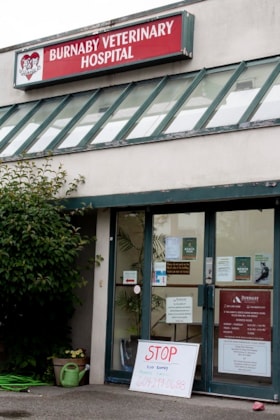
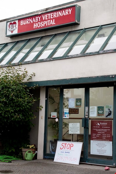
Vet Hospital
https://search.heritageburnaby.ca/link/archivedescription95086
- Repository
- City of Burnaby Archives
- Date
- June 13, 2020
- Collection/Fonds
- Burnaby Photographic Society fonds
- Description Level
- Item
- Physical Description
- 1 photograph (tiff)
- Scope and Content
- Photograph of the exterior of the Burnaby Veterinarian Hospital. A whiteboard is propped up against the door of the hospital with a notice prohibiting visitors from entering and requesting they call for entry.
- Repository
- City of Burnaby Archives
- Date
- June 13, 2020
- Collection/Fonds
- Burnaby Photographic Society fonds
- Physical Description
- 1 photograph (tiff)
- Description Level
- Item
- Record No.
- 623-005
- Access Restriction
- No restrictions
- Reproduction Restriction
- No restrictions
- Accession Number
- 2020-10
- Scope and Content
- Photograph of the exterior of the Burnaby Veterinarian Hospital. A whiteboard is propped up against the door of the hospital with a notice prohibiting visitors from entering and requesting they call for entry.
- Media Type
- Photograph
- Photographer
- Gervan, Bonnie
- Notes
- Transcribed title
- Photographer's caption: "Sign says “Stop, No Entry, Please Call”. Staff will come out to accept the non human clients outside and bring them in for their appointment."
- Geographic Access
- Springer Avenue
- Street Address
- 2210 Springer Avenue
- Planning Study Area
- Ardingley-Sprott Area
Images

View from Kask's Camp
https://search.heritageburnaby.ca/link/archivedescription35531
- Repository
- City of Burnaby Archives
- Date
- 1950 (date of original), copied 1986
- Collection/Fonds
- Burnaby Historical Society fonds
- Description Level
- Item
- Physical Description
- 1 photograph : b&w ; 12.7 x 17.8 cm print
- Scope and Content
- Photograph of top of the hill moved by William Kask, Sr. at the request of Jenny Korhonen Kask who wanted a better view of Burrard Inlet and the islands from her house in Kask's Camp, later Kask Bros. Cement Works. Mr. Kask had the top of the mountain shave off with a bulldozer. A Vancouver Sun h…
- Repository
- City of Burnaby Archives
- Date
- 1950 (date of original), copied 1986
- Collection/Fonds
- Burnaby Historical Society fonds
- Subseries
- Pioneer Tales subseries
- Physical Description
- 1 photograph : b&w ; 12.7 x 17.8 cm print
- Description Level
- Item
- Record No.
- 204-389
- Access Restriction
- No restrictions
- Reproduction Restriction
- Reproduce for fair dealing purposes only
- Accession Number
- BHS1988-03
- Scope and Content
- Photograph of top of the hill moved by William Kask, Sr. at the request of Jenny Korhonen Kask who wanted a better view of Burrard Inlet and the islands from her house in Kask's Camp, later Kask Bros. Cement Works. Mr. Kask had the top of the mountain shave off with a bulldozer. A Vancouver Sun headline read, "Man Moves Mountain."
- Media Type
- Photograph
- Notes
- Title based on contents of photograph
- Geographic Access
- Barnet Road
- Street Address
- 7501 Barnet Road
- Historic Neighbourhood
- Barnet (Historic Neighbourhood)
- Planning Study Area
- Burnaby Mountain Area
Images

![Volunteers at Gizeh Shriners Temple, [2002] thumbnail](/media/hpo/_Data/_Archives_Images/_Unrestricted/535/535-3051-1.jpg?width=280)
Volunteers at Gizeh Shriners Temple
https://search.heritageburnaby.ca/link/archivedescription97799
- Repository
- City of Burnaby Archives
- Date
- [2002]
- Collection/Fonds
- Burnaby NewsLeader photograph collection
- Description Level
- File
- Physical Description
- 6 photographs (tiff) : col.
- Scope and Content
- File contains photographs of volunteers assembling Christmas gift bags for seniors at the Gizeh Shrine Temple in Burnaby. Photographs depict Jaimi Sinclair, Rosie Sesito, Judy Jahner, and Joan Harding making the gift bags and other unidentified volunteers delivering and reviewing donated items.
- Repository
- City of Burnaby Archives
- Date
- [2002]
- Collection/Fonds
- Burnaby NewsLeader photograph collection
- Physical Description
- 6 photographs (tiff) : col.
- Description Level
- File
- Record No.
- 535-3051
- Access Restriction
- No restrictions
- Reproduction Restriction
- No restrictions
- Accession Number
- 2018-12
- Scope and Content
- File contains photographs of volunteers assembling Christmas gift bags for seniors at the Gizeh Shrine Temple in Burnaby. Photographs depict Jaimi Sinclair, Rosie Sesito, Judy Jahner, and Joan Harding making the gift bags and other unidentified volunteers delivering and reviewing donated items.
- Subjects
- Persons - Volunteers
- Holidays - Christmas
- Names
- Gizeh Shrine Temple
- Media Type
- Photograph
- Photographer
- Bartel, Mario
- Notes
- Title based on caption
- Collected by editorial for use in a December 2002 issue of the Burnaby NewsLeader
- Caption from metadata for 535-3051-1: "Jaimi Sinclair sorts through some of the gift bags."
- Caption from metadata for 535-3051-2: "Another load of donated items arrives at the sorting centre, at Burnaby's Gizeh Shrine Temple."
- Caption from metadata for 535-3051-3: "Jaimi Sinclair discusses one of the request lists with a pair of volunteers."
- Caption from metadata for 535-3051-4: "Rosie Sestito and Judy Jahner compile one of the gift packs they've been assigned."
- Caption from metadata for 535-3051-5: "While many of the items in the gift bags are practical, like clothes and toiletries, there's also room for treats."
- Caption from metadata for 535-3051-6: "Joan Harding does a final check on some of the gift bags, before they're ready for distribution to a local seniors' home."
- Geographic Access
- Wayburne Drive
- Street Address
- 3550 Wayburne Drive
- Planning Study Area
- Douglas-Gilpin Area
Images
![Volunteers at Gizeh Shriners Temple, [2002] thumbnail](/media/hpo/_Data/_Archives_Images/_Unrestricted/535/535-3051-1.jpg)