Narrow Results By
Subject
- Agriculture - Crops 2
- Agriculture - Farms 1
- Agriculture - Fruit and Berries 5
- Animals - Bears 1
- Animals - Birds 2
- Animals - Deer 1
- Building Components 1
- Buildings - Agricultural 2
- Buildings - Agricultural - Greenhouses 2
- Buildings - Civic - Art Galleries 1
- Buildings - Commercial - General Stores 1
- Buildings - Heritage 2
Person / Organization
- Bobic, Janice 1
- Borstal School 1
- Bossort, Kathy 8
- Bradbury, Dr. Bettina 2
- Brainerd, Roy 2
- British Columbia Electric Railway Company 5
- Burnaby Art Gallery 1
- Burnaby Mountain Centennial Park 1
- Burnaby Mountain Conservation Area 3
- Burnaby Mountain Park 1
- Burnaby Mountain Preservation Society 6
- Burnaby Village Museum 1

1982 - Moving the Roberts House
https://search.heritageburnaby.ca/link/archivedescription91880
- Repository
- City of Burnaby Archives
- Date
- 1982
- Collection/Fonds
- Small family fonds
- Description Level
- Item
- Physical Description
- 1 photograph : col. copy print ; 10 cm x 15 cm
- Scope and Content
- Photograph of the land being cleared at 5496 Dominion Street in order to create a path to move the Roberts' house onto the property. Included in the clearing are the stumps of two apples trees, a poplar tree, and a maple tree. The debris from the site was burned and smoke can seen rising from a s…
- Repository
- City of Burnaby Archives
- Date
- 1982
- Collection/Fonds
- Small family fonds
- Physical Description
- 1 photograph : col. copy print ; 10 cm x 15 cm
- Description Level
- Item
- Record No.
- 620-061
- Access Restriction
- No restrictions
- Reproduction Restriction
- No reproduction permitted
- Accession Number
- 2017-01
- Scope and Content
- Photograph of the land being cleared at 5496 Dominion Street in order to create a path to move the Roberts' house onto the property. Included in the clearing are the stumps of two apples trees, a poplar tree, and a maple tree. The debris from the site was burned and smoke can seen rising from a small pile of brush on the right.
- Media Type
- Photograph
- Notes
- Transcribed title
- Title transcribed from donor's notes
- Note in blue ink on verso of photograph reads: "p.3"
- Note in pencil on verso of photograph reads: "2"
- Street Address
- 5496 Dominion Street
- Historic Neighbourhood
- Burnaby Lake (Historic Neighbourhood)
- Planning Study Area
- Ardingley-Sprott Area
Images


1982 - Moving the Roberts House 5538 Dominion Street to its new location at 5496 Dominion Street
https://search.heritageburnaby.ca/link/archivedescription91879
- Repository
- City of Burnaby Archives
- Date
- 1982
- Collection/Fonds
- Small family fonds
- Description Level
- Item
- Physical Description
- 1 photograph : col. ; 9 cm x 13 cm
- Scope and Content
- Photograph of the site at 5496 Dominion Street where the Roberts' house was to be moved. To the left is the old garage that was originally part of the small dwelling the Roberts lived in during the construction of their house in the early 1920s. In the background is 3093 Douglas Road and in the f…
- Repository
- City of Burnaby Archives
- Date
- 1982
- Collection/Fonds
- Small family fonds
- Physical Description
- 1 photograph : col. ; 9 cm x 13 cm
- Description Level
- Item
- Record No.
- 620-060
- Access Restriction
- No restrictions
- Reproduction Restriction
- No reproduction permitted
- Accession Number
- 2017-01
- Scope and Content
- Photograph of the site at 5496 Dominion Street where the Roberts' house was to be moved. To the left is the old garage that was originally part of the small dwelling the Roberts lived in during the construction of their house in the early 1920s. In the background is 3093 Douglas Road and in the foreground are two apple trees planted by John W. Roberts.
- Media Type
- Photograph
- Notes
- Transcribed title
- Title transcribed from donor's notes
- Note in blue ink on verso of photograph reads: "p.2"
- Note in blue ink on verso of photograph reads: "Garage, Poplar Tree and Apple Trees before they had to go to make room to move house here / Spring 1982"
- 5118 Douglas Road renumbered to 3131 Douglas Road in 1958 and to 5538 Dominion Street in 1970 or 1971
- Street Address
- 5496 Dominion Street
- Historic Neighbourhood
- Burnaby Lake (Historic Neighbourhood)
- Planning Study Area
- Ardingley-Sprott Area
Images


6742 Walker Avenue
https://search.heritageburnaby.ca/link/archivedescription37844
- Repository
- City of Burnaby Archives
- Date
- May 1987 (date of original), copied 1991
- Collection/Fonds
- Burnaby Historical Society fonds
- Description Level
- Item
- Physical Description
- 1 photograph : b&w ; 3.1 x 4.3 cm print on contact sheet 20.6 x 26.7 cm
- Scope and Content
- Photograph of 6742 Walker Avenue, with only the trees in the yard visible from the road. A van is parked in front.
- Repository
- City of Burnaby Archives
- Date
- May 1987 (date of original), copied 1991
- Collection/Fonds
- Burnaby Historical Society fonds
- Subseries
- Burnaby Image Bank subseries
- Physical Description
- 1 photograph : b&w ; 3.1 x 4.3 cm print on contact sheet 20.6 x 26.7 cm
- Description Level
- Item
- Record No.
- 370-432
- Access Restriction
- No restrictions
- Reproduction Restriction
- No restrictions
- Accession Number
- BHS1999-03
- Scope and Content
- Photograph of 6742 Walker Avenue, with only the trees in the yard visible from the road. A van is parked in front.
- Subjects
- Plants - Trees
- Media Type
- Photograph
- Notes
- Title based on contents of photograph
- 1 b&w copy negative accompanying
- Negative has a pink cast
- Copied from col. photograph
- Geographic Access
- Walker Avenue
- Street Address
- 6742 Walker Avenue
- Historic Neighbourhood
- Edmonds (Historic Neighbourhood)
- Planning Study Area
- Richmond Park Area
Images


6742 Walker Avenue
https://search.heritageburnaby.ca/link/archivedescription37845
- Repository
- City of Burnaby Archives
- Date
- May 1987 (date of original), copied 1991
- Collection/Fonds
- Burnaby Historical Society fonds
- Description Level
- Item
- Physical Description
- 1 photograph : b&w ; 3.0 x 4.4 cm print on contact sheet 20.6 x 26.7 cm
- Scope and Content
- Photograph of 6742 Walker Avenue with some of the trees in the yard cut down.
- Repository
- City of Burnaby Archives
- Date
- May 1987 (date of original), copied 1991
- Collection/Fonds
- Burnaby Historical Society fonds
- Subseries
- Burnaby Image Bank subseries
- Physical Description
- 1 photograph : b&w ; 3.0 x 4.4 cm print on contact sheet 20.6 x 26.7 cm
- Description Level
- Item
- Record No.
- 370-433
- Access Restriction
- No restrictions
- Reproduction Restriction
- No restrictions
- Accession Number
- BHS1999-03
- Scope and Content
- Photograph of 6742 Walker Avenue with some of the trees in the yard cut down.
- Subjects
- Plants - Trees
- Media Type
- Photograph
- Notes
- Title based on contents of photograph
- 1 b&w copy negative accompanying
- Negative has a pink cast
- Copied from col. photograph
- Geographic Access
- Walker Avenue
- Street Address
- 6742 Walker Avenue
- Historic Neighbourhood
- Edmonds (Historic Neighbourhood)
- Planning Study Area
- Richmond Park Area
Images


6742 Walker Avenue
https://search.heritageburnaby.ca/link/archivedescription37846
- Repository
- City of Burnaby Archives
- Date
- May 1987 (date of original), copied 1991
- Collection/Fonds
- Burnaby Historical Society fonds
- Description Level
- Item
- Physical Description
- 1 photograph : b&w ; 3.0 x 4.3 cm print on contact sheet 20.6 x 26.7 cm
- Scope and Content
- Photograph of 6742 Walker Avenue, showing the stumps of the recently cut down trees in the yard of the house.
- Repository
- City of Burnaby Archives
- Date
- May 1987 (date of original), copied 1991
- Collection/Fonds
- Burnaby Historical Society fonds
- Subseries
- Burnaby Image Bank subseries
- Physical Description
- 1 photograph : b&w ; 3.0 x 4.3 cm print on contact sheet 20.6 x 26.7 cm
- Description Level
- Item
- Record No.
- 370-434
- Access Restriction
- No restrictions
- Reproduction Restriction
- No restrictions
- Accession Number
- BHS1999-03
- Scope and Content
- Photograph of 6742 Walker Avenue, showing the stumps of the recently cut down trees in the yard of the house.
- Media Type
- Photograph
- Notes
- Title based on contents of photograph
- 1 b&w copy negative accompanying
- Negative has a pink cast
- Copied from col. photograph
- Geographic Access
- Walker Avenue
- Street Address
- 6742 Walker Avenue
- Historic Neighbourhood
- Edmonds (Historic Neighbourhood)
- Planning Study Area
- Richmond Park Area
Images

![Agricultural Exhibit, [1909] thumbnail](/media/hpo/_Data/_Archives_Images/_Unrestricted/001/041-001.jpg?width=280)
Agricultural Exhibit
https://search.heritageburnaby.ca/link/archivedescription34530
- Repository
- City of Burnaby Archives
- Date
- [1909]
- Collection/Fonds
- Burnaby Historical Society fonds
- Description Level
- Item
- Physical Description
- 1 photograph : b&w ; 20.4 x 25.2 cm
- Scope and Content
- Photograph of Burnaby's Agricultural Exhibit at New Westminster showing a display of vegetables, fruit, flowers, plants, and trees inside of a building.
- Repository
- City of Burnaby Archives
- Date
- [1909]
- Collection/Fonds
- Burnaby Historical Society fonds
- Subseries
- Photographs subseries
- Physical Description
- 1 photograph : b&w ; 20.4 x 25.2 cm
- Description Level
- Item
- Record No.
- 041-001
- Access Restriction
- No restrictions
- Reproduction Restriction
- No known restrictions
- Accession Number
- BHS2007-04
- Scope and Content
- Photograph of Burnaby's Agricultural Exhibit at New Westminster showing a display of vegetables, fruit, flowers, plants, and trees inside of a building.
- Subjects
- Agriculture - Crops
- Exhibitions - Agricultural
- Agriculture - Fruit and Berries
- Plants - Flowers
- Media Type
- Photograph
- Notes
- Title based on contents of photograph
Images
![Agricultural Exhibit, [1909] thumbnail](/media/hpo/_Data/_Archives_Images/_Unrestricted/001/041-001.jpg)
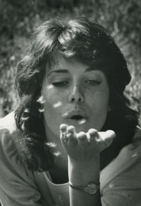
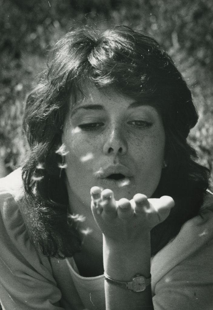
A Woman blowing a dandelion
https://search.heritageburnaby.ca/link/archivedescription58928
- Repository
- City of Burnaby Archives
- Date
- ca.1983
- Collection/Fonds
- Columbian Newspaper collection
- Description Level
- Item
- Physical Description
- 1 photograph : b&w ; 24 x 17.5 cm
- Scope and Content
- Photograph of an unidentified woman blowing dandelion seeds from her outstretched hand.
- Repository
- City of Burnaby Archives
- Date
- ca.1983
- Collection/Fonds
- Columbian Newspaper collection
- Physical Description
- 1 photograph : b&w ; 24 x 17.5 cm
- Description Level
- Item
- Record No.
- 480-1378
- Access Restriction
- No restrictions
- Reproduction Restriction
- May be restricted by third party rights
- Accession Number
- 2009-01
- Scope and Content
- Photograph of an unidentified woman blowing dandelion seeds from her outstretched hand.
- Subjects
- Plants
- Media Type
- Photograph
- Photographer
- Battistoni, Peter
- Notes
- Title based on contents of photograph
- Photographer's stamp on verso
- Note on verso reads: "PMT 100% / page A-2 / Burnaby / Today"
Images

Barnet Neighbourhood
https://search.heritageburnaby.ca/link/landmark747
- Repository
- Burnaby Heritage Planning
- Associated Dates
- 1905-1924
- Heritage Value
- The original Barnet mill burned down in 1909 after a dramatic explosion in the boiler house. The company rebuilt a new plant, considered a model of mill construction. The company's timber was towed down the Pacific in huge rafts containing about 400,000 to 500,000 board feet. Mill capacity during a 10-hour day was 150,000 board feet with an amazing annual output of 50 million feet.
- Historic Neighbourhood
- Barnet (Historic Neighbourhood)
- Planning Study Area
- Burnaby Mountain Area
Images

B.C. Hydro - Burrard Thermal Generating Plant, Ioco, B.C. Air Emissions Permit VA - 330 Renewal
https://search.heritageburnaby.ca/link/councilreport13316
- Repository
- City of Burnaby Archives
- Report ID
- 9112
- Meeting Date
- 12-Dec-1988
- Format
- Council - Manager's Report
- Manager's Report No.
- 77
- Item No.
- 4
- Collection/Fonds
- City Council and Office of the City Clerk fonds
- Repository
- City of Burnaby Archives
- Report ID
- 9112
- Meeting Date
- 12-Dec-1988
- Format
- Council - Manager's Report
- Manager's Report No.
- 77
- Item No.
- 4
- Collection/Fonds
- City Council and Office of the City Clerk fonds
Documents
Boundary Road Improvements - Relocation of BC Tel Overhead Plant
https://search.heritageburnaby.ca/link/councilreport19477
- Repository
- City of Burnaby Archives
- Report ID
- 1530
- Meeting Date
- 17-Nov-1980
- Format
- Council - Manager's Report
- Manager's Report No.
- 70
- Item No.
- 7
- Collection/Fonds
- City Council and Office of the City Clerk fonds
- Repository
- City of Burnaby Archives
- Report ID
- 1530
- Meeting Date
- 17-Nov-1980
- Format
- Council - Manager's Report
- Manager's Report No.
- 70
- Item No.
- 7
- Collection/Fonds
- City Council and Office of the City Clerk fonds
Documents

Brentwood Neighbourhood
https://search.heritageburnaby.ca/link/landmark780
- Repository
- Burnaby Heritage Planning
- Associated Dates
- 1955-2008
- Heritage Value
- Between 1955 and 2001, the Brentwood Neighbourhood developed into one of Burnaby's four official Town Centres. The Brentwood Town Centre serves the north-west sector of the Municipality, providing facilities such as commercial developments - of which the Brentwood Mall is the most significant. Under Burnaby's Residential Development Framework adopted by Council in 1981, the Town Centre also incorporated a full range of multi-housing types and forms in close relationship with their commercial facilities. In 1996, the City adopted the Brentwood Town Centre Development Plant to solidify the area as a focus of higher-density and higher-intensity residential and commercial opportunities, public transit and supporting leisure facilities.
- Planning Study Area
- Brentwood Area
Images

![Brunette River, [1907] thumbnail](/media/hpo/_Data/_Archives_Images/_Unrestricted/126/133-005.jpg?width=280)
Brunette River
https://search.heritageburnaby.ca/link/archivedescription34774
- Repository
- City of Burnaby Archives
- Date
- [1907]
- Collection/Fonds
- Burnaby Historical Society fonds
- Description Level
- Item
- Physical Description
- 1 photograph : sepia ; 12.6 x 17.5 cm
- Scope and Content
- Photograph of the Brunette River.
- Repository
- City of Burnaby Archives
- Date
- [1907]
- Collection/Fonds
- Burnaby Historical Society fonds
- Subseries
- Gerald Davy subseries
- Physical Description
- 1 photograph : sepia ; 12.6 x 17.5 cm
- Description Level
- Item
- Record No.
- 133-005
- Access Restriction
- No restrictions
- Reproduction Restriction
- No known restrictions
- Accession Number
- BHS1985-01
- Scope and Content
- Photograph of the Brunette River.
- Media Type
- Photograph
- Photographer
- Davy, Gerald
- Notes
- Title based on contents of photograph
- Geographic Access
- Brunette River
- Planning Study Area
- Burnaby Lake Area
- Cariboo-Armstrong Area
Images
![Brunette River, [1907] thumbnail](/media/hpo/_Data/_Archives_Images/_Unrestricted/126/133-005.jpg)
![Brunette River, 1907] thumbnail](/media/hpo/_Data/_Archives_Images/_Unrestricted/126/133-008.jpg?width=280)
Brunette River
https://search.heritageburnaby.ca/link/archivedescription34777
- Repository
- City of Burnaby Archives
- Date
- 1907]
- Collection/Fonds
- Burnaby Historical Society fonds
- Description Level
- Item
- Physical Description
- 1 photograph : sepia ; 10.1 x 12.6 cm
- Scope and Content
- Photograph of the Brunette River.
- Repository
- City of Burnaby Archives
- Date
- 1907]
- Collection/Fonds
- Burnaby Historical Society fonds
- Subseries
- Gerald Davy subseries
- Physical Description
- 1 photograph : sepia ; 10.1 x 12.6 cm
- Description Level
- Item
- Record No.
- 133-008
- Access Restriction
- No restrictions
- Reproduction Restriction
- No known restrictions
- Accession Number
- BHS1985-01
- Scope and Content
- Photograph of the Brunette River.
- Media Type
- Photograph
- Photographer
- Davy, Gerald
- Notes
- Title based on contents of photograph
- Geographic Access
- Brunette River
- Planning Study Area
- Burnaby Lake Area
- Cariboo-Armstrong Area
Images
![Brunette River, 1907] thumbnail](/media/hpo/_Data/_Archives_Images/_Unrestricted/126/133-008.jpg)
![Brunette River, [1907] thumbnail](/media/hpo/_Data/_Archives_Images/_Unrestricted/126/133-011.jpg?width=280)
Brunette River
https://search.heritageburnaby.ca/link/archivedescription34780
- Repository
- City of Burnaby Archives
- Date
- [1907]
- Collection/Fonds
- Burnaby Historical Society fonds
- Description Level
- Item
- Physical Description
- 1 photograph : b&w ; 10.0 x 12.6 cm
- Scope and Content
- Photograph of the Brunette River.
- Repository
- City of Burnaby Archives
- Date
- [1907]
- Collection/Fonds
- Burnaby Historical Society fonds
- Subseries
- Gerald Davy subseries
- Physical Description
- 1 photograph : b&w ; 10.0 x 12.6 cm
- Description Level
- Item
- Record No.
- 133-011
- Access Restriction
- No restrictions
- Reproduction Restriction
- No known restrictions
- Accession Number
- BHS1985-01
- Scope and Content
- Photograph of the Brunette River.
- Media Type
- Photograph
- Photographer
- Davy, Gerald
- Notes
- Title based on contents of photograph
- Geographic Access
- Brunette River
- Planning Study Area
- Burnaby Lake Area
- Cariboo-Armstrong Area
Images
![Brunette River, [1907] thumbnail](/media/hpo/_Data/_Archives_Images/_Unrestricted/126/133-011.jpg)
![Brunette River, [1907] thumbnail](/media/hpo/_Data/_Archives_Images/_Unrestricted/126/133-013.jpg?width=280)
Brunette River
https://search.heritageburnaby.ca/link/archivedescription34782
- Repository
- City of Burnaby Archives
- Date
- [1907]
- Collection/Fonds
- Burnaby Historical Society fonds
- Description Level
- Item
- Physical Description
- 1 photograph : b&w ; 10.0 x 12.6 cm
- Scope and Content
- Photograph of the Brunette River.
- Repository
- City of Burnaby Archives
- Date
- [1907]
- Collection/Fonds
- Burnaby Historical Society fonds
- Subseries
- Gerald Davy subseries
- Physical Description
- 1 photograph : b&w ; 10.0 x 12.6 cm
- Description Level
- Item
- Record No.
- 133-013
- Access Restriction
- No restrictions
- Reproduction Restriction
- No known restrictions
- Accession Number
- BHS1985-01
- Scope and Content
- Photograph of the Brunette River.
- Media Type
- Photograph
- Photographer
- Davy, Gerald
- Notes
- Title based on contents of photograph
- Geographic Access
- Brunette River
- Planning Study Area
- Burnaby Lake Area
- Cariboo-Armstrong Area
Images
![Brunette River, [1907] thumbnail](/media/hpo/_Data/_Archives_Images/_Unrestricted/126/133-013.jpg)
![Brunette River in the winter, [1907] thumbnail](/media/hpo/_Data/_Archives_Images/_Unrestricted/126/133-007.jpg?width=280)
Brunette River in the winter
https://search.heritageburnaby.ca/link/archivedescription34776
- Repository
- City of Burnaby Archives
- Date
- [1907]
- Collection/Fonds
- Burnaby Historical Society fonds
- Description Level
- Item
- Physical Description
- 1 photograph : sepia ; 9.6 x 11.8 cm
- Scope and Content
- Photograph of the Brunette River in the winter.
- Repository
- City of Burnaby Archives
- Date
- [1907]
- Collection/Fonds
- Burnaby Historical Society fonds
- Subseries
- Gerald Davy subseries
- Physical Description
- 1 photograph : sepia ; 9.6 x 11.8 cm
- Description Level
- Item
- Record No.
- 133-007
- Access Restriction
- No restrictions
- Reproduction Restriction
- No known restrictions
- Accession Number
- BHS1985-01
- Scope and Content
- Photograph of the Brunette River in the winter.
- Media Type
- Photograph
- Photographer
- Davy, Gerald
- Notes
- Title based on contents of photograph
- Stamped on back of photograph: "Rotograph D."
- Geographic Access
- Brunette River
- Planning Study Area
- Burnaby Lake Area
- Cariboo-Armstrong Area
Images
![Brunette River in the winter, [1907] thumbnail](/media/hpo/_Data/_Archives_Images/_Unrestricted/126/133-007.jpg)
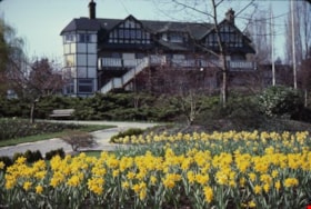
Burnaby Art Gallery daffodil gardens
https://search.heritageburnaby.ca/link/archivedescription36277
- Repository
- City of Burnaby Archives
- Date
- April 1983
- Collection/Fonds
- Burnaby Historical Society fonds
- Description Level
- Item
- Physical Description
- 1 photograph : col. slide ; 2.5 x 3.5 cm
- Scope and Content
- Photograph of the back of the Burnaby Art Gallery and its daffodil gardens.
- Repository
- City of Burnaby Archives
- Date
- April 1983
- Collection/Fonds
- Burnaby Historical Society fonds
- Subseries
- Burnaby Art Gallery subseries
- Physical Description
- 1 photograph : col. slide ; 2.5 x 3.5 cm
- Description Level
- Item
- Record No.
- 242-027
- Access Restriction
- No restrictions
- Reproduction Restriction
- Reproduce for fair dealing purposes only
- Accession Number
- BHS1990-05
- Scope and Content
- Photograph of the back of the Burnaby Art Gallery and its daffodil gardens.
- Names
- Burnaby Art Gallery
- Media Type
- Photograph
- Notes
- Title based on contents of photograph
- Geographic Access
- Deer Lake Avenue
- Street Address
- 6344 Deer Lake Avenue
- Historic Neighbourhood
- Burnaby Lake (Historic Neighbourhood)
- Planning Study Area
- Douglas-Gilpin Area
Images


Burnaby Lake
https://search.heritageburnaby.ca/link/archivedescription91701
- Repository
- City of Burnaby Archives
- Date
- March 1982 - April 1982
- Collection/Fonds
- Doreen Lawson fonds
- Description Level
- File
- Physical Description
- 17 photographs : col. slides ; 35 mm
- Scope and Content
- File consists photographs of Burnaby Lake taken in late winter. The foliage around the lake is primarily brown and wilted with the first new growth of Spring just emerging. Canadian geese swim on the lake in the foreground of several of the photographs, with snow-covered mountains and the Loughee…
- Repository
- City of Burnaby Archives
- Date
- March 1982 - April 1982
- Collection/Fonds
- Doreen Lawson fonds
- Physical Description
- 17 photographs : col. slides ; 35 mm
- Description Level
- File
- Record No.
- 618-019
- Access Restriction
- No restrictions
- Reproduction Restriction
- No restrictions
- Accession Number
- 2015-15
- Scope and Content
- File consists photographs of Burnaby Lake taken in late winter. The foliage around the lake is primarily brown and wilted with the first new growth of Spring just emerging. Canadian geese swim on the lake in the foreground of several of the photographs, with snow-covered mountains and the Lougheed Mall skyline visible in the distance. Also included in the file is one photograph of the forest alongside the Brunette River.
- Media Type
- Photograph
- Photographer
- Lawson, Doreen A.
- Notes
- Transcribed title
- Title transcribed from label on slide sheets photographs originally housed in
- Geographic Access
- Burnaby Lake
- Brunette River
- Historic Neighbourhood
- Burnaby Lake (Historic Neighbourhood)
- Planning Study Area
- Burnaby Lake Area
Images

Burnaby Refuse Incineration Plant
https://search.heritageburnaby.ca/link/councilreport13053
- Repository
- City of Burnaby Archives
- Report ID
- 7616
- Meeting Date
- 28-Mar-1989
- Format
- Council - Manager's Report
- Manager's Report No.
- 24
- Item No.
- 11
- Collection/Fonds
- City Council and Office of the City Clerk fonds
- Repository
- City of Burnaby Archives
- Report ID
- 7616
- Meeting Date
- 28-Mar-1989
- Format
- Council - Manager's Report
- Manager's Report No.
- 24
- Item No.
- 11
- Collection/Fonds
- City Council and Office of the City Clerk fonds
Documents
![Burnaby Substation, [September 1907] thumbnail](/media/hpo/_Data/_Archives_Images/_Unrestricted/251/293-002.jpg?width=280)
Burnaby Substation
https://search.heritageburnaby.ca/link/archivedescription36541
- Repository
- City of Burnaby Archives
- Date
- [September 1907]
- Collection/Fonds
- Burnaby Historical Society fonds
- Description Level
- Item
- Physical Description
- 1 photograph : b&w postcard ; 7.5 x 13 cm
- Scope and Content
- Photographic postcard of the British Columbia Electric Railway Company's Burnaby Substation that was built in 1903 and put into operation to receive and distribute power from the B.C.E.R. Buntzen Lake power dam. The electric lines came across the inlet at Barnet, along the Barnet-Hastings Road to S…
- Repository
- City of Burnaby Archives
- Date
- [September 1907]
- Collection/Fonds
- Burnaby Historical Society fonds
- Subseries
- John DeForest subseries
- Physical Description
- 1 photograph : b&w postcard ; 7.5 x 13 cm
- Description Level
- Item
- Record No.
- 293-002
- Access Restriction
- No restrictions
- Reproduction Restriction
- No known restrictions
- Accession Number
- BHS1992-30
- Scope and Content
- Photographic postcard of the British Columbia Electric Railway Company's Burnaby Substation that was built in 1903 and put into operation to receive and distribute power from the B.C.E.R. Buntzen Lake power dam. The electric lines came across the inlet at Barnet, along the Barnet-Hastings Road to Sperling Avenue (built for this project and called Pole Line Road) and then south to this site at the corner of Griffiths and the old Central Park interurban line (later this section was called the Highland Park line). This substation was constructed to convert the alternating current being delivered from the Buntzen power plant to direct current for the operation of the tram cars operating on the Central Park interurban route. The new brick substation replaced the wood fed steam powered 1891 Powerhouse that operated south of this site, across the tracks until its closure on May 31,1905. It was demolised in the late 1920s. This brick substation originally known as the Burnaby Substation, eventually became known as the Newell Substation. The original brick building was replaced by a new structure in 1930, which was demolished in the 1960s in favour of the open field substation that continues to operate on the same site today at 7260 Griffiths Avenue.
- Subjects
- Buildings - Industrial - Powerhouses
- Media Type
- Photograph
- Notes
- Title based on contents of photograph
- Geographic Access
- Griffiths Avenue
- Historic Neighbourhood
- Edmonds (Historic Neighbourhood)
- Planning Study Area
- Stride Avenue Area
Images
![Burnaby Substation, [September 1907] thumbnail](/media/hpo/_Data/_Archives_Images/_Unrestricted/251/293-002.jpg)