Narrow Results By
Subject
- Aerial Photographs 1
- Agriculture 1
- Agriculture - Farms 2
- Agriculture - Fruit and Berries 3
- Buildings - Agricultural 1
- Buildings - Heritage 1
- Buildings - Industrial 1
- Buildings - Industrial - Factories 3
- Buildings - Industrial - Mills 1
- Buildings - Residential - Houses 3
- Documentary Artifacts - Portraits 1
- Events - Parades 2
Creator
- Associated Factory Mutual Fire Insurance Cos 1
- Brainerd family 1
- Cash, Jack 1
- City of Burnaby 1
- Commercial Illustrators Industrial Photographers 1
- Digney, Andy 1
- Eagles, Dr. Blythe 1
- Eagles, Dr. Violet 1
- Ehlers, Edith "Edie" Fleming 1
- Ettinger, James Gilmore 1
- Fleming, Frances "Fanny" Waplington 1
- Hemmins, H. 1
Operation of a Metal Fabrication Plant at 2042 Griffiths Avenue
https://search.heritageburnaby.ca/link/councilreport43471
- Repository
- City of Burnaby Archives
- Report ID
- 43861
- Meeting Date
- 17-Dec-1956
- Format
- Council - Mayor/Councillor/Staff Report
- Collection/Fonds
- City Council and Office of the City Clerk fonds
- Repository
- City of Burnaby Archives
- Report ID
- 43861
- Meeting Date
- 17-Dec-1956
- Format
- Council - Mayor/Councillor/Staff Report
- Collection/Fonds
- City Council and Office of the City Clerk fonds
Documents
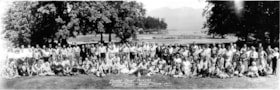
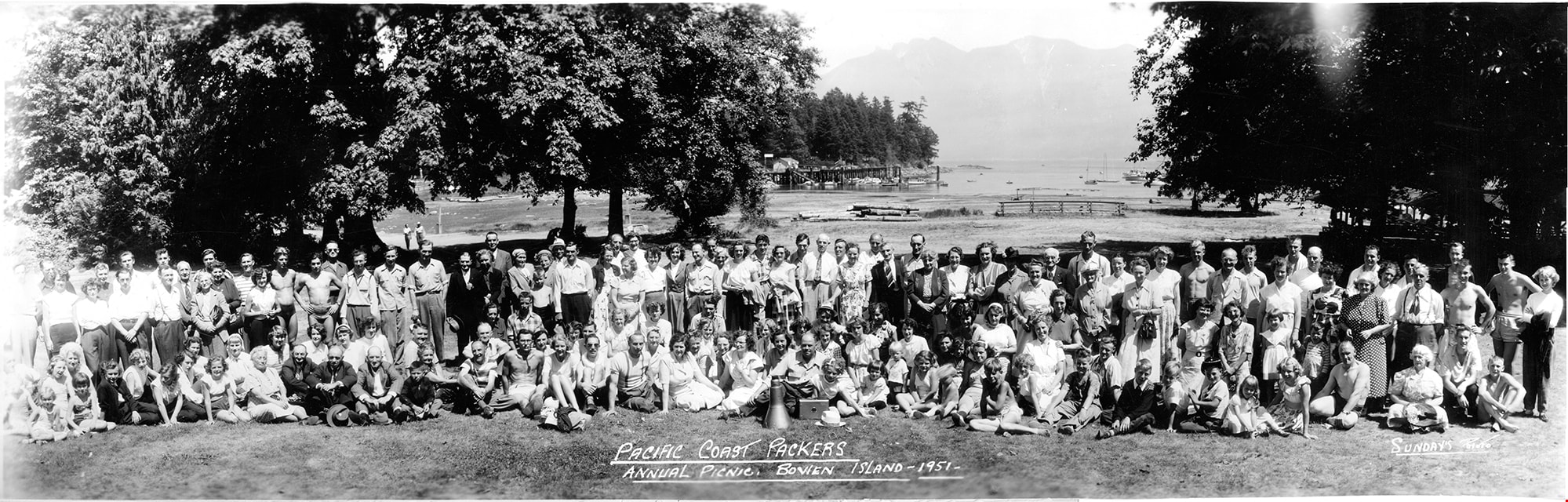
Pacific Coast Packers annual picnic
https://search.heritageburnaby.ca/link/museumdescription18880
- Repository
- Burnaby Village Museum
- Date
- 1951
- Collection/Fonds
- Burnaby Village Museum Photograph collection
- Description Level
- Item
- Physical Description
- 1 photograph : b&w ; 18.5 x 57.5 cm
- Scope and Content
- Photograph of a large group of staff members from the Pacific Coast Packers and their families gathered together for a group photograph at their annual summer picnic on Bowen Island. Employees identified include; John Dubois, company receiver and truck driver (very back row fourth from left); compa…
- Repository
- Burnaby Village Museum
- Collection/Fonds
- Burnaby Village Museum Photograph collection
- Description Level
- Item
- Physical Description
- 1 photograph : b&w ; 18.5 x 57.5 cm
- Scope and Content
- Photograph of a large group of staff members from the Pacific Coast Packers and their families gathered together for a group photograph at their annual summer picnic on Bowen Island. Employees identified include; John Dubois, company receiver and truck driver (very back row fourth from left); company accountant, Jeanie Robertson Turner (standing in third row in front of John Dubois); Harry Gelhorn who worked in plant maintenance (seated in front row, 6th from left) and Frank Taylor who was in charge of quality control and was the chief jam maker (seated in front row, 4th from right). Pacific Coast Packers Limited was a fruit and vegetable cannery located on 2100 MacPherson Avenue in Burnaby.
- Subjects
- Recreational Activities - Picnics
- Names
- Pacific Coast Packers
- Turner, Jean Robertson "Jeanie"
- Dubois, John
- Gelhorn, Harry
- Taylor, Frank
- Accession Code
- BV022.25.1
- Access Restriction
- No restrictions
- Reproduction Restriction
- No known restrictions
- Date
- 1951
- Media Type
- Photograph
- Scan Resolution
- 600
- Scan Date
- 2022-09-28
- Photographer
- Sunday, Fred William
- Notes
- Title based on contents of photograph
- Title in white script on recto of photograph below group reads: "PACIFIC COAST PACKERS / ANNUAL PICNIC, BOWEN ISLAND-1951 / SUNDAY'S PHOTO"
Images
![Parade float, [195-] (date of original), copied 1992 thumbnail](/media/hpo/_Data/_Archives_Images/_Unrestricted/315/315-058.jpg?width=280)
Parade float
https://search.heritageburnaby.ca/link/archivedescription36703
- Repository
- City of Burnaby Archives
- Date
- [195-] (date of original), copied 1992
- Collection/Fonds
- Burnaby Historical Society fonds
- Description Level
- Item
- Physical Description
- 1 photograph : b&w ; 8.7 x 12.6 cm print
- Scope and Content
- Photograph of a parade float decorated with flowers, including "Burnaby" written along the side.
- Repository
- City of Burnaby Archives
- Date
- [195-] (date of original), copied 1992
- Collection/Fonds
- Burnaby Historical Society fonds
- Subseries
- Burnaby Centennial Anthology subseries
- Physical Description
- 1 photograph : b&w ; 8.7 x 12.6 cm print
- Description Level
- Item
- Record No.
- 315-058
- Access Restriction
- No restrictions
- Reproduction Restriction
- Reproduce for fair dealing purposes only
- Accession Number
- BHS1994-04
- Scope and Content
- Photograph of a parade float decorated with flowers, including "Burnaby" written along the side.
- Media Type
- Photograph
- Notes
- Title based on contents of photograph
Images
![Parade float, [195-] (date of original), copied 1992 thumbnail](/media/hpo/_Data/_Archives_Images/_Unrestricted/315/315-058.jpg)

Parade on Kingsway
https://search.heritageburnaby.ca/link/archivedescription38169
- Repository
- City of Burnaby Archives
- Date
- 1958 (date of original), copied 1991
- Collection/Fonds
- Burnaby Historical Society fonds
- Description Level
- Item
- Physical Description
- 1 photograph : b&w ; 3.8 x 3.8 cm print on contact sheet 20.1 x 26.3 cm
- Scope and Content
- Photograph of a parade on the 4600 block of Kingsway. The photograph was taken looking south, and the Ford Motor Co. plant can be seen in the background.
- Repository
- City of Burnaby Archives
- Date
- 1958 (date of original), copied 1991
- Collection/Fonds
- Burnaby Historical Society fonds
- Subseries
- Burnaby Image Bank subseries
- Physical Description
- 1 photograph : b&w ; 3.8 x 3.8 cm print on contact sheet 20.1 x 26.3 cm
- Description Level
- Item
- Record No.
- 370-756
- Access Restriction
- No restrictions
- Reproduction Restriction
- No restrictions
- Accession Number
- BHS1999-03
- Scope and Content
- Photograph of a parade on the 4600 block of Kingsway. The photograph was taken looking south, and the Ford Motor Co. plant can be seen in the background.
- Names
- Ford Motor Company
- Media Type
- Photograph
- Notes
- Title based on contents of photograph
- 1 b&w copy negative accompanying
- Copy negative has a pink cast
- Geographic Access
- Kingsway
- Historic Neighbourhood
- Central Park (Historic Neighbourhood)
- Planning Study Area
- Maywood Area
Images

Parade on Kingsway
https://search.heritageburnaby.ca/link/archivedescription38173
- Repository
- City of Burnaby Archives
- Date
- 1958 (date of original), copied 1991
- Collection/Fonds
- Burnaby Historical Society fonds
- Description Level
- Item
- Physical Description
- 1 photograph : b&w ; 3.8 x 3.7 cm print on contact sheet 20.6 x 26.5 cm
- Scope and Content
- Photograph of parade on the 4600 block of Kingsway showing four women on the road. The photo was taken looking south, and a vacant lot at Sussex Avenue and Kingsway can be seen in the background. The Ford Motor Co. plant can be seen at the back right.
- Repository
- City of Burnaby Archives
- Date
- 1958 (date of original), copied 1991
- Collection/Fonds
- Burnaby Historical Society fonds
- Subseries
- Burnaby Image Bank subseries
- Physical Description
- 1 photograph : b&w ; 3.8 x 3.7 cm print on contact sheet 20.6 x 26.5 cm
- Description Level
- Item
- Record No.
- 370-760
- Access Restriction
- No restrictions
- Reproduction Restriction
- No restrictions
- Accession Number
- BHS1999-03
- Scope and Content
- Photograph of parade on the 4600 block of Kingsway showing four women on the road. The photo was taken looking south, and a vacant lot at Sussex Avenue and Kingsway can be seen in the background. The Ford Motor Co. plant can be seen at the back right.
- Subjects
- Events - Parades
- Names
- Ford Motor Company
- Media Type
- Photograph
- Notes
- Title based on contents of photograph
- 1 b&w copy negative accompanying
- Negative has a pink cast
- Date at top of photograph reads. "Aug 58"
- Geographic Access
- Kingsway
- Historic Neighbourhood
- Central Park (Historic Neighbourhood)
- Planning Study Area
- Maywood Area
Images

Pat Loynes
https://search.heritageburnaby.ca/link/archivedescription37663
- Repository
- City of Burnaby Archives
- Date
- 1958 (date of original), copied 1991
- Collection/Fonds
- Burnaby Historical Society fonds
- Description Level
- Item
- Physical Description
- 1 photograph : b&w ; 4.5 x 3.0 cm print on contact sheet 20.2 x 25.3 cm
- Scope and Content
- Photograph of Pat Loynes standing at the front of 6131 Silver Avenue in the spring of 1958. The Ford Motor Co. plant can be seen in the background.
- Repository
- City of Burnaby Archives
- Date
- 1958 (date of original), copied 1991
- Collection/Fonds
- Burnaby Historical Society fonds
- Subseries
- Burnaby Image Bank subseries
- Physical Description
- 1 photograph : b&w ; 4.5 x 3.0 cm print on contact sheet 20.2 x 25.3 cm
- Description Level
- Item
- Record No.
- 370-251
- Access Restriction
- No restrictions
- Reproduction Restriction
- No restrictions
- Accession Number
- BHS1999-03
- Scope and Content
- Photograph of Pat Loynes standing at the front of 6131 Silver Avenue in the spring of 1958. The Ford Motor Co. plant can be seen in the background.
- Media Type
- Photograph
- Notes
- Title based on contents of photograph
- 1 b&w copy negative accompanying
- Negative has a pink cast
- Geographic Access
- Silver Avenue
- Street Address
- 6131 Silver Avenue
- Historic Neighbourhood
- Central Park (Historic Neighbourhood)
- Planning Study Area
- Maywood Area
Images

People next to a large fallen tree
https://search.heritageburnaby.ca/link/archivedescription39514
- Repository
- City of Burnaby Archives
- Date
- 1898
- Collection/Fonds
- Peers Family and Hill Family fonds
- Description Level
- Item
- Physical Description
- 1 photograph : sepia ; 9.8 x 13.5 cm on page 21.5 x 28 cm (pasted in album)
- Scope and Content
- Photograph of a group of people next to a very large fallen tree. The photograph was taken just above Deer Lake Avenue and the home of Bernard Hill can be seen in the background. Identified in the picture are Mrs. Sprott (standing in front of tree to the left), directly in front of her, lying on th…
- Repository
- City of Burnaby Archives
- Date
- 1898
- Collection/Fonds
- Peers Family and Hill Family fonds
- Physical Description
- 1 photograph : sepia ; 9.8 x 13.5 cm on page 21.5 x 28 cm (pasted in album)
- Description Level
- Item
- Record No.
- 477-833
- Access Restriction
- No restrictions
- Reproduction Restriction
- No known restrictions
- Accession Number
- 2007-12
- Scope and Content
- Photograph of a group of people next to a very large fallen tree. The photograph was taken just above Deer Lake Avenue and the home of Bernard Hill can be seen in the background. Identified in the picture are Mrs. Sprott (standing in front of tree to the left), directly in front of her, lying on the ground is Bernard Hill. The woman standing farthest to the right (next to man holding child) is Marian Hill and next to her is Claude Hill holding his daughter Kitty. The man farthest to the right is Mr. Sprott. The rest are unidentified.
- Subjects
- Land Clearing
- Plants - Trees
- Names
- Hill, Bernard R.
- Hill, Marian Berkeley
- Hill, Louis Claude "Claude"
- Peers, Katherine Maude Hill "Kitty"
- Media Type
- Photograph
- Notes
- Title based on caption accompanying photograph
- Geographic Access
- Deer Lake Avenue
- Historic Neighbourhood
- Burnaby Lake (Historic Neighbourhood)
- Planning Study Area
- Douglas-Gilpin Area
Images

Physical Plant Plans series
https://search.heritageburnaby.ca/link/archivedescription145
- Repository
- City of Burnaby Archives
- Date
- 1950-2003
- Collection/Fonds
- Engineering Department fonds
- Description Level
- Series
- Scope and Content
- Series consists of architectural drawings and plans created by the Physical Plant Maintenance division of the Engineering Department. This division is responsible for the development of maintenance programs for all civic facilities in Burnaby and these records resulted from that activity.
- Repository
- City of Burnaby Archives
- Date
- 1950-2003
- Collection/Fonds
- Engineering Department fonds
- Series
- Physical Plant Plans series
- Description Level
- Series
- Scope and Content
- Series consists of architectural drawings and plans created by the Physical Plant Maintenance division of the Engineering Department. This division is responsible for the development of maintenance programs for all civic facilities in Burnaby and these records resulted from that activity.
- Media Type
- Textual Record
Planting Stakes on Hastings Road
https://search.heritageburnaby.ca/link/councilreport78908
- Repository
- City of Burnaby Archives
- Report ID
- 82932
- Meeting Date
- 21-Jan-1895
- Format
- Council - Mayor/Councillor/Staff Report
- Collection/Fonds
- City Council and Office of the City Clerk fonds
- Repository
- City of Burnaby Archives
- Report ID
- 82932
- Meeting Date
- 21-Jan-1895
- Format
- Council - Mayor/Councillor/Staff Report
- Collection/Fonds
- City Council and Office of the City Clerk fonds
Documents

Powerhouse
https://search.heritageburnaby.ca/link/landmark731
- Repository
- Burnaby Heritage Planning
- Geographic Access
- Griffiths Avenue
- Kingsway
- Associated Dates
- 1891
- Heritage Value
- Constructed in 1891 between Edmonds and Highland Park on the Central Park Interurban Line, the steam plant provided power to run the line, then operated by Westminster and Vancouver Tramway Company. The steam powerhouse was replaced in 1905 by a B.C. Electric substation which was put into operation to receive and distribute power from the B.C.E.R. Buntzen Lake power dam. Prior to Burnaby having its own Municipal Hall, Council meetings were often held at the boarding house adjacent to the powerhouse and in 1892, Burnaby’s first Council meeting was held at the boarding house in 1892.
- Historic Neighbourhood
- Edmonds (Historic Neighbourhood)
- Planning Study Area
- Kingsway-Beresford Area
Images

![Powerhouse, [189-?] (date of original), copied [196-?] thumbnail](/media/hpo/_Data/_BVM_Images/1976/1976_0145_0002_001.jpg?width=280)
Powerhouse
https://search.heritageburnaby.ca/link/museumdescription831
- Repository
- Burnaby Village Museum
- Date
- [189-?] (date of original), copied [196-?]
- Collection/Fonds
- Burnaby Village Museum Photograph collection
- Description Level
- Item
- Physical Description
- 1 photograph : b&w ; 7.6 x 9.6 cm print
- Scope and Content
- Photograph of a powerhouse with tall smoke stacks, located beside railway tracks. Three trams can be seen on the right side of the photograph and men are standing outside of the building. According to an accompanying note, the powerhouse doubled as a steam plant and a car barn. Constructed in 1891,…
- Repository
- Burnaby Village Museum
- Collection/Fonds
- Burnaby Village Museum Photograph collection
- Description Level
- Item
- Physical Description
- 1 photograph : b&w ; 7.6 x 9.6 cm print
- Scope and Content
- Photograph of a powerhouse with tall smoke stacks, located beside railway tracks. Three trams can be seen on the right side of the photograph and men are standing outside of the building. According to an accompanying note, the powerhouse doubled as a steam plant and a car barn. Constructed in 1891, it was between Edmonds and Highland Park on the Central Park Interurban Line. The steam plant provided power to run the line, then operated by Westminster and Vancouver Tramway Company.
- Subjects
- Transportation - Electric Railroads
- Accession Code
- HV976.145.2
- Access Restriction
- No restrictions
- Reproduction Restriction
- May be restricted by third party rights
- Date
- [189-?] (date of original), copied [196-?]
- Media Type
- Photograph
- Historic Neighbourhood
- Edmonds (Historic Neighbourhood)
- Planning Study Area
- Stride Avenue Area
- Scan Resolution
- 600
- Scan Date
- 2023-06-27
- Notes
- Title based on contents of photograph
Images
![Powerhouse, [189-?] (date of original), copied [196-?] thumbnail](/media/hpo/_Data/_BVM_Images/1976/1976_0145_0002_001.jpg)
Prairie agriculture : containing a list of chemical experiments, a series of experiments on the growth of seeds, a description of how plants grow, a sketch of the formation of the prairie soil by water and ice action, an account of farming operations and of crops adapted to Manitoba, a description of diseases of crops, of insects, and of birds : an account with illustrations of the breeds of horses, cattle, sheep, swine and poultry adapted to Manitoba : advantages of mixed farming
https://search.heritageburnaby.ca/link/museumlibrary175
- Repository
- Burnaby Village Museum
- Collection
- Special Collection
- Material Type
- Book
- Accession Code
- HV971.120.22
- Call Number
- 630 PRA
- Place of Publication
- Winnipeg
- Publisher
- Consolidated Stationery Co.
- Publication Date
- 1890
- Physical Description
- 259 p. : ill. : 19 cm.
- Inscription
- "Maggie E. Patterson Lockerby S.D. Man" [Handwritten in pencil on front endpaper] "Maggie E. Patterson Lockerby School 1898" [Handwritten in black ink on front flyleaf]
- Library Subject (LOC)
- Agriculture
- Manitoba
- Subjects
- Agriculture
Proposal of the Greater Vancouver Water District to Extend a Supply Main to the Shell Oil Company Plant from the Existing Main Albert and Delta
https://search.heritageburnaby.ca/link/councilreport46390
- Repository
- City of Burnaby Archives
- Report ID
- 45655
- Meeting Date
- 9-Mar-1953
- Format
- Council - Committee Report
- Collection/Fonds
- City Council and Office of the City Clerk fonds
- Repository
- City of Burnaby Archives
- Report ID
- 45655
- Meeting Date
- 9-Mar-1953
- Format
- Council - Committee Report
- Collection/Fonds
- City Council and Office of the City Clerk fonds
Documents
Sheila Minni fonds
https://search.heritageburnaby.ca/link/archivedescription58376
- Repository
- City of Burnaby Archives
- Date
- [1955-1956]
- Collection/Fonds
- Sheila Minni fonds
- Description Level
- Fonds
- Physical Description
- 3 photographs : sepia ; 4.5 x 7 cm.
- Scope and Content
- Fonds consist of photographs showing St. Helen's Church in Burnaby Heights.
- Repository
- City of Burnaby Archives
- Date
- [1955-1956]
- Collection/Fonds
- Sheila Minni fonds
- Physical Description
- 3 photographs : sepia ; 4.5 x 7 cm.
- Description Level
- Fonds
- Access Restriction
- No restrictions
- Reproduction Restriction
- No known restrictions
- Accession Number
- 2009-04
- Scope and Content
- Fonds consist of photographs showing St. Helen's Church in Burnaby Heights.
- History
- In the first years of the 20th century, the hill overlooking the city of Vancouver was barely developed. This area, known as Vancouver Heights, commands a magnificent view of the city, the north shore mountains, and the sea. During the first decade, there was just a handful of people willing to brave the inconvenience of living in a remote area to dwell in such splendour. Among them were 10 Catholic families. They dreamt about establishing a Catholic community, a church, and perhaps even a school of their own. They knew it would take hard work and sacrifice to realize their dream. In 1912, the Second Narrows Bridge and several industrial plants were built in this area. Archbishop Neil McNeil, recognizing the potential for greater development, requested aid from Toronto's Catholic Extension Society, to help purchase property at the corner of Pandora and Ingleton to build a small church and home for the priest. The $6000 construction expense was donated by Mr. Justice Kelly, who requested that the church be named Saint Helen in memory of his daughter, Helen. On August 11, 1912, Saint Helen's church was blessed. 12 years later, in 1923, a second dream was realized with the construction of Saint Helen's School. The Sisters of Charity of Saint Vincent de Paul would staff the school for over 50 years, dedicating their lives to the education of thousands of children. 1936 began an era of unprecedented growth under the leadership of Msgr. Daniel Carey. In 1948, despite post-war hardships, he was able to inspire his community to build a new school. He then turned his attention to the over-crowded church and, in 1956, to the delight of the parishioners, the new Saint Helen's Church was blessed. By 1973, the demographics of Saint Helen's Parish had experienced a dramatic change. From the Anglo-Irish parishioners of the early years, Saint Helen's was experiencing a huge increase in parishioners of Italian descent. Archbishop James Carney, realizing the need to better serve these immigrants, asked the Scalabrinian Congregation to take the parish under its care. The second era of physical growth and development in the parish would come under the direction of these missionary priests. The 1970s, with Father Joseph Ponti as pastor, would see the construction of a new rectory, a state-of-the-art hall/gymnasium, and a fully renovated school. Father Joe's dream was the construction of a church, with this in mind, he began to purchase the necessary land. Succeeding pastors Father Angelo Calandra and Father Peter Sordi continued to work towards this dream, accumulating land and initiating the process. Father Claudio Holzer, upon assuming the responsibilities of pastor, took a firm hold of the dreams of his predecessors and shaped them into the reality of the new Saint Helen's Church. From the beginning, St. Helen's Parish has been an active community participant in this area of Burnaby and continues to enjoy this participation not only here but in Metro Vancouver as well. On August 11, 2012, St. Helen's Catholic Church and Parish celebrated its 100th anniversary. -Information contributed by M. Tesan has been combined with information from the official website of the church.
- Media Type
- Photograph
- Creator
- Minni, Sheila
- Notes
- Title based on contents of fonds.
- Photo catalogue 495

Shell Oil Company
https://search.heritageburnaby.ca/link/landmark675
- Repository
- Burnaby Heritage Planning
- Geographic Access
- Kensington Avenue
- Associated Dates
- ca. 1930-1993
- Heritage Value
- After considering several sites in the Greater Vancouver area, the Shell Oil Company chose 70 acres in North Burnaby with frontage of one third of a mile on Burrard Inlet. Shell proposed to build a four-million dollar plant that would employ up to 2000 - providing some relief in the middle of Burnaby's economic crisis of the Depression years. The site became known as the Shellburn Refinery and was in operation until 1993.
- Historic Neighbourhood
- Lochdale (Historic Neighbourhood)
- Planning Study Area
- Westridge Area
Images

![Side view of white house, [between 1940 and 1950] thumbnail](/media/hpo/_Data/_BVM_Images/2007/2007_0020_0023_001.jpg?width=280)
Side view of white house
https://search.heritageburnaby.ca/link/museumdescription4400
- Repository
- Burnaby Village Museum
- Date
- [between 1940 and 1950]
- Collection/Fonds
- Rhoda Jeffers fonds
- Description Level
- Item
- Physical Description
- 1 photograph : sepia ; 9 x 14 cm
- Scope and Content
- Photograph of the side view of a white house. There is a porch with a lattice screened porch at one end. On the side of the house is a bay window. There are plants growing along the side of the house.
- Repository
- Burnaby Village Museum
- Collection/Fonds
- Rhoda Jeffers fonds
- Description Level
- Item
- Physical Description
- 1 photograph : sepia ; 9 x 14 cm
- Scope and Content
- Photograph of the side view of a white house. There is a porch with a lattice screened porch at one end. On the side of the house is a bay window. There are plants growing along the side of the house.
- Accession Code
- BV007.20.23
- Access Restriction
- No restrictions
- Reproduction Restriction
- May be restricted by third party rights
- Date
- [between 1940 and 1950]
- Media Type
- Photograph
- Scan Resolution
- 600
- Scan Date
- 13/05/2018
- Notes
- Title based on content of photograph
- This appears to be the same house at photo BV007.20.22
Images
![Side view of white house, [between 1940 and 1950] thumbnail](/media/hpo/_Data/_BVM_Images/2007/2007_0020_0023_001.jpg)
![Small child sitting on the grass, [between 1940 and 1960] thumbnail](/media/hpo/_Data/_BVM_Images/2007/2007_0020_0013_001.jpg?width=280)
Small child sitting on the grass
https://search.heritageburnaby.ca/link/museumdescription4390
- Repository
- Burnaby Village Museum
- Date
- [between 1940 and 1960]
- Collection/Fonds
- Rhoda Jeffers fonds
- Description Level
- Item
- Physical Description
- 1 photograph : b&w ; 11 x 6.5 cm
- Scope and Content
- Photograph of an unidentified young child sitting on the grass beside a small wheelbarrow. The child is wearing polka dot shorts, a white top and is barefoot. There is a wooden fence behind with some flowering plants along the bottom.
- Repository
- Burnaby Village Museum
- Collection/Fonds
- Rhoda Jeffers fonds
- Description Level
- Item
- Physical Description
- 1 photograph : b&w ; 11 x 6.5 cm
- Scope and Content
- Photograph of an unidentified young child sitting on the grass beside a small wheelbarrow. The child is wearing polka dot shorts, a white top and is barefoot. There is a wooden fence behind with some flowering plants along the bottom.
- Accession Code
- BV007.20.13
- Access Restriction
- No restrictions
- Reproduction Restriction
- May be restricted by third party rights
- Date
- [between 1940 and 1960]
- Media Type
- Photograph
- Scan Resolution
- 600
- Scan Date
- 24/04/2018
- Notes
- Title based on content of photograph
Images
![Small child sitting on the grass, [between 1940 and 1960] thumbnail](/media/hpo/_Data/_BVM_Images/2007/2007_0020_0013_001.jpg)
Small family fonds
https://search.heritageburnaby.ca/link/archivedescription91819
- Repository
- City of Burnaby Archives
- Date
- 1922-2016
- Collection/Fonds
- Small family fonds
- Description Level
- Fonds
- Physical Description
- 75 photographs : b&w & col. + 1 plan
- Scope and Content
- Fonds consists of photographs documenting the transformation of the Burnaby Lake area of Burnaby, B.C. from semi-rural in the 1920s to urbanized in 2016. Photographs depict the land and houses located on the corner of Douglas Road and Dominion Street as the property was rezoned and its density quad…
- Repository
- City of Burnaby Archives
- Date
- 1922-2016
- Collection/Fonds
- Small family fonds
- Physical Description
- 75 photographs : b&w & col. + 1 plan
- Description Level
- Fonds
- Access Restriction
- Open access
- Reproduction Restriction
- May be restricted by third party rights
- Accession Number
- 2017-01
- Scope and Content
- Fonds consists of photographs documenting the transformation of the Burnaby Lake area of Burnaby, B.C. from semi-rural in the 1920s to urbanized in 2016. Photographs depict the land and houses located on the corner of Douglas Road and Dominion Street as the property was rezoned and its density quadrupled. Fonds also includes photographs of the Small family house being moved to 5496 Dominion Street and the original landscape plan for 5118 Douglas Road.
- History
- In 1915, John W. Roberts and his wife Mary Allen Roberts moved from the United States to Canada along with their daughter, Lauretta. On first moving to Canada, the family lived in a rented house in Vancouver and John worked as a movie projectionist in the city. The couple had three more children, all sons: John A., Edward, and Roland. Circa 1921, John purchased a large parcel of land at the corner of Douglas Road and Dominion Street in Burnaby. This parcel encompassed the equivalent of at least six 66-foot lots along the south side of Dominion Street and the same along the north side of Norfolk Street. On their property, a barn and small living quarters were built. The family moved in, raising goats and growing potatoes to supplement their income. They also planted cherry, apple, and pear trees; hazelnut and walnut trees; raspberries; and a large vegetable garden, the fruits of which Mary preserved for year-round use. At this time, agricultural activities were common for families in the area: the Roberts' neighbours kept chickens for personal use and for selling eggs; grew mushrooms for commercial sale; and sold manure from an old buckboard drawn by Clydesdale horses. John built a new house in the middle of the Roberts’ lots on the southwest corner of Douglas Road and Dominion Street. The house faced Douglas Road and overlooked a large, well-landscaped front yard to the east and a full-sized, clay tennis court to the north. The family moved into this new house in 1925. When the Roberts ceased raising goats, the barn and original living quarters were reduced to a double-car garage with storage space plus a sawdust-insulated “root cellar”. John also built a house on the northwest corner of the lot at Douglas Road and Dominion Street (3093 Douglas Road), which was purchased by the Hardy family. In 1957, part of this property (3071 Douglas Road) was sold to the Brocklebanks who built a house and lived there. In addition, John built a house at the northwest corner of Douglas Road and Norfolk Street (5106 Douglas Road). The original purchaser of this house is unknown, but in 1949, it was bought by the Meyers family. In 1952 or 1953, the Meyers sold part of this property and the Manahans built a house on it, facing Douglas Road. Several other lots that John owned were also sold off over the years. By the 1950s, John owned only five 66-foot lots from Douglas Road west, along the south side Dominion Street. In 1954, John sold the lot furthest from Douglas Road (5486 Dominion Street) to a builder who built a “ranch-style” house and put it up for sale. John retired from his career as a movie projectionist in the 1950s. He, Mary, and Lauretta retained their US citizenship all their lives, although they never returned to the USA except for brief visits. John A., Edward, and Roland who, as children of US citizens, also had US citizenship, eventually moved to the US, where they remained for the rest of their lives. In 1945, Lauretta married Frederick Small. The couple lived in a rented house in Vancouver for a few years before moving in with John and Mary in Burnaby. The couple had four children: Elizabeth, Kathryn, Charles, and Martin. In 1955, Frederick purchased the rancher at 5486 Dominion Street and the family moved in. The Small children grew up enjoying the freedom of having their grandparent’s large property in addition to their parent’s yard to play in. The back lane that ran between Dominion Street and Norfolk Street was filled with trees and bushes, creating a narrow bit of “forest” to explore. In 1957, John died. Mary died in 1969, as did Frederick. Lauretta was executor for her mother’s and husband’s estates. After much consideration, she decided to sell the house at 5486 Dominion Street and move back into her childhood home. By doing so, she was able to settle her mother’s estate to the satisfaction of her brothers. Elizabeth married and moved away. Over the next few years, the “Roberts” house was home to Lauretta, Kathryn, Charles, and Martin, with the three grown children moving in and out several times during the 1970s. In 1981, Lauretta died. Her children discussed at length how to divide up the property, which consisted of four 66-foot lots, according to her will. None of her children wanted to see the old family house destroyed but the house straddled two lots. They finally decided that if one of them wanted to pay to move the house to sit on one of the lots, the “value” of the house would not enter into the settlement of the estate. Kathryn chose to do this. In 1982, the old house was moved to 5496 Dominion Street and Kathryn continued to live in it. Martin died in 1982. Elizabeth and Charles each inherited one lot and the last lot, which would have gone to Martin, was sold, the funds divided equally between Elizabeth, Kathryn, and Charles. The three lots between 5496 Dominion Street and Douglas Road were subdivided into 33-foot lots and six new houses were built. In 1993, the Meyers property and the Manahan property were subdivided into 33-foot lots facing Norfolk Street and the old houses were torn down and four new houses were built.
- Media Type
- Photograph
- Technical Drawing
- Creator
- Small family
South Burnaby Garden papers
https://search.heritageburnaby.ca/link/archivedescription57883
- Repository
- City of Burnaby Archives
- Date
- 1950-1961
- Collection/Fonds
- Burnaby Historical Society fonds
- Description Level
- File
- Physical Description
- 1 file of textual records
- Scope and Content
- File contains correspondence pertaining to the South Burnaby Garden Club, as well as information on various plants and fertilizers. Also included in the file is a Fall Show programme from the North Burnaby Horticultural Society.
- Repository
- City of Burnaby Archives
- Date
- 1950-1961
- Collection/Fonds
- Burnaby Historical Society fonds
- Subseries
- South Burnaby Garden Club subseries
- Physical Description
- 1 file of textual records
- Description Level
- File
- Record No.
- MSS028-029
- Accession Number
- BHS1986-36
- Scope and Content
- File contains correspondence pertaining to the South Burnaby Garden Club, as well as information on various plants and fertilizers. Also included in the file is a Fall Show programme from the North Burnaby Horticultural Society.
- Media Type
- Textual Record
- Notes
- Title based on contents of file
![Suey Ying Jung (Laura) lying on grass, [between 1946 and 1955] thumbnail](/media/hpo/_Data/_BVM_Images/2017/2017_0024_0014_001.jpg?width=280)
Suey Ying Jung (Laura) lying on grass
https://search.heritageburnaby.ca/link/museumdescription4061
- Repository
- Burnaby Village Museum
- Date
- [between 1946 and 1955]
- Collection/Fonds
- Julie Lee and Cecil Lee family fonds
- Description Level
- Item
- Physical Description
- 1 photograph (tiff) : sepia ; 1200 dpi
- Scope and Content
- Photograph of Suey Ying Jung (Laura) lying on grass; lattice and plants in background.
- Repository
- Burnaby Village Museum
- Collection/Fonds
- Julie Lee and Cecil Lee family fonds
- Description Level
- Item
- Physical Description
- 1 photograph (tiff) : sepia ; 1200 dpi
- Scope and Content
- Photograph of Suey Ying Jung (Laura) lying on grass; lattice and plants in background.
- Names
- Jung, Suey Ying "Laura"
- Accession Code
- BV017.24.14
- Access Restriction
- No restrictions
- Reproduction Restriction
- No known restrictions
- Date
- [between 1946 and 1955]
- Media Type
- Photograph
- Historic Neighbourhood
- Burnaby Lake (Historic Neighbourhood)
- Planning Study Area
- Douglas-Gilpin Area
- Scan Resolution
- 1200
- Scan Date
- 01-Oct-2017
- Scale
- 100
- Notes
- Title based on contents of photograph
Images
![Suey Ying Jung (Laura) lying on grass, [between 1946 and 1955] thumbnail](/media/hpo/_Data/_BVM_Images/2017/2017_0024_0014_001.jpg)