Narrow Results By
Person / Organization
- Bissett, Bill 1
- Bobic, Janice 2
- Bossort, Kathy 13
- Brainerd, Roy 2
- British Columbia Hydro and Power Authority 1
- Burnaby Art Gallery 1
- Burnaby Lake Park Association 1
- Burnaby Mountain Centennial Park 1
- Burnaby Mountain Centennial Rose Garden 1
- Burnaby Mountain Conservation Area 8
- Burnaby Mountain Park 1
- Burnaby Mountain Preservation Society 7
Removal and Control of Invasive Plants in Selected Locations in Burnaby
https://search.heritageburnaby.ca/link/councilreport57339
- Repository
- City of Burnaby Archives
- Report ID
- 78150
- Meeting Date
- 17-May-2010
- Format
- Council - Committee Report
- Collection/Fonds
- City Council and Office of the City Clerk fonds
- Repository
- City of Burnaby Archives
- Report ID
- 78150
- Meeting Date
- 17-May-2010
- Format
- Council - Committee Report
- Collection/Fonds
- City Council and Office of the City Clerk fonds
Documents

Brentwood Neighbourhood
https://search.heritageburnaby.ca/link/landmark780
- Repository
- Burnaby Heritage Planning
- Associated Dates
- 1955-2008
- Heritage Value
- Between 1955 and 2001, the Brentwood Neighbourhood developed into one of Burnaby's four official Town Centres. The Brentwood Town Centre serves the north-west sector of the Municipality, providing facilities such as commercial developments - of which the Brentwood Mall is the most significant. Under Burnaby's Residential Development Framework adopted by Council in 1981, the Town Centre also incorporated a full range of multi-housing types and forms in close relationship with their commercial facilities. In 1996, the City adopted the Brentwood Town Centre Development Plant to solidify the area as a focus of higher-density and higher-intensity residential and commercial opportunities, public transit and supporting leisure facilities.
- Planning Study Area
- Brentwood Area
Images


Shell Oil Company
https://search.heritageburnaby.ca/link/landmark675
- Repository
- Burnaby Heritage Planning
- Geographic Access
- Kensington Avenue
- Associated Dates
- ca. 1930-1993
- Heritage Value
- After considering several sites in the Greater Vancouver area, the Shell Oil Company chose 70 acres in North Burnaby with frontage of one third of a mile on Burrard Inlet. Shell proposed to build a four-million dollar plant that would employ up to 2000 - providing some relief in the middle of Burnaby's economic crisis of the Depression years. The site became known as the Shellburn Refinery and was in operation until 1993.
- Historic Neighbourhood
- Lochdale (Historic Neighbourhood)
- Planning Study Area
- Westridge Area
Images


1982 - Moving the Roberts House
https://search.heritageburnaby.ca/link/archivedescription91880
- Repository
- City of Burnaby Archives
- Date
- 1982
- Collection/Fonds
- Small family fonds
- Description Level
- Item
- Physical Description
- 1 photograph : col. copy print ; 10 cm x 15 cm
- Scope and Content
- Photograph of the land being cleared at 5496 Dominion Street in order to create a path to move the Roberts' house onto the property. Included in the clearing are the stumps of two apples trees, a poplar tree, and a maple tree. The debris from the site was burned and smoke can seen rising from a s…
- Repository
- City of Burnaby Archives
- Date
- 1982
- Collection/Fonds
- Small family fonds
- Physical Description
- 1 photograph : col. copy print ; 10 cm x 15 cm
- Description Level
- Item
- Record No.
- 620-061
- Access Restriction
- No restrictions
- Reproduction Restriction
- No reproduction permitted
- Accession Number
- 2017-01
- Scope and Content
- Photograph of the land being cleared at 5496 Dominion Street in order to create a path to move the Roberts' house onto the property. Included in the clearing are the stumps of two apples trees, a poplar tree, and a maple tree. The debris from the site was burned and smoke can seen rising from a small pile of brush on the right.
- Media Type
- Photograph
- Notes
- Transcribed title
- Title transcribed from donor's notes
- Note in blue ink on verso of photograph reads: "p.3"
- Note in pencil on verso of photograph reads: "2"
- Street Address
- 5496 Dominion Street
- Historic Neighbourhood
- Burnaby Lake (Historic Neighbourhood)
- Planning Study Area
- Ardingley-Sprott Area
Images


1982 - Moving the Roberts House 5538 Dominion Street to its new location at 5496 Dominion Street
https://search.heritageburnaby.ca/link/archivedescription91879
- Repository
- City of Burnaby Archives
- Date
- 1982
- Collection/Fonds
- Small family fonds
- Description Level
- Item
- Physical Description
- 1 photograph : col. ; 9 cm x 13 cm
- Scope and Content
- Photograph of the site at 5496 Dominion Street where the Roberts' house was to be moved. To the left is the old garage that was originally part of the small dwelling the Roberts lived in during the construction of their house in the early 1920s. In the background is 3093 Douglas Road and in the f…
- Repository
- City of Burnaby Archives
- Date
- 1982
- Collection/Fonds
- Small family fonds
- Physical Description
- 1 photograph : col. ; 9 cm x 13 cm
- Description Level
- Item
- Record No.
- 620-060
- Access Restriction
- No restrictions
- Reproduction Restriction
- No reproduction permitted
- Accession Number
- 2017-01
- Scope and Content
- Photograph of the site at 5496 Dominion Street where the Roberts' house was to be moved. To the left is the old garage that was originally part of the small dwelling the Roberts lived in during the construction of their house in the early 1920s. In the background is 3093 Douglas Road and in the foreground are two apple trees planted by John W. Roberts.
- Media Type
- Photograph
- Notes
- Transcribed title
- Title transcribed from donor's notes
- Note in blue ink on verso of photograph reads: "p.2"
- Note in blue ink on verso of photograph reads: "Garage, Poplar Tree and Apple Trees before they had to go to make room to move house here / Spring 1982"
- 5118 Douglas Road renumbered to 3131 Douglas Road in 1958 and to 5538 Dominion Street in 1970 or 1971
- Street Address
- 5496 Dominion Street
- Historic Neighbourhood
- Burnaby Lake (Historic Neighbourhood)
- Planning Study Area
- Ardingley-Sprott Area
Images


6742 Walker Avenue
https://search.heritageburnaby.ca/link/archivedescription37844
- Repository
- City of Burnaby Archives
- Date
- May 1987 (date of original), copied 1991
- Collection/Fonds
- Burnaby Historical Society fonds
- Description Level
- Item
- Physical Description
- 1 photograph : b&w ; 3.1 x 4.3 cm print on contact sheet 20.6 x 26.7 cm
- Scope and Content
- Photograph of 6742 Walker Avenue, with only the trees in the yard visible from the road. A van is parked in front.
- Repository
- City of Burnaby Archives
- Date
- May 1987 (date of original), copied 1991
- Collection/Fonds
- Burnaby Historical Society fonds
- Subseries
- Burnaby Image Bank subseries
- Physical Description
- 1 photograph : b&w ; 3.1 x 4.3 cm print on contact sheet 20.6 x 26.7 cm
- Description Level
- Item
- Record No.
- 370-432
- Access Restriction
- No restrictions
- Reproduction Restriction
- No restrictions
- Accession Number
- BHS1999-03
- Scope and Content
- Photograph of 6742 Walker Avenue, with only the trees in the yard visible from the road. A van is parked in front.
- Subjects
- Plants - Trees
- Media Type
- Photograph
- Notes
- Title based on contents of photograph
- 1 b&w copy negative accompanying
- Negative has a pink cast
- Copied from col. photograph
- Geographic Access
- Walker Avenue
- Street Address
- 6742 Walker Avenue
- Historic Neighbourhood
- Edmonds (Historic Neighbourhood)
- Planning Study Area
- Richmond Park Area
Images


6742 Walker Avenue
https://search.heritageburnaby.ca/link/archivedescription37845
- Repository
- City of Burnaby Archives
- Date
- May 1987 (date of original), copied 1991
- Collection/Fonds
- Burnaby Historical Society fonds
- Description Level
- Item
- Physical Description
- 1 photograph : b&w ; 3.0 x 4.4 cm print on contact sheet 20.6 x 26.7 cm
- Scope and Content
- Photograph of 6742 Walker Avenue with some of the trees in the yard cut down.
- Repository
- City of Burnaby Archives
- Date
- May 1987 (date of original), copied 1991
- Collection/Fonds
- Burnaby Historical Society fonds
- Subseries
- Burnaby Image Bank subseries
- Physical Description
- 1 photograph : b&w ; 3.0 x 4.4 cm print on contact sheet 20.6 x 26.7 cm
- Description Level
- Item
- Record No.
- 370-433
- Access Restriction
- No restrictions
- Reproduction Restriction
- No restrictions
- Accession Number
- BHS1999-03
- Scope and Content
- Photograph of 6742 Walker Avenue with some of the trees in the yard cut down.
- Subjects
- Plants - Trees
- Media Type
- Photograph
- Notes
- Title based on contents of photograph
- 1 b&w copy negative accompanying
- Negative has a pink cast
- Copied from col. photograph
- Geographic Access
- Walker Avenue
- Street Address
- 6742 Walker Avenue
- Historic Neighbourhood
- Edmonds (Historic Neighbourhood)
- Planning Study Area
- Richmond Park Area
Images


6742 Walker Avenue
https://search.heritageburnaby.ca/link/archivedescription37846
- Repository
- City of Burnaby Archives
- Date
- May 1987 (date of original), copied 1991
- Collection/Fonds
- Burnaby Historical Society fonds
- Description Level
- Item
- Physical Description
- 1 photograph : b&w ; 3.0 x 4.3 cm print on contact sheet 20.6 x 26.7 cm
- Scope and Content
- Photograph of 6742 Walker Avenue, showing the stumps of the recently cut down trees in the yard of the house.
- Repository
- City of Burnaby Archives
- Date
- May 1987 (date of original), copied 1991
- Collection/Fonds
- Burnaby Historical Society fonds
- Subseries
- Burnaby Image Bank subseries
- Physical Description
- 1 photograph : b&w ; 3.0 x 4.3 cm print on contact sheet 20.6 x 26.7 cm
- Description Level
- Item
- Record No.
- 370-434
- Access Restriction
- No restrictions
- Reproduction Restriction
- No restrictions
- Accession Number
- BHS1999-03
- Scope and Content
- Photograph of 6742 Walker Avenue, showing the stumps of the recently cut down trees in the yard of the house.
- Media Type
- Photograph
- Notes
- Title based on contents of photograph
- 1 b&w copy negative accompanying
- Negative has a pink cast
- Copied from col. photograph
- Geographic Access
- Walker Avenue
- Street Address
- 6742 Walker Avenue
- Historic Neighbourhood
- Edmonds (Historic Neighbourhood)
- Planning Study Area
- Richmond Park Area
Images

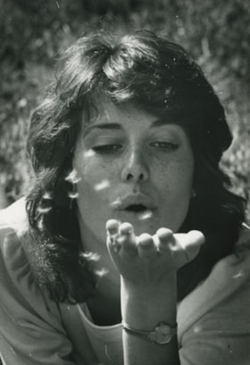
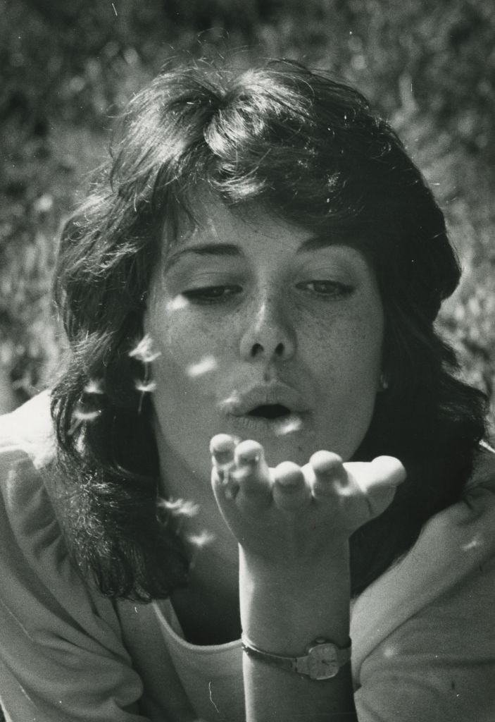
A Woman blowing a dandelion
https://search.heritageburnaby.ca/link/archivedescription58928
- Repository
- City of Burnaby Archives
- Date
- ca.1983
- Collection/Fonds
- Columbian Newspaper collection
- Description Level
- Item
- Physical Description
- 1 photograph : b&w ; 24 x 17.5 cm
- Scope and Content
- Photograph of an unidentified woman blowing dandelion seeds from her outstretched hand.
- Repository
- City of Burnaby Archives
- Date
- ca.1983
- Collection/Fonds
- Columbian Newspaper collection
- Physical Description
- 1 photograph : b&w ; 24 x 17.5 cm
- Description Level
- Item
- Record No.
- 480-1378
- Access Restriction
- No restrictions
- Reproduction Restriction
- Reproduce for fair dealing purposes only
- Accession Number
- 2009-01
- Scope and Content
- Photograph of an unidentified woman blowing dandelion seeds from her outstretched hand.
- Subjects
- Plants
- Media Type
- Photograph
- Photographer
- Battistoni, Peter
- Notes
- Title based on contents of photograph
- Photographer's stamp on verso
- Note on verso reads: "PMT 100% / page A-2 / Burnaby / Today"
Images
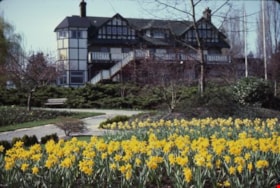
Burnaby Art Gallery daffodil gardens
https://search.heritageburnaby.ca/link/archivedescription36277
- Repository
- City of Burnaby Archives
- Date
- April 1983
- Collection/Fonds
- Burnaby Historical Society fonds
- Description Level
- Item
- Physical Description
- 1 photograph : col. slide ; 2.5 x 3.5 cm
- Scope and Content
- Photograph of the back of the Burnaby Art Gallery and its daffodil gardens.
- Repository
- City of Burnaby Archives
- Date
- April 1983
- Collection/Fonds
- Burnaby Historical Society fonds
- Subseries
- Burnaby Art Gallery subseries
- Physical Description
- 1 photograph : col. slide ; 2.5 x 3.5 cm
- Description Level
- Item
- Record No.
- 242-027
- Access Restriction
- No restrictions
- Reproduction Restriction
- Reproduce for fair dealing purposes only
- Accession Number
- BHS1990-05
- Scope and Content
- Photograph of the back of the Burnaby Art Gallery and its daffodil gardens.
- Names
- Burnaby Art Gallery
- Media Type
- Photograph
- Notes
- Title based on contents of photograph
- Geographic Access
- Deer Lake Avenue
- Street Address
- 6344 Deer Lake Avenue
- Historic Neighbourhood
- Burnaby Lake (Historic Neighbourhood)
- Planning Study Area
- Douglas-Gilpin Area
Images


Burnaby Lake
https://search.heritageburnaby.ca/link/archivedescription91701
- Repository
- City of Burnaby Archives
- Date
- March 1982 - April 1982
- Collection/Fonds
- Doreen Lawson fonds
- Description Level
- File
- Physical Description
- 17 photographs : col. slides ; 35 mm
- Scope and Content
- File consists photographs of Burnaby Lake taken in late winter. The foliage around the lake is primarily brown and wilted with the first new growth of Spring just emerging. Canadian geese swim on the lake in the foreground of several of the photographs, with snow-covered mountains and the Loughee…
- Repository
- City of Burnaby Archives
- Date
- March 1982 - April 1982
- Collection/Fonds
- Doreen Lawson fonds
- Physical Description
- 17 photographs : col. slides ; 35 mm
- Description Level
- File
- Record No.
- 618-019
- Access Restriction
- No restrictions
- Reproduction Restriction
- No restrictions
- Accession Number
- 2015-15
- Scope and Content
- File consists photographs of Burnaby Lake taken in late winter. The foliage around the lake is primarily brown and wilted with the first new growth of Spring just emerging. Canadian geese swim on the lake in the foreground of several of the photographs, with snow-covered mountains and the Lougheed Mall skyline visible in the distance. Also included in the file is one photograph of the forest alongside the Brunette River.
- Media Type
- Photograph
- Photographer
- Lawson, Doreen A.
- Notes
- Transcribed title
- Title transcribed from label on slide sheets photographs originally housed in
- Geographic Access
- Burnaby Lake
- Brunette River
- Historic Neighbourhood
- Burnaby Lake (Historic Neighbourhood)
- Planning Study Area
- Burnaby Lake Area
Images

![Eagle Creek treehouse, [between 1980 and 2001] thumbnail](/media/hpo/_Data/_Archives_Images/_Unrestricted/600/618-022-1.jpg?width=280)
Eagle Creek treehouse
https://search.heritageburnaby.ca/link/archivedescription91704
- Repository
- City of Burnaby Archives
- Date
- [between 1980 and 2001]
- Collection/Fonds
- Doreen Lawson fonds
- Description Level
- File
- Physical Description
- 5 photographs : col. ; 15 cm x 10 cm
- Scope and Content
- File consists of photographs of a rustic two-storey treehouse located in the forest at Eagle Creek. The treehouse is triangular in shape and constructed around three evergreen trees. The file also contains one photograph of a broken tree stump.
- Repository
- City of Burnaby Archives
- Date
- [between 1980 and 2001]
- Collection/Fonds
- Doreen Lawson fonds
- Physical Description
- 5 photographs : col. ; 15 cm x 10 cm
- Description Level
- File
- Record No.
- 618-022
- Access Restriction
- No restrictions
- Reproduction Restriction
- No restrictions
- Accession Number
- 2015-15
- Scope and Content
- File consists of photographs of a rustic two-storey treehouse located in the forest at Eagle Creek. The treehouse is triangular in shape and constructed around three evergreen trees. The file also contains one photograph of a broken tree stump.
- Subjects
- Plants - Trees
- Media Type
- Photograph
- Photographer
- Lawson, Doreen A.
- Notes
- Title based on contents of photographs
- Note in black in on verso of photographs 618-022-1 : 618-022-4 reads: "Bby. Mtn. Parkway [at] Curtis / Eagle Creek, Upper Reaches / East Fork"
- Note in black in on verso of photograph 618-022-5 reads: "Bby. Mtn. Parkway / Eagle Creek, Upper Reaches"
- Geographic Access
- Eagle Creek
- Planning Study Area
- Sperling-Broadway Area
Images
![Eagle Creek treehouse, [between 1980 and 2001] thumbnail](/media/hpo/_Data/_Archives_Images/_Unrestricted/600/618-022-1.jpg)
Interview with Barry Jones by Kathy Bossort December 9, 2015 - Track 3
https://search.heritageburnaby.ca/link/oralhistory666
- Repository
- City of Burnaby Archives
- Date Range
- 1967-2015
- Length
- 0:09:36
- Summary
- This portion of the interview is about Barry Jones’ talking about the rhododendron garden planted in 1967 on Centennial Way for Canada’s Centennial and the gardens current neglect. He talks about management of the conservation area and the Pavilion area, the trails on the mountain, and the people w…
- Repository
- City of Burnaby Archives
- Summary
- This portion of the interview is about Barry Jones’ talking about the rhododendron garden planted in 1967 on Centennial Way for Canada’s Centennial and the gardens current neglect. He talks about management of the conservation area and the Pavilion area, the trails on the mountain, and the people who use the trails.
- Date Range
- 1967-2015
- Length
- 0:09:36
- Geographic Access
- Burnaby Mountain Conservation Area
- Interviewer
- Bossort, Kathy
- Interview Date
- December 9, 2015
- Scope and Content
- Recording is of an interview with Barry Jones conducted by Kathy Bossort. Barry Jones was one of 23 participants interviewed as part of the Community Heritage Commission’s Burnaby Mountain Oral History Project. The interview is mainly about Barry Jones talking about his home and the conservation area on Burnaby Mountain, and about the negotiations that resulted in the agreement between Simon Fraser University and the City of Burnaby in 1995. He talks about the building of Burnaby Mountain Parkway and its link to the 1995 agreement, and about his experiences with Trans Mountain tank farm and pipeline. He also talks about his education and career as teacher, school board trustee and politician.
- Biographical Notes
- Barry Jones was born 1940 in Princeton, BC. His father moved the family to a home on Georgia Street in North Burnaby in 1944 where Barry grew up. He attended UBC majoring in mathematics and chemistry, and unable to find work in his field, taught two years in northern BC. He liked teaching and returned to school, enrolling in education at the newly opened Simon Fraser University in 1965. He taught one year at Moscrop Secondary School in Burnaby and finished his 25 year teaching career in Coquitlam. Barry served ten years as a Burnaby School board trustee, and then ten years as North Burnaby MLA (NDP) beginning in 1986, serving five years in Official Opposition and five years in government under then-premier Mike Harcourt. During his time in government, Barry Jones successfully lobbied for freedom of information legislation. He also played a role in resolving the dispute between SFU and Burnaby over control and ownership of land on Burnaby Mountain and in creating the Burnaby Mountain Conservation Area in 1995. He continues to live on Burnaby Mountain in a home he bought in 1971.
- Total Tracks
- 7
- Total Length
- 1:06:23
- Interviewee Name
- Jones, J. Barry
- Interview Location
- City of Burnaby City Hall law libary
- Interviewer Bio
- Kathy Bossort is a retired archivist living in Ladner, BC. She worked at the Delta Museum and Archives after graduating from SLAIS (UBC) in 2001 with Masters degrees in library science and archival studies. Kathy grew up in Calgary, Alberta, and, prior to this career change, she lived in the West Kootenays, earning her living as a cook for BC tourist lodges and work camps. She continues to be interested in oral histories as a way to fill the gaps in the written record and bring richer meaning to history.
- Collection/Fonds
- Community Heritage Commission Special Projects fonds
- Media Type
- Sound Recording
Audio Tracks
Track three of interview with Barry Jones
Track three of interview with Barry Jones
https://search.heritageburnaby.ca/media/hpo/_Data/_Archives_Oral_Histories/_Unrestricted/MSS196-015/MSS196-015_Track_3.mp3Interview with Henry deJong by Kathy Bossort November 6, 2015 - Track 6
https://search.heritageburnaby.ca/link/oralhistory614
- Repository
- City of Burnaby Archives
- Date Range
- 2000-2015
- Length
- 0:08:28
- Summary
- This portion of the interview is about Henry deJong’s description of his favourite trails in the conservation area, and stories about the illegal cutting of trees and the 2006 death of two people in the park.
- Repository
- City of Burnaby Archives
- Summary
- This portion of the interview is about Henry deJong’s description of his favourite trails in the conservation area, and stories about the illegal cutting of trees and the 2006 death of two people in the park.
- Date Range
- 2000-2015
- Length
- 0:08:28
- Geographic Access
- Burnaby Mountain Conservation Area
- Interviewer
- Bossort, Kathy
- Interview Date
- November 6, 2015
- Scope and Content
- Recording is of an interview with Henry deJong conducted by Kathy Bossort. Henry deJong was one of 23 participants interviewed as part of the Community Heritage Commission’s Burnaby Mountain Oral History Project. The interview is mainly about Henry deJong’s work designing, developing and maintaining trails in the Burnaby Mountain Conservation Area as Park Design Technician for the City of Burnaby’s Parks, Recreation and Cultural Services. He provides a history of trail development after the transfer of SFU land to Burnaby and the creation of the 1999 Burnaby Mountain Conservation Area Plan. He also talks about monitoring and managing the forest environment, rehabilitating damaged areas, working with park users and stakeholders, and his favourite trails.
- Biographical Notes
- Henry G. deJong was born 1954 in Newmarket, Ontario, to Harmen and Griet deJong. He came west to enjoy outdoor recreation in BC and lived in Smithers for several years before marrying and moving to the Vancouver area, where he obtained a diploma in landscape design & horticulture from BCIT. Henry began working for the City of Burnaby in the Engineering Department in 1985, moving to Parks, Recreation and Cultural Services in 1990, and currently has the position of Park Design Technician. His focus on trail design and construction on Burnaby Mountain began in 2000 after the development of the 1999 Burnaby Mountain Conservation Area Plan. Henry lived in Burnaby for about 8 years in the Capital Hill and Edmonds area between 1983 and 1995 before moving to Cloverdale in Surrey. He belongs to the BC Mountaineering Club, the Willoughby Community Church and is a Boys Club volunteer.
- Total Tracks
- 7
- Total Length
- 1:22:41
- Interviewee Name
- deJong, Henry G.
- Interview Location
- City of Burnaby Parks, Recreation and Cultural Services meeting room
- Interviewer Bio
- Kathy Bossort is a retired archivist living in Ladner, BC. She worked at the Delta Museum and Archives after graduating from SLAIS (UBC) in 2001 with Masters degrees in library science and archival studies. Kathy grew up in Calgary, Alberta, and, prior to this career change, she lived in the West Kootenays, earning her living as a cook for BC tourist lodges and work camps. She continues to be interested in oral histories as a way to fill the gaps in the written record and bring richer meaning to history.
- Collection/Fonds
- Community Heritage Commission Special Projects fonds
- Media Type
- Sound Recording
Audio Tracks
Track six of interview with Henry deJong
Track six of interview with Henry deJong
https://search.heritageburnaby.ca/media/hpo/_Data/_Archives_Oral_Histories/_Unrestricted/MSS196-009/MSS196-009_Track_6.mp3Interview with Karen Morcke and Diane Hansen by Kathy Bossort October 9, 2015 - Track 6
https://search.heritageburnaby.ca/link/oralhistory568
- Repository
- City of Burnaby Archives
- Date Range
- 1995-2015
- Length
- 0:16:07
- Summary
- This portion of the interview is about Karen Morcke and Diane Hansen describing the ways in which people benefit from the Burnaby Mountain Conservation Area. They talk about the impact mountain biking has on the environment and on other park users, and on the problem of invasive plant species.
- Repository
- City of Burnaby Archives
- Summary
- This portion of the interview is about Karen Morcke and Diane Hansen describing the ways in which people benefit from the Burnaby Mountain Conservation Area. They talk about the impact mountain biking has on the environment and on other park users, and on the problem of invasive plant species.
- Date Range
- 1995-2015
- Length
- 0:16:07
- Geographic Access
- Burnaby Mountain Conservation Area
- Interviewer
- Bossort, Kathy
- Interview Date
- October 9, 2015
- Scope and Content
- Recording is of an interview with Karen Morcke and Diane Hansen conducted by Kathy Bossort. Karen Morcke and Diane Hansen were two of 23 participants interviewed as part of the Community Heritage Commission’s Burnaby Mountain Oral History Project. The interview is mainly about the history and activities of the Burnaby Mountain Preservation Society of which Karen Morcke and Diane Hansen were founding members, and the environmental and recreational value of the Burnaby Mountain Conservation Area. Karen Morcke also talks about walking the trails on Burnaby Mountain from 1968 to present and her involvement in other environmental groups.
- Biographical Notes
- Diane Hansen was born in Winnipeg in 1941, trained as a nurse in Toronto, and moved with her husband Ingolf Hansen to the Westridge Area in Burnaby in 1971, where Diane lived until 2010. Diane has one daughter Kristin. Karen Morcke was born in Germany in 1940, immigrating to Canada in 1968 to attend SFU. After completing her Masters degree in 1970 Karen was hired by SFU as a language instructor from which she retired in 1995. She has one son Erik and has lived almost continuously in North Burnaby since 1968. Both Diane Hansen and Karen Morcke have been active volunteers in local environmental groups and were founding members of the Burnaby Mountain Preservation Society, which formed about 1989 to lobby for a conservation area that integrated SFU land below the campus ring road with City of Burnaby parkland on Burnaby Mountain. Diane has also been active in wild bird rescue groups. Karen walked the trails on Burnaby Mountain to and from work, and began lobbying for protection of green space on Burnaby Mountain in the 1970s.
- Total Tracks
- 6
- Total Length
- 1:10:35
- Interviewee Name
- Morcke, Karen
- Hansen, H. Diane
- Interview Location
- Karen Morcke's home in Burnaby
- Interviewer Bio
- Kathy Bossort is a retired archivist living in Ladner, BC. She worked at the Delta Museum and Archives after graduating from SLAIS (UBC) in 2001 with Masters degrees in library science and archival studies. Kathy grew up in Calgary, Alberta, and, prior to this career change, she lived in the West Kootenays, earning her living as a cook for BC tourist lodges and work camps. She continues to be interested in oral histories as a way to fill the gaps in the written record and bring richer meaning to history.
- Collection/Fonds
- Community Heritage Commission Special Projects fonds
- Media Type
- Sound Recording
Audio Tracks
Track six of interview with Karen Morcke and Diane Hansen
Track six of interview with Karen Morcke and Diane Hansen
https://search.heritageburnaby.ca/media/hpo/_Data/_Archives_Oral_Histories/_Unrestricted/MSS196-003/MSS196-003_Track_6.mp3Interview with Rick Sporns by Kathy Bossort October 30, 2015 - Track 2
https://search.heritageburnaby.ca/link/oralhistory604
- Repository
- City of Burnaby Archives
- Date Range
- 1990-2015
- Length
- 0:12:58
- Summary
- This portion of the interview is about Rick Sporn’s description of the inspiration for and design of the Burnaby Mountain Centennial Rose Garden located in the Pavilion area on Burnaby Mountain. He talks about people involved in the 1991/92 City of Burnaby Centennial legacy project, including Mark …
- Repository
- City of Burnaby Archives
- Summary
- This portion of the interview is about Rick Sporn’s description of the inspiration for and design of the Burnaby Mountain Centennial Rose Garden located in the Pavilion area on Burnaby Mountain. He talks about people involved in the 1991/92 City of Burnaby Centennial legacy project, including Mark Stockdale and Doug Hosgood who suggested the project and selected and provided advise about the roses, and Bill Bissett, the City’s horticultural foreman.
- Date Range
- 1990-2015
- Length
- 0:12:58
- Names
- Kamui Mintara
- Burnaby Mountain Centennial Rose Garden
- Burnaby Mountain Conservation Area
- Stockdale, Mark
- Hosgood, Doug
- Bissett, Bill
- Geographic Access
- Burnaby Mountain Conservation Area
- Interviewer
- Bossort, Kathy
- Interview Date
- October 30, 2015
- Scope and Content
- Recording is of an interview with Rick Sporns conducted by Kathy Bossort. Rick Sporns was one of 23 participants interviewed as part of the Community Heritage Commission’s Burnaby Mountain Oral History Project. The interview is mainly about Rick Sporn’s description of the history and design of Burnaby Mountain Centennial Rose Garden and the significance of the Centennial Pavilion area in the Burnaby Mountain Conservation Area. Rick Sporns also talks about his career with the City of Burnaby’s Parks, Recreation and Cultural Services, management of Burnaby Mountain Conservation Area, and the value of natural areas to Burnaby.
- Biographical Notes
- Richard Sporns was born in 1957 in Daly Municipality, Manitoba, to Ulrich and Charlotte Sporns. The family moved to the Burquitlam Area of Burnaby in about 1965. Rick Sporns obtained his BSc degree in biology at SFU and a degree in landscape architecture at UBC. In 1985 he began his career in the City of Burnaby’s Park, Recreation and Cultural Services department where he currently is Assistant Manager - Parks Design. Rick was responsible for designing Burnaby Mountain Centennial Rose Garden, a legacy project proposed by Mark Stockdale to commemorate Burnaby’s 1992 Centennial. The rose garden opened to the public July 18, 1992.
- Total Tracks
- 6
- Total Length
- 1:01:40
- Interviewee Name
- Sporns, Richard "Rick"
- Interview Location
- City of Burnaby Parks, Recreation and Cultural Services meeting room
- Interviewer Bio
- Kathy Bossort is a retired archivist living in Ladner, BC. She worked at the Delta Museum and Archives after graduating from SLAIS (UBC) in 2001 with Masters degrees in library science and archival studies. Kathy grew up in Calgary, Alberta, and, prior to this career change, she lived in the West Kootenays, earning her living as a cook for BC tourist lodges and work camps. She continues to be interested in oral histories as a way to fill the gaps in the written record and bring richer meaning to history.
- Collection/Fonds
- Community Heritage Commission Special Projects fonds
- Media Type
- Sound Recording
Audio Tracks
Track two of interview with Rick Sporns
Track two of interview with Rick Sporns
https://search.heritageburnaby.ca/media/hpo/_Data/_Archives_Oral_Histories/_Unrestricted/MSS196-008/MSS196-008_Track_2.mp3Interview with Steve Mancinelli by Kathy Bossort September 13, 2015 - Track 1
https://search.heritageburnaby.ca/link/oralhistory547
- Repository
- City of Burnaby Archives
- Date Range
- 1955-1990
- Length
- 0:08:36
- Summary
- This portion of the interview is about Steve Mancinelli’s early life growing up in the Cascade-Schou District, playing in the bush as a child, fishing at Stoney Creek, tobogganing on Burnaby Mountain, and learning more about nature as an adult. He also talks about the Pavilion area restaurant calle…
- Repository
- City of Burnaby Archives
- Summary
- This portion of the interview is about Steve Mancinelli’s early life growing up in the Cascade-Schou District, playing in the bush as a child, fishing at Stoney Creek, tobogganing on Burnaby Mountain, and learning more about nature as an adult. He also talks about the Pavilion area restaurant called “The Owl and the Oarsman”.
- Date Range
- 1955-1990
- Length
- 0:08:36
- Geographic Access
- Burnaby Mountain Conservation Area
- Historic Neighbourhood
- Broadview (Historic Neighbourhood)
- Planning Study Area
- Cascade-Schou Area
- Interviewer
- Bossort, Kathy
- Interview Date
- September 13, 2015
- Scope and Content
- Recording is of an interview with Steve Mancinelli conducted by Kathy Bossort. Steve Mancinelli was one of 23 participants interviewed as part of the Community Heritage Commission’s Burnaby Mountain Oral History Project. The interview is mainly about the activities of the Burnaby Mountain Preservation Society between 1988 and 1997 and its advocacy for the protection of green space on Burnaby Mountain prior to the land transfer from SFU to Burnaby in 1995. Steve Mancinelli also talks about his other environmental and political activities, recreation on Burnaby Mountain, and the value of its natural assets.
- Biographical Notes
- Stephen Mancinelli was born in Vancouver in 1953 to Mario and Joan Mancinelli, one of three sons. The Mancinelli family moved to Burnaby in 1955 to the Cascade-Schou District. Steve attended Schou School (Gr. 1- 7) and Moscrop School (Gr. 8-10), playing as a child in the bush on the future Discovery Park site, before the family moved to Port Coquitlam. Steve moved back to Burnaby when he was 18, married his wife Glenda in 1980, and raised his family of two daughters (Julia and Aimee) in the Capital Hill District, before moving to Coquitlam in 2002. Employed as a sheet metal worker for 25 years, Steve has recently worked as a custodian for Coquitlam School District 43 for 19 years. Steve was one of the founding members of the Burnaby Mountain Preservation Society, and has also been a member of the Capital Hill Community Association, on the Board of Directors for Burnaby Psychiatric Services, and a Regional Director for the Green Party. Steve took an early interest in organic gardening, planting trees, and finding inventive ways to recycle waste and promote responsible use of the environment. Steve’s experience working on environmental issues was an important asset to the Burnaby Mountain Preservation Society, which formed ca. 1988 to become a key advocate for preserving parkland on Burnaby Mountain. The Society was awarded the City of Burnaby 1998 Environment Award in Communications for its work in preserving the Burnaby Mountain Conservation Area. In 2001 Steve was awarded an Environmental Star in Community Stewardship for being “active in preserving and enhancing Burnaby’s natural environment for over thirty years”.
- Total Tracks
- 9
- Total Length
- 1:31:42
- Interviewee Name
- Mancinelli, Stephen J. "Steve"
- Interview Location
- Steve Mancinelli's home in Burnaby
- Interviewer Bio
- Kathy Bossort is a retired archivist living in Ladner, BC. She worked at the Delta Museum and Archives after graduating from SLAIS (UBC) in 2001 with Masters degrees in library science and archival studies. Kathy grew up in Calgary, Alberta, and, prior to this career change, she lived in the West Kootenays, earning her living as a cook for BC tourist lodges and work camps. She continues to be interested in oral histories as a way to fill the gaps in the written record and bring richer meaning to history.
- Collection/Fonds
- Community Heritage Commission Special Projects fonds
- Media Type
- Sound Recording
Audio Tracks
Track one of interview with Steve Mancinelli
Track one of interview with Steve Mancinelli
https://search.heritageburnaby.ca/media/hpo/_Data/_Archives_Oral_Histories/_Unrestricted/MSS196-001/MSS196-001_Track_1.mp3
Looking east along Dominion street to corner of Douglas Road and Dominion Street
https://search.heritageburnaby.ca/link/archivedescription91876
- Repository
- City of Burnaby Archives
- Date
- 2016
- Collection/Fonds
- Small family fonds
- Description Level
- Item
- Physical Description
- 1 photograph : col. ; 10 cm x 15 cm
- Scope and Content
- Photograph of Dominion Street, looking east. The houses are largely obscured by tall hedges and bushes. The photograph was taken from the north side of the street, opposite 5496 Dominion Street.
- Repository
- City of Burnaby Archives
- Date
- 2016
- Collection/Fonds
- Small family fonds
- Physical Description
- 1 photograph : col. ; 10 cm x 15 cm
- Description Level
- Item
- Record No.
- 620-057
- Access Restriction
- No restrictions
- Reproduction Restriction
- No reproduction permitted
- Accession Number
- 2017-01
- Scope and Content
- Photograph of Dominion Street, looking east. The houses are largely obscured by tall hedges and bushes. The photograph was taken from the north side of the street, opposite 5496 Dominion Street.
- Media Type
- Photograph
- Notes
- Transcribed title
- Title transcribed from donor's notes
- Note in blue ink on verso of photograph reads: "P.19"
- Note in blue ink on verso of photograph reads: "2016 / Looking East along Dominion St to corner of Douglas Rd. and Dominion St."
- Photograph 620-056 taken from the same vantage point
- Geographic Access
- Dominion Street
- Street Address
- 5538 Dominion Street
- Historic Neighbourhood
- Burnaby Lake (Historic Neighbourhood)
- Planning Study Area
- Ardingley-Sprott Area
Images


Looking east from 3131 Douglas Road
https://search.heritageburnaby.ca/link/archivedescription91826
- Repository
- City of Burnaby Archives
- Date
- January 2016
- Collection/Fonds
- Small family fonds
- Description Level
- Item
- Physical Description
- 1 photograph : col. copy print ; 15 cm x 10 cm
- Scope and Content
- Photograph of the Roberts' front yard . A large oak tree stands in the centre of the photograph with a row of short shrubs on each side. The house located at 3090 Douglas Road is visible in the distance. The photograph is taken from 3131 Douglas Road, looking east.
- Repository
- City of Burnaby Archives
- Date
- January 2016
- Collection/Fonds
- Small family fonds
- Physical Description
- 1 photograph : col. copy print ; 15 cm x 10 cm
- Description Level
- Item
- Record No.
- 620-007
- Access Restriction
- No restrictions
- Reproduction Restriction
- No reproduction permitted
- Accession Number
- 2017-01
- Scope and Content
- Photograph of the Roberts' front yard . A large oak tree stands in the centre of the photograph with a row of short shrubs on each side. The house located at 3090 Douglas Road is visible in the distance. The photograph is taken from 3131 Douglas Road, looking east.
- Media Type
- Photograph
- Notes
- Transcribed title
- Title transcribed from donor's notes
- 5118 Douglas Road renumbered to 3131 Douglas Road in 1958 and to 5538 Dominion Street in 1970 or 1971
- Note in blue ink on verso of photograph reads: "Jan. 2016 / Looking East from Roberts' front yard"
- Note in blue ink on verso of photograph reads: "P8"
- Photograph 620-003 depicts the same house on 3090 Douglas Road.
- Street Address
- 3131 Douglas Road
- 5118 Douglas Road
- 5538 Dominion Street
- 3090 Douglas Road
- Historic Neighbourhood
- Burnaby Lake (Historic Neighbourhood)
- Planning Study Area
- Ardingley-Sprott Area
Images


Looking northwest from Douglas Road
https://search.heritageburnaby.ca/link/archivedescription91835
- Repository
- City of Burnaby Archives
- Date
- October 2015
- Collection/Fonds
- Small family fonds
- Description Level
- Item
- Physical Description
- 1 photograph : col. copy print ; 10 cm x 15 cm
- Scope and Content
- Photograph of a two-storey house located at 3131 Douglas Road. The house is white with brown trim and a brown shingle roof. The large oak tree in the front yard of the property is full of vibrant autum-coloured leaves. The photograph was taken from across Douglas Road, looking northwest.
- Repository
- City of Burnaby Archives
- Date
- October 2015
- Collection/Fonds
- Small family fonds
- Physical Description
- 1 photograph : col. copy print ; 10 cm x 15 cm
- Description Level
- Item
- Record No.
- 620-016
- Access Restriction
- No restrictions
- Reproduction Restriction
- No reproduction permitted
- Accession Number
- 2017-01
- Scope and Content
- Photograph of a two-storey house located at 3131 Douglas Road. The house is white with brown trim and a brown shingle roof. The large oak tree in the front yard of the property is full of vibrant autum-coloured leaves. The photograph was taken from across Douglas Road, looking northwest.
- Media Type
- Photograph
- Notes
- Transcribed title
- Title transcribed from donor's notes
- Note in blue ink on verso of photograph reads: "Oct. 2016 / 3131 Douglas Rd. - with Oak Tree - Fall Colours"
- Note in blue ink on verso of photograph reads: "P.16"
- 5118 Douglas Road renumbered to 3131 Douglas Road in 1958 and to 5538 Dominion Street in 1970 or 1971
- The oak tree (centre) is the same tree as in photographs 620-007, 620-014, and 620-015
- Street Address
- 3131 Douglas Road
- 5118 Douglas Road
- 5538 Dominion Street
- Historic Neighbourhood
- Burnaby Lake (Historic Neighbourhood)
- Planning Study Area
- Ardingley-Sprott Area
Images
