Narrow Results By
Subject
- Agriculture 1
- Agriculture - Farms 1
- Agriculture - Fruit and Berries 2
- Buildings - Industrial - Factories 2
- Celebrations - Centennial 1
- Cemeteries 1
- Ceremonies 3
- Ceremonies - Funerals 1
- Documentary Artifacts - Portraits 1
- Events - Openings 1
- Geographic Features - Gardens 2
- Geographic Features - Lanes 1
![Digney film 2 - Plants in sunroom, [between 1958 and 1964] (date of original), copied 2019 thumbnail](/media/hpo/_Data/_BVM_Moving_Images/2019_0018_0004_010.jpg?width=280)
Digney film 2 - Plants in sunroom
https://search.heritageburnaby.ca/link/museumdescription10641
- Repository
- Burnaby Village Museum
- Date
- [between 1958 and 1964] (date of original), copied 2019
- Collection/Fonds
- Digney Family fonds
- Description Level
- Item
- Physical Description
- 1 video recording (mp4) (1 min., 3 sec.) : digital, 23 fps, col., si.
- Scope and Content
- Film clip of Andy Digney's plants in his sunroom at the rear of his house on Kaymar Drive.
- Repository
- Burnaby Village Museum
- Collection/Fonds
- Digney Family fonds
- Description Level
- Item
- Physical Description
- 1 video recording (mp4) (1 min., 3 sec.) : digital, 23 fps, col., si.
- Scope and Content
- Film clip of Andy Digney's plants in his sunroom at the rear of his house on Kaymar Drive.
- Creator
- Digney, Andy
- Geographic Access
- Kaymar Drive
- Street Address
- 7749 Kaymar Drive
- Accession Code
- BV019.18.4.10
- Access Restriction
- No restrictions
- Reproduction Restriction
- No known restrictions
- Date
- [between 1958 and 1964] (date of original), copied 2019
- Media Type
- Moving Images
- Photographer
- Digney, Andy
- Notes
- Title based on contents of film segment
- Film segment originates from digitized version of original 8 mm film (See BV019.18.4)
Images
![Digney film 2 - Plants in sunroom, [between 1958 and 1964] (date of original), copied 2019 thumbnail](/media/hpo/_Data/_BVM_Moving_Images/2019_0018_0004_010.jpg)
Video
Digney film 2 - Plants in sunroom, [between 1958 and 1964] (date of original), copied 2019
Digney film 2 - Plants in sunroom, [between 1958 and 1964] (date of original), copied 2019
https://search.heritageburnaby.ca/media/hpo/_Data/_BVM_Moving_Images/2019_0018_0004_010.mp4Prairie agriculture : containing a list of chemical experiments, a series of experiments on the growth of seeds, a description of how plants grow, a sketch of the formation of the prairie soil by water and ice action, an account of farming operations and of crops adapted to Manitoba, a description of diseases of crops, of insects, and of birds : an account with illustrations of the breeds of horses, cattle, sheep, swine and poultry adapted to Manitoba : advantages of mixed farming
https://search.heritageburnaby.ca/link/museumlibrary175
- Repository
- Burnaby Village Museum
- Collection
- Special Collection
- Material Type
- Book
- Accession Code
- HV971.120.22
- Call Number
- 630 PRA
- Place of Publication
- Winnipeg
- Publisher
- Consolidated Stationery Co.
- Publication Date
- 1890
- Physical Description
- 259 p. : ill. : 19 cm.
- Inscription
- "Maggie E. Patterson Lockerby S.D. Man" [Handwritten in pencil on front endpaper] "Maggie E. Patterson Lockerby School 1898" [Handwritten in black ink on front flyleaf]
- Library Subject (LOC)
- Agriculture
- Manitoba
- Subjects
- Agriculture

Charles R. Shaw House
https://search.heritageburnaby.ca/link/landmark525
- Repository
- Burnaby Heritage Planning
- Description
- The Charles R. Shaw House is a one and one-half storey plus basement wood-frame late Victorian era residence, located on the grounds of the Normanna Rest Home development in East Burnaby, near its original location on this site. Originally a modest vernacular Victorian structure, it has been enlarg…
- Associated Dates
- 1891
- Formal Recognition
- Heritage Designation, Community Heritage Register
- Other Names
- Charles R. & Mary Shaw House
- Street View URL
- Google Maps Street View
- Repository
- Burnaby Heritage Planning
- Other Names
- Charles R. & Mary Shaw House
- Geographic Access
- 12th Avenue
- 4th Street
- 13th Avenue
- Associated Dates
- 1891
- Formal Recognition
- Heritage Designation, Community Heritage Register
- Enactment Type
- Bylaw No. 10739
- Enactment Date
- 06/04/1998
- Description
- The Charles R. Shaw House is a one and one-half storey plus basement wood-frame late Victorian era residence, located on the grounds of the Normanna Rest Home development in East Burnaby, near its original location on this site. Originally a modest vernacular Victorian structure, it has been enlarged and embellished through later additions.
- Heritage Value
- The Shaw House is one of the oldest surviving houses in Burnaby, and is valued as a representation of a typical vernacular pioneer house in Burnaby, and a rare survivor from the late Victorian era. The original portion of the house displays a simplicity of form and detail consistent with early local construction, while the later additions display a more sophisticated approach. Originally built in 1891, this house is valued for its association with first owner, Charles R. Shaw (1834-1916) and Mary D. Shaw (1848-1897), one of Burnaby’s earliest settlers. Born in England, Shaw immigrated to Toronto in 1869, and relocated to New Westminster in 1889, where he worked as an employee of the Mechanic's Mill Company, an early woodworking plant. After moving to Burnaby, he was unanimously elected by acclamation as first reeve (mayor) of the new municipality in 1892. In 1894, Shaw sold his house and farm and moved his family to Kamloops due to his wife Mary's failing health. After Mary died in 1897, the Shaw family returned to Toronto. The Shaw House is additionally valued for its association with a later owner, James Brookes (1884-1953), founder of James Brookes Woodworking Ltd., a mill that was a major employer in East Burnaby. Brookes bought and renovated the house in 1917. In 1927, he built a much larger house on the property (now demolished), and the original house was moved to the corner of the property to serve as a gardener's cottage for Brookes' estate. The additions made to the house at this time employed sash and milled products produced by the Brookes plant. Although altered, this Victorian era residence remains largely intact, with Brookes’s later additions.
- Defining Elements
- Key elements that define the heritage character of the Shaw House include its: - modest vernacular residential form, scale and massing, as exemplified by its one and one-half storey plus basement height, front gabled roof, shed roofed verandah and asymmetrical plan - asymmetrical front entrance - cladding: horizontal wooden drop siding on the original portion of the house; cedar shingles on additions; decorative octagonal cedar shingles in the front gable; original decorated bargeboards at front, with cut-out details - later renovations to the front verandah and side addition which resulted in a partially glazed porch entrance and addition with large window assemblies - square verandah columns - irregular fenestration: double-hung wooden-sash windows in a variety of configurations such as 6-over-1 and 4-over-1 windows in the original portion of the house, 12-over-1 windows, and one 24-over-1 window in the front addition - small window at front entry - fifteen-pane French front entry door - internal red brick chimney with corbelled cap
- Historic Neighbourhood
- East Burnaby (Historic Neighbourhood)
- Planning Study Area
- Edmonds Area
- Function
- Primary Historic--Single Dwelling
- Primary Current--Single Dwelling
- Community
- Burnaby
- Cadastral Identifier
- 003-253-848
- Boundaries
- The Shaw House is comprised of a single residential lot located at 7725 Fourth Street (legal address), Burnaby
- Area
- 9199.27
- Contributing Resource
- Building
- Ownership
- Private
- Names
- Shaw, Charles R
- Street Address
- 7725 4th Street
- Street View URL
- Google Maps Street View
Images


Joseph & Jane Wintemute House
https://search.heritageburnaby.ca/link/landmark523
- Repository
- Burnaby Heritage Planning
- Description
- The Wintemute House is a large two-storey wood-frame Victorian era country farm house with Victorian Italianate detailing. Designed in a symmetrical Foursquare form, it features a low-pitched hipped roof with deep eaves. Later additions to the rear of the house, and the extensive wraparound veranda…
- Associated Dates
- 1891
- Formal Recognition
- Heritage Designation, Community Heritage Register
- Other Names
- Burnett House
- Street View URL
- Google Maps Street View
- Repository
- Burnaby Heritage Planning
- Other Names
- Burnett House
- Geographic Access
- Berkley Street
- Associated Dates
- 1891
- Formal Recognition
- Heritage Designation, Community Heritage Register
- Enactment Type
- Bylaw No. 6889
- Enactment Date
- 07/03/1977
- Description
- The Wintemute House is a large two-storey wood-frame Victorian era country farm house with Victorian Italianate detailing. Designed in a symmetrical Foursquare form, it features a low-pitched hipped roof with deep eaves. Later additions to the rear of the house, and the extensive wraparound verandah and porte-cochere, were Edwardian era additions. It is located on its original site, in the modern subdivision of Buckingham Heights in southeast Burnaby. The Burnett House is one of the oldest surviving houses in Burnaby.
- Heritage Value
- Built circa 1891, the Joseph and Jane Wintemute House is valued as a representation of the early history of Burnaby and its agricultural origins. Built prior to the civic incorporation of Burnaby in 1892, the house was situated to face Douglas Road (now Canada Way), one of the first roads built to connect the rural farmlands of Burnaby to New Westminster. The original large property has been extensively subdivided and the house is now isolated in a modern subdivision. Designated in 1977, the Wintemute House is also significant as Burnaby's first protected municipal heritage site. The house is valued for its association with Joseph S. Wintemute (1832-1911) and Jane Wintemute (1832-1910), who came to British Columbia from Port Stanley, Ontario in 1865, traveling via the Isthmus of Panama. Joseph Wintemute, a skilled carpenter and contractor by trade, operated the Wintemute Furniture Factory in New Westminster, the first furniture plant established on the mainland of British Columbia. In 1891, he acquired this property, where he set up a cord wood sawmill to supply his factory. Wintemute was likely responsible for the design and construction of this commodious structure, as it was built in an Eastern Canadian style he would have been familiar with. After the lands were cleared of timber, the Wintemutes developed the property into a typical small-scale 'market garden,’ involved in the production of vegetables and fruits, such as strawberries, for sale at the New Westminster City Market. The Wintemute House is additionally significant for its association with the speculative land boom that occurred prior to the First World War, and ongoing suburban subdivision. Charles Gordon, a real estate agent, acquired the Wintemute farm and subdivided the acreage, which he marketed through the People’s Trust Company as 'Montrelynview' and offered this house as a draw prize to lot purchasers. With the collapse of the land boom, the house remained in Gordon’s possession until 1929 when it was purchased by his brother-in-law, Geoffrey Burnett, a local surveyor responsible for many of the original land surveys of Burnaby. David Burnett, Geoffrey's son, requested designation of the house when the family decided to subdivide the remaining 1.4 hectares of property in 1977. Furthermore, the Wintemute House is valued as an excellent example of a Victorian era country farm house, based loosely on the traditional farmhouses seen commonly in nineteenth century Ontario. Designed in a vernacular version of the Victorian Italianate style, the house displays restrained detailing, including several original multi-paned windows notable for their vertical proportions. The house retains many original exterior features, and the original interior layout, although modernized during the Edwardian era, is substantially intact, including finely crafted maple and cedar interior millwork that was produced by the Wintemute Furniture Factory. From 1904 to 1910, Charles Gordon, the second owner, made a number of alterations to the house including the addition of the wrap-around verandah, a porte-cochere and a 7.6 metre by 9 metre billiard room in the Arts and Crafts style, beamed and panelled in Douglas Fir. These later additions and alterations have value in demonstrating the evolution of the house and property and changing tastes at the turn of the nineteenth century.
- Defining Elements
- Key elements that define the heritage character of the Wintemute House include its: - picturesque original setting with views to the North Shore - residential form, scale and massing as expressed by its symmetrical cubic form and two-storey height, with later additions to the rear - Victorian Italianate architectural features such as the vertically-proportioned original windows with vestigial window hoods, low-pitched hipped roof and Classical Revival details such as the corner boards articulated as pilasters - hipped roof with deep boxed eaves - horizontal lapped narrow wooden siding - second storey balcony over front entry - wide wraparound columned verandah with porte-cochere, with square trimmed columns - irregular fenestration: original Victorian era double-hung 6-over-6 wood-sash windows with vertical proportions and segmental arched tops; Edwardian era double-hung 1-over-1 wooden-sash windows; and Edwardian era wooden-sash casement window assemblies with leaded transoms - central front entry with sidelights and transom - multi-paned French doors opening out to verandah - interior features such as its 3.7 metre ceiling height on the main and second floors; the coal grate fireplace with elaborate woodwork and glazed tile surround in the front parlour; five other fireplaces throughout the house; maple and cedar interior millwork; and the Douglas Fir panelled and beamed billiard room with hidden doors, seven-panelled doors, original light fixtures and mouldings - internal red brick chimneys with corbelled caps
- Historic Neighbourhood
- Burnaby Lake (Historic Neighbourhood)
- Planning Study Area
- Morley-Buckingham Area
- Function
- Primary Historic--Single Dwelling
- Primary Current--Single Dwelling
- Community
- Burnaby
- Cadastral Identifier
- 003-297-152
- Boundaries
- The Wintemute House is comprised of a single residential lot located at 7640 Berkley Street, Burnaby.
- Area
- 1566.73
- Contributing Resource
- Building
- Ownership
- Private
- Names
- Wintemute, Joseph
- Street Address
- 7640 Berkley Street
- Street View URL
- Google Maps Street View
Images


Shell Oil Company
https://search.heritageburnaby.ca/link/landmark675
- Repository
- Burnaby Heritage Planning
- Geographic Access
- Kensington Avenue
- Associated Dates
- ca. 1930-1993
- Heritage Value
- After considering several sites in the Greater Vancouver area, the Shell Oil Company chose 70 acres in North Burnaby with frontage of one third of a mile on Burrard Inlet. Shell proposed to build a four-million dollar plant that would employ up to 2000 - providing some relief in the middle of Burnaby's economic crisis of the Depression years. The site became known as the Shellburn Refinery and was in operation until 1993.
- Historic Neighbourhood
- Lochdale (Historic Neighbourhood)
- Planning Study Area
- Westridge Area
Images


Powerhouse
https://search.heritageburnaby.ca/link/landmark731
- Repository
- Burnaby Heritage Planning
- Geographic Access
- Griffiths Avenue
- Kingsway
- Associated Dates
- 1891
- Heritage Value
- Constructed in 1891 between Edmonds and Highland Park on the Central Park Interurban Line, the steam plant provided power to run the line, then operated by Westminster and Vancouver Tramway Company. The steam powerhouse was replaced in 1905 by a B.C. Electric substation which was put into operation to receive and distribute power from the B.C.E.R. Buntzen Lake power dam. Prior to Burnaby having its own Municipal Hall, Council meetings were often held at the boarding house adjacent to the powerhouse and in 1892, Burnaby’s first Council meeting was held at the boarding house in 1892.
- Historic Neighbourhood
- Edmonds (Historic Neighbourhood)
- Planning Study Area
- Kingsway-Beresford Area
Images


Brentwood Neighbourhood
https://search.heritageburnaby.ca/link/landmark780
- Repository
- Burnaby Heritage Planning
- Associated Dates
- 1955-2008
- Heritage Value
- Between 1955 and 2001, the Brentwood Neighbourhood developed into one of Burnaby's four official Town Centres. The Brentwood Town Centre serves the north-west sector of the Municipality, providing facilities such as commercial developments - of which the Brentwood Mall is the most significant. Under Burnaby's Residential Development Framework adopted by Council in 1981, the Town Centre also incorporated a full range of multi-housing types and forms in close relationship with their commercial facilities. In 1996, the City adopted the Brentwood Town Centre Development Plant to solidify the area as a focus of higher-density and higher-intensity residential and commercial opportunities, public transit and supporting leisure facilities.
- Planning Study Area
- Brentwood Area
Images


Dr. William & Ruth Baldwin House
https://search.heritageburnaby.ca/link/landmark534
- Repository
- Burnaby Heritage Planning
- Description
- The Dr. William & Ruth Baldwin House is a two-storey modern post-and-beam structure, located on the southern shore of Deer Lake in Burnaby's Deer Lake Park. The site is steeply sloped, and the main entrance of the house is at the top of the slope facing onto Deer Lake Drive.
- Associated Dates
- 1965
- Formal Recognition
- Community Heritage Register
- Repository
- Burnaby Heritage Planning
- Geographic Access
- Deer Lake Drive
- Associated Dates
- 1965
- Formal Recognition
- Community Heritage Register
- Enactment Type
- Council Resolution
- Enactment Date
- 26/05/2003
- Description
- The Dr. William & Ruth Baldwin House is a two-storey modern post-and-beam structure, located on the southern shore of Deer Lake in Burnaby's Deer Lake Park. The site is steeply sloped, and the main entrance of the house is at the top of the slope facing onto Deer Lake Drive.
- Heritage Value
- The Baldwin House is valued as a prime example of Burnaby’s post-Second World War modern heritage and progressive architectural style, as well as for its personal connections to internationally-acclaimed architect, Arthur Erickson. Inspired by the modern domestic idiom established earlier in the twentieth century by Frank Lloyd Wright and Richard Neutra, Erickson conceived his architecture as responding directly to the site. A cohesive expression of simple orthogonal lines and ultimate transparency, this structure reduces the idea of post-and-beam West Coast modernism to its most refined elements. A fine example of the evolving talent of Erickson’s earlier work, this house is a landmark modern house in Burnaby and is unique in terms of siting and context. Having just won the 1963 competition for the new Simon Fraser University in Burnaby with his partner, Geoff Massey, and having built fewer than half a dozen homes previously, Erickson’s reputation was growing and his skill as a designer of modern buildings was in great demand. The same year that Erickson/Massey Architects designed SFU, Dr. William Baldwin and his wife, Ruth, personal friends of Erickson, commissioned him to design this house. Erickson was already familiar with the site; as a child he had spent time at this spot when his family visited friends who lived on Deer Lake. Both the Baldwin House and the university were completed in 1965. SFU became internationally famous; the Baldwin House was also considered an architectural success and was recognized in publications of the time. Only a single storey of this two-storey house is visible from the road, as it is built into the hillside in response to its steep site and proximity to Deer Lake. Like many other Erickson designs, this structure was conceived as a pavilion. Constructed of glass and wood, its transparency facilitates visual access to the lake’s edge, acting as an invitation, rather than a barrier, to the landscape. The house blends into the natural surroundings and the site includes other man-made landscape features such as a reflecting pool. As a reaction to the often grey quality of light in the region, Erickson exploits flat planes of water as a source of borrowed light. The refined and purposeful design, transparency, openness of plan and adjacency to the lake combine to give the house a floating appearance at the water's edge. The concept of a floating house set within an accompanying garden was inspired, in part, by the palaces and house boats of Dal Lake in Kashmir and the famed nearby Mughal Gardens. Although Erickson never visited Dal Lake, he travelled extensively throughout India, and specifically mentions the Kashmir reference in relation to this house. There is a rich complexity of other allusions worked into the fabric of the house, unified by a feeling for the conjunction of light, water and land at this special location. Widely renowned as Canada’s most brilliant modern architect, Erickson’s reputation is important to the development and growth of modern architecture in Canada and North America.
- Defining Elements
- The elements of the Baldwin House that define its character are those materials and details which respond to the location of the building and determine the relation between landscape and building, combining to create a single cohesive site. These include its: - close proximity to water - orthogonal plan and massing, with flat tar-and-gravel roof - stepped down massing orienting the house towards the water - post-and-beam construction, with the width of the beams matched to the width of the posts - wood and glass used as primary building materials - transparency and light achieved by the abundant use of glass - large undivided sheets of single glazing - butt glazed glass corners - abundant and generous balconies, which blur the transition from interior to exterior - horizontal flush cedar siding - use of salvaged brick for chimneys - use of chains as downspouts - built-in rooftop barbeque - built in furniture and fittings dating to the time of construction, such as original hardware, benches, bathroom vanities and kitchen cabinets - landscaped site including reflecting pool, plantings and a dock protruding into the lake
- Locality
- Deer Lake Park
- Historic Neighbourhood
- Burnaby Lake (Historic Neighbourhood)
- Planning Study Area
- Morley-Buckingham Area
- Function
- Primary Current--Single Dwelling
- Primary Historic--Single Dwelling
- Community
- Burnaby
- Cadastral Identifier
- P.I.D. No. 011-946-032 and P.I.D. No. 011-946-067
- Boundaries
- The Baldwin House is comprised of two municipally-owned lots located at 6543 and 6545 Deer Lake Drive, Burnaby.
- Area
- 6,070.20
- Contributing Resource
- Building
- Landscape Feature
- Ownership
- Public (local)
- Other Collection
- Canadian Architectural Archives, University of Calgary, Collection: Original Plans No. ERI 4A/76.13
- Documentation
- Heritage Site Files: PC77000 20. City of Burnaby Planning and Building Department, 4949 Canada Way, Burnaby, B.C., V5G 1M2
- Street Address
- 6543 Deer Lake Drive
Images


![Leaf-covered walkway, [between 1890 and 1909] thumbnail](/media/hpo/_Data/_BVM_Images/2000/200300610002.jpg?width=280)
Leaf-covered walkway
https://search.heritageburnaby.ca/link/museumdescription1676
- Repository
- Burnaby Village Museum
- Date
- [between 1890 and 1909]
- Collection/Fonds
- Burnaby Village Museum Photograph collection
- Description Level
- Item
- Physical Description
- 1 photograph : sepia ; 7.5 x 5 cm, mounted on card 12.5 x 10 cm
- Scope and Content
- Photograph of a leaf-covered walkway lined with trees near Burnaby Lake.
- Repository
- Burnaby Village Museum
- Collection/Fonds
- Burnaby Village Museum Photograph collection
- Description Level
- Item
- Physical Description
- 1 photograph : sepia ; 7.5 x 5 cm, mounted on card 12.5 x 10 cm
- Scope and Content
- Photograph of a leaf-covered walkway lined with trees near Burnaby Lake.
- Subjects
- Plants - Trees
- Geographic Access
- Burnaby Lake
- Accession Code
- BV003.61.2
- Access Restriction
- No restrictions
- Date
- [between 1890 and 1909]
- Media Type
- Photograph
- Historic Neighbourhood
- Burnaby Lake (Historic Neighbourhood)
- Planning Study Area
- Burnaby Lake Area
- Scan Resolution
- 600
- Scan Date
- 09-Jun-09
- Scale
- 100
- Notes
- Title based on contents of photograph
- Note in pencil on verso of photograph reads: "Near Burnaby Lake/ Burnaby, B.C."
Images
![Leaf-covered walkway, [between 1890 and 1909] thumbnail](/media/hpo/_Data/_BVM_Images/2000/200300610002.jpg)
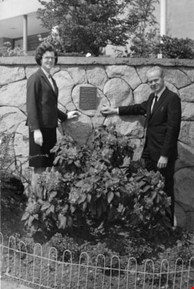
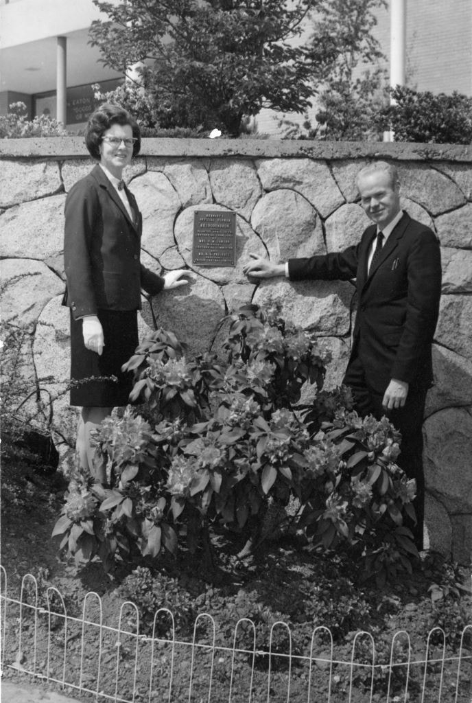
Centennial Planting
https://search.heritageburnaby.ca/link/archivedescription89115
- Repository
- City of Burnaby Archives
- Date
- 1967
- Collection/Fonds
- Doreen Lawson fonds
- Description Level
- Item
- Physical Description
- 1 photograph : b&w ; 17 x 11 mounted on board 19 x 21.5 cm
- Scope and Content
- Photograph of "Centennial Planting" event held at Brentwood Shopping Centre. Mr. D. Haywood and Doreen Lawson stand alongside a Rhododendron bush. On August 22, 1966, Burnaby Municipal Council with recommendation from the Burnaby Parks and Recreation Commission adopted the Rhododendron as the offi…
- Repository
- City of Burnaby Archives
- Date
- 1967
- Collection/Fonds
- Doreen Lawson fonds
- Physical Description
- 1 photograph : b&w ; 17 x 11 mounted on board 19 x 21.5 cm
- Description Level
- Item
- Record No.
- 605-003
- Access Restriction
- No restrictions
- Reproduction Restriction
- Reproduce for fair dealing purposes only
- Accession Number
- 2003-30
- Scope and Content
- Photograph of "Centennial Planting" event held at Brentwood Shopping Centre. Mr. D. Haywood and Doreen Lawson stand alongside a Rhododendron bush. On August 22, 1966, Burnaby Municipal Council with recommendation from the Burnaby Parks and Recreation Commission adopted the Rhododendron as the official flower of Burnaby.
- Subjects
- Plants - Flowers
- Names
- Lawson, Doreen A.
- Haywood, D.
- Media Type
- Photograph
- Notes
- Title based on photograph
- Stamp on verso of photograph reads: "Brentwood_Shopping_Centre_Association / 1000_Brentwood / 4567_Lougheed_Highway / Burnaby_BC"
- Note in pencil on verso of photograph reads: "May_67 / Centennial_planting / 100_[?] / Mr._D._Haywood / Mrs_Lawson"
- Planning Study Area
- Brentwood Area
Images
Burnaby Rhododendron and Spring Flower Show Society
https://search.heritageburnaby.ca/link/archivedescription91565
- Repository
- City of Burnaby Archives
- Date
- 1969-1971
- Collection/Fonds
- Doreen Lawson fonds
- Description Level
- File
- Physical Description
- 3 photographs : col. and b&w ; 9 cm x 12.5 cm
- Scope and Content
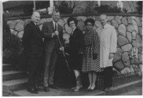
- File consists of photographs of the Burnaby Rhododendron and Spring Flower Show Society. Two photographs depict flower show displays while the other depicts Doreen Lawson posing with four unidentified individuals in front of a garden. One of the individuals is holding a shovel.
- Repository
- City of Burnaby Archives
- Date
- 1969-1971
- Collection/Fonds
- Doreen Lawson fonds
- Physical Description
- 3 photographs : col. and b&w ; 9 cm x 12.5 cm
- Description Level
- File
- Record No.
- 605-004
- Access Restriction
- No restrictions
- Reproduction Restriction
- Reproduce for fair dealing purposes only
- Accession Number
- 2003-30
- Scope and Content
- File consists of photographs of the Burnaby Rhododendron and Spring Flower Show Society. Two photographs depict flower show displays while the other depicts Doreen Lawson posing with four unidentified individuals in front of a garden. One of the individuals is holding a shovel.
- Names
- Lawson, Doreen A.
- Media Type
- Photograph
- Notes
- Transcribed title
- Title based on contents of photographs
- Separated from file MSS071-010
- Handwritten note on verso of 605-004-1 reads: "Lao [?] Clark"
Images


3rd Annual Burnaby Rhododendron and Spring Flower Show photographs
https://search.heritageburnaby.ca/link/archivedescription91569
- Repository
- City of Burnaby Archives
- Date
- May 1969
- Collection/Fonds
- Doreen Lawson fonds
- Description Level
- File
- Physical Description
- 5 photographs : col. ; 9 cm x 11 cm
- Scope and Content
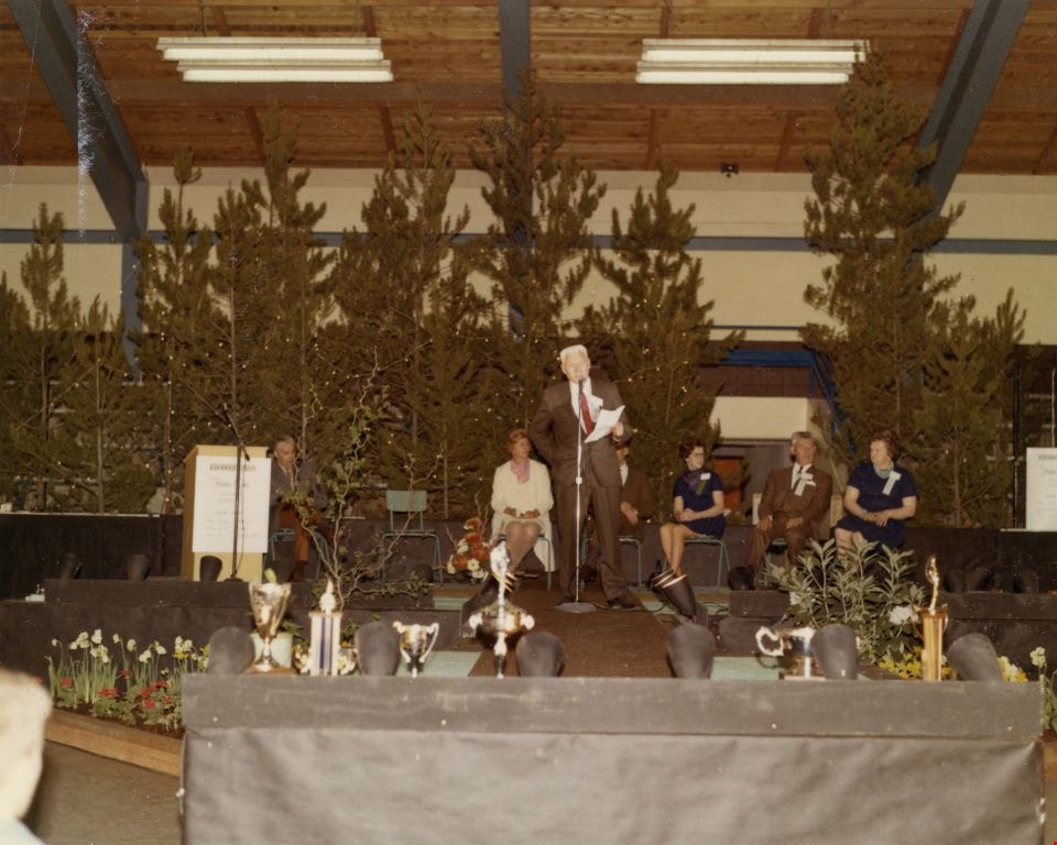
- File consists of photographs of the third annual Burnaby Rhododendron and Spring Flower Show awards ceremony. Photographs depict Burnaby Rhododendron and Spring Flower Show Society President Doreen Lawson, Show Chairman Lloyd Smith, and an unidentified man giving speeches to the crowd of attendees.
- Repository
- City of Burnaby Archives
- Date
- May 1969
- Collection/Fonds
- Doreen Lawson fonds
- Physical Description
- 5 photographs : col. ; 9 cm x 11 cm
- Description Level
- File
- Record No.
- 605-005
- Access Restriction
- No restrictions
- Reproduction Restriction
- Reproduce for fair dealing purposes only
- Accession Number
- 2003-30
- Scope and Content
- File consists of photographs of the third annual Burnaby Rhododendron and Spring Flower Show awards ceremony. Photographs depict Burnaby Rhododendron and Spring Flower Show Society President Doreen Lawson, Show Chairman Lloyd Smith, and an unidentified man giving speeches to the crowd of attendees.
- Names
- Lawson, Doreen A.
- Media Type
- Photograph
- Notes
- Title based on contents of photographs
- Stamp on verso of photographs 605-005-1 and 605-005-5 reads: "Gai paree Supper Club Ltd. / [Contact information]"
Images
1st Annual Burnaby Rhododendron and Spring Flower Show photographs
https://search.heritageburnaby.ca/link/archivedescription91570
- Repository
- City of Burnaby Archives
- Date
- May 1969
- Collection/Fonds
- Doreen Lawson fonds
- Description Level
- File
- Physical Description
- 13 photographs : col. ; 9 cm x 12.5 cm and smaller
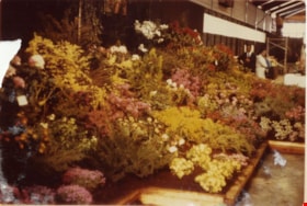
- Scope and Content
- File consists of photographs of the first annual Burnaby Rhododendron and Spring Flower Show. Photographs depict various exhibitors' displays, including the BC Nursery Trade Society, Planned Parenthood, Board of Parks and Public Recreation (City of Vancouver), and Burnaby Parks and Recreation.
- Repository
- City of Burnaby Archives
- Date
- May 1969
- Collection/Fonds
- Doreen Lawson fonds
- Physical Description
- 13 photographs : col. ; 9 cm x 12.5 cm and smaller
- Description Level
- File
- Record No.
- 605-006
- Access Restriction
- No restrictions
- Reproduction Restriction
- Reproduce for fair dealing purposes only
- Accession Number
- 2003-30
- Scope and Content
- File consists of photographs of the first annual Burnaby Rhododendron and Spring Flower Show. Photographs depict various exhibitors' displays, including the BC Nursery Trade Society, Planned Parenthood, Board of Parks and Public Recreation (City of Vancouver), and Burnaby Parks and Recreation.
- Names
- Lawson, Doreen A.
- Media Type
- Photograph
- Photographer
- Brandson, Lloyd S.
- Knudson, Art
- Notes
- Title based on contents of photographs
- Note in blue ink on verso of photograph 605-006-1 reads: "Burnaby Centennial Committee / 25.00 / Doug Earlaw"
- Note in pencil on verso of photographs 605-006-3 : 605-006-6 reads: "Lloyd. S. Brandson / [address] / [phone]
- Note in blue ink on verso of photograph 605-006-7 reads: ""Golden Sunset" / Art Knudson / [address] / [phone]"
- Note in blue ink on verso of photograph 605-006-13 reads: "Art Knudson / [contact information
Images


The "Back Lane"
https://search.heritageburnaby.ca/link/archivedescription91858
- Repository
- City of Burnaby Archives
- Date
- 1965
- Collection/Fonds
- Small family fonds
- Description Level
- Item
- Physical Description
- 1 photograph : b&w ; 9.5 cm x 9.5 cm
- Scope and Content
- Photograph of the back lane between Dominion Street and Norfolk Street. The lane is filled with trees, including a large cedar tree (centre) and cherry tree (left). The photograph was taken looking east along the lane. In 1965-66 the lane was put through from Douglas Road to Royal Oak and the tr…
- Repository
- City of Burnaby Archives
- Date
- 1965
- Collection/Fonds
- Small family fonds
- Physical Description
- 1 photograph : b&w ; 9.5 cm x 9.5 cm
- Description Level
- Item
- Record No.
- 620-039
- Access Restriction
- No restrictions
- Reproduction Restriction
- No reproduction permitted
- Accession Number
- 2017-01
- Scope and Content
- Photograph of the back lane between Dominion Street and Norfolk Street. The lane is filled with trees, including a large cedar tree (centre) and cherry tree (left). The photograph was taken looking east along the lane. In 1965-66 the lane was put through from Douglas Road to Royal Oak and the trees and undergrowth were removed.
- Media Type
- Photograph
- Notes
- Transcribed title
- Title transcribed from donor's notes
- Note in blue ink on verso of photograph reads: "P.2"
- Note in blue ink on verso of photograph reads: "Old Cedar Tree - chopped down for alley - Fall - 1965"
- Caption on border of recto of photograph reads: "Dec"
- Geographic Access
- Dominion Street
- Historic Neighbourhood
- Burnaby Lake (Historic Neighbourhood)
- Planning Study Area
- Ardingley-Sprott Area
Images

![William Brenchley farm, [between 1890 and 1895] (date of original), copied 1985 thumbnail](/media/hpo/_Data/_Archives_Images/_Unrestricted/126/146-002.jpg?width=280)
William Brenchley farm
https://search.heritageburnaby.ca/link/archivedescription34864
- Repository
- City of Burnaby Archives
- Date
- [between 1890 and 1895] (date of original), copied 1985
- Collection/Fonds
- Burnaby Historical Society fonds
- Description Level
- Item
- Physical Description
- 1 photograph : b&w ; 8.8 x 12.5 cm print
- Scope and Content
- Photograph of a farm hand and horse team inside a large stump, taken on William Brenchley's farm. The farm was located at the northeast corner of Kingsway and 10th Avenue.
- Repository
- City of Burnaby Archives
- Date
- [between 1890 and 1895] (date of original), copied 1985
- Collection/Fonds
- Burnaby Historical Society fonds
- Subseries
- W.E. Brenchley subseries
- Physical Description
- 1 photograph : b&w ; 8.8 x 12.5 cm print
- Description Level
- Item
- Record No.
- 146-002
- Access Restriction
- No restrictions
- Reproduction Restriction
- No known restrictions
- Accession Number
- BHS1985-16
- Scope and Content
- Photograph of a farm hand and horse team inside a large stump, taken on William Brenchley's farm. The farm was located at the northeast corner of Kingsway and 10th Avenue.
- Media Type
- Photograph
- Photographer
- Thompson, S.J.
- Notes
- Title based on contents of photograph
- Geographic Access
- 10th Avenue
- Kingsway
- Historic Neighbourhood
- Edmonds (Historic Neighbourhood)
- Planning Study Area
- Edmonds Area
Images
![William Brenchley farm, [between 1890 and 1895] (date of original), copied 1985 thumbnail](/media/hpo/_Data/_Archives_Images/_Unrestricted/126/146-002.jpg)
Ida and Hay Cary
https://search.heritageburnaby.ca/link/archivedescription37580
- Repository
- City of Burnaby Archives
- Date
- July 24, 1962 (date of original), copied 1991
- Collection/Fonds
- Burnaby Historical Society fonds
- Description Level
- Item
- Physical Description
- 1 photograph : b&w ; 3.9 x 3.9 cm print on contact sheet 20.2 x 25.3 cm
- Scope and Content
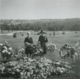
- Photograph of Ida and Hay Cary (widow of Norm Cary) standing beside wreaths and flowers at a funeral at Forest Lawn Cemetery.
- Repository
- City of Burnaby Archives
- Date
- July 24, 1962 (date of original), copied 1991
- Collection/Fonds
- Burnaby Historical Society fonds
- Subseries
- Burnaby Image Bank subseries
- Physical Description
- 1 photograph : b&w ; 3.9 x 3.9 cm print on contact sheet 20.2 x 25.3 cm
- Description Level
- Item
- Record No.
- 370-168
- Access Restriction
- No restrictions
- Reproduction Restriction
- No restrictions
- Accession Number
- BHS1999-03
- Scope and Content
- Photograph of Ida and Hay Cary (widow of Norm Cary) standing beside wreaths and flowers at a funeral at Forest Lawn Cemetery.
- Media Type
- Photograph
- Notes
- Title based on contents of photograph
- 1 b&w copy negative accompanying
- Copied from a col. photograph
- Negative has a pink cast
- Geographic Access
- Royal Oak Avenue
- Street Address
- 3789 Royal Oak Avenue
- Planning Study Area
- Douglas-Gilpin Area
Images


People next to a large fallen tree
https://search.heritageburnaby.ca/link/archivedescription39514
- Repository
- City of Burnaby Archives
- Date
- 1898
- Collection/Fonds
- Peers Family and Hill Family fonds
- Description Level
- Item
- Physical Description
- 1 photograph : sepia ; 9.8 x 13.5 cm on page 21.5 x 28 cm (pasted in album)
- Scope and Content
- Photograph of a group of people next to a very large fallen tree. The photograph was taken just above Deer Lake Avenue and the home of Bernard Hill can be seen in the background. Identified in the picture are Mrs. Sprott (standing in front of tree to the left), directly in front of her, lying on th…
- Repository
- City of Burnaby Archives
- Date
- 1898
- Collection/Fonds
- Peers Family and Hill Family fonds
- Physical Description
- 1 photograph : sepia ; 9.8 x 13.5 cm on page 21.5 x 28 cm (pasted in album)
- Description Level
- Item
- Record No.
- 477-833
- Access Restriction
- No restrictions
- Reproduction Restriction
- No known restrictions
- Accession Number
- 2007-12
- Scope and Content
- Photograph of a group of people next to a very large fallen tree. The photograph was taken just above Deer Lake Avenue and the home of Bernard Hill can be seen in the background. Identified in the picture are Mrs. Sprott (standing in front of tree to the left), directly in front of her, lying on the ground is Bernard Hill. The woman standing farthest to the right (next to man holding child) is Marian Hill and next to her is Claude Hill holding his daughter Kitty. The man farthest to the right is Mr. Sprott. The rest are unidentified.
- Subjects
- Land Clearing
- Plants - Trees
- Names
- Hill, Bernard R.
- Hill, Marian Berkeley
- Hill, Louis Claude "Claude"
- Peers, Katherine Maude Hill "Kitty"
- Media Type
- Photograph
- Notes
- Title based on caption accompanying photograph
- Geographic Access
- Deer Lake Avenue
- Historic Neighbourhood
- Burnaby Lake (Historic Neighbourhood)
- Planning Study Area
- Douglas-Gilpin Area
Images

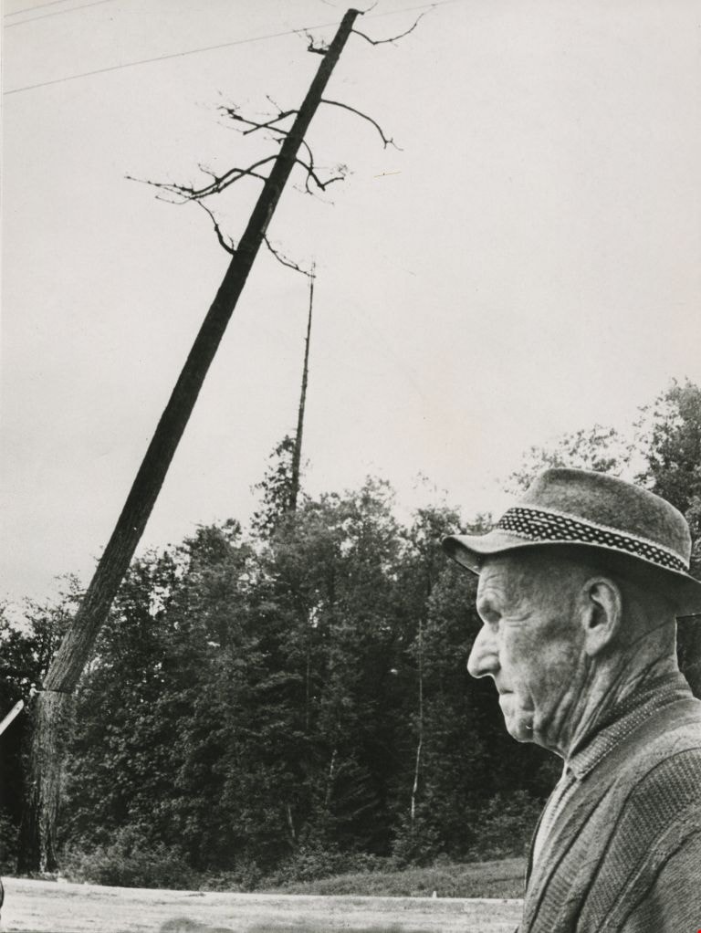
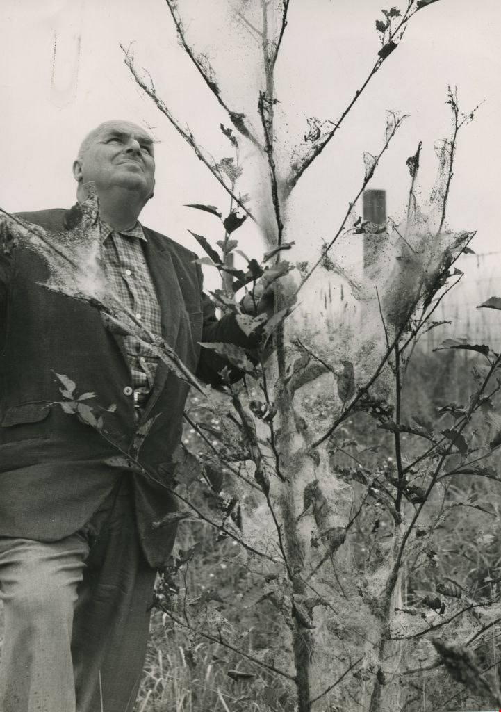
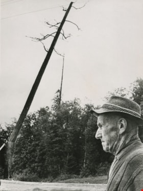
William Hawley surveys tree destruction
https://search.heritageburnaby.ca/link/archivedescription45198
- Repository
- City of Burnaby Archives
- Date
- 1962, published September 8, 1962
- Collection/Fonds
- Columbian Newspaper collection
- Description Level
- Item
- Physical Description
- 1 photograph : b&w ; 20 x 14 cm
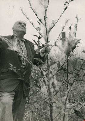
- Scope and Content
- Photograph of Columbian farm and garden columnist William Hawley surveying tree destruction caused by tent caterpillars. He was the garden columnist for most of the 1960's, and prior to that he was a salesman and nutritionist for Brackman-Kerr feed store in New Westminster for 40 years. He and his …
- Repository
- City of Burnaby Archives
- Date
- 1962, published September 8, 1962
- Collection/Fonds
- Columbian Newspaper collection
- Physical Description
- 1 photograph : b&w ; 20 x 14 cm
- Description Level
- Item
- Record No.
- 480-094
- Access Restriction
- No restrictions
- Reproduction Restriction
- Reproduce for fair dealing purposes only
- Accession Number
- 2003-02
- Scope and Content
- Photograph of Columbian farm and garden columnist William Hawley surveying tree destruction caused by tent caterpillars. He was the garden columnist for most of the 1960's, and prior to that he was a salesman and nutritionist for Brackman-Kerr feed store in New Westminster for 40 years. He and his wife Doreen were married for 52 years.
- Subjects
- Occupations - Journalists
- Plants - Trees
- Media Type
- Photograph
- Notes
- Title based on contents of photograph
Images
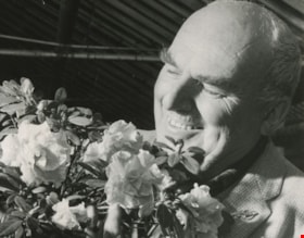
William Hawley admires an azalea
https://search.heritageburnaby.ca/link/archivedescription45199
- Repository
- City of Burnaby Archives
- Date
- 1961, published November 25, 1961
- Collection/Fonds
- Columbian Newspaper collection
- Description Level
- Item
- Physical Description
- 1 photograph : b&w ; 7.5 x 9.5 cm
- Scope and Content
- Photograph of Columbian farm and garden columnist William Hawley admiring an azalea which was early to flower. He was the garden columnist for most of the 1960's, and prior to that he was a salesman and nutritionist for Brackman-Kerr feed store in New Westminster for 40 years. He and his wife Doree…
- Repository
- City of Burnaby Archives
- Date
- 1961, published November 25, 1961
- Collection/Fonds
- Columbian Newspaper collection
- Physical Description
- 1 photograph : b&w ; 7.5 x 9.5 cm
- Description Level
- Item
- Record No.
- 480-095
- Access Restriction
- No restrictions
- Reproduction Restriction
- No restrictions
- Accession Number
- 2003-02
- Scope and Content
- Photograph of Columbian farm and garden columnist William Hawley admiring an azalea which was early to flower. He was the garden columnist for most of the 1960's, and prior to that he was a salesman and nutritionist for Brackman-Kerr feed store in New Westminster for 40 years. He and his wife Doreen were married for 52 years.
- Media Type
- Photograph
- Photographer
- King, Basil
- Notes
- Title based on contents of photograph
Images

Charlie Perkins
https://search.heritageburnaby.ca/link/archivedescription46125
- Repository
- City of Burnaby Archives
- Date
- 1968
- Collection/Fonds
- Columbian Newspaper collection
- Description Level
- Item
- Physical Description
- 1 photograph : b&w photomontage ; 20 x 15 cm
- Scope and Content
- Photograph of World War I veteran Charlie Perkins watching as a "woodsman's saw" cuts down the tree that originally had been spared when the Port Mann freeway was built around it. (Charlie Perkins had planted ivy around the tree in 1920 as a memorial to his fallen comrades in the Royal Canadian Air…
- Repository
- City of Burnaby Archives
- Date
- 1968
- Collection/Fonds
- Columbian Newspaper collection
- Physical Description
- 1 photograph : b&w photomontage ; 20 x 15 cm
- Description Level
- Item
- Record No.
- 480-1013
- Access Restriction
- No restrictions
- Reproduction Restriction
- Reproduce for fair dealing purposes only
- Accession Number
- 2003-02
- Scope and Content
- Photograph of World War I veteran Charlie Perkins watching as a "woodsman's saw" cuts down the tree that originally had been spared when the Port Mann freeway was built around it. (Charlie Perkins had planted ivy around the tree in 1920 as a memorial to his fallen comrades in the Royal Canadian Air Force). A photograph of Charlie Perkins was collaged onto photograph of tree being felled, and then re-photographed to create this seamless montaged photograph.
- Names
- Perkins, Charlie
- Media Type
- Photograph
- Notes
- Title based on contents of photograph
Images