Narrow Results By
Subject
- Agriculture - Crops 4
- Agriculture - Fruit and Berries 6
- Animals - Bears 1
- Animals - Birds 2
- Animals - Cats 2
- Animals - Deer 1
- Buildings - Civic - Art Galleries 1
- Buildings - Commercial - Grocery Stores 2
- Buildings - Heritage 2
- Buildings - Industrial 1
- Buildings - Industrial - Factories 4
- Buildings - Residential - Cabins 1
![Plants, [1925] thumbnail](/media/hpo/_Data/_Archives_Images/_Unrestricted/477/477-530.jpg?width=280)
Plants
https://search.heritageburnaby.ca/link/archivedescription39211
- Repository
- City of Burnaby Archives
- Date
- [1925]
- Collection/Fonds
- Peers Family and Hill Family fonds
- Description Level
- Item
- Physical Description
- 1 photograph : sepia ; 6 x 10.5 cm on page 24.5 x 32.5 cm (pasted in album)
- Scope and Content
- Photograph of plants next to a building at an unidentified location.
- Repository
- City of Burnaby Archives
- Date
- [1925]
- Collection/Fonds
- Peers Family and Hill Family fonds
- Physical Description
- 1 photograph : sepia ; 6 x 10.5 cm on page 24.5 x 32.5 cm (pasted in album)
- Description Level
- Item
- Record No.
- 477-530
- Access Restriction
- No restrictions
- Reproduction Restriction
- No known restrictions
- Accession Number
- 2007-12
- Scope and Content
- Photograph of plants next to a building at an unidentified location.
- Subjects
- Plants
- Media Type
- Photograph
- Notes
- Title based on contents of photograph
Images
![Plants, [1925] thumbnail](/media/hpo/_Data/_Archives_Images/_Unrestricted/477/477-530.jpg)
Request for Endorsement of Resolution re Sales Tax Requesting the Dominion Government to Exempt Municipal Gravel Pits and Rock Crushing Plants from the Provisions of the Act
https://search.heritageburnaby.ca/link/councilreport66797
- Repository
- City of Burnaby Archives
- Report ID
- 57676
- Meeting Date
- 14-May-1928
- Format
- Council - Mayor/Councillor/Staff Report
- Collection/Fonds
- City Council and Office of the City Clerk fonds
- Repository
- City of Burnaby Archives
- Report ID
- 57676
- Meeting Date
- 14-May-1928
- Format
- Council - Mayor/Councillor/Staff Report
- Collection/Fonds
- City Council and Office of the City Clerk fonds
Documents

Drs. Blythe and Violet Eagles Estate
https://search.heritageburnaby.ca/link/landmark535
- Repository
- Burnaby Heritage Planning
- Description
- The Drs. Blythe and Violet Eagles Estate is a one hectare property located within Deer Lake Park in Burnaby. The property encompasses a carefully conceived garden of local, non-conventional, and exotic plantings. Conceived as a series of rockeries and terraces, the garden cascades from the house do…
- Associated Dates
- 1929
- Formal Recognition
- Heritage Designation, Community Heritage Register
- Other Names
- Eagles Estate Heritage Garden
- Street View URL
- Google Maps Street View
- Repository
- Burnaby Heritage Planning
- Other Names
- Eagles Estate Heritage Garden
- Geographic Access
- Sperling Avenue
- Associated Dates
- 1929
- Formal Recognition
- Heritage Designation, Community Heritage Register
- Enactment Type
- Bylaw No. 11592
- Enactment Date
- 15/09/2003
- Description
- The Drs. Blythe and Violet Eagles Estate is a one hectare property located within Deer Lake Park in Burnaby. The property encompasses a carefully conceived garden of local, non-conventional, and exotic plantings. Conceived as a series of rockeries and terraces, the garden cascades from the house down towards the waterfront, divided by paths and strips of plantings.
- Heritage Value
- The Eagles Estate is significant because of its unique character within Burnaby’s Deer Lake Park heritage precinct, and the people who were its creators and residents. The garden is a unique expression of the talents and tastes of both the Eagles and Frank Ebenezer Buck (1875-1970). Buck served as the Assistant Dominion Horticulturist in charge of landscape horticulture and floriculture in Ottawa from 1912. In 1920, he was head of the Horticultural Department and the Campus Landscape Architect at the University of British Columbia. He established the plan for the Eagles garden while Dr. Blythe Alfred Eagles (1902-1990), the long-time Dean of the Faculty of Agriculture at UBC, selected many of the plantings. The Eagles themselves designed the house as a romantic cottage inspired by the British Arts and Crafts style. Trained in enzyme chemistry, Dr. Violet Evelyn (Dunbar) Eagles (1899-1994) was an enthusiastic amateur gardener, and was perhaps the driving force behind the maintenance and continued development of the garden. The Eagles were also well known in Burnaby for their active volunteerism in the local community as well as at UBC. When Simon Fraser University opened in Burnaby as the Greater Vancouver’s second university, the Eagles, in particular Violet, became well-known for entertaining dignitaries and special guests of the university in their lavish garden. Drs. Blythe and Violet Eagles were recognized for their good citizenship and the ongoing use of their garden for charitable Burnaby-based functions and celebrations.
- Defining Elements
- Due to the extensive and varied nature of the garden, the character-defining elements of the Eagles Estate are many and complex. The elements that encompass the character of the site include its: - British Arts and Crafts-inspired house with original exterior features such as a picturesque roofline, stucco cladding and six- and eight-paned steel-frame casement windows, and original interior features such as the central fireplace, wood floors and kitchen cabinetry - formal staircase leading to the north (formal entry) side of the house - carefully planned yet informal garden design, with 'garden rooms' used to create intimacy - terraced landscape cascading from the house down to the garden - incorporation of local, exotic, flowering and non-flowering plants. - contrast of manicured versus freely growing landscape elements - use of wood lattice fencing gates, arbors and trellis
- Historic Neighbourhood
- Burnaby Lake (Historic Neighbourhood)
- Planning Study Area
- Morley-Buckingham Area
- Community
- Burnaby
- Cadastral Identifier
- P.I.D. No. 007-302-801 Legal Description: Lot 143, District Lot 85, Group 1, New Westminster District, Plan 36335
- Boundaries
- The Eagles Estate is comprised of a single municipally-owned property located at 5655 Sperling Avenue, Burnaby.
- Area
- 6,403.91
- Contributing Resource
- Building
- Landscape Feature
- Documentation
- Heritage Site Files: PC77000 20. City of Burnaby Planning and Building Department, 4949 Canada Way, Burnaby, B.C., V5G 1M2
- Street Address
- 5655 Sperling Avenue
- Street View URL
- Google Maps Street View
Images


Barnet Neighbourhood
https://search.heritageburnaby.ca/link/landmark747
- Repository
- Burnaby Heritage Planning
- Associated Dates
- 1905-1924
- Heritage Value
- The original Barnet mill burned down in 1909 after a dramatic explosion in the boiler house. The company rebuilt a new plant, considered a model of mill construction. The company's timber was towed down the Pacific in huge rafts containing about 400,000 to 500,000 board feet. Mill capacity during a 10-hour day was 150,000 board feet with an amazing annual output of 50 million feet.
- Historic Neighbourhood
- Barnet (Historic Neighbourhood)
- Planning Study Area
- Burnaby Mountain Area
Images


Brentwood Neighbourhood
https://search.heritageburnaby.ca/link/landmark780
- Repository
- Burnaby Heritage Planning
- Associated Dates
- 1955-2008
- Heritage Value
- Between 1955 and 2001, the Brentwood Neighbourhood developed into one of Burnaby's four official Town Centres. The Brentwood Town Centre serves the north-west sector of the Municipality, providing facilities such as commercial developments - of which the Brentwood Mall is the most significant. Under Burnaby's Residential Development Framework adopted by Council in 1981, the Town Centre also incorporated a full range of multi-housing types and forms in close relationship with their commercial facilities. In 1996, the City adopted the Brentwood Town Centre Development Plant to solidify the area as a focus of higher-density and higher-intensity residential and commercial opportunities, public transit and supporting leisure facilities.
- Planning Study Area
- Brentwood Area
Images


Broadview Neighbourhood
https://search.heritageburnaby.ca/link/landmark687
- Repository
- Burnaby Heritage Planning
- Associated Dates
- 1925-1954
- Heritage Value
- Development in the Broadview area slowed during World War Two, but after the war, the area became home to a number of industrial sites. The first major plant to be built here was the Dominion Bridge Company which opened in 1930.
- Historic Neighbourhood
- Broadview (Historic Neighbourhood)
- Planning Study Area
- Cascade-Schou Area
Images


Kask Brothers
https://search.heritageburnaby.ca/link/landmark684
- Repository
- Burnaby Heritage Planning
- Geographic Access
- Barnet Road
- Associated Dates
- 1925
- Heritage Value
- In 1925, William Kask Sr. and his family purchased land along the Barnet Road and built what became known as Kask's Camp, where cabins were rented out to families working at the Barnet Mill. The family - William Kask Jr., Dave and Jack - went on to expand their business into a lumber and concrete supply company and in 1936, the company was named the Kask Brothers Building Supply Company. A lumber office was established on Curtis Street and the concrete plant was built at the former site of the cabin camp. To a large degree, the camp catered to Immigrants from Nordic countries who were active in the lumber trade. Many Finns felt at home in the camp, as the Kasks spoke Finnish and there were steam baths available.
- Historic Neighbourhood
- Lochdale (Historic Neighbourhood)
- Planning Study Area
- Westridge Area
- Street Address
- 7501 Barnet Road
Images


Shell Oil Company
https://search.heritageburnaby.ca/link/landmark675
- Repository
- Burnaby Heritage Planning
- Geographic Access
- Kensington Avenue
- Associated Dates
- ca. 1930-1993
- Heritage Value
- After considering several sites in the Greater Vancouver area, the Shell Oil Company chose 70 acres in North Burnaby with frontage of one third of a mile on Burrard Inlet. Shell proposed to build a four-million dollar plant that would employ up to 2000 - providing some relief in the middle of Burnaby's economic crisis of the Depression years. The site became known as the Shellburn Refinery and was in operation until 1993.
- Historic Neighbourhood
- Lochdale (Historic Neighbourhood)
- Planning Study Area
- Westridge Area
Images

Copies of photographs from Esther (Love) Stanley albums
https://search.heritageburnaby.ca/link/museumdescription10003
- Repository
- Burnaby Village Museum
- Date
- [1915-1950] (date of originals), copied 1989
- Collection/Fonds
- Burnaby Village Museum fonds
- Description Level
- File
- Physical Description
- 36 photographs : b&w negatives ; 35 mm
- Scope and Content
- Photographs copied from various photograph albums including; Albert Paker, George Love, Gordon Love and Esther (Love) Stanley. Content includes: Love family in front of the piano inside parlour; Love family members with musical instruments inside parlour; Ben Brandrith and Robert Love in uniforms; …
- Repository
- Burnaby Village Museum
- Collection/Fonds
- Burnaby Village Museum fonds
- Series
- Jesse Love farmhouse series
- Subseries
- Love family photographs subseries
- Description Level
- File
- Physical Description
- 36 photographs : b&w negatives ; 35 mm
- Scope and Content
- Photographs copied from various photograph albums including; Albert Paker, George Love, Gordon Love and Esther (Love) Stanley. Content includes: Love family in front of the piano inside parlour; Love family members with musical instruments inside parlour; Ben Brandrith and Robert Love in uniforms; unidentified Asian man in field with hoe and young trees behind him; wedding cake from Frank Charles Stanley and Esther Love's wedding; land clearing for Love farmhouse; Jesse Love feeding chickens; Jesse and Hannah (Girlie) Love in hats outside on Love farm; large picnic on grass; four generations of Love family members; gatherings of Love family members outside; Love family posed in a car inside a studio (Will, Sarah, George, Phoebe and Martha); Leonard Love dressed as a boy scout; Martha (Dot) with children; Love family members celebrate centennial; Jesse Love and Martha (Dot) Love outside Love farmhouse; Love farmhouse with porch and garden; swing at Love farmhouse; Parker family in living room and view of the Love farmhouse from the front.
- Geographic Access
- Cumberland Street
- Street Address
- 7651 Cumberland Street
- Accession Code
- BV018.41.184
- Access Restriction
- No restrictions
- Reproduction Restriction
- May be restricted by third party rights
- Date
- [1915-1950] (date of originals), copied 1989
- Media Type
- Photograph
- Historic Neighbourhood
- East Burnaby (Historic Neighbourhood)
- Planning Study Area
- Cariboo-Armstrong Area
- Scan Date
- 4-Mar-2019
- Notes
- Title based on contents of photograph
- 36 b&w copy prints accompanying

1982 - Moving the Roberts House
https://search.heritageburnaby.ca/link/archivedescription91880
- Repository
- City of Burnaby Archives
- Date
- 1982
- Collection/Fonds
- Small family fonds
- Description Level
- Item
- Physical Description
- 1 photograph : col. copy print ; 10 cm x 15 cm
- Scope and Content
- Photograph of the land being cleared at 5496 Dominion Street in order to create a path to move the Roberts' house onto the property. Included in the clearing are the stumps of two apples trees, a poplar tree, and a maple tree. The debris from the site was burned and smoke can seen rising from a s…
- Repository
- City of Burnaby Archives
- Date
- 1982
- Collection/Fonds
- Small family fonds
- Physical Description
- 1 photograph : col. copy print ; 10 cm x 15 cm
- Description Level
- Item
- Record No.
- 620-061
- Access Restriction
- No restrictions
- Reproduction Restriction
- No reproduction permitted
- Accession Number
- 2017-01
- Scope and Content
- Photograph of the land being cleared at 5496 Dominion Street in order to create a path to move the Roberts' house onto the property. Included in the clearing are the stumps of two apples trees, a poplar tree, and a maple tree. The debris from the site was burned and smoke can seen rising from a small pile of brush on the right.
- Media Type
- Photograph
- Notes
- Transcribed title
- Title transcribed from donor's notes
- Note in blue ink on verso of photograph reads: "p.3"
- Note in pencil on verso of photograph reads: "2"
- Street Address
- 5496 Dominion Street
- Historic Neighbourhood
- Burnaby Lake (Historic Neighbourhood)
- Planning Study Area
- Ardingley-Sprott Area
Images


1982 - Moving the Roberts House 5538 Dominion Street to its new location at 5496 Dominion Street
https://search.heritageburnaby.ca/link/archivedescription91879
- Repository
- City of Burnaby Archives
- Date
- 1982
- Collection/Fonds
- Small family fonds
- Description Level
- Item
- Physical Description
- 1 photograph : col. ; 9 cm x 13 cm
- Scope and Content
- Photograph of the site at 5496 Dominion Street where the Roberts' house was to be moved. To the left is the old garage that was originally part of the small dwelling the Roberts lived in during the construction of their house in the early 1920s. In the background is 3093 Douglas Road and in the f…
- Repository
- City of Burnaby Archives
- Date
- 1982
- Collection/Fonds
- Small family fonds
- Physical Description
- 1 photograph : col. ; 9 cm x 13 cm
- Description Level
- Item
- Record No.
- 620-060
- Access Restriction
- No restrictions
- Reproduction Restriction
- No reproduction permitted
- Accession Number
- 2017-01
- Scope and Content
- Photograph of the site at 5496 Dominion Street where the Roberts' house was to be moved. To the left is the old garage that was originally part of the small dwelling the Roberts lived in during the construction of their house in the early 1920s. In the background is 3093 Douglas Road and in the foreground are two apple trees planted by John W. Roberts.
- Media Type
- Photograph
- Notes
- Transcribed title
- Title transcribed from donor's notes
- Note in blue ink on verso of photograph reads: "p.2"
- Note in blue ink on verso of photograph reads: "Garage, Poplar Tree and Apple Trees before they had to go to make room to move house here / Spring 1982"
- 5118 Douglas Road renumbered to 3131 Douglas Road in 1958 and to 5538 Dominion Street in 1970 or 1971
- Street Address
- 5496 Dominion Street
- Historic Neighbourhood
- Burnaby Lake (Historic Neighbourhood)
- Planning Study Area
- Ardingley-Sprott Area
Images


6742 Walker Avenue
https://search.heritageburnaby.ca/link/archivedescription37844
- Repository
- City of Burnaby Archives
- Date
- May 1987 (date of original), copied 1991
- Collection/Fonds
- Burnaby Historical Society fonds
- Description Level
- Item
- Physical Description
- 1 photograph : b&w ; 3.1 x 4.3 cm print on contact sheet 20.6 x 26.7 cm
- Scope and Content
- Photograph of 6742 Walker Avenue, with only the trees in the yard visible from the road. A van is parked in front.
- Repository
- City of Burnaby Archives
- Date
- May 1987 (date of original), copied 1991
- Collection/Fonds
- Burnaby Historical Society fonds
- Subseries
- Burnaby Image Bank subseries
- Physical Description
- 1 photograph : b&w ; 3.1 x 4.3 cm print on contact sheet 20.6 x 26.7 cm
- Description Level
- Item
- Record No.
- 370-432
- Access Restriction
- No restrictions
- Reproduction Restriction
- No restrictions
- Accession Number
- BHS1999-03
- Scope and Content
- Photograph of 6742 Walker Avenue, with only the trees in the yard visible from the road. A van is parked in front.
- Subjects
- Plants - Trees
- Media Type
- Photograph
- Notes
- Title based on contents of photograph
- 1 b&w copy negative accompanying
- Negative has a pink cast
- Copied from col. photograph
- Geographic Access
- Walker Avenue
- Street Address
- 6742 Walker Avenue
- Historic Neighbourhood
- Edmonds (Historic Neighbourhood)
- Planning Study Area
- Richmond Park Area
Images


6742 Walker Avenue
https://search.heritageburnaby.ca/link/archivedescription37845
- Repository
- City of Burnaby Archives
- Date
- May 1987 (date of original), copied 1991
- Collection/Fonds
- Burnaby Historical Society fonds
- Description Level
- Item
- Physical Description
- 1 photograph : b&w ; 3.0 x 4.4 cm print on contact sheet 20.6 x 26.7 cm
- Scope and Content
- Photograph of 6742 Walker Avenue with some of the trees in the yard cut down.
- Repository
- City of Burnaby Archives
- Date
- May 1987 (date of original), copied 1991
- Collection/Fonds
- Burnaby Historical Society fonds
- Subseries
- Burnaby Image Bank subseries
- Physical Description
- 1 photograph : b&w ; 3.0 x 4.4 cm print on contact sheet 20.6 x 26.7 cm
- Description Level
- Item
- Record No.
- 370-433
- Access Restriction
- No restrictions
- Reproduction Restriction
- No restrictions
- Accession Number
- BHS1999-03
- Scope and Content
- Photograph of 6742 Walker Avenue with some of the trees in the yard cut down.
- Subjects
- Plants - Trees
- Media Type
- Photograph
- Notes
- Title based on contents of photograph
- 1 b&w copy negative accompanying
- Negative has a pink cast
- Copied from col. photograph
- Geographic Access
- Walker Avenue
- Street Address
- 6742 Walker Avenue
- Historic Neighbourhood
- Edmonds (Historic Neighbourhood)
- Planning Study Area
- Richmond Park Area
Images


6742 Walker Avenue
https://search.heritageburnaby.ca/link/archivedescription37846
- Repository
- City of Burnaby Archives
- Date
- May 1987 (date of original), copied 1991
- Collection/Fonds
- Burnaby Historical Society fonds
- Description Level
- Item
- Physical Description
- 1 photograph : b&w ; 3.0 x 4.3 cm print on contact sheet 20.6 x 26.7 cm
- Scope and Content
- Photograph of 6742 Walker Avenue, showing the stumps of the recently cut down trees in the yard of the house.
- Repository
- City of Burnaby Archives
- Date
- May 1987 (date of original), copied 1991
- Collection/Fonds
- Burnaby Historical Society fonds
- Subseries
- Burnaby Image Bank subseries
- Physical Description
- 1 photograph : b&w ; 3.0 x 4.3 cm print on contact sheet 20.6 x 26.7 cm
- Description Level
- Item
- Record No.
- 370-434
- Access Restriction
- No restrictions
- Reproduction Restriction
- No restrictions
- Accession Number
- BHS1999-03
- Scope and Content
- Photograph of 6742 Walker Avenue, showing the stumps of the recently cut down trees in the yard of the house.
- Media Type
- Photograph
- Notes
- Title based on contents of photograph
- 1 b&w copy negative accompanying
- Negative has a pink cast
- Copied from col. photograph
- Geographic Access
- Walker Avenue
- Street Address
- 6742 Walker Avenue
- Historic Neighbourhood
- Edmonds (Historic Neighbourhood)
- Planning Study Area
- Richmond Park Area
Images

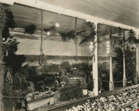
Agricultural Exhibit
https://search.heritageburnaby.ca/link/archivedescription34526
- Repository
- City of Burnaby Archives
- Date
- 1925
- Collection/Fonds
- Burnaby Historical Society fonds
- Description Level
- Item
- Physical Description
- 1 photograph : b&w ; 20.4 x 25.3 cm
- Scope and Content
- Photograph of Burnaby's Agricultural Exhibit at New Westminster. Vegetables, fruit, plants, flowers, and trees are on display inside a building. There is electric lighting. A sign on the right is shaped like an arch and reads, "Welcome to Burnaby." A mural showing Burnaby Lake is behind the dis…
- Repository
- City of Burnaby Archives
- Date
- 1925
- Collection/Fonds
- Burnaby Historical Society fonds
- Subseries
- Photographs subseries
- Physical Description
- 1 photograph : b&w ; 20.4 x 25.3 cm
- Description Level
- Item
- Record No.
- 038-001
- Access Restriction
- No restrictions
- Reproduction Restriction
- No known restrictions
- Accession Number
- BHS2007-04
- Scope and Content
- Photograph of Burnaby's Agricultural Exhibit at New Westminster. Vegetables, fruit, plants, flowers, and trees are on display inside a building. There is electric lighting. A sign on the right is shaped like an arch and reads, "Welcome to Burnaby." A mural showing Burnaby Lake is behind the display.
- Subjects
- Agriculture - Crops
- Exhibitions - Agricultural
- Agriculture - Fruit and Berries
- Plants - Flowers
- Media Type
- Photograph
- Notes
- Title based on contents of photograph
Images

![Agricultural Exhibit, [1920] thumbnail](/media/hpo/_Data/_Archives_Images/_Unrestricted/001/039-001.jpg?width=280)
Agricultural Exhibit
https://search.heritageburnaby.ca/link/archivedescription34527
- Repository
- City of Burnaby Archives
- Date
- [1920]
- Collection/Fonds
- Burnaby Historical Society fonds
- Description Level
- Item
- Physical Description
- 1 photograph : b&w ; 20.4 x 25.3 cm
- Scope and Content
- Photograph of Burnaby's Agricultural Exhibit at New Westminster. Vegetables, fruit, preserves, flowers, and plants are on display inside a building. There is electric lighting. A sign above the display reads, "Burnaby." A sign above a container on the lower left reads, "Ginseng / Grown in Lozel…
- Repository
- City of Burnaby Archives
- Date
- [1920]
- Collection/Fonds
- Burnaby Historical Society fonds
- Subseries
- Photographs subseries
- Physical Description
- 1 photograph : b&w ; 20.4 x 25.3 cm
- Description Level
- Item
- Record No.
- 039-001
- Access Restriction
- No restrictions
- Reproduction Restriction
- No known restrictions
- Accession Number
- BHS2007-04
- Scope and Content
- Photograph of Burnaby's Agricultural Exhibit at New Westminster. Vegetables, fruit, preserves, flowers, and plants are on display inside a building. There is electric lighting. A sign above the display reads, "Burnaby." A sign above a container on the lower left reads, "Ginseng / Grown in Lozells District by Mr. Romer."
- Subjects
- Agriculture - Crops
- Exhibitions - Agricultural
- Agriculture - Fruit and Berries
- Plants - Flowers
- Media Type
- Photograph
- Notes
- Title based on contents of photograph
Images
![Agricultural Exhibit, [1920] thumbnail](/media/hpo/_Data/_Archives_Images/_Unrestricted/001/039-001.jpg)
Agricultural Exhibit
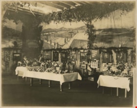
https://search.heritageburnaby.ca/link/archivedescription34528
- Repository
- City of Burnaby Archives
- Date
- 1921
- Collection/Fonds
- Burnaby Historical Society fonds
- Description Level
- Item
- Physical Description
- 1 photograph : b&w ; 20.4 x 25.4 cm
- Scope and Content
- Photograph of Burnaby's Agricultural Exhibit at New Westminster. Tables with fruit, vegetables and flowers are displayed. Greenery and photographs (mainly of people) are on the walls, including a portrait of former Reeve Nicolai C. Schou (second portrait from right). A sign in the corner reads, …
- Repository
- City of Burnaby Archives
- Date
- 1921
- Collection/Fonds
- Burnaby Historical Society fonds
- Subseries
- Photographs subseries
- Physical Description
- 1 photograph : b&w ; 20.4 x 25.4 cm
- Description Level
- Item
- Record No.
- 040-001
- Access Restriction
- No restrictions
- Reproduction Restriction
- No known restrictions
- Accession Number
- BHS2007-04
- Scope and Content
- Photograph of Burnaby's Agricultural Exhibit at New Westminster. Tables with fruit, vegetables and flowers are displayed. Greenery and photographs (mainly of people) are on the walls, including a portrait of former Reeve Nicolai C. Schou (second portrait from right). A sign in the corner reads, "Burnaby's Exhibit," and a mural hangs on the walls above the exhibit. A woman and man are standing behind a table at the back left.
- Subjects
- Agriculture - Crops
- Exhibitions - Agricultural
- Agriculture - Fruit and Berries
- Plants - Flowers
- Documentary Artifacts - Photographs
- Media Type
- Photograph
Images


Alfred Bingham's writings - Track 9
https://search.heritageburnaby.ca/link/oralhistory259
- Repository
- City of Burnaby Archives
- Date Range
- 1919-1939
- Length
- 0:07:31
- Summary
- This portion of the recording includes Alfred Bingham's continuation of reading his series of short stories. He reads; "The ICE AGE and other observations before Burnaby", "The Coming of the Great Trees in Burnaby", "AND THEN MODERN CIVILIZATION STRUCK BURNABY" each written in March of 1962.
- Repository
- City of Burnaby Archives
- Summary
- This portion of the recording includes Alfred Bingham's continuation of reading his series of short stories. He reads; "The ICE AGE and other observations before Burnaby", "The Coming of the Great Trees in Burnaby", "AND THEN MODERN CIVILIZATION STRUCK BURNABY" each written in March of 1962.
- Date Range
- 1919-1939
- Photo Info
- Alfred Bingham, April 20, 1947. Item no. 010-066
- Length
- 0:07:31
- Subjects
- Plants - Trees
- Scope and Content
- Recording is of Alfred Bingham's writings, as read by Alfred Bingham. Major themes discussed are: Pioneers, early days in Burnaby and the Co-op Movement. To view "Narrow By" terms for each track expand this description and see "Notes".
- Biographical Notes
- Alfred "Alf" Bingham was born in England in 1892 and moved to Canada in 1912. His first job in Canada was laying track for the Grand Trunk Pacific Railway (GTPR) from Edmonton to McBride in 1912. His second was in Vancouver at the Rat Portage Mill on False Creek, working on the Resaw machine. He quit after one week due to poor working conditions. After taking part in the 1919 Winnipeg General Strike as a delegate of the Retail and Mailorder Union (A.F.L.) on the Winnipeg Trades and Labour Council, Alfred moved to Burnaby where he and fellow Burnaby residents Aungus McLean and Percy Little worked ten hour days to build a Shingle Mill on the edge of Burnaby Lake for Simpson & Giberson. George Green, carpenter and millwright (author of “The History of Burnaby”) also helped in the construction of the mill. Alfred built his own home from lumber cut from the mill in the Lochdale area on Sherlock Street between Curtis Street and Kitchener Street. On April 10, 1920 Alfred married Mary Jane “Ada” Reynolds. Alfred and Ada often took in foster children during their marriage. Due to her nursing experience, Ada was often called upon to deliver babies in the Burnaby area. Alfred and Ada Bingham were instrumental members of the Army of the Common Good, collecting vegetables and grains from growers in the area and even producing over 125 tons of vegetables from its own gardens to feed children and youth suffering from the lack of resources during the Depression years. The army was in operation for ten years and during that time the members organised the Credit Union movement of British Columbia and drew up the Credit Union act thorough the Vancouver Co-operative Council. They also started Co-Op stores and the Co-Op Wholesale Society. Alfred was also Secretary of the Burnaby Housing committee and in 1946 he became the Secretary of the North Burnaby Labour Progressive Party (LPP). Mary Jane “Ada” (Reynolds) Bingham died on August 9, 1969. Her husband Alfred died on April 29, 1979.
- Total Tracks
- 12
- Total Length
- 1:38:06
- Interviewee Name
- Bingham, Alfred "Alf"
- Collection/Fonds
- Burnaby Historical Society fonds
- Subseries
- Oral history subseries
- Transcript Available
- MSS142-001 contains transcripts for each of the short stories
- Media Type
- Sound Recording
- Web Notes
- Interview was digitized in 2010 allowing it to be accessible on Heritage Burnaby. The digitization project was initiated by the Community Heritage Commission with support from City of Burnaby Council and the BC History Digitization Program of the Irving K. Barber Learning Centre, University of British Columbia. It was recognized by the Heritage Society of BC with an award in 2012.
Images

Audio Tracks
Track nine of recording of Alfred Bingham's writings
Track nine of recording of Alfred Bingham's writings
https://search.heritageburnaby.ca/media/hpo/_Data/_Archives_Oral_Histories/_Unrestricted/100-13-20-2/100-13-20-2_Track_9.mp3
Allanson family clearing land
https://search.heritageburnaby.ca/link/archivedescription35793
- Repository
- City of Burnaby Archives
- Date
- 1923 (date of original), copied 1986
- Collection/Fonds
- Burnaby Historical Society fonds
- Description Level
- Item
- Physical Description
- 1 photograph : b&w ; 12.7 x 17.8 cm print
- Scope and Content
- Photograph of the Allanson family clearing the land at 12 Warwick Avenue bought by Malcolm and Mabel Allanson. Left to right: William Allanson, Mabel Allanson, Malcolm Allanson, and Jessie Allanson. William and Jessie Allanson are the parents of Malcolm. Mabel and Malcolm Allanson are married.
- Repository
- City of Burnaby Archives
- Date
- 1923 (date of original), copied 1986
- Collection/Fonds
- Burnaby Historical Society fonds
- Subseries
- Pioneer Tales subseries
- Physical Description
- 1 photograph : b&w ; 12.7 x 17.8 cm print
- Description Level
- Item
- Record No.
- 204-651
- Access Restriction
- No restrictions
- Reproduction Restriction
- No known restrictions
- Accession Number
- BHS1988-03
- Scope and Content
- Photograph of the Allanson family clearing the land at 12 Warwick Avenue bought by Malcolm and Mabel Allanson. Left to right: William Allanson, Mabel Allanson, Malcolm Allanson, and Jessie Allanson. William and Jessie Allanson are the parents of Malcolm. Mabel and Malcolm Allanson are married.
- Subjects
- Land Clearing
- Plants - Trees
- Media Type
- Photograph
- Notes
- Title based on contents of photograph
- Geographic Access
- Warwick Avenue
- Street Address
- 12 Warwick Avenue
- Historic Neighbourhood
- Capitol Hill (Historic Neighbourhood)
- Planning Study Area
- Capitol Hill Area
Images


Annie Eshelby in front of a felled tree
https://search.heritageburnaby.ca/link/archivedescription35363
- Repository
- City of Burnaby Archives
- Date
- 1924
- Collection/Fonds
- Burnaby Historical Society fonds
- Description Level
- Item
- Physical Description
- 1 photograph : b&w ; 12.7 x 17.8 cm print
- Scope and Content
- Photograph of Mrs. Annie Eshelby in front of a felled tree measuring six feet in diameter. She is sitting on a chair with a black and white cat lying across her lap. This photograph was taken at the lot on Fell Avenue and Dundas Street, North Burnaby, which was cleared for the Eshelby family home. …
- Repository
- City of Burnaby Archives
- Date
- 1924
- Collection/Fonds
- Burnaby Historical Society fonds
- Subseries
- Pioneer Tales subseries
- Physical Description
- 1 photograph : b&w ; 12.7 x 17.8 cm print
- Description Level
- Item
- Record No.
- 204-220
- Access Restriction
- No restrictions
- Reproduction Restriction
- No known restrictions
- Accession Number
- BHS1988-03
- Scope and Content
- Photograph of Mrs. Annie Eshelby in front of a felled tree measuring six feet in diameter. She is sitting on a chair with a black and white cat lying across her lap. This photograph was taken at the lot on Fell Avenue and Dundas Street, North Burnaby, which was cleared for the Eshelby family home. Annie Eshelby (nee Perrey) was married to Frank Eshelby. They settled in Burnaby after moving from England in 1922.
- Subjects
- Animals - Cats
- Land Clearing
- Plants - Trees
- Names
- Eshelby, Annie Perrey
- Media Type
- Photograph
- Notes
- Title based on contents of photograph
- Geographic Access
- Fell Avenue
- Dundas Street
- Historic Neighbourhood
- Capitol Hill (Historic Neighbourhood)
- Planning Study Area
- Capitol Hill Area
Images
