Narrow Results By
Creator
- Alphonse J. Toebaert 1
- Bartel, Mario 36
- Battistoni, Peter 4
- Beach, Chris 1
- Bernard R. Hill 1
- Bowman and Cullerne 1
- Brandson, Lloyd S. 1
- British Columbia Underwriters' Association 10
- Broadbridge Commercial Photo Company 1
- Burnaby Village Museum 7
- Burnett and McGugan B.C. Land Surveyors, New Westminster 5
- Burnett, David H. 1
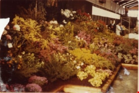
1st Annual Burnaby Rhododendron and Spring Flower Show photographs
https://search.heritageburnaby.ca/link/archivedescription91570
- Repository
- City of Burnaby Archives
- Date
- May 1969
- Collection/Fonds
- Doreen Lawson fonds
- Description Level
- File
- Physical Description
- 13 photographs : col. ; 9 cm x 12.5 cm and smaller
- Scope and Content
- File consists of photographs of the first annual Burnaby Rhododendron and Spring Flower Show. Photographs depict various exhibitors' displays, including the BC Nursery Trade Society, Planned Parenthood, Board of Parks and Public Recreation (City of Vancouver), and Burnaby Parks and Recreation.
- Repository
- City of Burnaby Archives
- Date
- May 1969
- Collection/Fonds
- Doreen Lawson fonds
- Physical Description
- 13 photographs : col. ; 9 cm x 12.5 cm and smaller
- Description Level
- File
- Record No.
- 605-006
- Access Restriction
- No restrictions
- Reproduction Restriction
- Reproduce for fair dealing purposes only
- Accession Number
- 2003-30
- Scope and Content
- File consists of photographs of the first annual Burnaby Rhododendron and Spring Flower Show. Photographs depict various exhibitors' displays, including the BC Nursery Trade Society, Planned Parenthood, Board of Parks and Public Recreation (City of Vancouver), and Burnaby Parks and Recreation.
- Names
- Lawson, Doreen A.
- Media Type
- Photograph
- Photographer
- Brandson, Lloyd S.
- Knudson, Art
- Notes
- Title based on contents of photographs
- Note in blue ink on verso of photograph 605-006-1 reads: "Burnaby Centennial Committee / 25.00 / Doug Earlaw"
- Note in pencil on verso of photographs 605-006-3 : 605-006-6 reads: "Lloyd. S. Brandson / [address] / [phone]
- Note in blue ink on verso of photograph 605-006-7 reads: ""Golden Sunset" / Art Knudson / [address] / [phone]"
- Note in blue ink on verso of photograph 605-006-13 reads: "Art Knudson / [contact information
Images


2007 Advisory Planning Commission portrait
https://search.heritageburnaby.ca/link/archivedescription90391
- Repository
- City of Burnaby Archives
- Date
- 2007
- Collection/Fonds
- City Council and Office of the City Clerk fonds
- Description Level
- Item
- Physical Description
- 1 photograph : col. ; 12.5 x 19 cm
- Scope and Content
- Photograph of the 2007 Advisory Planning Commission. Commission members left to right are: Rana Dhatt, Joanne Tseng, Tony Coccia, David Pereira, Gurmukh Bhogal, and Kwangyoung Conn. Photograph is a studio portrait.
- Repository
- City of Burnaby Archives
- Date
- 2007
- Collection/Fonds
- City Council and Office of the City Clerk fonds
- Series
- Council Committee series
- Subseries
- Advisory Planning Commission subseries
- Physical Description
- 1 photograph : col. ; 12.5 x 19 cm
- Description Level
- Item
- Record No.
- 527-002
- Reproduction Restriction
- No restrictions
- Accession Number
- 2011-07
- Scope and Content
- Photograph of the 2007 Advisory Planning Commission. Commission members left to right are: Rana Dhatt, Joanne Tseng, Tony Coccia, David Pereira, Gurmukh Bhogal, and Kwangyoung Conn. Photograph is a studio portrait.
- Subjects
- Documentary Artifacts - Portraits
- Officials - Alderman and Councillors
- Officials - Commissioners
- Media Type
- Photograph
- Notes
- Title based on contents of photograph
Images

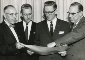
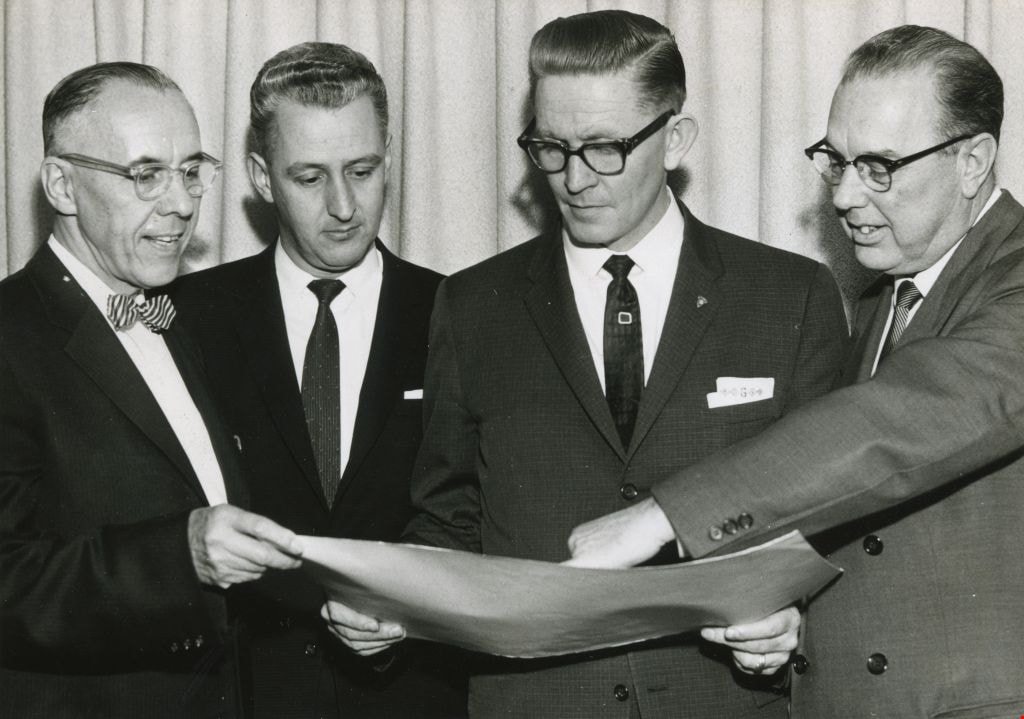
A. A. Shelly, G. P. Woodside, E. R. Loftus, and Harold Balfour
https://search.heritageburnaby.ca/link/archivedescription46132
- Repository
- City of Burnaby Archives
- Date
- 1961, published February 9, 1961
- Collection/Fonds
- Columbian Newspaper collection
- Description Level
- Item
- Physical Description
- 1 photograph : b&w ; 10 x 14 cm
- Scope and Content
- Photograph of vice-president and western general manager of Loblaw Groceterias Co. Ltd. A. A. Shelly, general manager of the Brentwood Shopping Centre Gerald Patrick Woodside, assistant vice-president of Webb & Knapp (Canada) E. R. Loftus, and municipal manager of Burnaby Harold Balfour looking at …
- Repository
- City of Burnaby Archives
- Date
- 1961, published February 9, 1961
- Collection/Fonds
- Columbian Newspaper collection
- Physical Description
- 1 photograph : b&w ; 10 x 14 cm
- Description Level
- Item
- Record No.
- 480-1020
- Access Restriction
- No restrictions
- Reproduction Restriction
- Reproduce for fair dealing purposes only
- Accession Number
- 2003-02
- Scope and Content
- Photograph of vice-president and western general manager of Loblaw Groceterias Co. Ltd. A. A. Shelly, general manager of the Brentwood Shopping Centre Gerald Patrick Woodside, assistant vice-president of Webb & Knapp (Canada) E. R. Loftus, and municipal manager of Burnaby Harold Balfour looking at the plans for Brentwood Shopping centre together.
- Media Type
- Photograph
- Photographer
- Timbrell, Don
- Notes
- Title based on contents of photograph
Images
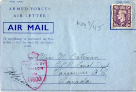
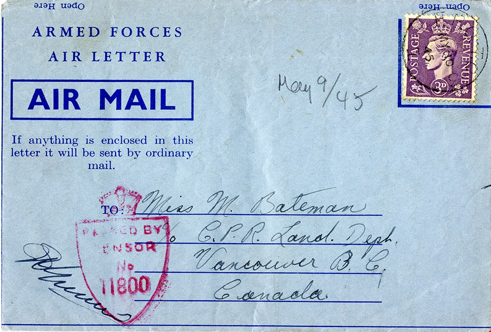
Air mail letter from Colin Fox to May Bateman
https://search.heritageburnaby.ca/link/museumdescription15153
- Repository
- Burnaby Village Museum
- Date
- 9 May 1945
- Collection/Fonds
- E.W. Bateman family fonds
- Description Level
- Item
- Physical Description
- 1 p. (double sided and folded)
- Scope and Content
- Item consists of a handwritten air mail letter from Sergeant Colin Rhodes Fox of the Royal Canadian Artillery Service to his aunt Marianne "May" Bateman while serving overseas during World War II. Colin Fox served in the 13th Canadian Field Regiment with the 44th and 78th Canadian Field Battery. Co…
- Repository
- Burnaby Village Museum
- Collection/Fonds
- E.W. Bateman family fonds
- Description Level
- Item
- Physical Description
- 1 p. (double sided and folded)
- Scope and Content
- Item consists of a handwritten air mail letter from Sergeant Colin Rhodes Fox of the Royal Canadian Artillery Service to his aunt Marianne "May" Bateman while serving overseas during World War II. Colin Fox served in the 13th Canadian Field Regiment with the 44th and 78th Canadian Field Battery. Colin writes his letter from Germany; wishes that he could have been a part of VE day celebrations in Vancouver; tells of how they haven't fired a shot since May 4th and did their celebrating then; how he's been working getting equipment and vehicles cleaned up; how he learned through broadcasts about celebrations in England and he plans on taking his next leave there; he expects that they will tour around Germany until he's released to return home.
- Accession Code
- BV020.27.40
- Access Restriction
- Restricted access
- Reproduction Restriction
- May be restricted by third party rights
- Date
- 9 May 1945
- Media Type
- Textual Record
- Scan Resolution
- 600
- Scan Date
- 10-Feb-2021
- Scale
- 100
- Notes
- Title based on contents of item
- Air mail letter is addressed to: "Miss M. Bateman / c/o C.P.R. Land Dept. / Vancouver B.C. / Canada"
- Circular postmark stamps read: F P O T O 3 / MY 10 / 45"
- Stamp on outside of air mail letter reads: "PASSED BY / CENSOR / No. / 11800"
- Return address on outside of air mail letter reads: "K19022 Sgt. / C.R.Fox"
Images

Alfred & Ruth MacLeod Cottage
https://search.heritageburnaby.ca/link/landmark503
- Repository
- Burnaby Heritage Planning
- Description
- Located atop a hill on the southern shore of picturesque Deer Lake, the Alfred and Ruth MacLeod Cottage is a one and one-half storey, wood-frame, rustic Arts and Crafts-style bungalow. The cottage is well-maintained, but has been altered through the enclosure of much of its original wraparound vera…
- Associated Dates
- 1913
- Repository
- Burnaby Heritage Planning
- Geographic Access
- Deer Lake Drive
- Associated Dates
- 1913
- Description
- Located atop a hill on the southern shore of picturesque Deer Lake, the Alfred and Ruth MacLeod Cottage is a one and one-half storey, wood-frame, rustic Arts and Crafts-style bungalow. The cottage is well-maintained, but has been altered through the enclosure of much of its original wraparound verandah. Its sits on the brow of a steep slope, with panoramic views north to Deer Lake.
- Heritage Value
- The Alfred and Ruth MacLeod Cottage is valued as a significant example of the early development of summer estates in Burnaby, specifically in the Deer Lake neighbourhood, that attracted residents from the burgeoning cities of New Westminster and Vancouver. Access to the area was facilitated by the construction of the Burnaby Lake Interurban tramline, which opened in June 1911. This modest, rustic cottage illustrates the desire for a simple country lifestyle and retreat into nature of those who settled on the south shore of Deer Lake. While the grand mansions on the north shore of Deer Lake are set in formally landscaped gardens, the informality of this cottage demonstrates reverence for its natural, wooded surroundings, oriented towards views of Deer Lake. The Alfred and Ruth MacLeod Cottage is important for its connection with prominent New Westminster insurance and real estate broker, Alfred W. MacLeod, and his wife, Ruth. The MacLeods had recently constructed a large city home, and built this cottage as a summer residence in 1913. In 2005, the Alfred and Ruth MacLeod Cottage was purchased by the City of Burnaby and today constitutes part of the Deer Lake Park Heritage Precinct, which is Burnaby's most significant collection of historic sites.
- Defining Elements
- Key elements that define the heritage character of the Alfred and Ruth MacLeod Cottage include its: - secluded setting on the brow of a steep hill on the southern shore of Deer Lake, with expansive views of Deer Lake to the north - residential form, scale and massing as expressed by its one and one-half storey rectangular plan, side-gabled roof, hipped roof over original verandah and two shed dormers - associated landscape features such as mature coniferous and deciduous trees surrounding the property
- Historic Neighbourhood
- Burnaby Lake (Historic Neighbourhood)
- Planning Study Area
- Morley-Buckingham Area
- Function
- Primary Historic--Single Dwelling
- Primary Current--Single Dwelling
- Cadastral Identifier
- P.I.D.000-708-038
- Boundaries
- The Alfred and Ruth MacLeod Cottage is comprised of a single residential lot located at 6466 Deer Lake Drive, Burnaby.
- Area
- 13354.63
- Contributing Resource
- Building
- Ownership
- Public (local)
- Documentation
- City of Burnaby Planning and Building Department, Heritage Site Files
- Street Address
- 6466 Deer Lake Drive
Images


![All Saints Church, [ca.1910] thumbnail](/media/hpo/_Data/_BVM_Cartographic_Material/2003/2003_0083_0046_001.jpg?width=280)
All Saints Church
https://search.heritageburnaby.ca/link/museumdescription11924
- Repository
- Burnaby Village Museum
- Date
- [ca.1910]
- Collection/Fonds
- Ronald G. Scobbie collection
- Description Level
- Item
- Physical Description
- 1 plan : black ink and watercol. on paper ; 30.45 x 30.5 cm
- Scope and Content
- Item consists of building insurance plan of "All Saints Church / Lot "A" BK 29 DL 98 GP1 N.W.D.". Watling Street is idenfied to the north of the church building and Royal Oak Avenue to the west.
- Repository
- Burnaby Village Museum
- Collection/Fonds
- Ronald G. Scobbie collection
- Description Level
- Item
- Physical Description
- 1 plan : black ink and watercol. on paper ; 30.45 x 30.5 cm
- Material Details
- Scale 1 inch = 20 feet
- Scope and Content
- Item consists of building insurance plan of "All Saints Church / Lot "A" BK 29 DL 98 GP1 N.W.D.". Watling Street is idenfied to the north of the church building and Royal Oak Avenue to the west.
- Subjects
- Buildings - Religious - Churches
- Accession Code
- BV003.83.46
- Access Restriction
- No restrictions
- Reproduction Restriction
- No known restrictions
- Date
- [ca.1910]
- Media Type
- Cartographic Material
- Scan Resolution
- 600
- Scan Date
- 15-Jan-2021
- Scale
- 100
- Notes
- Transcribed title
- Note in pencil on verso reads: ""All Saints Church / Lot "A" BK 29 DL 98 / Scale 1 inch = 20 feet"
- Note in balck in on verso reads: "3704"
Images
![All Saints Church, [ca.1910] thumbnail](/media/hpo/_Data/_BVM_Cartographic_Material/2003/2003_0083_0046_001.jpg)

Andy Johnson House
https://search.heritageburnaby.ca/link/landmark515
- Repository
- Burnaby Heritage Planning
- Description
- The Andy Johnson House is a large, one and one-half storey plus above-ground basement wood-frame mansion on a rubble-stone granite foundation with a red terra cotta pantile roof and an octagonal corner turret. The building stands in a prominent location on a corner lot on Kingsway, one of Burnaby’s…
- Associated Dates
- 1912
- Formal Recognition
- Community Heritage Register
- Other Names
- Andrew M. & Margaret Johnson House 'Glenedward'
- Street View URL
- Google Maps Street View
- Repository
- Burnaby Heritage Planning
- Other Names
- Andrew M. & Margaret Johnson House 'Glenedward'
- Geographic Access
- Kingsway
- Associated Dates
- 1912
- Formal Recognition
- Community Heritage Register
- Enactment Type
- Council Resolution
- Enactment Date
- 26/05/2003
- Description
- The Andy Johnson House is a large, one and one-half storey plus above-ground basement wood-frame mansion on a rubble-stone granite foundation with a red terra cotta pantile roof and an octagonal corner turret. The building stands in a prominent location on a corner lot on Kingsway, one of Burnaby’s main transportation and commercial corridors, and stands adjacent to the Burlington Square Development.
- Heritage Value
- The Andy Johnson House 'Glenedward' is a valued representation of a prominent upper middle-class family dwelling from the pre-First World War era. Andrew M. Johnson (1861-1934), an early Vancouver pioneer, and his wife Margaret built this house in 1912, in an imposing style favoured by the newly wealthy of the prewar boom period. Born in Norway, Andrew Johnson arrived in Vancouver just months after the Great Fire of 1886 and went into partnership with J. (Ollie) Atkins in a transportation company that became the Mainland Transfer Company, eventually the largest of its kind in Vancouver. Johnson also operated Burnaby's historic Royal Oak Hotel, once located on the opposite corner from his estate. Additionally, the Andy Johnson House is significant for the high-quality design and construction of both the house and its landscaped setting. Designed in the British Arts and Crafts style, the house exhibits a rare degree of opulence in building materials, including imported terra cotta roof tiles, oak and walnut interior millwork, and stained glass manufactured by the Royal City Glass Company. The rubble-stone foundations and perimeter walls were obtained from two massive granite glacial erratic boulders found on the property. The house has been relocated closer to the corner, but the encircling stone walls, the gate posts and gates manufactured by the Westminster Iron Works and some of the original plantings have been retained. A grouping of three giant Sequoias, other mature deciduous trees and massings of shrubbery indicate the type of landscape setting considered appropriate for an estate house in the early years of the twentieth century.
- Defining Elements
- Key elements that define the heritage character of the Andy Johnson House include its: - corner location on Kingsway at Royal Oak Avenue - residential form, scale and massing as expressed by the one and one-half storey height, above-ground basement, octagonal corner turret and rectangular plan - British Arts and Crafts details such as the use of natural indigenous materials, half-timbering in the gables and dormers, picturesque roofline, cedar shingle siding, extended eaves, native granite rubble-stone foundation with red-coloured mortar, and granite piers and chimneys - additional exterior features such as the central front entrance, elaborate wrap-around verandah, porte-cochere and balcony at second storey lighted with original cast iron electric lanterns - red terra cotta pantile roof cladding - fenestration, such as double-hung 1-over-1 wooden-sash windows with stained glass and leaded lights in the upper sash - original interior features such as fireplaces, wainscoting finished with oak and walnut millwork, and three-quarter sawn oak flooring - associated landscape features including three giant Sequoias. granite walls, granite gate posts and wrought iron gates
- Historic Neighbourhood
- Central Park (Historic Neighbourhood)
- Planning Study Area
- Marlborough Area
- Builder
- J.C. Allen
- Function
- Primary Historic--Single Dwelling
- Primary Current--Eating or Drinking Establishment
- Community
- Burnaby
- Cadastral Identifier
- 003-004-538
- Boundaries
- The Andy Johnson House is comprised of a single residential lot located at 5152 Kingsway, Burnaby
- Area
- 1424.21
- Contributing Resource
- Building
- Ownership
- Private
- Street Address
- 5152 Kingsway
- Street View URL
- Google Maps Street View
Images


![Anglican Church, [ca.1910] thumbnail](/media/hpo/_Data/_BVM_Cartographic_Material/2003/2003_0083_0043_001.jpg?width=280)
Anglican Church
https://search.heritageburnaby.ca/link/museumdescription11921
- Repository
- Burnaby Village Museum
- Date
- [ca.1910]
- Collection/Fonds
- Ronald G. Scobbie collection
- Description Level
- Item
- Physical Description
- 1 plan : black ink and watercol. on paper ; 30.45 x 30.5 cm
- Scope and Content
- Item consists of building insurance plan of "Anglican Church / Lot 2 BK 37 DL69, GP.1, N.W.D. (15th Ave. (Dominion) is identified to the north of Lots 1, 2 and 3).
- Repository
- Burnaby Village Museum
- Collection/Fonds
- Ronald G. Scobbie collection
- Description Level
- Item
- Physical Description
- 1 plan : black ink and watercol. on paper ; 30.45 x 30.5 cm
- Material Details
- Scale 1 inch = 20 feet
- Scope and Content
- Item consists of building insurance plan of "Anglican Church / Lot 2 BK 37 DL69, GP.1, N.W.D. (15th Ave. (Dominion) is identified to the north of Lots 1, 2 and 3).
- Subjects
- Buildings - Religious - Churches
- Accession Code
- BV003.83.43
- Access Restriction
- No restrictions
- Reproduction Restriction
- No known restrictions
- Date
- [ca.1910]
- Media Type
- Cartographic Material
- Scan Resolution
- 600
- Scan Date
- 15-Jan-2021
- Scale
- 100
- Notes
- Transcribed title
- Note in pencil on verso reads: "Anglican Church / Lot 2 Bk 37 DL69 / 1"=20' "
- Note in balck in on verso reads: "3704"
Images
![Anglican Church, [ca.1910] thumbnail](/media/hpo/_Data/_BVM_Cartographic_Material/2003/2003_0083_0043_001.jpg)

Angus & Margaret MacDonald House
https://search.heritageburnaby.ca/link/landmark495
- Repository
- Burnaby Heritage Planning
- Description
- Set on a large corner lot at North Esmond Avenue and Oxford Street, the Angus & Margaret MacDonald House is a prominent, two and one-half storey Queen Anne Revival-style residence. The high hipped roof has open projecting gables. The house is a landmark within the Vancouver Heights neighbourhood of…
- Associated Dates
- 1909
- Formal Recognition
- Heritage Designation, Community Heritage Register
- Street View URL
- Google Maps Street View
- Repository
- Burnaby Heritage Planning
- Geographic Access
- Oxford Street
- Associated Dates
- 1909
- Formal Recognition
- Heritage Designation, Community Heritage Register
- Enactment Type
- Bylaw No. 12174
- Enactment Date
- 11/12/2006
- Description
- Set on a large corner lot at North Esmond Avenue and Oxford Street, the Angus & Margaret MacDonald House is a prominent, two and one-half storey Queen Anne Revival-style residence. The high hipped roof has open projecting gables. The house is a landmark within the Vancouver Heights neighbourhood of North Burnaby, on a high point of land overlooking Burrard Inlet and the North Shore Mountains.
- Heritage Value
- The MacDonald House is valued as one of Burnaby’s most elaborate examples of the Queen Anne Revival style. The house retains many of its original features, including a prominent front corner turret wrapped by a clamshell verandah. The eclectic and transitional nature of Edwardian-era architecture is demonstrated by the late persistence of these Queen Anne Revival details, combined with the use of newly-popular classical revival elements such as Ionic columns. The interior retains a number of original architectural elements, and the early garage at the rear originally housed Angus MacDonald’s Cadillac, one of the first known automobiles owned by a Burnaby resident. Constructed in 1909, this house was built for Angus MacDonald (1857-1943) and his wife, Margaret Isabella Thompson MacDonald (1862-1939). Angus MacDonald, an electrical contractor, relocated from Nova Scotia to Vancouver in 1891 and served on Vancouver Council from 1904-08. The MacDonald family moved to Burnaby upon his retirement from the B.C. Electric Railway Company, and he then served the North Burnaby Ward as a councillor from 1911-1916 and again in 1921. MacDonald Street in Burnaby was named in his honour. The MacDonald House has additional significance as one of the surviving landmark residences, built between 1909 and 1914, during the first development of Vancouver Heights. In 1909, C.J. Peter and his employer, G.F. and J. Galt Limited, initiated the development of this North Burnaby neighbourhood, promoting it as one of the most picturesque districts in the region and an alternative to the CPR’s prestigious Shaughnessy Heights development in Vancouver. Buyers were obligated to build houses worth $3,500 at a time when the average house price was $1,000. Reputed to be the second house built in the subdivision, this house cost $7,000 to build.
- Defining Elements
- Key elements that define the heritage character of the MacDonald House include its: - prominent corner location in the Vancouver Heights neighbourhood, with views to Burrard Inlet and the North Shore Mountains - residential form, scale and massing as exemplified by its two and one-half storey height, full basement, compound plan, and high hipped roof with gabled projections at the front and side - wood-frame construction including wooden lapped siding, trim and mouldings - rubble-stone granite foundation - Queen Anne Revival details such as scroll-cut modillions, octagonal corner turret, wraparound, clamshell verandah with classical columns, and projecting square and semi-octagonal bays - external red-brick chimney with corbelled top - original windows including double-hung, 1-over-1 wooden sash windows in single and double assembly, and arched-top casement windows in the gable peaks - original interior features such as the main staircase, a panelled dining room with a fireplace and built-in cabinets, a living room with a parquet floor, and a rear den with an oak mantle and tiled hearth - associated early wood-frame garage at the rear of the property - landscape features such as mature coniferous and deciduous trees surrounding the property
- Historic Neighbourhood
- Vancouver Heights (Historic Neighbourhood)
- Planning Study Area
- Burnaby Heights Area
- Organization
- British Columbia Mills Timber and Trading Company
- Function
- Primary Historic--Single Dwelling
- Primary Current--Single Dwelling
- Community
- Vancouver Heights
- Cadastral Identifier
- P.I.D.011-999-462
- Boundaries
- The MacDonald House is comprised of a single residential lot located at 3814 Oxford Street, Burnaby.
- Area
- 566.71
- Contributing Resource
- Building
- Ownership
- Private
- Documentation
- City of Burnaby Planning and Building Department, Heritage Site Files
- Street Address
- 3814 Oxford Street
- Street View URL
- Google Maps Street View
Images


Armstrong, Lyle - Burnaby Planning Director
https://search.heritageburnaby.ca/link/archivedescription58828
- Repository
- City of Burnaby Archives
- Date
- 1973
- Collection/Fonds
- Columbian Newspaper collection
- Description Level
- Item
- Physical Description
- 1 photograph : b&w ; 8 x 5 cm
- Scope and Content
- Photograph of Lyle Armstrong, Burnaby Planning Director.
- Repository
- City of Burnaby Archives
- Date
- 1973
- Collection/Fonds
- Columbian Newspaper collection
- Physical Description
- 1 photograph : b&w ; 8 x 5 cm
- Description Level
- Item
- Record No.
- 480-1289
- Access Restriction
- No restrictions
- Reproduction Restriction
- Reproduce for fair dealing purposes only
- Accession Number
- 2009-01
- Scope and Content
- Photograph of Lyle Armstrong, Burnaby Planning Director.
- Names
- Armstrong, Lyle
- Media Type
- Photograph
- Notes
- Title based on contents of photograph
Images

Armstrong Street School site
https://search.heritageburnaby.ca/link/museumdescription11133
- Repository
- Burnaby Village Museum
- Date
- 1915
- Collection/Fonds
- Ronald G. Scobbie collection
- Description Level
- Item
- Physical Description
- 1 survey plan : blueprint on paper ; 56 x 54 cm
- Scope and Content
- Survey plan of "Armstrong Street School Site / Burnaby Municipality" "Being a 2 acre portion of Lot 13 Group 1, & according to map 1722 which shows this as Lot E. Block 2 of subdivision of a portion, of Lot 13, Group 1, New Westminster District".
- Repository
- Burnaby Village Museum
- Collection/Fonds
- Ronald G. Scobbie collection
- Description Level
- Item
- Physical Description
- 1 survey plan : blueprint on paper ; 56 x 54 cm
- Material Details
- Scale 40 feet = 1 inch
- Scope and Content
- Survey plan of "Armstrong Street School Site / Burnaby Municipality" "Being a 2 acre portion of Lot 13 Group 1, & according to map 1722 which shows this as Lot E. Block 2 of subdivision of a portion, of Lot 13, Group 1, New Westminster District".
- Creator
- Burnett, Geoffrey K.
- Subjects
- Buildings - Schools
- Names
- Armstrong Avenue School
- Responsibility
- Burnett & McGugan, Engineers and Surveyors
- Geographic Access
- Armstrong Avenue
- Street Address
- 8757 Armstrong Avenue
- Accession Code
- BV003.83.12
- Access Restriction
- No restrictions
- Reproduction Restriction
- No known restrictions
- Date
- 1915
- Media Type
- Cartographic Material
- Historic Neighbourhood
- East Burnaby (Historic Neighbourhood)
- Planning Study Area
- Cariboo-Armstrong Area
- Scan Resolution
- 440
- Scan Date
- 22-Dec-2020
- Scale
- 100
- Notes
- Title based on contents of plan
- Note in black ink on verso of plan reads: "1746"
- Oath on plan reads: "I, Geoffrey K. Burnett...and did personally superintend the survey represented..." "Completed on the 18th day of March 1915"; signed by Geoffrey K. Burnett and notarized by "K.A. Eastman", sworn "...19th day of April 1915"; "Burnett and McGugan., B.C. Land Surveyors. Etc.. New Westminster, B.C.."
Zoomable Images


Barnet mill
https://search.heritageburnaby.ca/link/museumdescription15219
- Repository
- Burnaby Village Museum
- Date
- 1934 (date of original), copied 2004
- Collection/Fonds
- In the Shadow by the Sea collection
- Description Level
- Item
- Physical Description
- 1 photograph (tiff) : 300 dpi
- Scope and Content
- Photograph of the Barnet Mill on the shore of Burrard Inlet. Mill buildings including lodgings are visible.
- Repository
- Burnaby Village Museum
- Collection/Fonds
- In the Shadow by the Sea collection
- Description Level
- Item
- Physical Description
- 1 photograph (tiff) : 300 dpi
- Scope and Content
- Photograph of the Barnet Mill on the shore of Burrard Inlet. Mill buildings including lodgings are visible.
- Names
- Barnet Mill
- Geographic Access
- Burrard Inlet
- Accession Code
- BV019.32.39
- Access Restriction
- No restrictions
- Reproduction Restriction
- No known restrictions
- Date
- 1934 (date of original), copied 2004
- Media Type
- Photograph
- Historic Neighbourhood
- Barnet (Historic Neighbourhood)
- Planning Study Area
- Burnaby Mountain Area
- Notes
- Title based on contents of photograph
- Historical information provided by Burnaby Heritage Planning - Barnet Neighbourhood
Images


Barnet mill burner
https://search.heritageburnaby.ca/link/museumdescription15221
- Repository
- Burnaby Village Museum
- Date
- 1937 (date of original), copied 2004
- Collection/Fonds
- In the Shadow by the Sea collection
- Description Level
- Item
- Physical Description
- 1 photograph (tiff) : 300 dpi
- Scope and Content
- Photograph of the site of the old Barnet Mill burner along the shore of Burrard Inlet. Pilings and rail tracks are visible along the shore. B.C. Electric transmisson towers are visible at the top of the site. Photograph is taken from the water looking south.
- Repository
- Burnaby Village Museum
- Collection/Fonds
- In the Shadow by the Sea collection
- Description Level
- Item
- Physical Description
- 1 photograph (tiff) : 300 dpi
- Scope and Content
- Photograph of the site of the old Barnet Mill burner along the shore of Burrard Inlet. Pilings and rail tracks are visible along the shore. B.C. Electric transmisson towers are visible at the top of the site. Photograph is taken from the water looking south.
- Names
- Barnet Mill
- Geographic Access
- Burrard Inlet
- Accession Code
- BV019.32.41
- Access Restriction
- No restrictions
- Reproduction Restriction
- No known restrictions
- Date
- 1937 (date of original), copied 2004
- Media Type
- Photograph
- Historic Neighbourhood
- Barnet (Historic Neighbourhood)
- Planning Study Area
- Burnaby Mountain Area
- Notes
- Title based on contents of photograph
- Historical information provided by Burnaby Heritage Planning - Barnet Neighbourhood
Images


Barnet School site
https://search.heritageburnaby.ca/link/museumdescription11140
- Repository
- Burnaby Village Museum
- Date
- May 27, 1915
- Collection/Fonds
- Ronald G. Scobbie collection
- Description Level
- Item
- Physical Description
- 1 survey plan : blueprint on paper ; 56 x 54 cm
- Scope and Content
- Survey plan of "Barnet School Site / Burnaby Municipality" "Being a portion of the west half of lot / 214, Group 1 / New Westminster District”.
- Repository
- Burnaby Village Museum
- Collection/Fonds
- Ronald G. Scobbie collection
- Description Level
- Item
- Physical Description
- 1 survey plan : blueprint on paper ; 56 x 54 cm
- Material Details
- Scale 40 feet = 1 inch
- Scope and Content
- Survey plan of "Barnet School Site / Burnaby Municipality" "Being a portion of the west half of lot / 214, Group 1 / New Westminster District”.
- Creator
- McGugan, Donald Johnston
- Subjects
- Buildings - Schools
- Names
- Barnet School
- Responsibility
- Burnett & McGugan, Engineers and Surveyors
- Geographic Access
- Barnet Road
- Street Address
- 7820 Barnet Road
- Accession Code
- BV003.83.19
- Access Restriction
- No restrictions
- Reproduction Restriction
- No known restrictions
- Date
- May 27, 1915
- Media Type
- Cartographic Material
- Historic Neighbourhood
- Barnet (Historic Neighbourhood)
- Planning Study Area
- Burnaby Mountain Area
- Scan Resolution
- 440
- Scan Date
- 22-Dec-2020
- Scale
- 100
- Notes
- Title based on contents of plan
- handwritten on back "Burnaby Schools" "23R" twice, "1783"
- Oath on plan reads: "I, D.J. McGugan...and did personally superintend the survey..." "completed on the 27th day of May 1915"; signed by D.J. McGugan, notarized by "Walter Edmonds" "sworn "...29th day of May 1915" "Burnett and McGugan" "B.C. Land Surveyors Etc. New Westminster, B.C.";
Zoomable Images

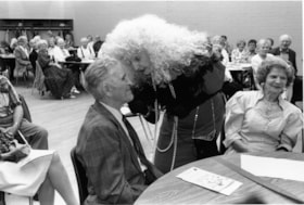
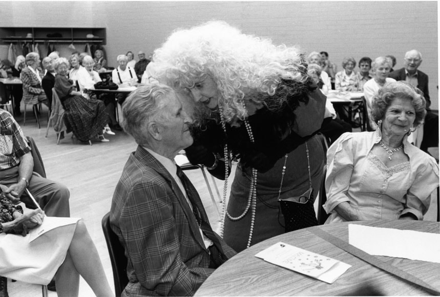
Betty Armour
https://search.heritageburnaby.ca/link/archivedescription81027
- Repository
- City of Burnaby Archives
- Date
- May 13, 1998
- Collection/Fonds
- Burnaby NewsLeader photograph collection
- Description Level
- Item
- Physical Description
- 1 photograph : b&w ; 15 x 22.5 cm
- Scope and Content
- Photograph of Betty Armour leaning over an audience member at Edmonds Community Centre for Older Adults during her performance.
- Repository
- City of Burnaby Archives
- Date
- May 13, 1998
- Collection/Fonds
- Burnaby NewsLeader photograph collection
- Physical Description
- 1 photograph : b&w ; 15 x 22.5 cm
- Description Level
- Item
- Record No.
- 535-1197
- Access Restriction
- No restrictions
- Reproduction Restriction
- No reproduction permitted
- Accession Number
- 2012-11
- Scope and Content
- Photograph of Betty Armour leaning over an audience member at Edmonds Community Centre for Older Adults during her performance.
- Names
- Armour, Betty
- Media Type
- Photograph
- Photographer
- Ray, Steve
- Notes
- Title based on contents of photograph
- Note in black ink on recto of photograph reads: "1017 Bby Steve / 76% Bby p 3"
- Trim marks and/or reproduction instructions on recto (scan is cropped)
- Accompanying caption reads: "May 13, 1998 1017: / Betty Armour comes off stage to tease Aurthus Norby and have some fun with the audience at the Edmunds [sic] Community Centre for Older Adults last week. The event was also a fundraiser for a planned fitness."
Images
![BFG bag prop concept plan, [2015] thumbnail](/media/hpo/_Data/_BVM_Images/2022/2022_0021_0100_001.jpg?width=280)
BFG bag prop concept plan
https://search.heritageburnaby.ca/link/museumdescription19155
- Repository
- Burnaby Village Museum
- Date
- [2015]
- Collection/Fonds
- Hipman "Jimmy" Chow and Donna Polos fonds
- Description Level
- Item
- Physical Description
- 1 photograph : col. laser print ; 28 x 43.5 cm with annotations
- Scope and Content
- Item consists of a concept plan created by concept illustrator Brian Cunningham for a leather bag to be used as a prop in the film "The BFG". Ovelay of tape with actual measurements on surface of print for the creation of the leather bag. Concept plan was used by property master, Jimmy Chow to crea…
- Repository
- Burnaby Village Museum
- Collection/Fonds
- Hipman "Jimmy" Chow and Donna Polos fonds
- Description Level
- Item
- Physical Description
- 1 photograph : col. laser print ; 28 x 43.5 cm with annotations
- Material Details
- Green masking tape and white duct tape adhered to surface of print
- Handwritten measurements in black ink written on surface of tape
- Scope and Content
- Item consists of a concept plan created by concept illustrator Brian Cunningham for a leather bag to be used as a prop in the film "The BFG". Ovelay of tape with actual measurements on surface of print for the creation of the leather bag. Concept plan was used by property master, Jimmy Chow to create the bag as a prop. The film was directed by Steven Spielberg and released in 2016.
- Creator
- Cunningham, Brian
- Subjects
- Industries - Film
- Responsibility
- Beach, Chris
- Accession Code
- BV022.21.100
- Access Restriction
- No restrictions
- Reproduction Restriction
- May be restricted by third party rights
- Date
- [2015]
- Media Type
- Graphic Material
- Notes
- Title based on contents of item
- Bottom right corner includes identifiers reading: "? / ...BFG 3 BAG_PROP CONCEPT / ... PROP BFG BAG CONCEPT / .../ Scale / 15:00:00 [sic] / ? / C_BEACH /? / B_CUNNINGHAM / ? / NONE [sic] / ? / PRP_C05 / ..."
- Drawing identifies, Brian Cunningham as concept illustrator and Chris Beach as [designer] (Art Director)
Images
![BFG bag prop concept plan, [2015] thumbnail](/media/hpo/_Data/_BVM_Images/2022/2022_0021_0100_001.jpg)

Big Bend Neighbourhood
https://search.heritageburnaby.ca/link/landmark840
- Repository
- Burnaby Heritage Planning
- Associated Dates
- 1955-2008
- Heritage Value
- The Big Bend Neighbourhood in Burnaby maintained its status as an important agricultural area in the City in the years following 1955 and it also solidified its role as a prime industrial and commercial district. In 1972, the Big Bend Development Plan was adopted by Council and soon thereafter, approximately 620 acres of land were incorporated into the Agricultural Land Reserve. These lands have been set aside for agricultural and limited recreation purposes. By the 2000s, 160 acres of land were considered highly productive agricultural areas, and over 400 acres of land had been secured as parkland, including the Fraser Foreshore Park. The area also developed large commercial and industrial districts including those at Marine Way/Boundary, the Glenlyon Estates, Riverfront Business Park, Burnaby Business Park, and Glenwood Industrial Estates.
- Historic Neighbourhood
- Fraser Arm (Historic Neighbourhood)
- Planning Study Area
- Big Bend Area
Images

![Bill Blakely, [between 1954 and 1956] thumbnail](/media/Hpo/_Data/_Archives_Images/_Unrestricted/480/480-1554.jpg?width=280)
Bill Blakely
https://search.heritageburnaby.ca/link/archivedescription64827
- Repository
- City of Burnaby Archives
- Date
- [between 1954 and 1956]
- Collection/Fonds
- Columbian Newspaper collection
- Description Level
- Item
- Physical Description
- 1 photograph : b&w ; 8 x 5.5 cm
- Scope and Content
- Photograph of Burnaby Planning Engineer, William (Bill) Blakely.
- Repository
- City of Burnaby Archives
- Date
- [between 1954 and 1956]
- Collection/Fonds
- Columbian Newspaper collection
- Physical Description
- 1 photograph : b&w ; 8 x 5.5 cm
- Description Level
- Item
- Record No.
- 480-1554
- Access Restriction
- No restrictions
- Reproduction Restriction
- Reproduce for fair dealing purposes only
- Accession Number
- 2003-02
- Scope and Content
- Photograph of Burnaby Planning Engineer, William (Bill) Blakely.
- Names
- Blakely, William "Bill"
- Media Type
- Photograph
- Notes
- Title based on contents of photograph
- Note on verso reads: "W. "Bill" Blakeley / Burnaby"
Images
![Bill Blakely, [between 1954 and 1956] thumbnail](/media/Hpo/_Data/_Archives_Images/_Unrestricted/480/480-1554.jpg)
![Bill Blakely, [between 1954 and 1956] thumbnail](/media/Hpo/_Data/_Archives_Images/_Unrestricted/480/480-1555.jpg?width=280)
Bill Blakely
https://search.heritageburnaby.ca/link/archivedescription64828
- Repository
- City of Burnaby Archives
- Date
- [between 1954 and 1956]
- Collection/Fonds
- Columbian Newspaper collection
- Description Level
- Item
- Physical Description
- 1 photograph : b&w ; 15 x 9.5 cm
- Scope and Content
- Photograph of Burnaby Planning Engineer, William (Bill) Blakely.
- Repository
- City of Burnaby Archives
- Date
- [between 1954 and 1956]
- Collection/Fonds
- Columbian Newspaper collection
- Physical Description
- 1 photograph : b&w ; 15 x 9.5 cm
- Description Level
- Item
- Record No.
- 480-1555
- Access Restriction
- No restrictions
- Reproduction Restriction
- Reproduce for fair dealing purposes only
- Accession Number
- 2003-02
- Scope and Content
- Photograph of Burnaby Planning Engineer, William (Bill) Blakely.
- Names
- Blakely, William "Bill"
- Media Type
- Photograph
- Notes
- Title based on contents of photograph
- Note on verso reads: "Bill Blakely / Burnaby / planning engineer"
Images
![Bill Blakely, [between 1954 and 1956] thumbnail](/media/Hpo/_Data/_Archives_Images/_Unrestricted/480/480-1555.jpg)

Bill Copeland Sports Centre & Burnaby Lake Arena
https://search.heritageburnaby.ca/link/landmark819
- Repository
- Burnaby Heritage Planning
- Geographic Access
- Kensington Avenue
- Associated Dates
- 1965
- Heritage Value
- In February 1965, the Planning Department presented to Burnaby Council a preliminary Development Plan entitled "Pacific Sports Centre," for the area immediately west of Burnaby Lake. This report proposed a conceptual plan for a comprehensive range of indoor and outdoor sporting facilities adjacent to Burnaby Lake. The idea was accepted by Council and led to the construction of the Burnaby Lake Rink beside the C.G. Brown Pool. In 1973, Burnaby and New Westminster jointly hosted the Canada Summer Games for which a rowing course and pavilion were built at Burnaby Lake and the success of the games and the sports facilities added within Burnaby Lake Park provided further stimulus for the creation of the sports and recreation facilities at this site.
- Historic Neighbourhood
- Burnaby Lake (Historic Neighbourhood)
- Planning Study Area
- Ardingley-Sprott Area
- Street Address
- 3676 Kensington Avenue
- Street View URL
- Google Maps Street View
Images
