Narrow Results By
Subject
- Agriculture - Farms 1
- Arts - Drawings 1
- Arts - Sculptures 1
- Building Components 2
- Buildings - Commercial - Grocery Stores 1
- Buildings - Heritage 1
- Buildings - Residential - Houses 1
- Buildings - Schools 1
- Celebrations 1
- Ceremonies - Awards 1
- Construction Tools and Equipment 1
- Corporations - Private Corporations 1

program
https://search.heritageburnaby.ca/link/museumartifact4172
- Repository
- Burnaby Village Museum
- Accession Code
- BV988.44.67
- Description
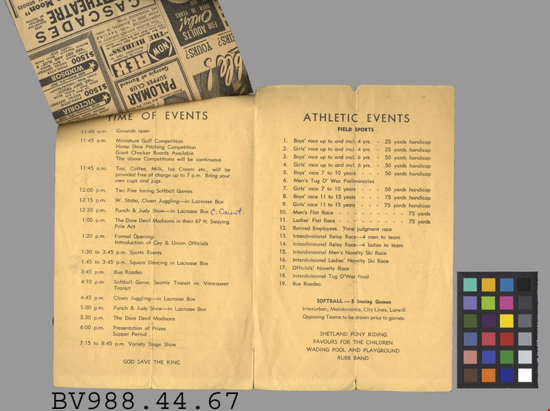
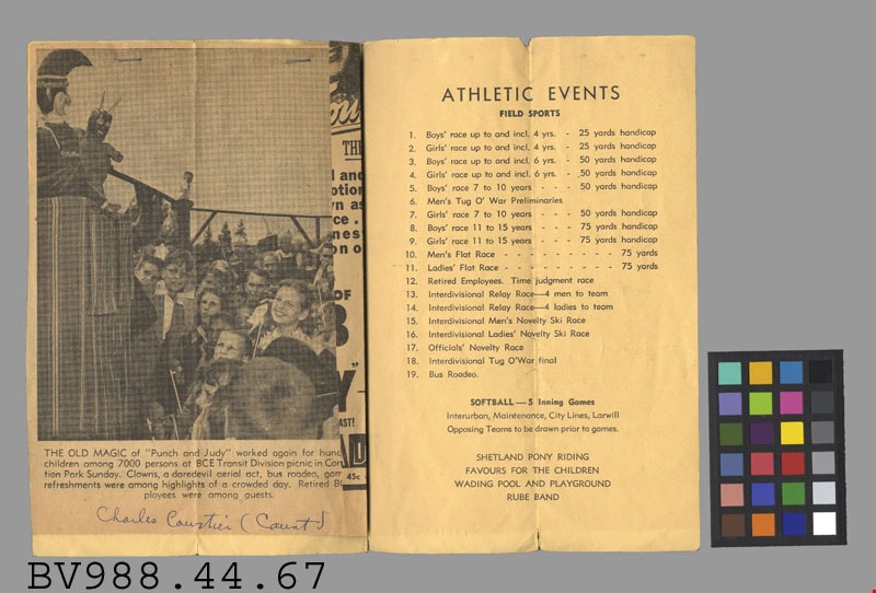
- Transportation Division - Program -- [1950]. Program for the August 6th, 1950 B.C.E.R. and B.C.M.T. picnic for the Transportation Division, All Departments. The picnic was planned at Confederation Park in North Burnaby and started at 11am. The program included the Time of Events along with the Athletic Events of the day. The picnic also advertised Shetland Pony Riding, Favours for the Children, Wading Pool and Playground, and a Rube Band. The back page of the program lists the people involved in the Picnic Committees. Attached to the program with two staples is a newspaper clipping that covered the days events, including mention of "Punch and Judy" which was a puppet show performed by C.Caunt. The program measures 14cm x 21.5cm.
- Colour
- Beige
- Subjects
- Documentary Artifacts
- Documentary Artifacts - Leaflets
- Documentary Artifacts - Newspapers
- Transportation
Images


certificate
https://search.heritageburnaby.ca/link/museumartifact17055
- Repository
- Burnaby Village Museum
- Accession Code
- HV980.37.2
- Description
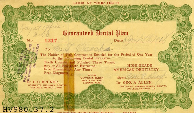
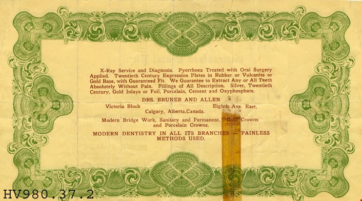
- Guaranteed Dental Plan - Certificate -- [1918]. Dental plan certificate for Mrs. T. Osecki-? which entitled her to a year of dentistry work including teeth cleaning and polishing three times a year, extraction of bad teeth, free examination and diagnosis. The certificate cost $2.50. The Dental Office was in Calgary, Alberta.
- Subjects
- Documentary Artifacts
- Documentary Artifacts - Certificates
- Occupations
- Occupations - Dentists
Images
pamphlet
https://search.heritageburnaby.ca/link/museumartifact26050
- Repository
- Burnaby Village Museum
- Accession Code
- HV975.126.23
- Description
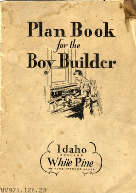
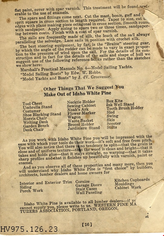
- Plan Book for the Boy Builder - Pamphlet. Buff coloured pamphlet with black print. There is an illustration of boy at workbench under window on the front cover. This pamphlet provided detailed plans on different woodworking projects for young boys. The pamphlet was produced in Portland, Oregon by the Western Pine Manufacturers Association.
Images

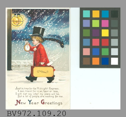
postcard; greeting card
https://search.heritageburnaby.ca/link/museumartifact32320
- Repository
- Burnaby Village Museum
- Accession Code
- HV972.109.20
- Description
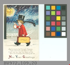
- Postcard, greeting card; embossed, white border, vertical; coloured illustration by Ellen H. Clapsaddle of boy in top hat, red coat, carrying suitcase and looking at large pocket watch which shows 12 o'clock; at train station, train approaching in background, night, snowing; copyright 1911; below in black, "Just in time for the Midnight Express, I can travel far in an hour or less, I will not say what my plans will be, But a lot of people are waiting for me. New Year Greetings"; on reverse in grey, "POST CARD"; double line down centre, at left "FOR CORRESPONDENCE", at right "FOR ADDRESS ONLY"; up left edge, "Series No. 2932"; globe logo "International Art Publ. Co." "NEW.YORK BERLIN" "PRINTED IN GERMANY"; dotted outline of rectangle at upper right, "PLACE A POSTAGE STAMP HERE."; all across card in brown ink, "Dear Francis Jack & Danny thank you for the cards. & they wish you a Happy New Year. how are getting along with the Piano. Lovingly Lena Talbot"; corners are worn; "109.20" in ink at lower right
- Classification
- Written Communication T&E - - Writing Media
- Object Term
- Postcard
- Country Made
- Germany
- Site/City Made
- Berlin
- Patent Date
- 1911
- Title
- New Year Greetings
Images

sales brochure
https://search.heritageburnaby.ca/link/museumartifact80118
- Repository
- Burnaby Village Museum
- Accession Code
- BV008.19.18
- Description
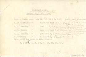
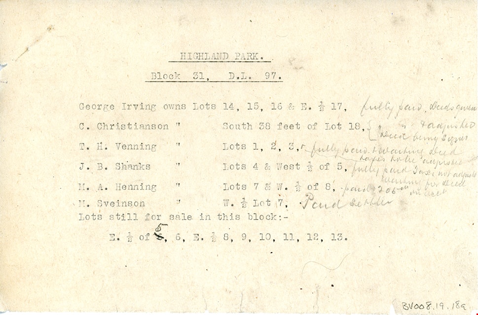
- Land sales brochure, cream paper, black and red print; "WHY TO BUY IN HIGHLANDS" "CHOICE RESIDENTIAL SITES CLEARED" "SUBDIVISION AND PRICE LIST OF" "BLOCKS 31 and 32. DISTRICT LOT 97, situated at the JUNCTION OF THE NEW CUT=OFF ON THE B.C. ELECTRIC TRAM LINE TO NEW WESTMINSTER"; "KEY MAP" of DL97 showing subdivisions of L.25, 26, 31, 32, 33, Vancouver and New Westminster Rd., Buller Rd., B.C.E.R. line, with Royal Oak, Highland Park, and Gillie [sic] Stations, cut-off, Roberts Rd., White Rd.; Group I New Westminster Dist.; terms; "TRUSTEE CO., Limited" "318 HOMER ST. VANCOUVER" "Phone Seymour 883"; description "... magnificent view..."; price list for subdivisions of Bl.31 (cleared) and 32 (uncleared); and "Plan Shewing..." with enlarged view, focusing on lots at White Rd., Buller Rd., roads and allowances; names and resubdivisions drawn on this plan with red ink, pencilled directions and additions; this area was known as the Highlands or Highland Park; 17" x 14"; folded in half to 8.5" X 14"; with an 8.5" x 5.25" piece of note paper pinned to brochure, typed listing of properties and buyers for block 31; notes as to payment and deeds given are handwritten in pencil and match names handwritten on plan itself: George Irving, C. Christianson, T.H. Venning, J.B. Shanks, M.A. Henning, M. Sveinson; soiled; small tears at edges
- Object History
- The Highland Park sub-division in District Lot 97, was in part a real estate development by the company owned by the Thomson family. James and Melville P. Thomson, owned and operated "Thomson Bros." They had extensive property interests in Vancouver and Burnaby and owned and operated a book selling and stationery business in Vancouver.
- Category
- 08. Communication Artifacts
- Classification
- Advertising Media
- Object Term
- Brochure
- Marks/Labels
- "HIGHLANDS / Subdividion of Blocks 31 and 32, District Lot 97 / BURNABY / PRICE LIST / . . . . / TRUSTEE CO., Limited / 318 HOMER ST. Phone Sey. 883 VANCOUVER, B.C.
- Colour
- Cream
- Country Made
- Canada
- Province Made
- British Columbia
- Site/City Made
- Vancouver
- Title
- Subdivision and Price List of Blocks 31 and 32 District Lot 97 New Westminster District
- Historic Neighbourhood
- Highland Park (Historic Neighbourhood)
Images


booklet
https://search.heritageburnaby.ca/link/museumartifact90323
- Repository
- Burnaby Village Museum
- Accession Code
- BV020.8.11
- Description
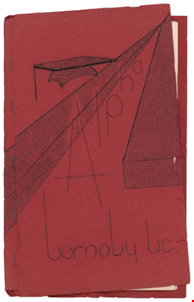
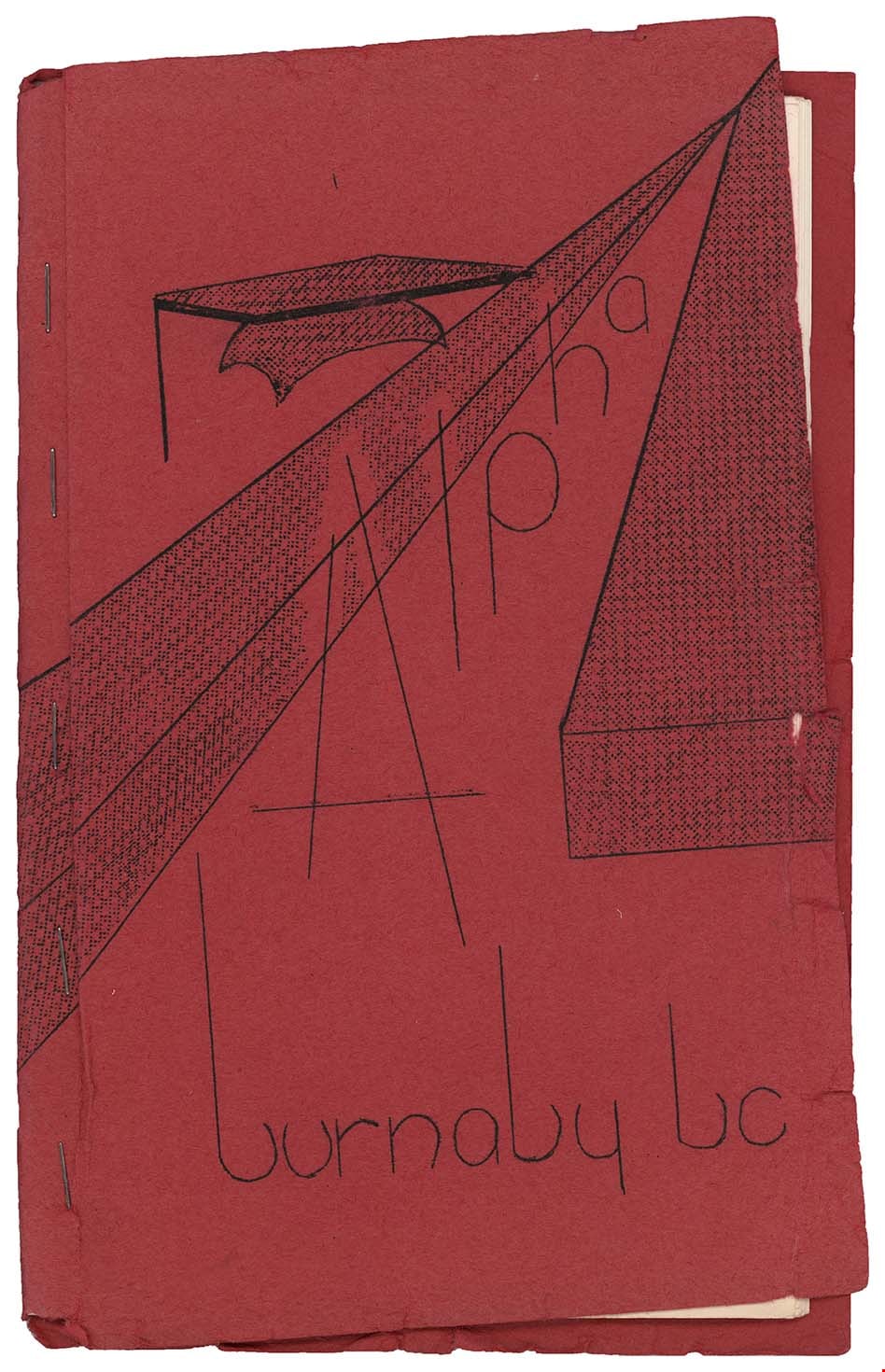
- Booklet; school handbook; red paper cover folded around 17 typewritten pages of cartridge paper with 5 metal staples; front cover reads "Alpha / burnaby bc". Second page inside reads: "Alpha / Junior Secondary / School / Handbook". Includes index on page 5; pages numbered 5 to 29; pull out floor plan of "Alpha Junior Secondary School" on blue paper in back of booklet. Handwritten annotations on first page
- Object History
- Donor attended Alpha Junior Secondary School.
- Category
- 08. Communication Artifacts
- Classification
- Documentary Artifacts - - Other Documents
- Object Term
- Book, Instruction
- Marks/Labels
- Alpha Junior Secondary School
- Measurements
- 23 x 15 cm
- Country Made
- Canada
- Province Made
- British Columbia
- Site/City Made
- Burnaby
- Title
- Alpha burnaby bc
- Publication Date
- [c. 1956]
- Names
- Alpha Secondary School
- Historic Neighbourhood
- Vancouver Heights (Historic Neighbourhood)
- Planning Study Area
- Burnaby Heights Area
Images
leaflet
https://search.heritageburnaby.ca/link/museumartifact90328
- Repository
- Burnaby Village Museum
- Accession Code
- BV005.54.867
- Description
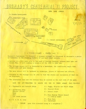
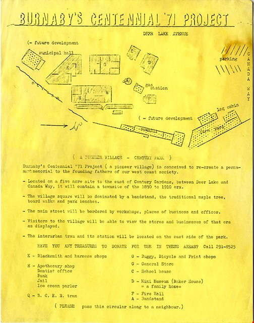
- leaflet; single sheet; photocopy in black ink on yellow cartridge paper; single sided; Title text reads: "BURNABY'S CENTENNIAL '71 PROJECT"; includes a site plan at top identifying buildings for future development; text below reads: "( A PIONEER VILLAGE - CENTURY PARK )" "Burnaby's Centennial '71 Project ( a pioneer village) is conceived to re-create a perma- / nent memorial to the founding fathers of our west coast society.."; "HAVE YOU ANY TREASURES TO DONATE FOR USE IN THESE AREAS? Call 291-8525"; text at bottom reads: "( PLEASE pass this circular along to a neighbour.)"
- Object History
- Part of records found with Don Copan album
- Don Copan was an active member of the Burnaby Centennial ’71 Committee and later became the founding President of the Century Park Museum Association. While a member of the Burnaby Centennial ’71 Committee, Don created a scrapbook album of photographs and ephemera documenting the Burnaby Centennial ’71 Committee’s involvement in celebrating British Columbia’s Centenary of Confederation between January and December 1971 including Burnaby’s Commemorative Project – Heritage Village (Burnaby Village Museum).
- Reference
- Photographs from the Don Copan scrapbook/album are described as part of the Donald Copan collection - Copan Album series
- Category
- 08. Communication Artifacts
- Classification
- Documentary Artifacts - - Other Documents
- Object Term
- Leaflet
- Measurements
- 28 x 21.5 cm
- Country Made
- Canada
- Province Made
- British Columbia
- Title
- Burnaby's Centennial '71 Project
- Publication Date
- [1971]
Images

Lettering Guide
https://search.heritageburnaby.ca/link/museumartifact90811
- Repository
- Burnaby Village Museum
- Accession Code
- BV020.40.2
- Description
- Wooden box with a hinged lid and base with slats for rules and holes for lettering tips. The box contains lettering materials, including white rulers,ink pens in green cardboard cylindrical tubes, guiding stencils for lettering in different fonts, metal tool to hold ink nibs.
- Object History
- This lettering guide was used in the City of Burnaby's Planning Department, in the late 1950s. A lettering guide template is a special type of template used to write uniform characters. It consists of a sheet of plastic or other material with cut-outs of letters, numbers, and other shapes used especially for creating technical drawings. For decades they have been essential for lettering a drawing nameplate so text and other designs could be made quickly and uniformly. Although they have been superseded by the use of computers, during the greater part of the last century they were used to relatively ease the lettering process in the creation of technical drawings. They were an indispensable tool for architects and technical illustrators.
- Classification
- Written Communication T&E - - Writing Devices
- Object Term
- Guide, Lettering
- Marks/Labels
- WRICO LETTERING PEN
- Maker
- WRICO
- Subjects
- Construction Tools and Equipment
- Documentary Artifacts - Architectural Drawings
- Government - Local Government
- Land - Land Surveying
- Occupations - Civic Workers
- Historic Neighbourhood
- Burnaby Lake (Historic Neighbourhood)
- Planning Study Area
- Douglas-Gilpin Area
Images


Ink
https://search.heritageburnaby.ca/link/museumartifact90812
- Repository
- Burnaby Village Museum
- Accession Code
- BV020.40.3
- Description
- Glass bottle of black ink, with a plastic textured lid. The front label is yellow with a gold border, and a blue band along the bottom of the label. It has a black ink stain down the front. The back label is smaller and lighter colour with a yellow stain that reaches to the middle of the label.
- Object History
- This ink came along with a lettering guide used in the City of Burnaby's Planning Department, in the late 1950s. See also BV020.40.2
- Classification
- Written Communication T&E - - Writing Accessories
- Object Term
- Ink
- Marks/Labels
- Chin-Chin waterproof Liquid PearlInk / Sole Canadian Distributors / Made in Germany / Protect from Freezing
- Colour
- Black
- Yellow
- Blue
- Measurements
- 30cm high
- Maker
- PearlInk
- Subjects
- Documentary Artifacts - Architectural Drawings
- Government - Local Government
- Land - Land Surveying
- Occupations - Civic Workers
- Planning - City Planning
- Historic Neighbourhood
- Burnaby Lake (Historic Neighbourhood)
- Planning Study Area
- Douglas-Gilpin Area
Images

Glass Sculpture
https://search.heritageburnaby.ca/link/museumartifact90817
- Repository
- Burnaby Village Museum
- Accession Code
- BV020.40.8
- Description
- Glass rectangular prism with 3D etching depicting heavy duty trucks. Each corner of the bottom of the sculpture has a small pad. The sculpture has a branded black box for safe carrying. The box is in two parts. The exterior of both parts is covered in a black vinyl wrap, and polyester satin in the inside. The inside of each box is inset to fit on half of the sculpture. The top half of the box has a "Burnco 100 Years" logo in red, gray, white and black.
- Object History
- The Burnco company was established in Calgary in 1912 as a rock and aggregate and concrete supply company. This presentation piece was presented to the City of Burnaby on the establishment of its new Burnaby based plant in the Big Bend area in 2004.
- Category
- 08. Communication Artifacts
- Classification
- Ceremonial Artifacts
- Object Term
- Sculpture
- Marks/Labels
- BURNCO 100 YEARS
- Colour
- Red
- Gray
- White
- Black
- Subjects
- Arts - Sculptures
- Corporations - Private Corporations
- Industries
- Natural Resources - Mineral Resources
- Planning - City Planning
- Historic Neighbourhood
- Fraser Arm (Historic Neighbourhood)
- Planning Study Area
- Big Bend Area
Images

Trophy
https://search.heritageburnaby.ca/link/museumartifact90819
- Repository
- Burnaby Village Museum
- Accession Code
- BV020.40.10
- Description
- Maroon brick mounted to a brown varnished wooden stand. On one long edge of the wooden stand is a black plaque with gold letteres reads: OAKALLA 1915 / THE OAKLANDS / Urban Development Institute Award - 1996
- Object History
- This was awarded to the City of Burnaby Planning Department by the Urban Development Institute in 1996 for the redevlopment of the lands which were Oakalla Provincial Prison from 1915-1991.
- Category
- 08. Communication Artifacts
- Classification
- Personal Symbols - - Achievement Symbols
- Object Term
- Trophy
- Colour
- Maroon
- Brown
- Subjects
- Building Components
- Ceremonies - Awards
- Planning - City Planning
- Public Services - Correctional
- Names
- Oakalla Prison Farm
- Historic Neighbourhood
- Central Park (Historic Neighbourhood)
- Planning Study Area
- Oakalla Area
Images
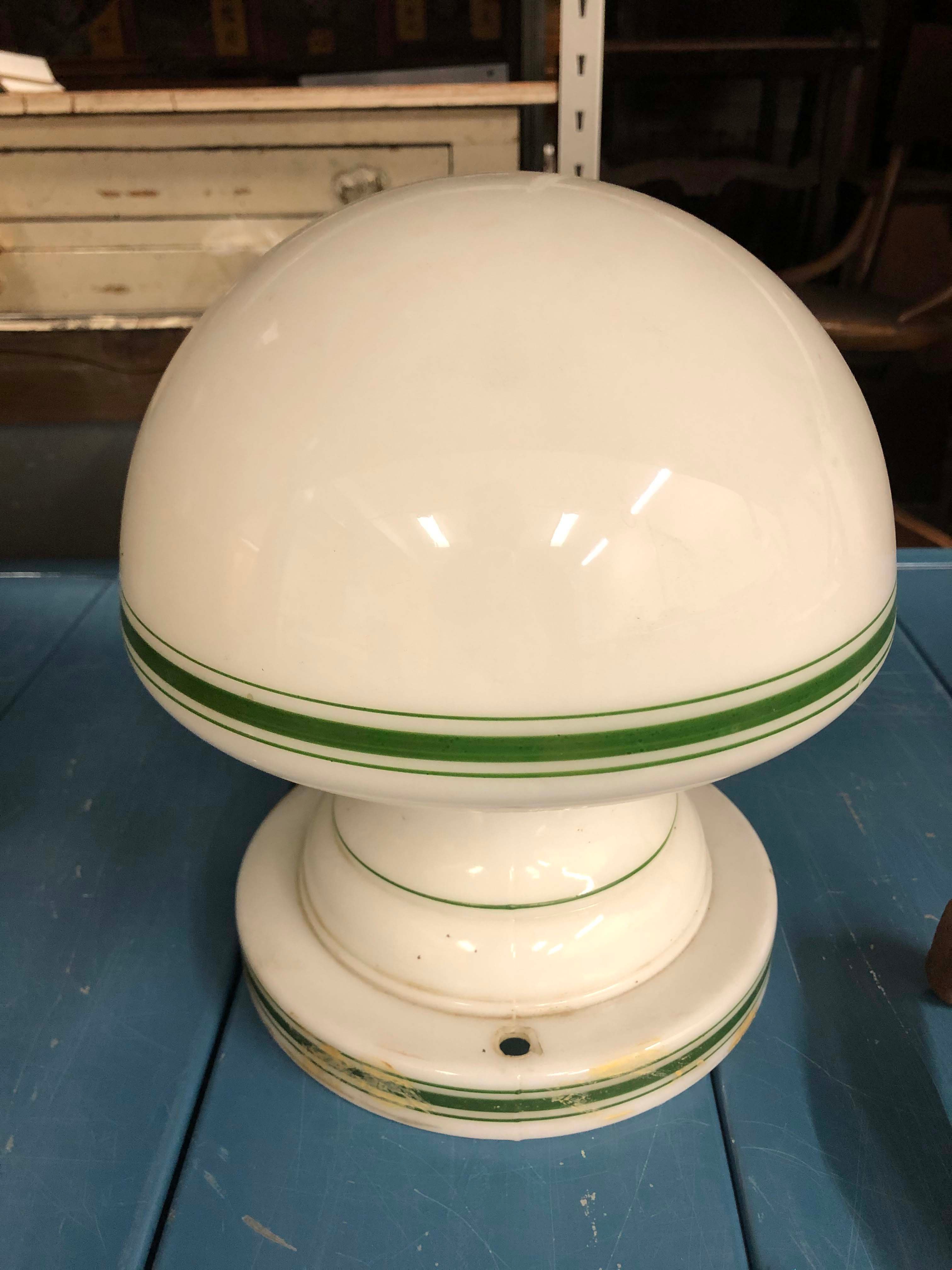
Light Fixture
https://search.heritageburnaby.ca/link/museumartifact90872
- Repository
- Burnaby Village Museum
- Accession Code
- BV020.40.23
- Description
- White glass light fixture with rounded bulb shape. The lamp and the base of the fixture hae a thick green line with two thin lines on either side. There are two holes in the base on opposite sides of each other. There is some tan/beige paint strokes around the base. An additional part is required to actually afix the lamp to the ceiling.
- Object History
- This is an original light fixture for the Eagles House. This house is located on Sperling Avenue and is under the care of the City of Burnaby Planning Department.
- Category
- 02. Furnishings
- Classification
- Lighting Equipment - - Lighting Devices
- Object Term
- Fixture, Lighting
- Colour
- White
- Green
- Historic Neighbourhood
- Burnaby Lake (Historic Neighbourhood)
- Planning Study Area
- Morley-Buckingham Area
Images
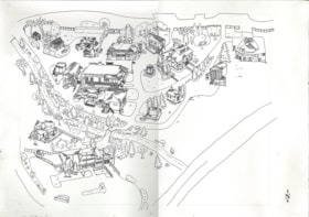
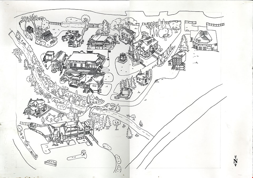
drawing
https://search.heritageburnaby.ca/link/museumartifact91041
- Repository
- Burnaby Village Museum
- Accession Code
- BV020.5.1688
- Description
- Drawing; black ink and pencil on Arches white paper; drawn by Carly Bouwman (unsigned); bird's eye view (site plan) of Burnaby Village Museum site; illustration includes buildings on the site including Adminstration building and parking lot (in foreground); the Love farmhouse; bridge across creek; Tom Irvine house; Village Church; Tram barn; Carousel building; Elworth house; bandstand; Elworth garage; buildings on west side of Hill Street including Japanese Ofuro; Log Cabin; Steam Shed; Blacksmith shop; Old Curly Locomotive; Deer Lake Auto; General Store; Stride Studios; Drug Store and McKay Barbershop and east side of Hill Street including the Real Estate Office; Royal Bank; Music Shop; Burnaby Post; Chinese Herbalist shop; Home Bakery and Ice Cream Parlour; Vancouver Heights Sheet Metal Works; Bell's Dry Goods; Seaforth School; illustration also includes geographic features such as roads; trees; gardens and creek [ca. 2000]
- Object History
- Part of Burnaby Village Museum Administrative Design collection.
- Category
- 08. Communication Artifacts
- Classification
- Documentary Artifacts - - Other Documents
- Object Term
- Drawing
- Colour
- Black
- White
- Measurements
- 39.5 cm x 57 cm
- Maker
- Bouwman, Carly
- Province Made
- British Columbia
- Subjects
- Documentary Artifacts
Images
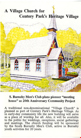
leaflet
https://search.heritageburnaby.ca/link/museumartifact91162
- Repository
- Burnaby Village Museum
- Accession Code
- BV011.44.37
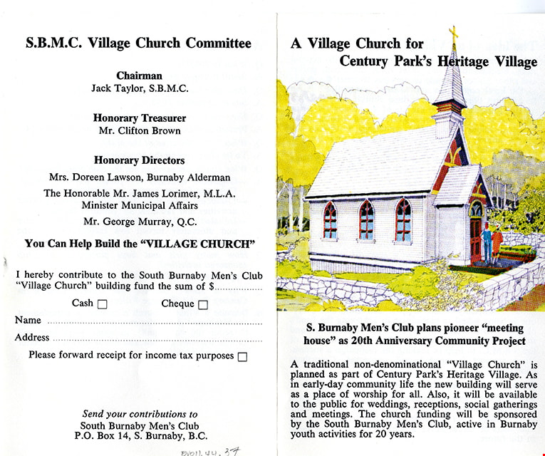
- Description
- Leaflet; bi-fold, colour; illustration of church on front cover with title "A Village Church for / Century Park's Heritage Village / S. Burnaby's Men's Club plans pioneer "meeting / house" as 20th Anniversary Community Project" [1974]. Item is a promotional leaflet of the South Burnaby Men's Club (S.B.M.C) to raise funds to build a "Village Church" in Heritage Village. Back of leaflet provides information on the S.B.M.C. Village Church Committee including names of chairman, treasurer and honorary [sic] directors and a fillable form for donations.
- Object History
- Created by South Burnaby Men's Club and collected as promotional material by Century Park Museum Association who governed Heritage Village Museum. The Village Church opened at Heritage Village in October 1974.
- Category
- 08. Communication Artifacts
- Classification
- Documentary Artifacts - - Other Documents
- Object Term
- Leaflet
- Measurements
- 14.5 x 17.8 cm folded to 14.5 x 9 cm
- Country Made
- Canada
- Province Made
- British Columbia
- Publication Date
- [1974]
- Subjects
- Documentary Artifacts - Leaflets
Images

Dorothy's dream house
https://search.heritageburnaby.ca/link/museumlibrary7354
- Repository
- Burnaby Village Museum
- Collection
- Reference Collection
- Material Type
- Moving Images
- Call Number
- 333.3 BCH VR
- Contributor
- British Columbia Electric Company
- Place of Publication
- [British Columbia, Canada]
- Publisher
- BC Hydro
- Publication Date
- c1954-1955
- Physical Description
- 1 videodisc (30 min.) : sd., col ; 4 3/4 in.
- Library Subject (LOC)
- Construction--British Columbia
- House construction
- Household appliances
- Lions Gate Bridge (Vancouver, B.C.)--History
- Women---British Columbia--Social conditions--1945-
- Kitchens
- British Columbia Electric Company
- British Columbia--History
- Geographic Access
- Vancouver
- Notes
- Summary: Promotional film. The planning, design, construction and features of a BCE "Ease-of-Living" modern home, equipped with up-to-date electrical appliances. Footage of special interest includes a view from a car crossing Lion's Gate Bridge and views of the British Properties.
- Credit note: director: A.J.H. Pullinger; photography: Jack McCallum; photography: Denny Brearley; sound: Dave Pomeroy; sound: Telesound Film Recordings Ltd.; editor: Werner Franz; script: Robert Francis; art direction: Marguerite Roozeboom; sponsored/presented by: British Columbia Electric Company; producing agency/company: Lew Parry Film Productions
Jesse Love farmhouse series
https://search.heritageburnaby.ca/link/museumdescription9782
- Repository
- Burnaby Village Museum
- Date
- [1893-1970] (date of originals), copied 1988-1998, predominant 1988-2000
- Collection/Fonds
- Burnaby Village Museum fonds
- Description Level
- Series
- Physical Description
- approx. 84 cm of textual records + approx. 1,910 photographs + approx. 100 architectural drawings + 3 audio cassettes + 1 videocassette
- Scope and Content
- Series consists of records involved in the purchase, moving, restoration, research, conservation and exhibiting of the Love family farmhouse by Burnaby Village Museum. Records have been arranged into the following subseries: 1) Love farmhouse conservation work files subseries 2) Love farmhouse re…
- Repository
- Burnaby Village Museum
- Collection/Fonds
- Burnaby Village Museum fonds
- Series
- Jesse Love farmhouse series
- Description Level
- Series
- Physical Description
- approx. 84 cm of textual records + approx. 1,910 photographs + approx. 100 architectural drawings + 3 audio cassettes + 1 videocassette
- Scope and Content
- Series consists of records involved in the purchase, moving, restoration, research, conservation and exhibiting of the Love family farmhouse by Burnaby Village Museum. Records have been arranged into the following subseries: 1) Love farmhouse conservation work files subseries 2) Love farmhouse restoration photographs subseries 3) Love farmhouse curatorial files subseries 4) Love farmouse research files subseries 5) Love family photographs 6) Love farmhouse Oral History subseries 7) Love farmhouse architectural drawings subseries
- History
- Jesse Love was born in Swindon, England in 1847 and left England to work on a dairy farm in the Toronto area. While working on the farm in Toronto, he met Martha Leonard who he married in 1879. Martha was born on February 3, 1858 in Bedfordshire, England and had come to Canada with her parents George and Ann Leonard. While living in Toronto, Jesse and Martha had two children, George born March 22, 1880 and Annie Elizabeth on August 24, 1881. About one year after Annie was born, the Love family moved to North Dakota to grow wheat. While living there, they had two more children, Henry who was born August 24, 1883 and Edith Minnie born October 9, 1885. The family decided to move further west after hearing about the fairer weather conditions from Martha’s father, George Leonard, who had settled in Vancouver in 1885. On May 23, 1887, Jesse, Martha and their four children arrived in Vancouver after travelling across Canada from Winnipeg on the first transcontinental train. The Loves made their home in Vancouver while Jesse helped clear land on Granville Street. Their fifth child, Thomas Robert was born on September 17, 1887 and soon after, the family moved to Lulu Island in Richmond where they lived growing vegetables and selling them to Vancouver hotels. While living and farming on Lulu island, the couple had two more girls, Martha (Dot or Dorothy) born on December 17, 1889 and Sarah Marie, born February 8, 1892. On October 6, 1893 an agreement was signed by Jesse Love to purchase 14.52 acres of land from Joseph C. Armstrong. The acreage covered the north east section of District Lot 25 within the newly incorporated District of the Municipality of Burnaby. It was here where the original Love house was built (between October 1893 and April 15, 1894) by Jesse Love with the help of local builder George Salt and father in law, George Leonard. The house consisted of an entrance hall, dining room, lean to kitchen, master bedroom and three bedrooms upstairs. A road was constructed and named Cumberland in 1905 and ran from District Lot 25 through to District Lot 11. The address for the Love home was 1390 Cumberland Road and in the early 1960’s the address was renumbered 7651 Cumberland Street. On the land surrounding the house, Jesse Love planted an orchard along with strawberries and raspberries which he sold at the Fraser Valley Market, T.S. Anandale’s Grocery Store in New Westminster and to hotels around Vancouver. Jesse Love served on the Burnaby School Board and also as a District Councillor in 1901 and from 1904-1907. While living in the house, Jesse and Martha had four more children, Phoebe Leonard, born April 15, 1894, Esther, born August 28, 1896, John Leonard, born June 7, 1899 and Hannah Victoria (also known as Girlie) who was born May 12, 1902. As the family grew to eleven children, additions along with some substantial remodelling in the craftsman style took place. In about 1898, a north wing addition was added to include a parlour with two windows, the construction of two more bedrooms and the relocation of the stair case to the North West wall. In 1903 the front door moved to the north elevation, a front porch was extended along the east wall and a summer lean to kitchen was added to the west elevation. Between 1905 and 1910, a tin embossed ceiling was installed along with an addition of the main kitchen which included a pantry, bathtub and a back porch. In about 1912, five craftsman style windows replaced the original pioneer tent style, the front verandah was enlarged to wrap around the south and east elevations, a back door was installed in the kitchen to access the verandah and wood shingle siding and brackets were added to the exterior. In 1918, at the age of 31 years, Robert Love fell ill due to an influenza epidemic and died on November 23, 1918. Following their son’s death, Martha Love became weak and on August 24, 1920, she passed away. By this time, Jesse had sold off a large percentage of his land and his youngest daughter, Girlie decided to stay on to live and care for him. Since the house was too large for just the two of them, Jesse invited any other children to return and share the residence. For a while his son, George and his wife joined them until 1925, followed by his daughter Sarah Parker (nee Love), her husband William and their three children, Albert, Bill and Elsie. The house remained pretty unchanged until 1928 after Jesse Love died of pneumonia (March 10, 1928) and the house was purchased by Sarah and her husband William Parker who continued to live there with their children. The master bedroom wall on the main floor opened up to the dining room, the kitchen pantry and bathtub converted to an alcove with a marble counter and enlarged window and sink while the bathroom was moved to the upstairs and the furnace and coolers were installed in the crawl space under the kitchen. A hot water tank was installed in the house in 1966. Sarah continued to live in the house until a little while after her husband William died in 1961. She sold the house to her daughter Elsie and husband John Hughes in 1966, who lived in the house along with their son Brent, until August 23, 1971. Mahbir Molchan Papan and his wife Geraldine Papan bought the house August 23, 1971 and by 1982, the house was sold to Nirmal Singh Singha and Narinder Singha. The Papans continued to rent the house from Nirmal Singh Singha and Narinder Singha until the late 1980s. In 1988, the house was scheduled for demolition with the remaining property to be subdivided. Fortunately, a neighbour, Mr. Harvey Elder recognized the farmhouse's historical significance and contacted the Burnaby Historical Society. Following this event, the owners agreed to donate the building to the Burnaby Village Museum (under the Century Park Museum Association) who financed the move of the house from Cumberland Street to the museum site. Heritage planner and architect, Robert Lemon provided guidance for the project. Prior to the move, the two porches were removed and demolished while the kitchen and roof were both separated from the main house. The kitchen and roof of the house were transported to Burnaby Village Museum on May 20, 1988 by Nickel Bros. House Moving company, while the main frame of the house completed its transportation to the museum near the end of May 1988 (due to low overhead wires). The house was moved down Cumberland Street to 10th Avenue, up Canada Way to Sperling and set on temporary footings near Hart House. Robert Lemon oversaw structural improvements such as, upgrading floor joists and creating new foundations to replace the original timber foundation of the farmhouse. The restoration went through several phases of work between 1988 until it opened in November 1998. Restoration began on both the interior and exterior features to be interpreted from the period of 1925. On November 23, 1992, the building was designated a heritage building under Heritage Designation Bylaw 1992, Bylaw Number 9807. In 1993, the architecture firm of Brian G. Hart Associates was appointed for the design and construction supervision of the restoration project. Plans were created for a foundation on the museum site in 1989 and the farmhouse was eventually settled on a permanent foundation behind the Burnaby Village Museum administration building in 1993 along with the reattachment of the roof. The kitchen section was reattached to the main house in 1994 along with skirting around the foundation and the reshingling of the exterior. In 1996, the tin ceiling was removed to make way for the installation of the internal electrical system along with sprinklers, ceiling heating and fire break gyprock. The dining room ceiling joists were consolidated, a pantry and bathroom were added to the kitchen, the downstairs bedroom wall was opened and filled, the dining and kitchen doorways were widened. In 1997, a wheelchair ramp was installed along with a concrete sidewalk, stair rails, cement pads at the base of the stairs and a gravel sink for any excess water. Interior work included painting of the kitchen, restoration and furnishing of the kitchen pantry, insulation of the house floor to protect from rodents along with the reconstruction of the kitchen and house chimneys. The registrar worked together with the curator and conservator and was tasked with a large research project on the house including the family contacts and family history, property information, plans, photographs, artifacts, furnishings, stories etc. all organized in files for easy retrieval. A great deal of research and conservation was undertaken in order to make the interior of the house authentic to the time period as possible. One of the biggest projects was selecting and obtaining wall coverings since much of the original wallpaper was incomplete and poor condition. The conservator and registrar were lucky enough to locate a few samples of the original paper and engage the Bradbury and Bradbury Art Wallpaper Company of Benica, California to reproduce replica designs for free. The City of Burnaby now has its own series “Burnaby Village Papers” produced by this company which are titled “Burnaby Wall”; “Burnaby Border” and “Burnaby Ceiling”. All three of these wallpaper designs have been used in the Love farm house and are also commercially available through the Bradbury and Bradbury Art Wallpaper Company. In 1997, restoration of the kitchen was completed and opened to the public. After the completion of the dining room, main floor bedroom and parlour, the Love farmhouse exhibit opened on November 29, 1998 with an open invitation to the public and extended members of the Love family. Officials including the Mayor, Doug Drummond and Love family members were all present to cut the ribbon for the special event.
- Accession Code
- BV018.41; BV020.5
- Access Restriction
- Restricted access
- Date
- [1893-1970] (date of originals), copied 1988-1998, predominant 1988-2000
- Arrangement
- The majority of the records within series and subseries were arranged by a staff members of Burnaby Village Museum who worked on the historical research and restoration of the house. Other photographs documenting the move and further restoration work were added later and included in the arrangment by format and subject.
- Notes
- Title based on content of series
- Jesse Love farmhouse is described as an Artifact under BV988.33.1
- Some records within this collection have restricted access and are subject to FIPPA
- Accessions BV018.41 and BV020.5 form this fonds
Studies, reports, and conferences series
https://search.heritageburnaby.ca/link/archivedescription186
- Repository
- City of Burnaby Archives
- Date
- 1930-2010
- Collection/Fonds
- Planning Department fonds
- Description Level
- Series
- Scope and Content
- Series consists of the various published and draft reports and studies produced by the Planning Department covering all facets of their operations. During the course of their research and reporting on all planning issues within the City, the Planning Department published or made available studies …
- Repository
- City of Burnaby Archives
- Date
- 1930-2010
- Collection/Fonds
- Planning Department fonds
- Description Level
- Series
- Scope and Content
- Series consists of the various published and draft reports and studies produced by the Planning Department covering all facets of their operations. During the course of their research and reporting on all planning issues within the City, the Planning Department published or made available studies that outlined the findings or proposals that arose from their work and this type of material was all grouped together within this series. These reports and studies ranged from topics such as Burnaby regional studies, transportation and apartment reports, and park and school site needs to Official Community Plans and development schemes related to residential, commercial, and industrial sites. Also found within this series were the records that were created dealing with conferences, workshops, and seminars attended or held by the Burnaby Planning Department staff.
- Media Type
- Textual Record
- Moving Images
Planning Department fonds
https://search.heritageburnaby.ca/link/archivedescription102
- Repository
- City of Burnaby Archives
- Date
- 1940-2016
- Collection/Fonds
- Planning Department fonds
- Description Level
- Fonds
- Physical Description
- 80 m of textual records and other material
- Scope and Content
- Fonds consists of those records created during the regular conduct of business by the Planning Department and its predecessor agencies according to their mandate of providing professional and technical advice to Council on the current and future uses of City land and resources.
- Repository
- City of Burnaby Archives
- Date
- 1940-2016
- Collection/Fonds
- Planning Department fonds
- Physical Description
- 80 m of textual records and other material
- Description Level
- Fonds
- File Class
- 71000 10 (add. 2020)
- 71000 20 (add. 2020)
- 71000 30 (add. 2020)
- 71000 40 (add. 2020)
- Access Restriction
- Subject to FOIPPA
- Reproduction Restriction
- Reproductions subject to FOIPPA.
- Scope and Content
- Fonds consists of those records created during the regular conduct of business by the Planning Department and its predecessor agencies according to their mandate of providing professional and technical advice to Council on the current and future uses of City land and resources.
- History
- The City of Burnaby Planning Department was established on October 9, 1956, when the City Council unanimously carried the motion to create a distinct department to deal with planning issues within the City and appointed Mr. William John Blakely as its head. This decision followed a report and recommendation made by the City’s Chief Administrative Officer which indicated that the role of the Planning Engineer and his staff had quickly expanded to become a separate division within the Engineering Department and that they were functioning as an independent unit in all but name. The proposed separation of the Engineering and Planning departments had been in the works since the early part of 1956 when staff changes and restructuring within the Engineering Department’s Planning Division illustrated the undermanned condition of the Planning Engineer’s office. As a result, Council asked the Chief Administrative Officer to undertake a study examining the feasibility of creating a distinct Planning Department. This report was delivered to Council on July 3, 1956, but was laid over until a Committee of the Council had the opportunity to study the functions of the Planning department to determine the necessity of the proposal. The Committee’s findings were in line with the initial report and the Planning Department was established with a staff of nine (the head Planning Engineer, an Administrative Planner, three Research Planning Assistants, a Draughtsman, a Subdivision Control Clerk, a department Clerk and a Clerk Stenographer). This new department was to offer advice and carry out the work intensive in matters such as zoning and rezoning applications, subdivision control, traffic and transportation planning, and general City planning schemes. Prior to the creation of the Planning Department, a number of bodies within the City had been responsible for fulfilling the functions carried out by this new unit. In the earliest years of the City, the members of Council were responsible for matters of planning and were assisted in their job by the City’s Engineer or any number of hired consultants (e.g. surveyors, cartographers). By 1906, however, the provincial laws surrounding the subdivision process had changed, and local governments were charged with the task of approving all private subdivision plans in their respective Municipalities. In Burnaby, the City Council passed a bylaw decreeing that all subdivision plans were to be submitted to Council for review and the City Engineer was responsible for ensuring compliance with the law. After the first Town Planning Bylaw in 1924 which restricted the type and size of construction that could occur in certain City areas, the Engineering and Building departments were to work together to oversee the enforcement of the Bylaw and the development of City plans. The scope and competence required to carry out this work grew as Burnaby’s population expanded, and in 1930 Council passed the Town Planning Commission Bylaw (No. 1028) that saw the creation of a permanent body – the Town Planning Commission – which was to serve as an advisory body to help direct the planning activities in the City while the actual work continued to be carried out by the Engineering Department. This body was comprised of the Reeve, the Chairman of the School Board, the Chairman of the Park Committee (later, the Board of Parks Commissioners), and six appointed citizens who served three-year terms. Council referred all matters of subdivisions, transportation planning, and rezoning to this Commission, which was later supported in its work by several other special or standing committees such as the Subdivision Committee, the Apartment Committee, the Transportation Committee or the Town Planning Board of Appeal. By 1953, it had become apparent that the advisory committees that were dedicated to these planning issues needed a permanent staff to carry out the work intensive, so a restructuring of the Engineering department resulted in a permanent Planning Engineer’s office being created. The Town Planning Commission continued in its advisory capacity even after the determination came in 1956 to create a separate Planning Department. When Bylaw No. 4473 was passed in 1963, the Town Planning Commission was disbanded in favour of a new Advisory Planning Commission that would turn over all routine matters such as subdivision and rezoning applications to the Planning Department but would offer advice and community input into the more complex planning schemes within the City and act as an intermediary in cases where Council and Planning staff were in disagreement. A new Advisory Planning Commission Bylaw (No. 7600) was adopted in 1980 which allowed for even greater community participation in the planning process. The Planning Department was initially responsible to report directly to Council, but in 1957, the administrative structure of Municipal staff changed with the introduction of the Burnaby Municipal Manager Bylaw (No. 3859) and from that point on, the head of the Planning Department held a direct reporting relationship to the Municipal Manager, who in turn was responsible for reporting the activities of the Department to the City Council. Over the years, the internal structure and the scope of responsibilities of the Department have changed during periods of staff reorganizations. Under the larger umbrella of the Planning and Building Department, Planning has come to be comprised of two divisions: the Current Planning Division and the Long Range Planning Division. The functions of the Current Planning Division include rezoning, subdivision, development plan areas, preliminary plan approvals, urban design, heritage planning, and urban trails and bicycle routes. The Long Range Planning Division is responsible for environmental planning concerns, transportation planning, housing, neighbourhood area planning, social planning and planning information services. In 2022, the Planning and Building Department was reorganized to better align functions with delivery of services. The Climate Action and Engery Division moved from Corporate Services to the Planning and Building Department, while Indigenous Relations and Facilities Management moved to Corporate Services and Lands and Facilities, respectively. The position of Director of Planning and Building was changed to General Manager, Planning and Development. The following individuals have served as Planning Engineer and/or Director of the Planning Department and/or General Manager, Planning and Development for the City of Burnaby: William John Blakely 1954-1956 (as Planning Engineer) 1956-1963 (as Head of the Department) Anthony P. Parr 1964-1993 Don G. Stenson 1993-2001 Jack S. Belhouse 2001-2006 Basil Luksun 2006-2012 Lou Pelletier 2012-2019 Edward Kozak 2019-present
- Formats
- Microforms exist for some records. See series descriptions.
- Media Type
- Textual Record
- Photograph
- Moving Images
- Creator
- City of Burnaby
- Notes
- Title based on contents of fonds
Dinner for Miss Creeden
https://search.heritageburnaby.ca/link/museumlibrary7356
- Repository
- Burnaby Village Museum
- Collection
- Reference Collection
- Material Type
- Moving Images
- Call Number
- 388.46 BCH
- Contributor
- British Columbia Electric Company
- Place of Publication
- [British Columbia, Canada]
- Publisher
- BC Hydro
- Publication Date
- 1947
- Physical Description
- 1 videodisc (36 min.) : sd., col ; 4 3/4 in.
- Library Subject (LOC)
- Natural gas industry
- World War, 1914-1918--Mobilization
- World War, 1939-1945--Mobilization
- Street-railroads
- Electric railroads
- Transportation
- British Columbia--History
- Notes
- Summary: Industrial film. A film about the growth of B.C. Electric from 1906 to 1946, built around the story of stenographer Flossie Creeden, the first female office employee of the company. Footage includes: Goldstream power plant; Vancouver natural gas facilities; BC Electric Railway lines in Fraser Valley; Stave Falls generator plant; Alouette Lake and Ruskin plants; 1939 royal visit; BCE employee's newsletter; A.E. Grauer family at home; office scenes; plans & construction at Bridge River project; BCE employee's service in World Wars I & II; BCE streetcar and trolley bus services
- Credit notes: producer: Lew M. Parry; director: Lew M. Parry; photography: John Young; script: Cecil Maiden; sound: S.G. Wilson; narrator: A.E. Grauer; sponsored/presented by: British Columbia Electric Company; producing agency/company: Trans-Canada Films Ltd.
Operation Mink Farm
https://search.heritageburnaby.ca/link/archivedescription72207
- Repository
- City of Burnaby Archives
- Date
- April 24, 1955
- Collection/Fonds
- Planning Department fonds
- Description Level
- Item
- Physical Description
- 1 film reel ( 6 min., 8 sec.) : col. , si. ; 16 mm
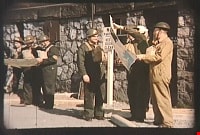
- Scope and Content
- Item consists of a silent motion picture civil defense film entitled, "Operation Mink Farm" produced by the Corporation of the District of Burnaby. The film footage was shot in Burnaby, B.C. on April 24th, 1955. A resolution was passed in February 1955 by the Corporation of the District of Burnaby …
- Repository
- City of Burnaby Archives
- Date
- April 24, 1955
- Collection/Fonds
- Planning Department fonds
- Physical Description
- 1 film reel ( 6 min., 8 sec.) : col. , si. ; 16 mm
- Description Level
- Item
- Record No.
- 566-001
- Access Restriction
- No restrictions
- Reproduction Restriction
- No known restrictions
- Accession Number
- 2009-08
- Scope and Content
- Item consists of a silent motion picture civil defense film entitled, "Operation Mink Farm" produced by the Corporation of the District of Burnaby. The film footage was shot in Burnaby, B.C. on April 24th, 1955. A resolution was passed in February 1955 by the Corporation of the District of Burnaby to create a Civil Defense Board comprised of council members and appointees, whereby the Reeve would act as the chair of the board. Several municipal employees and council members went through Civil Defense training in preparation for an attack or catastrophe. The first portion of the film takes place at the old City Hall (the stone building) with uniformed Air Raid Precaution (A.R.P.) members performing civil defense exercises in the case of a nuclear war and how to care for and rescue injured civilians. Volunteers pose as the injured as they are cared for and transported on stretchers. In the second portion of the film, the local fire department and civil defense members endeavor to get a fire under control with water hoses. The film takes place at a former mink farm in North Burnaby as referred to in the title.
- Media Type
- Moving Images
- Photographer
- Scott, A.F.
- Notes
- Transcribed title
Images

Video
Operation Mink Farm, April 24, 1955
Operation Mink Farm, April 24, 1955
https://search.heritageburnaby.ca/media/hpo/_Data/_Archives_Moving_Images/_Unrestricted/566-001.m4v