Narrow Results By
Subject
- Agriculture 2
- Agriculture - Farms 1
- Buildings 1
- Buildings - Agricultural - Stables 1
- Buildings - Heritage 6
- Buildings - Public - Detention Facilities 1
- Buildings - Religious 1
- Buildings - Religious - Churches 1
- Buildings - Residential 2
- Buildings - Residential - Cottages 1
- Buildings - Residential - Houses 2
- Education 1
Creator
- Alphonse J. Toebaert 1
- Bell, David Charles, 1817-1901 1
- Bernard R. Hill 1
- Bowman and Cullerne 1
- Burchill, Georgine, 1868- 1
- Burnaby (B.C.). Planning Department 1
- Burnaby Community Heritage Commission 1
- Burnaby Planning Department 1
- Burnaby, Robert, 1828-1878 1
- Burnaby Tourism Strategy Advisory Committee 1
- Burnaby Village Museum 1
- Canada. National Parks Branch 1
Person / Organization
- Allen, James Charles 1
- Borstal School 1
- British Columbia Electric Railway 1
- British Columbia Electric Railway Company 1
- British Columbia Mills Timber and Trading Company 1
- Burnaby Fire Department 1
- Burnaby School Board 1
- Burnaby Village Museum 3
- Canadian Institute of Mining and Metallurgy 1
- Ceperley, Grace 3
- Ceperley, H.T. 3
- Clarke, Ellen 1
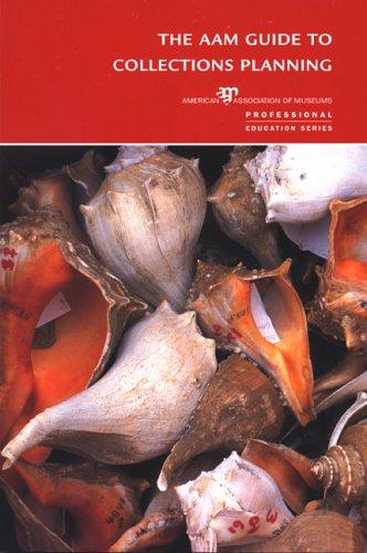
The AAM guide to collections planning
https://search.heritageburnaby.ca/link/museumlibrary6968
- Repository
- Burnaby Village Museum
- Collection
- Reference Collection
- Material Type
- Book
- ISBN
- 0931201888
- Call Number
- 069.5 GAR
- Place of Publication
- Washington, D.C.
- Publisher
- American Association of Museums
- Publication Date
- c2004
- Physical Description
- viii, 93 p. ; 23 cm.
- Library Subject (LOC)
- Museums--Collection management--United States
- Museums--United States--Planning
- Museums--United States--Management
- Notes
- Includes bibliographical references (p. 73-76) and index.
A development programme for Burnaby Lake Regional Park
https://search.heritageburnaby.ca/link/museumlibrary5165
- Repository
- Burnaby Village Museum
- Author
- Burnaby Planning Department
- Publication Date
- 1975
- Call Number
- 333.78 BUR copy 1
- Repository
- Burnaby Village Museum
- Collection
- Reference Collection
- Material Type
- Book
- Call Number
- 333.78 BUR copy 1
- Author
- Burnaby Planning Department
- Place of Publication
- Burnaby, B.C.
- Publisher
- Planning Dept.
- Publication Date
- 1975
- Physical Description
- 63, xi p. : ill. ; 22 x 35 cm
- Library Subject (LOC)
- Parks--British Columbia--Burnaby
- City planning--British Columbia--Burnaby
- Burnaby Lake Regional Park (B.C.)
- Subjects
- Planning - City Planning
- Notes
- Includes bibliographical references.
- 2 copies held ; copy 1
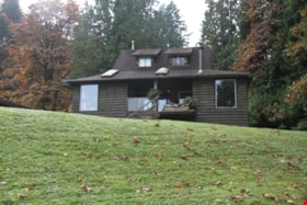
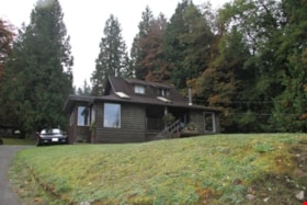
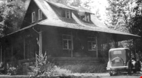
Alfred & Ruth MacLeod Cottage
https://search.heritageburnaby.ca/link/landmark503
- Repository
- Burnaby Heritage Planning
- Description
- Located atop a hill on the southern shore of picturesque Deer Lake, the Alfred and Ruth MacLeod Cottage is a one and one-half storey, wood-frame, rustic Arts and Crafts-style bungalow. The cottage is well-maintained, but has been altered through the enclosure of much of its original wraparound vera…
- Associated Dates
- 1913
- Repository
- Burnaby Heritage Planning
- Geographic Access
- Deer Lake Drive
- Associated Dates
- 1913
- Description
- Located atop a hill on the southern shore of picturesque Deer Lake, the Alfred and Ruth MacLeod Cottage is a one and one-half storey, wood-frame, rustic Arts and Crafts-style bungalow. The cottage is well-maintained, but has been altered through the enclosure of much of its original wraparound verandah. Its sits on the brow of a steep slope, with panoramic views north to Deer Lake.
- Heritage Value
- The Alfred and Ruth MacLeod Cottage is valued as a significant example of the early development of summer estates in Burnaby, specifically in the Deer Lake neighbourhood, that attracted residents from the burgeoning cities of New Westminster and Vancouver. Access to the area was facilitated by the construction of the Burnaby Lake Interurban tramline, which opened in June 1911. This modest, rustic cottage illustrates the desire for a simple country lifestyle and retreat into nature of those who settled on the south shore of Deer Lake. While the grand mansions on the north shore of Deer Lake are set in formally landscaped gardens, the informality of this cottage demonstrates reverence for its natural, wooded surroundings, oriented towards views of Deer Lake. The Alfred and Ruth MacLeod Cottage is important for its connection with prominent New Westminster insurance and real estate broker, Alfred W. MacLeod, and his wife, Ruth. The MacLeods had recently constructed a large city home, and built this cottage as a summer residence in 1913. In 2005, the Alfred and Ruth MacLeod Cottage was purchased by the City of Burnaby and today constitutes part of the Deer Lake Park Heritage Precinct, which is Burnaby's most significant collection of historic sites.
- Defining Elements
- Key elements that define the heritage character of the Alfred and Ruth MacLeod Cottage include its: - secluded setting on the brow of a steep hill on the southern shore of Deer Lake, with expansive views of Deer Lake to the north - residential form, scale and massing as expressed by its one and one-half storey rectangular plan, side-gabled roof, hipped roof over original verandah and two shed dormers - associated landscape features such as mature coniferous and deciduous trees surrounding the property
- Historic Neighbourhood
- Burnaby Lake (Historic Neighbourhood)
- Planning Study Area
- Morley-Buckingham Area
- Function
- Primary Historic--Single Dwelling
- Primary Current--Single Dwelling
- Cadastral Identifier
- P.I.D.000-708-038
- Boundaries
- The Alfred and Ruth MacLeod Cottage is comprised of a single residential lot located at 6466 Deer Lake Drive, Burnaby.
- Area
- 13354.63
- Contributing Resource
- Building
- Ownership
- Public (local)
- Documentation
- City of Burnaby Planning and Building Department, Heritage Site Files
- Street Address
- 6466 Deer Lake Drive
Images
Andy Johnson House
https://search.heritageburnaby.ca/link/landmark515
- Repository
- Burnaby Heritage Planning
- Description
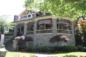
- The Andy Johnson House is a large, one and one-half storey plus above-ground basement wood-frame mansion on a rubble-stone granite foundation with a red terra cotta pantile roof and an octagonal corner turret. The building stands in a prominent location on a corner lot on Kingsway, one of Burnaby’s…
- Associated Dates
- 1912
- Formal Recognition
- Community Heritage Register
- Other Names
- Andrew M. & Margaret Johnson House 'Glenedward'
- Street View URL
- Google Maps Street View
- Repository
- Burnaby Heritage Planning
- Other Names
- Andrew M. & Margaret Johnson House 'Glenedward'
- Geographic Access
- Kingsway
- Associated Dates
- 1912
- Formal Recognition
- Community Heritage Register
- Enactment Type
- Council Resolution
- Enactment Date
- 26/05/2003
- Description
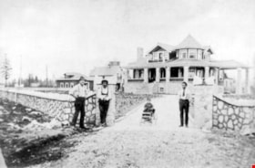
- The Andy Johnson House is a large, one and one-half storey plus above-ground basement wood-frame mansion on a rubble-stone granite foundation with a red terra cotta pantile roof and an octagonal corner turret. The building stands in a prominent location on a corner lot on Kingsway, one of Burnaby’s main transportation and commercial corridors, and stands adjacent to the Burlington Square Development.
- Heritage Value
- The Andy Johnson House 'Glenedward' is a valued representation of a prominent upper middle-class family dwelling from the pre-First World War era. Andrew M. Johnson (1861-1934), an early Vancouver pioneer, and his wife Margaret built this house in 1912, in an imposing style favoured by the newly wealthy of the prewar boom period. Born in Norway, Andrew Johnson arrived in Vancouver just months after the Great Fire of 1886 and went into partnership with J. (Ollie) Atkins in a transportation company that became the Mainland Transfer Company, eventually the largest of its kind in Vancouver. Johnson also operated Burnaby's historic Royal Oak Hotel, once located on the opposite corner from his estate. Additionally, the Andy Johnson House is significant for the high-quality design and construction of both the house and its landscaped setting. Designed in the British Arts and Crafts style, the house exhibits a rare degree of opulence in building materials, including imported terra cotta roof tiles, oak and walnut interior millwork, and stained glass manufactured by the Royal City Glass Company. The rubble-stone foundations and perimeter walls were obtained from two massive granite glacial erratic boulders found on the property. The house has been relocated closer to the corner, but the encircling stone walls, the gate posts and gates manufactured by the Westminster Iron Works and some of the original plantings have been retained. A grouping of three giant Sequoias, other mature deciduous trees and massings of shrubbery indicate the type of landscape setting considered appropriate for an estate house in the early years of the twentieth century.
- Defining Elements
- Key elements that define the heritage character of the Andy Johnson House include its: - corner location on Kingsway at Royal Oak Avenue - residential form, scale and massing as expressed by the one and one-half storey height, above-ground basement, octagonal corner turret and rectangular plan - British Arts and Crafts details such as the use of natural indigenous materials, half-timbering in the gables and dormers, picturesque roofline, cedar shingle siding, extended eaves, native granite rubble-stone foundation with red-coloured mortar, and granite piers and chimneys - additional exterior features such as the central front entrance, elaborate wrap-around verandah, porte-cochere and balcony at second storey lighted with original cast iron electric lanterns - red terra cotta pantile roof cladding - fenestration, such as double-hung 1-over-1 wooden-sash windows with stained glass and leaded lights in the upper sash - original interior features such as fireplaces, wainscoting finished with oak and walnut millwork, and three-quarter sawn oak flooring - associated landscape features including three giant Sequoias. granite walls, granite gate posts and wrought iron gates
- Historic Neighbourhood
- Central Park (Historic Neighbourhood)
- Planning Study Area
- Marlborough Area
- Builder
- J.C. Allen
- Function
- Primary Historic--Single Dwelling
- Primary Current--Eating or Drinking Establishment
- Community
- Burnaby
- Cadastral Identifier
- 003-004-538
- Boundaries
- The Andy Johnson House is comprised of a single residential lot located at 5152 Kingsway, Burnaby
- Area
- 1424.21
- Contributing Resource
- Building
- Ownership
- Private
- Street Address
- 5152 Kingsway
- Street View URL
- Google Maps Street View
Images
Angus & Margaret MacDonald House
https://search.heritageburnaby.ca/link/landmark495
- Repository
- Burnaby Heritage Planning
- Description
- Set on a large corner lot at North Esmond Avenue and Oxford Street, the Angus & Margaret MacDonald House is a prominent, two and one-half storey Queen Anne Revival-style residence. The high hipped roof has open projecting gables. The house is a landmark within the Vancouver Heights neighbourhood of…
- Associated Dates
- 1909
- Formal Recognition
- Heritage Designation, Community Heritage Register
- Street View URL
- Google Maps Street View
- Repository
- Burnaby Heritage Planning
- Geographic Access
- Oxford Street
- Associated Dates
- 1909
- Formal Recognition
- Heritage Designation, Community Heritage Register
- Enactment Type
- Bylaw No. 12174
- Enactment Date
- 11/12/2006
- Description
- Set on a large corner lot at North Esmond Avenue and Oxford Street, the Angus & Margaret MacDonald House is a prominent, two and one-half storey Queen Anne Revival-style residence. The high hipped roof has open projecting gables. The house is a landmark within the Vancouver Heights neighbourhood of North Burnaby, on a high point of land overlooking Burrard Inlet and the North Shore Mountains.
- Heritage Value
- The MacDonald House is valued as one of Burnaby’s most elaborate examples of the Queen Anne Revival style. The house retains many of its original features, including a prominent front corner turret wrapped by a clamshell verandah. The eclectic and transitional nature of Edwardian-era architecture is demonstrated by the late persistence of these Queen Anne Revival details, combined with the use of newly-popular classical revival elements such as Ionic columns. The interior retains a number of original architectural elements, and the early garage at the rear originally housed Angus MacDonald’s Cadillac, one of the first known automobiles owned by a Burnaby resident. Constructed in 1909, this house was built for Angus MacDonald (1857-1943) and his wife, Margaret Isabella Thompson MacDonald (1862-1939). Angus MacDonald, an electrical contractor, relocated from Nova Scotia to Vancouver in 1891 and served on Vancouver Council from 1904-08. The MacDonald family moved to Burnaby upon his retirement from the B.C. Electric Railway Company, and he then served the North Burnaby Ward as a councillor from 1911-1916 and again in 1921. MacDonald Street in Burnaby was named in his honour. The MacDonald House has additional significance as one of the surviving landmark residences, built between 1909 and 1914, during the first development of Vancouver Heights. In 1909, C.J. Peter and his employer, G.F. and J. Galt Limited, initiated the development of this North Burnaby neighbourhood, promoting it as one of the most picturesque districts in the region and an alternative to the CPR’s prestigious Shaughnessy Heights development in Vancouver. Buyers were obligated to build houses worth $3,500 at a time when the average house price was $1,000. Reputed to be the second house built in the subdivision, this house cost $7,000 to build.
- Defining Elements
- Key elements that define the heritage character of the MacDonald House include its: - prominent corner location in the Vancouver Heights neighbourhood, with views to Burrard Inlet and the North Shore Mountains - residential form, scale and massing as exemplified by its two and one-half storey height, full basement, compound plan, and high hipped roof with gabled projections at the front and side - wood-frame construction including wooden lapped siding, trim and mouldings - rubble-stone granite foundation - Queen Anne Revival details such as scroll-cut modillions, octagonal corner turret, wraparound, clamshell verandah with classical columns, and projecting square and semi-octagonal bays - external red-brick chimney with corbelled top - original windows including double-hung, 1-over-1 wooden sash windows in single and double assembly, and arched-top casement windows in the gable peaks - original interior features such as the main staircase, a panelled dining room with a fireplace and built-in cabinets, a living room with a parquet floor, and a rear den with an oak mantle and tiled hearth - associated early wood-frame garage at the rear of the property - landscape features such as mature coniferous and deciduous trees surrounding the property
- Historic Neighbourhood
- Vancouver Heights (Historic Neighbourhood)
- Planning Study Area
- Burnaby Heights Area
- Organization
- British Columbia Mills Timber and Trading Company
- Function
- Primary Historic--Single Dwelling
- Primary Current--Single Dwelling
- Community
- Vancouver Heights
- Cadastral Identifier
- P.I.D.011-999-462
- Boundaries
- The MacDonald House is comprised of a single residential lot located at 3814 Oxford Street, Burnaby.
- Area
- 566.71
- Contributing Resource
- Building
- Ownership
- Private
- Documentation
- City of Burnaby Planning and Building Department, Heritage Site Files
- Street Address
- 3814 Oxford Street
- Street View URL
- Google Maps Street View
Images
Big Bend Neighbourhood
https://search.heritageburnaby.ca/link/landmark840
- Repository
- Burnaby Heritage Planning
- Associated Dates
- 1955-2008
- Heritage Value
- The Big Bend Neighbourhood in Burnaby maintained its status as an important agricultural area in the City in the years following 1955 and it also solidified its role as a prime industrial and commercial district. In 1972, the Big Bend Development Plan was adopted by Council and soon thereafter, approximately 620 acres of land were incorporated into the Agricultural Land Reserve. These lands have been set aside for agricultural and limited recreation purposes. By the 2000s, 160 acres of land were considered highly productive agricultural areas, and over 400 acres of land had been secured as parkland, including the Fraser Foreshore Park. The area also developed large commercial and industrial districts including those at Marine Way/Boundary, the Glenlyon Estates, Riverfront Business Park, Burnaby Business Park, and Glenwood Industrial Estates.
- Historic Neighbourhood
- Fraser Arm (Historic Neighbourhood)
- Planning Study Area
- Big Bend Area
Images
Bill Copeland Sports Centre & Burnaby Lake Arena
https://search.heritageburnaby.ca/link/landmark819
- Repository
- Burnaby Heritage Planning
- Geographic Access
- Kensington Avenue
- Associated Dates
- 1965
- Heritage Value
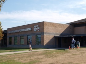
- In February 1965, the Planning Department presented to Burnaby Council a preliminary Development Plan entitled "Pacific Sports Centre," for the area immediately west of Burnaby Lake. This report proposed a conceptual plan for a comprehensive range of indoor and outdoor sporting facilities adjacent to Burnaby Lake. The idea was accepted by Council and led to the construction of the Burnaby Lake Rink beside the C.G. Brown Pool. In 1973, Burnaby and New Westminster jointly hosted the Canada Summer Games for which a rowing course and pavilion were built at Burnaby Lake and the success of the games and the sports facilities added within Burnaby Lake Park provided further stimulus for the creation of the sports and recreation facilities at this site.
- Historic Neighbourhood
- Burnaby Lake (Historic Neighbourhood)
- Planning Study Area
- Ardingley-Sprott Area
- Street Address
- 3676 Kensington Avenue
- Street View URL
- Google Maps Street View
Images
Boy craft : containing plans and working drawings with clear and concise descriptions of useful articles, toys, and games : for boys of 10 to 16 years to construct.
https://search.heritageburnaby.ca/link/museumlibrary1035
- Repository
- Burnaby Village Museum
- Collection
- Reference Collection
- Material Type
- Book
- Call Number
- 745.59 BOY
- Place of Publication
- Racine, Wis.
- Publisher
- Whitman Publishing Company
- Publication Date
- c1928
- Physical Description
- 208 p. : ill. ; 20 cm.
- Library Subject (LOC)
- Handicraft
- Toys
- Notes
- "The material in this book... collected almost entirely from the pages of 'The junior home magazine', the well known children's publication." -- title page.
Brentwood Neighbourhood
https://search.heritageburnaby.ca/link/landmark669
- Repository
- Burnaby Heritage Planning
- Associated Dates
- 1925-1954
- Heritage Value
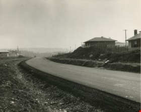
- In July, 1953, Burnaby's Municipal Council gave approval for the construction of a $12,000,000 residential and shopping development to be called Brentwood Park, located on the northeast corner of Lougheed and Willingdon. Plans called for about 400 homes and a 30-acre shopping centre to be built in this new subdivision - the first large residential subdivision in Burnaby to be developed with sewers and paved streets as well as other services.
- Planning Study Area
- Brentwood Area
Images
Buena Vista Neighbourhood
https://search.heritageburnaby.ca/link/landmark759
- Repository
- Burnaby Heritage Planning
- Associated Dates
- 1905-1924
- Heritage Value
- The Buena Vista neighbourhood (so named for its wonderful views) grew out of its proximity to Edmonds and New Westminster and was developed in the period 1911-1912. By the 1950s, the area had been further subdivided and in 1986, Burnaby Municipal Council adopted the Cariboo Hills Development Plan for the neighbourhood to maintain its character as a residential area of the city.
- Historic Neighbourhood
- East Burnaby (Historic Neighbourhood)
- Planning Study Area
- Cariboo-Armstrong Area
Images
Burnaby centennial anthology : stories of early Burnaby
https://search.heritageburnaby.ca/link/museumlibrary5472
- Repository
- Burnaby Village Museum
- Edition
- Rev. ed.
- Publication Date
- 1994
- Call Number
- 971.133 BUR COPY 3
stages of our planning.
Jim Wolf, Burnaby Planning Department and Historian - who made the
photographic copies, and provided much technical assistance.
City of Burnaby Print Shop Supervisor Nick Karanasos, and printer Robert
Lamoureux.
Lorna Estridge - City Clerk’s Department for her frequent assistance
- Repository
- Burnaby Village Museum
- Collection
- Digital Reference Collection
- Material Type
- Book
- ISBN
- 0969282826
- Call Number
- 971.133 BUR COPY 3
- Edition
- Rev. ed.
- Place of Publication
- Burnaby, B.C.
- Publisher
- City of Burnaby
- Publication Date
- 1994
- Physical Description
- 531 p. : ill. ; 28 cm.
- Library Subject (LOC)
- Burnaby (B.C.)--History
- Burnaby (B.C.)
- Biography
- Notes
- Includes index.
- 3 copies held: copy 3.
Digital Books
Burnaby Lake Neighbourhood
https://search.heritageburnaby.ca/link/landmark821
- Repository
- Burnaby Heritage Planning
- Associated Dates
- 1955-2008
- Heritage Value
- In 1966 Burnaby Lake was identified as a key potential regional park in the GVRD ’s Regional Park Plan for the Lower Mainland. The lake was to be developed for nature study, strolling, trail riding, canoeing, sightseeing and picnicking. It was formally recognized as a regional nature park in 1979, at which time the GVRD assumed management of the park through a lease agreement with the City of Burnaby. In 1993 Burnaby Lake was selected by the City of Burnaby to be included in Greater Vancouver ’s Green Zone, and was identified as a key component of the GVRD ’s Park and Outdoor Recreation System (PORS) for the Burrard/Peninsula/Richmond sector, which includes Burnaby, Vancouver, New Westminster, and Richmond.
- Historic Neighbourhood
- Burnaby Lake (Historic Neighbourhood)
- Planning Study Area
- Burnaby Lake Area
Images
Burnaby Metrotown : a development plan
https://search.heritageburnaby.ca/link/museumlibrary4951
- Repository
- Burnaby Village Museum
- Collection
- Special Collection
- Material Type
- Book
- Accession Code
- BV006.24.38
- Call Number
- 307.1 BUR
- Place of Publication
- [Burnaby, B.C.]
- Publisher
- Burnaby Planning Dept.
- Publication Date
- 1977
- Printer
- College Printers Ltd.
- Physical Description
- 83 p. : ill. : 22 x 28 cm.
- Inscription
- "Page 67 Land purchase" [Handwritten in blue ink on page 3]
- Library Subject (LOC)
- City planning--British Columbia
- City planning--British Columbia--Burnaby
- Central business districts--British Columbia--Vancouver Region
- Vancouver (B.C.)--Suburbs and environs
- Burnaby, B.C.
- Metrotown (Burnaby, B.C.)
- Community development, Urban
- Central business districts
- Subjects
- Planning - City Planning
Burnaby's heritage : an inventory of buildings and structures
https://search.heritageburnaby.ca/link/museumlibrary5437
- Repository
- Burnaby Village Museum
- Author
- Luxton, Donald, 1954-
- Wolf, Jim
- Edition
- Rev.
- Publication Date
- 2011
- c2007
- Call Number
- 971.133 LUX COPY 1
Financial assistance for this project was provided by the Government of British Columbia
through the Community Heritage Planning Program
Matching funding was provided by the City of Burnaby
© 2007 City of Burnaby (revised 2011)
Front Cover: Saint John the Divine Church, 1905 [BCA]
Title Page: Looking north
- Repository
- Burnaby Village Museum
- Collection
- Digital Reference Collection
- Material Type
- Book
- ISBN
- 0969282893
- Call Number
- 971.133 LUX COPY 1
- Edition
- Rev.
- Author
- Luxton, Donald, 1954-
- Wolf, Jim
- Place of Publication
- Burnaby, B.C.
- Publisher
- City of Burnaby
- Publication Date
- 2011
- c2007
- Physical Description
- 157 p. : ill. ; 28 cm.
- Library Subject (LOC)
- Architecture
- Historic buildings
- Buildings
- Historic sites
- Subjects
- Buildings
- Buildings - Heritage
- Notes
- Includes bibliographical references and index.
- 2 copies held: copy 1.
Digital Books
Burnaby tourism strategy
https://search.heritageburnaby.ca/link/museumlibrary7603
- Repository
- Burnaby Village Museum
- Collection
- Reference Collection
- Material Type
- Book
- Call Number
- 338.4791 BUR
- Place of Publication
- Burnaby, BC
- Publisher
- City of Burnaby
- Publication Date
- 1994
- Physical Description
- 82 p. : ill. ; 29 cm.
- Library Subject (LOC)
- City planning--British Columbia--Burnaby
- Subjects
- Planning - City Planning
- Notes
- "Produced by the Burnaby Tourism Strategy Advisory Committee Membership outlined in Appendix C, Project manager, Phil Sanderson, Economic Development Office Economic Development Office, City of Burnaby. Consultants: James MacGregor (Lavalin Corp.) in collaboration with Addison Travel Marketing, G.S. Sue Henderson & Associates."
Burnaby trail study
https://search.heritageburnaby.ca/link/museumlibrary5479
- Repository
- Burnaby Village Museum
- Collection
- Reference Collection
- Material Type
- Book
- Call Number
- 711.558 BUR
- Place of Publication
- Burnaby
- Publisher
- Planning Dept.
- Publication Date
- 1980
- Physical Description
- 105 p. : ill. ; 36 cm.
- Library Subject (LOC)
- City planning--British Columbia
- Trails--British Columbia--Burnaby
- City planning--British Columbia--Burnaby
- Parks--British Columbia--Burnaby
- Subjects
- Planning - City Planning
- Notes
- Document inserted in cover: "Re: access, trail development Burnaby foreshore areas, acting municipal manager's recommendation", July 06, 1988, Item 29, Manager's report no. 47, council meeting: 1988/07/11.
- Oversized book.
The Business man's library, volume 7 : book on advertising ; how to advertise a product - the principles of practical publicity for manufacturer and merchant - the tools and methods, mediums and means of the advertiser - how to plan an advertising campaign - how to write copy - how to select mediums - how to keep track of returns - how to judge results
https://search.heritageburnaby.ca/link/museumlibrary601
- Repository
- Burnaby Village Museum
- Collection
- Special Collection
- Material Type
- Book
- Accession Code
- BV985.205.7
- Call Number
- 658 SYS v.7
- Place of Publication
- Chicago
- Publisher
- The System Company
- Publication Date
- 1909
- c1908
- Physical Description
- v, 165 p. : ill. ; 22 cm.
- Inscription
- "Dorothy Higgins" [handwritten in pencil on front endpapers]
- Library Subject (LOC)
- Business
- Notes
- Volume 7 of 10
Buying wood & building farms : marketing lumber and farm building designs on the Canadian Prairies, 1880 to 1920
https://search.heritageburnaby.ca/link/museumlibrary774
- Repository
- Burnaby Village Museum
- Collection
- Reference Collection
- Material Type
- Book
- ISBN
- 0660138018
- Call Number
- 381.45 MIL
- Author
- Mills, G. E.
- Place of Publication
- Ottawa
- Publisher
- National Historic Sites, Parks Service, Environment Canada
- Publication Date
- c1991
- Physical Description
- 199 p. : ill., plans ; 22 x 28 cm.
- Inscription
- "Burnaby Village Museum", handwritten in ink on cover page.
- Library Subject (LOC)
- Lumber trade--Prairie Provinces
- Farm buildings--Prairie Provinces--Design
- Notes
- Issued also in French under title: Acheter son bois et construire sa ferme.
- Includes bibliographical references: p. 191-199.
Bygones of Burnaby : an anecdotal history
https://search.heritageburnaby.ca/link/museumlibrary5462
- Repository
- Burnaby Village Museum
- Author
- McGeachie, Pixie, 1921-
- Publication Date
- 1976
- c1975
- Call Number
- 971.133 MCG COPY 4
- Repository
- Burnaby Village Museum
- Collection
- Digital Reference Collection
- Material Type
- Book
- Call Number
- 971.133 MCG COPY 4
- Author
- McGeachie, Pixie, 1921-
- Place of Publication
- Burnaby, B.C.
- Publisher
- Century Park Museum Association
- Publication Date
- 1976
- c1975
- Physical Description
- 108 p. : ill. ; 23 cm.
- Library Subject (LOC)
- Burnaby (B.C.)--History
- Notes
- 4 copies held: copy 4.
Digital Books
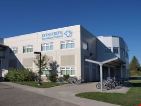
Byrne Creek Secondary School
https://search.heritageburnaby.ca/link/landmark849
- Repository
- Burnaby Heritage Planning
- Geographic Access
- 18th Street
- Associated Dates
- 2005
- Heritage Value
- Byrne Creek School opened in 2005 and accommodates students from grades 8 through 12. When built, the school was created to house as many as 1200 students, but by 2009, plans have been prepared to increase that capacity to 1500.
- Historic Neighbourhood
- Edmonds (Historic Neighbourhood)
- Planning Study Area
- Stride Avenue Area
- Street Address
- 7777 18th Street
- Street View URL
- Google Maps Street View
