Narrow Results By
Subject
- Building Components 2
- Buildings - Heritage 1
- Buildings - Residential - Houses 1
- Buildings - Schools - Universities and Colleges 1
- Ceremonies - Awards 1
- Construction Tools and Equipment 1
- Documentary Artifacts - Architectural Drawings 2
- Documentary Artifacts - Maps 1
- Education 2
- Geographic Features - Parks 5
- Government 1
- Government - Local Government 2

Bill Copeland Sports Centre & Burnaby Lake Arena
https://search.heritageburnaby.ca/link/landmark819
- Repository
- Burnaby Heritage Planning
- Geographic Access
- Kensington Avenue
- Associated Dates
- 1965
- Heritage Value
- In February 1965, the Planning Department presented to Burnaby Council a preliminary Development Plan entitled "Pacific Sports Centre," for the area immediately west of Burnaby Lake. This report proposed a conceptual plan for a comprehensive range of indoor and outdoor sporting facilities adjacent to Burnaby Lake. The idea was accepted by Council and led to the construction of the Burnaby Lake Rink beside the C.G. Brown Pool. In 1973, Burnaby and New Westminster jointly hosted the Canada Summer Games for which a rowing course and pavilion were built at Burnaby Lake and the success of the games and the sports facilities added within Burnaby Lake Park provided further stimulus for the creation of the sports and recreation facilities at this site.
- Historic Neighbourhood
- Burnaby Lake (Historic Neighbourhood)
- Planning Study Area
- Ardingley-Sprott Area
- Street Address
- 3676 Kensington Avenue
- Street View URL
- Google Maps Street View
Images


Inkwells to Internet: A History of Burnaby Schools
https://search.heritageburnaby.ca/link/museumlibrary7551
- Repository
- Burnaby Village Museum
- Publication Date
- 2020
- Call Number
- 371 CAR
- Repository
- Burnaby Village Museum
- Collection
- Reference Collection
- Digital Reference Collection
- Material Type
- Book
- ISBN
- 978-0-9781979-2-6
- Call Number
- 371 CAR
- Place of Publication
- Burnaby
- Publisher
- City of Burnaby
- Publication Date
- 2020
- Physical Description
- vii, 35 p. : ill. ; 29 cm.
- Library Subject (LOC)
- Burnaby (B.C.)--History
- Schools--British Columbia--Burnaby
- Subjects
- Education
- Notes
- "Includes index"
- A history of the Burnaby school district and individual school buildings in Burnaby, BC, between 1893 and 2013.
- The “First Nations cemetery” described on page 109 in Mary Johnson’s recollections was originally written as “Indian” and may refer to the Khalsa Diwan Society’s Sikh cremations at the Vancouver Cemetery.
Images

Digital Books
![Margaret Manifold and the Community Asset Mapping System, [2005] thumbnail](/media/hpo/_Data/_Archives_Images/_Unrestricted/535/535-1927-1.jpg?width=280)
Margaret Manifold and the Community Asset Mapping System
https://search.heritageburnaby.ca/link/archivedescription96243
- Repository
- City of Burnaby Archives
- Date
- [2005]
- Collection/Fonds
- Burnaby NewsLeader photograph collection
- Description Level
- File
- Physical Description
- 2 photographs (tiff) : col.
- Scope and Content
- File contains photographs of Margaret Manifold, of the City of Burnaby Planning Department, posing with print-outs of maps that will form the online Community Asset Mapping System. A large aerial photograph of Burnaby and the Lower Mainland is on the wall behind Manifold.
- Repository
- City of Burnaby Archives
- Date
- [2005]
- Collection/Fonds
- Burnaby NewsLeader photograph collection
- Physical Description
- 2 photographs (tiff) : col.
- Description Level
- File
- Record No.
- 535-1927
- Access Restriction
- No restrictions
- Reproduction Restriction
- No restrictions
- Accession Number
- 2018-12
- Scope and Content
- File contains photographs of Margaret Manifold, of the City of Burnaby Planning Department, posing with print-outs of maps that will form the online Community Asset Mapping System. A large aerial photograph of Burnaby and the Lower Mainland is on the wall behind Manifold.
- Media Type
- Photograph
- Photographer
- Medig, Kari
- Notes
- Title based on caption
- Collected by editorial for use in a February 2005 issue of the Burnaby NewsLeader
- Caption from metadata: "Margaret Manifold of the City of Burnaby's planning department poses with some hard copies of the online Community Assett Mapping System, which will soon be on the city's website."
Images
![Margaret Manifold and the Community Asset Mapping System, [2005] thumbnail](/media/hpo/_Data/_Archives_Images/_Unrestricted/535/535-1927-1.jpg)

Ink
https://search.heritageburnaby.ca/link/museumartifact90812
- Repository
- Burnaby Village Museum
- Accession Code
- BV020.40.3
- Description
- Glass bottle of black ink, with a plastic textured lid. The front label is yellow with a gold border, and a blue band along the bottom of the label. It has a black ink stain down the front. The back label is smaller and lighter colour with a yellow stain that reaches to the middle of the label.
- Object History
- This ink came along with a lettering guide used in the City of Burnaby's Planning Department, in the late 1950s. See also BV020.40.2
- Classification
- Written Communication T&E - - Writing Accessories
- Object Term
- Ink
- Marks/Labels
- Chin-Chin waterproof Liquid PearlInk / Sole Canadian Distributors / Made in Germany / Protect from Freezing
- Colour
- Black
- Yellow
- Blue
- Measurements
- 30cm high
- Maker
- PearlInk
- Subjects
- Documentary Artifacts - Architectural Drawings
- Government - Local Government
- Land - Land Surveying
- Occupations - Civic Workers
- Planning - City Planning
- Historic Neighbourhood
- Burnaby Lake (Historic Neighbourhood)
- Planning Study Area
- Douglas-Gilpin Area
Images

Interview with Basil Luksun and Jack Belhouse by Kathy Bossort November 24, 2015 - Track 1
https://search.heritageburnaby.ca/link/oralhistory627
- Repository
- City of Burnaby Archives
- Date Range
- 1965-2015
- Length
- 0:09:54
- Summary
- This portion of the interview is about introducing the two interviewees Basil Luksun and Jack Belhouse. They talk about their education, how they became interested in their career paths as urban planners and what kept them interested in their work, how they were hired by the City of Burnaby, and th…
- Repository
- City of Burnaby Archives
- Summary
- This portion of the interview is about introducing the two interviewees Basil Luksun and Jack Belhouse. They talk about their education, how they became interested in their career paths as urban planners and what kept them interested in their work, how they were hired by the City of Burnaby, and their working relationship in the Planning Department.
- Date Range
- 1965-2015
- Length
- 0:09:54
- Interviewer
- Bossort, Kathy
- Interview Date
- November 24, 2015
- Scope and Content
- Recording is of an interview with Basil Luksun and Jack Belhouse conducted by Kathy Bossort. Basil Luksun and Jack Belhouse were two of 23 participants interviewed as part of the Community Heritage Commission’s Burnaby Mountain Oral History Project. The interview is mainly about the history of setting aside parkland by dedication on Burnaby Mountain, the 1974/76 delineation of the conservation area on Burnaby Mountain, and the dispute between Burnaby and Simon Fraser University over land ownership and control on Burnaby Mountain, as discussed by two retired participants in these events from the City of Burnaby’s Planning and Building Department, Basil Luksun and Jack Belhouse. They also talk about their interaction with the public in developing policies, particularly for the 1974 report “The Public Meetings - Phase One”, and the importance of a strong policy base for long range planning and the patience needed to assemble land for large parks. They talk as well about their careers, their close working relationship in the department, and the cooperation between City and SFU staff in the development of UniverCity.
- Biographical Notes
- Basil Luksun was born and educated in South Africa, immigrating to Canada and Burnaby in 1972 to escape the harmful effects of apartheid. He holds a BSc degree from the University of Cape Town and a Post-Graduate Diploma in Town Planning from the University of Witwatersrand. He joined the City of Burnaby’s Planning and Building Department in 1973, working his way up through the organization to Director of the department before retiring after 39 years in 2012. When he started work in the 1970s, the City of Burnaby was focusing on green space planning projects and he takes great pride in these projects as well as the city’s focus on long-term planning. Basil lived in the Capital Hill area from 1972 to 1990. He currently resides in Vancouver and has two sons, Warren and Derek. Jack Belhouse was born in 1946 in Vancouver and attended UBC, York University and SFU (1965-1972), majoring in urban geography. He began working in Burnaby’s planning department as a summer student in 1968, and was offered a full-time position when he graduated from university. He became Director of the Planning and Building Department before retiring after 38 years with the city in 2006. He and Basil Luksun worked closely together in long range planning in the department. Jack lives in Coquitlam with his wife Linda and has two children, Brad and Lori.
- Total Tracks
- 8
- Total Length
- 1:58:23
- Interviewee Name
- Luksun, Basil
- Belhouse, Jack
- Interview Location
- Basil Luksun's home in Vancouver
- Interviewer Bio
- Kathy Bossort is a retired archivist living in Ladner, BC. She worked at the Delta Museum and Archives after graduating from SLAIS (UBC) in 2001 with Masters degrees in library science and archival studies. Kathy grew up in Calgary, Alberta, and, prior to this career change, she lived in the West Kootenays, earning her living as a cook for BC tourist lodges and work camps. She continues to be interested in oral histories as a way to fill the gaps in the written record and bring richer meaning to history.
- Collection/Fonds
- Community Heritage Commission Special Projects fonds
- Media Type
- Sound Recording
Audio Tracks
Track one of interview with Basil Luksun and Jack Belhouse
Track one of interview with Basil Luksun and Jack Belhouse
https://search.heritageburnaby.ca/media/hpo/_Data/_Archives_Oral_Histories/_Unrestricted/MSS196-012/MSS196-012_Track_1.mp3Interview with Basil Luksun and Jack Belhouse by Kathy Bossort November 24, 2015 - Track 2
https://search.heritageburnaby.ca/link/oralhistory628
- Repository
- City of Burnaby Archives
- Date Range
- 1913-2015
- Length
- 0:19:24
- Summary
- This portion of the interview is about Basil Luksun and Jack Belhouse talking about the history of setting aside parkland on Burnaby Mountain beginning in 1942 with By-Law 1772; the kinds of park dedications used by the City and shift in nature of dedications to accommodate long range park planning…
- Repository
- City of Burnaby Archives
- Summary
- This portion of the interview is about Basil Luksun and Jack Belhouse talking about the history of setting aside parkland on Burnaby Mountain beginning in 1942 with By-Law 1772; the kinds of park dedications used by the City and shift in nature of dedications to accommodate long range park planning; and looking at the big picture policy and programs for land assembly for major open spaces and linkages.
- Date Range
- 1913-2015
- Length
- 0:19:24
- Subjects
- Geographic Features - Parks
- Planning
- Geographic Access
- Burnaby Mountain Conservation Area
- Interviewer
- Bossort, Kathy
- Interview Date
- November 24, 2015
- Scope and Content
- Recording is of an interview with Basil Luksun and Jack Belhouse conducted by Kathy Bossort. Basil Luksun and Jack Belhouse were two of 23 participants interviewed as part of the Community Heritage Commission’s Burnaby Mountain Oral History Project. The interview is mainly about the history of setting aside parkland by dedication on Burnaby Mountain, the 1974/76 delineation of the conservation area on Burnaby Mountain, and the dispute between Burnaby and Simon Fraser University over land ownership and control on Burnaby Mountain, as discussed by two retired participants in these events from the City of Burnaby’s Planning and Building Department, Basil Luksun and Jack Belhouse. They also talk about their interaction with the public in developing policies, particularly for the 1974 report “The Public Meetings - Phase One”, and the importance of a strong policy base for long range planning and the patience needed to assemble land for large parks. They talk as well about their careers, their close working relationship in the department, and the cooperation between City and SFU staff in the development of UniverCity.
- Biographical Notes
- Basil Luksun was born and educated in South Africa, immigrating to Canada and Burnaby in 1972 to escape the harmful effects of apartheid. He holds a BSc degree from the University of Cape Town and a Post-Graduate Diploma in Town Planning from the University of Witwatersrand. He joined the City of Burnaby’s Planning and Building Department in 1973, working his way up through the organization to Director of the department before retiring after 39 years in 2012. When he started work in the 1970s, the City of Burnaby was focusing on green space planning projects and he takes great pride in these projects as well as the city’s focus on long-term planning. Basil lived in the Capital Hill area from 1972 to 1990. He currently resides in Vancouver and has two sons, Warren and Derek. Jack Belhouse was born in 1946 in Vancouver and attended UBC, York University and SFU (1965-1972), majoring in urban geography. He began working in Burnaby’s planning department as a summer student in 1968, and was offered a full-time position when he graduated from university. He became Director of the Planning and Building Department before retiring after 38 years with the city in 2006. He and Basil Luksun worked closely together in long range planning in the department. Jack lives in Coquitlam with his wife Linda and has two children, Brad and Lori.
- Total Tracks
- 8
- Total Length
- 1:58:23
- Interviewee Name
- Luksun, Basil
- Belhouse, Jack
- Interview Location
- Basil Luksun's home in Vancouver
- Interviewer Bio
- Kathy Bossort is a retired archivist living in Ladner, BC. She worked at the Delta Museum and Archives after graduating from SLAIS (UBC) in 2001 with Masters degrees in library science and archival studies. Kathy grew up in Calgary, Alberta, and, prior to this career change, she lived in the West Kootenays, earning her living as a cook for BC tourist lodges and work camps. She continues to be interested in oral histories as a way to fill the gaps in the written record and bring richer meaning to history.
- Collection/Fonds
- Community Heritage Commission Special Projects fonds
- Media Type
- Sound Recording
Audio Tracks
Track two of interview with Basil Luksun and Jack Belhouse
Track two of interview with Basil Luksun and Jack Belhouse
https://search.heritageburnaby.ca/media/hpo/_Data/_Archives_Oral_Histories/_Unrestricted/MSS196-012/MSS196-012_Track_2.mp3Interview with Basil Luksun and Jack Belhouse by Kathy Bossort November 24, 2015 - Track 3
https://search.heritageburnaby.ca/link/oralhistory629
- Repository
- City of Burnaby Archives
- Date Range
- 1970-1990
- Length
- 0:15:10
- Summary
- This portion of the interview is about Basil Luksun and Jack Belhouse talking about the background to the creation of their 1974 report “The Public Meetings - Phase One” which made recommendations for long range planning policies for the City of Burnaby, including the creation of the conservation a…
- Repository
- City of Burnaby Archives
- Summary
- This portion of the interview is about Basil Luksun and Jack Belhouse talking about the background to the creation of their 1974 report “The Public Meetings - Phase One” which made recommendations for long range planning policies for the City of Burnaby, including the creation of the conservation area on Burnaby Mountain. They talk about meeting with the public as a strategy for refreshing policy, the shift in public attitudes for saving green spaces, and the City’s strong policy base for making decisions.
- Date Range
- 1970-1990
- Length
- 0:15:10
- Geographic Access
- Burnaby Mountain Conservation Area
- Interviewer
- Bossort, Kathy
- Interview Date
- November 24, 2015
- Scope and Content
- Recording is of an interview with Basil Luksun and Jack Belhouse conducted by Kathy Bossort. Basil Luksun and Jack Belhouse were two of 23 participants interviewed as part of the Community Heritage Commission’s Burnaby Mountain Oral History Project. The interview is mainly about the history of setting aside parkland by dedication on Burnaby Mountain, the 1974/76 delineation of the conservation area on Burnaby Mountain, and the dispute between Burnaby and Simon Fraser University over land ownership and control on Burnaby Mountain, as discussed by two retired participants in these events from the City of Burnaby’s Planning and Building Department, Basil Luksun and Jack Belhouse. They also talk about their interaction with the public in developing policies, particularly for the 1974 report “The Public Meetings - Phase One”, and the importance of a strong policy base for long range planning and the patience needed to assemble land for large parks. They talk as well about their careers, their close working relationship in the department, and the cooperation between City and SFU staff in the development of UniverCity.
- Biographical Notes
- Basil Luksun was born and educated in South Africa, immigrating to Canada and Burnaby in 1972 to escape the harmful effects of apartheid. He holds a BSc degree from the University of Cape Town and a Post-Graduate Diploma in Town Planning from the University of Witwatersrand. He joined the City of Burnaby’s Planning and Building Department in 1973, working his way up through the organization to Director of the department before retiring after 39 years in 2012. When he started work in the 1970s, the City of Burnaby was focusing on green space planning projects and he takes great pride in these projects as well as the city’s focus on long-term planning. Basil lived in the Capital Hill area from 1972 to 1990. He currently resides in Vancouver and has two sons, Warren and Derek. Jack Belhouse was born in 1946 in Vancouver and attended UBC, York University and SFU (1965-1972), majoring in urban geography. He began working in Burnaby’s planning department as a summer student in 1968, and was offered a full-time position when he graduated from university. He became Director of the Planning and Building Department before retiring after 38 years with the city in 2006. He and Basil Luksun worked closely together in long range planning in the department. Jack lives in Coquitlam with his wife Linda and has two children, Brad and Lori.
- Total Tracks
- 8
- Total Length
- 1:58:23
- Interviewee Name
- Luksun, Basil
- Belhouse, Jack
- Interview Location
- Basil Luksun's home in Vancouver
- Interviewer Bio
- Kathy Bossort is a retired archivist living in Ladner, BC. She worked at the Delta Museum and Archives after graduating from SLAIS (UBC) in 2001 with Masters degrees in library science and archival studies. Kathy grew up in Calgary, Alberta, and, prior to this career change, she lived in the West Kootenays, earning her living as a cook for BC tourist lodges and work camps. She continues to be interested in oral histories as a way to fill the gaps in the written record and bring richer meaning to history.
- Collection/Fonds
- Community Heritage Commission Special Projects fonds
- Media Type
- Sound Recording
Audio Tracks
Track three of interview with Basil Luksun and Jack Belhouse
Track three of interview with Basil Luksun and Jack Belhouse
https://search.heritageburnaby.ca/media/hpo/_Data/_Archives_Oral_Histories/_Unrestricted/MSS196-012/MSS196-012_Track_3.mp3Interview with Basil Luksun and Jack Belhouse by Kathy Bossort November 24, 2015 - Track 4
https://search.heritageburnaby.ca/link/oralhistory630
- Repository
- City of Burnaby Archives
- Date Range
- 1974-2015
- Length
- 0:18:26
- Summary
- This portion of the interview is about Basil Luksun and Jack Belhouse talking about the establishment of the conservation area on Burnaby Mountain 1974-1976; the definition of conservation vs preservation; issues around delineating the conservation area boundary; and steps to zoning the area. They …
- Repository
- City of Burnaby Archives
- Summary
- This portion of the interview is about Basil Luksun and Jack Belhouse talking about the establishment of the conservation area on Burnaby Mountain 1974-1976; the definition of conservation vs preservation; issues around delineating the conservation area boundary; and steps to zoning the area. They tell about how they used an air photomosaic with mylar overlays to show delineation. They also explore the meaning of “traditional landmark character” of the mountain and its value for guiding park management and development adjacent to the park
- Date Range
- 1974-2015
- Length
- 0:18:26
- Subjects
- Geographic Features - Parks
- Planning
- Geographic Access
- Burnaby Mountain Conservation Area
- Interviewer
- Bossort, Kathy
- Interview Date
- November 24, 2015
- Scope and Content
- Recording is of an interview with Basil Luksun and Jack Belhouse conducted by Kathy Bossort. Basil Luksun and Jack Belhouse were two of 23 participants interviewed as part of the Community Heritage Commission’s Burnaby Mountain Oral History Project. The interview is mainly about the history of setting aside parkland by dedication on Burnaby Mountain, the 1974/76 delineation of the conservation area on Burnaby Mountain, and the dispute between Burnaby and Simon Fraser University over land ownership and control on Burnaby Mountain, as discussed by two retired participants in these events from the City of Burnaby’s Planning and Building Department, Basil Luksun and Jack Belhouse. They also talk about their interaction with the public in developing policies, particularly for the 1974 report “The Public Meetings - Phase One”, and the importance of a strong policy base for long range planning and the patience needed to assemble land for large parks. They talk as well about their careers, their close working relationship in the department, and the cooperation between City and SFU staff in the development of UniverCity.
- Biographical Notes
- Basil Luksun was born and educated in South Africa, immigrating to Canada and Burnaby in 1972 to escape the harmful effects of apartheid. He holds a BSc degree from the University of Cape Town and a Post-Graduate Diploma in Town Planning from the University of Witwatersrand. He joined the City of Burnaby’s Planning and Building Department in 1973, working his way up through the organization to Director of the department before retiring after 39 years in 2012. When he started work in the 1970s, the City of Burnaby was focusing on green space planning projects and he takes great pride in these projects as well as the city’s focus on long-term planning. Basil lived in the Capital Hill area from 1972 to 1990. He currently resides in Vancouver and has two sons, Warren and Derek. Jack Belhouse was born in 1946 in Vancouver and attended UBC, York University and SFU (1965-1972), majoring in urban geography. He began working in Burnaby’s planning department as a summer student in 1968, and was offered a full-time position when he graduated from university. He became Director of the Planning and Building Department before retiring after 38 years with the city in 2006. He and Basil Luksun worked closely together in long range planning in the department. Jack lives in Coquitlam with his wife Linda and has two children, Brad and Lori.
- Total Tracks
- 8
- Total Length
- 1:58:23
- Interviewee Name
- Luksun, Basil
- Belhouse, Jack
- Interview Location
- Basil Luksun's home in Vancouver
- Interviewer Bio
- Kathy Bossort is a retired archivist living in Ladner, BC. She worked at the Delta Museum and Archives after graduating from SLAIS (UBC) in 2001 with Masters degrees in library science and archival studies. Kathy grew up in Calgary, Alberta, and, prior to this career change, she lived in the West Kootenays, earning her living as a cook for BC tourist lodges and work camps. She continues to be interested in oral histories as a way to fill the gaps in the written record and bring richer meaning to history.
- Collection/Fonds
- Community Heritage Commission Special Projects fonds
- Media Type
- Sound Recording
Audio Tracks
Track four of interview with Basil Luksun and Jack Belhouse
Track four of interview with Basil Luksun and Jack Belhouse
https://search.heritageburnaby.ca/media/hpo/_Data/_Archives_Oral_Histories/_Unrestricted/MSS196-012/MSS196-012_Track_4.mp3Interview with Basil Luksun and Jack Belhouse by Kathy Bossort November 24, 2015 - Track 5
https://search.heritageburnaby.ca/link/oralhistory631
- Repository
- City of Burnaby Archives
- Date Range
- 1974-2015
- Length
- 0:07:33
- Summary
- This portion of the interview is about Basil Luksun and Jack Belhouse talking about the Trans Mountain tank farm on Burnaby Mountain and reasons for including it in the conservation area.
- Repository
- City of Burnaby Archives
- Summary
- This portion of the interview is about Basil Luksun and Jack Belhouse talking about the Trans Mountain tank farm on Burnaby Mountain and reasons for including it in the conservation area.
- Date Range
- 1974-2015
- Length
- 0:07:33
- Subjects
- Geographic Features - Parks
- Planning
- Geographic Access
- Burnaby Mountain Conservation Area
- Interviewer
- Bossort, Kathy
- Interview Date
- November 24, 2015
- Scope and Content
- Recording is of an interview with Basil Luksun and Jack Belhouse conducted by Kathy Bossort. Basil Luksun and Jack Belhouse were two of 23 participants interviewed as part of the Community Heritage Commission’s Burnaby Mountain Oral History Project. The interview is mainly about the history of setting aside parkland by dedication on Burnaby Mountain, the 1974/76 delineation of the conservation area on Burnaby Mountain, and the dispute between Burnaby and Simon Fraser University over land ownership and control on Burnaby Mountain, as discussed by two retired participants in these events from the City of Burnaby’s Planning and Building Department, Basil Luksun and Jack Belhouse. They also talk about their interaction with the public in developing policies, particularly for the 1974 report “The Public Meetings - Phase One”, and the importance of a strong policy base for long range planning and the patience needed to assemble land for large parks. They talk as well about their careers, their close working relationship in the department, and the cooperation between City and SFU staff in the development of UniverCity.
- Biographical Notes
- Basil Luksun was born and educated in South Africa, immigrating to Canada and Burnaby in 1972 to escape the harmful effects of apartheid. He holds a BSc degree from the University of Cape Town and a Post-Graduate Diploma in Town Planning from the University of Witwatersrand. He joined the City of Burnaby’s Planning and Building Department in 1973, working his way up through the organization to Director of the department before retiring after 39 years in 2012. When he started work in the 1970s, the City of Burnaby was focusing on green space planning projects and he takes great pride in these projects as well as the city’s focus on long-term planning. Basil lived in the Capital Hill area from 1972 to 1990. He currently resides in Vancouver and has two sons, Warren and Derek. Jack Belhouse was born in 1946 in Vancouver and attended UBC, York University and SFU (1965-1972), majoring in urban geography. He began working in Burnaby’s planning department as a summer student in 1968, and was offered a full-time position when he graduated from university. He became Director of the Planning and Building Department before retiring after 38 years with the city in 2006. He and Basil Luksun worked closely together in long range planning in the department. Jack lives in Coquitlam with his wife Linda and has two children, Brad and Lori.
- Total Tracks
- 8
- Total Length
- 1:58:23
- Interviewee Name
- Luksun, Basil
- Belhouse, Jack
- Interview Location
- Basil Luksun's home in Vancouver
- Interviewer Bio
- Kathy Bossort is a retired archivist living in Ladner, BC. She worked at the Delta Museum and Archives after graduating from SLAIS (UBC) in 2001 with Masters degrees in library science and archival studies. Kathy grew up in Calgary, Alberta, and, prior to this career change, she lived in the West Kootenays, earning her living as a cook for BC tourist lodges and work camps. She continues to be interested in oral histories as a way to fill the gaps in the written record and bring richer meaning to history.
- Collection/Fonds
- Community Heritage Commission Special Projects fonds
- Media Type
- Sound Recording
Audio Tracks
Track five of interview with Basil Luksun and Jack Belhouse
Track five of interview with Basil Luksun and Jack Belhouse
https://search.heritageburnaby.ca/media/hpo/_Data/_Archives_Oral_Histories/_Unrestricted/MSS196-012/MSS196-012_Track_5.mp3Interview with Basil Luksun and Jack Belhouse by Kathy Bossort November 24, 2015 - Track 6
https://search.heritageburnaby.ca/link/oralhistory632
- Repository
- City of Burnaby Archives
- Date Range
- 1963-2015
- Length
- 0:16:58
- Summary
- This portion of the interview is about Basil Luksun and Jack Belhouse talking about Simon Fraser University and problems created by its isolated site on Burnaby Mountain. They talk about the building of the Burnaby Mountain Parkway, and tell stories about the cooperative planning between City and S…
- Repository
- City of Burnaby Archives
- Summary
- This portion of the interview is about Basil Luksun and Jack Belhouse talking about Simon Fraser University and problems created by its isolated site on Burnaby Mountain. They talk about the building of the Burnaby Mountain Parkway, and tell stories about the cooperative planning between City and SFU staff for UniverCity.
- Date Range
- 1963-2015
- Length
- 0:16:58
- Subjects
- Buildings - Schools - Universities and Colleges
- Transportation
- Public Services - Municipal Services
- Geographic Access
- Burnaby Mountain Conservation Area
- Burnaby Mountain Parkway
- Interviewer
- Bossort, Kathy
- Interview Date
- November 24, 2015
- Scope and Content
- Recording is of an interview with Basil Luksun and Jack Belhouse conducted by Kathy Bossort. Basil Luksun and Jack Belhouse were two of 23 participants interviewed as part of the Community Heritage Commission’s Burnaby Mountain Oral History Project. The interview is mainly about the history of setting aside parkland by dedication on Burnaby Mountain, the 1974/76 delineation of the conservation area on Burnaby Mountain, and the dispute between Burnaby and Simon Fraser University over land ownership and control on Burnaby Mountain, as discussed by two retired participants in these events from the City of Burnaby’s Planning and Building Department, Basil Luksun and Jack Belhouse. They also talk about their interaction with the public in developing policies, particularly for the 1974 report “The Public Meetings - Phase One”, and the importance of a strong policy base for long range planning and the patience needed to assemble land for large parks. They talk as well about their careers, their close working relationship in the department, and the cooperation between City and SFU staff in the development of UniverCity.
- Biographical Notes
- Basil Luksun was born and educated in South Africa, immigrating to Canada and Burnaby in 1972 to escape the harmful effects of apartheid. He holds a BSc degree from the University of Cape Town and a Post-Graduate Diploma in Town Planning from the University of Witwatersrand. He joined the City of Burnaby’s Planning and Building Department in 1973, working his way up through the organization to Director of the department before retiring after 39 years in 2012. When he started work in the 1970s, the City of Burnaby was focusing on green space planning projects and he takes great pride in these projects as well as the city’s focus on long-term planning. Basil lived in the Capital Hill area from 1972 to 1990. He currently resides in Vancouver and has two sons, Warren and Derek. Jack Belhouse was born in 1946 in Vancouver and attended UBC, York University and SFU (1965-1972), majoring in urban geography. He began working in Burnaby’s planning department as a summer student in 1968, and was offered a full-time position when he graduated from university. He became Director of the Planning and Building Department before retiring after 38 years with the city in 2006. He and Basil Luksun worked closely together in long range planning in the department. Jack lives in Coquitlam with his wife Linda and has two children, Brad and Lori.
- Total Tracks
- 8
- Total Length
- 1:58:23
- Interviewee Name
- Luksun, Basil
- Belhouse, Jack
- Interview Location
- Basil Luksun's home in Vancouver
- Interviewer Bio
- Kathy Bossort is a retired archivist living in Ladner, BC. She worked at the Delta Museum and Archives after graduating from SLAIS (UBC) in 2001 with Masters degrees in library science and archival studies. Kathy grew up in Calgary, Alberta, and, prior to this career change, she lived in the West Kootenays, earning her living as a cook for BC tourist lodges and work camps. She continues to be interested in oral histories as a way to fill the gaps in the written record and bring richer meaning to history.
- Collection/Fonds
- Community Heritage Commission Special Projects fonds
- Media Type
- Sound Recording
Audio Tracks
Track six of interview with Basil Luksun and Jack Belhouse
Track six of interview with Basil Luksun and Jack Belhouse
https://search.heritageburnaby.ca/media/hpo/_Data/_Archives_Oral_Histories/_Unrestricted/MSS196-012/MSS196-012_Track_6.mp3Interview with Basil Luksun and Jack Belhouse by Kathy Bossort November 24, 2015 - Track 7
https://search.heritageburnaby.ca/link/oralhistory633
- Repository
- City of Burnaby Archives
- Date Range
- 1963-2015
- Length
- 0:22:59
- Summary
- This portion of the interview is about Basil Luksun and Jack Belhouse’s description of the history of the dispute between the City of Burnaby and Simon Fraser University over land ownership and control on Burnaby Mountain. Basil Luksun provides a concise explanation of the differing sides to the di…
- Repository
- City of Burnaby Archives
- Summary
- This portion of the interview is about Basil Luksun and Jack Belhouse’s description of the history of the dispute between the City of Burnaby and Simon Fraser University over land ownership and control on Burnaby Mountain. Basil Luksun provides a concise explanation of the differing sides to the dispute, and both discuss the steps to the resolution, and the planning exercise leading to the SFU OCP and the development of UniverCity.
- Date Range
- 1963-2015
- Length
- 0:22:59
- Names
- Burnaby Mountain Conservation Area
- Simon Fraser University
- Burnaby Planning and Building Department
- Renger, Robert.
- UniverCity
- Subjects
- Government
- Land
- Geographic Features - Parks
- Geographic Access
- Burnaby Mountain Conservation Area
- Interviewer
- Bossort, Kathy
- Interview Date
- November 24, 2015
- Scope and Content
- Recording is of an interview with Basil Luksun and Jack Belhouse conducted by Kathy Bossort. Basil Luksun and Jack Belhouse were two of 23 participants interviewed as part of the Community Heritage Commission’s Burnaby Mountain Oral History Project. The interview is mainly about the history of setting aside parkland by dedication on Burnaby Mountain, the 1974/76 delineation of the conservation area on Burnaby Mountain, and the dispute between Burnaby and Simon Fraser University over land ownership and control on Burnaby Mountain, as discussed by two retired participants in these events from the City of Burnaby’s Planning and Building Department, Basil Luksun and Jack Belhouse. They also talk about their interaction with the public in developing policies, particularly for the 1974 report “The Public Meetings - Phase One”, and the importance of a strong policy base for long range planning and the patience needed to assemble land for large parks. They talk as well about their careers, their close working relationship in the department, and the cooperation between City and SFU staff in the development of UniverCity.
- Biographical Notes
- Basil Luksun was born and educated in South Africa, immigrating to Canada and Burnaby in 1972 to escape the harmful effects of apartheid. He holds a BSc degree from the University of Cape Town and a Post-Graduate Diploma in Town Planning from the University of Witwatersrand. He joined the City of Burnaby’s Planning and Building Department in 1973, working his way up through the organization to Director of the department before retiring after 39 years in 2012. When he started work in the 1970s, the City of Burnaby was focusing on green space planning projects and he takes great pride in these projects as well as the city’s focus on long-term planning. Basil lived in the Capital Hill area from 1972 to 1990. He currently resides in Vancouver and has two sons, Warren and Derek. Jack Belhouse was born in 1946 in Vancouver and attended UBC, York University and SFU (1965-1972), majoring in urban geography. He began working in Burnaby’s planning department as a summer student in 1968, and was offered a full-time position when he graduated from university. He became Director of the Planning and Building Department before retiring after 38 years with the city in 2006. He and Basil Luksun worked closely together in long range planning in the department. Jack lives in Coquitlam with his wife Linda and has two children, Brad and Lori.
- Total Tracks
- 8
- Total Length
- 1:58:23
- Interviewee Name
- Luksun, Basil
- Belhouse, Jack
- Interview Location
- Basil Luksun's home in Vancouver
- Interviewer Bio
- Kathy Bossort is a retired archivist living in Ladner, BC. She worked at the Delta Museum and Archives after graduating from SLAIS (UBC) in 2001 with Masters degrees in library science and archival studies. Kathy grew up in Calgary, Alberta, and, prior to this career change, she lived in the West Kootenays, earning her living as a cook for BC tourist lodges and work camps. She continues to be interested in oral histories as a way to fill the gaps in the written record and bring richer meaning to history.
- Collection/Fonds
- Community Heritage Commission Special Projects fonds
- Media Type
- Sound Recording
Audio Tracks
Track seven of interview with Basil Luksun and Jack Belhouse
Track seven of interview with Basil Luksun and Jack Belhouse
https://search.heritageburnaby.ca/media/hpo/_Data/_Archives_Oral_Histories/_Unrestricted/MSS196-012/MSS196-012_Track_7.mp3Interview with Basil Luksun and Jack Belhouse by Kathy Bossort November 24, 2015 - Track 8
https://search.heritageburnaby.ca/link/oralhistory634
- Repository
- City of Burnaby Archives
- Date Range
- 1990-2015
- Length
- 0:17:59
- Summary
- This portion of the interview is about Basil Luksun and Jack Belhouse talking about the 1991 Burnaby/Simon Fraser University Liaison Committee, its mandate and issues discussed in the committee; the factors that lead to the resolution of the dispute between the City and SFU; and the current dispute…
- Repository
- City of Burnaby Archives
- Summary
- This portion of the interview is about Basil Luksun and Jack Belhouse talking about the 1991 Burnaby/Simon Fraser University Liaison Committee, its mandate and issues discussed in the committee; the factors that lead to the resolution of the dispute between the City and SFU; and the current dispute with Kinder Morgan and assessment of risk of Trans Mountain pipeline and Westbridge Terminal operations in Burnaby.
- Date Range
- 1990-2015
- Length
- 0:17:59
- Names
- Simon Fraser Liaison Committee.
- Simon Fraser University
- Blaney, Jack
- Drummond, Douglas P. "Doug"
- Stevenson, Michael.
- Trans Mountain Oil Pipeline Company
- Geographic Access
- Burnaby Mountain Conservation Area
- Interviewer
- Bossort, Kathy
- Interview Date
- November 24, 2015
- Scope and Content
- Recording is of an interview with Basil Luksun and Jack Belhouse conducted by Kathy Bossort. Basil Luksun and Jack Belhouse were two of 23 participants interviewed as part of the Community Heritage Commission’s Burnaby Mountain Oral History Project. The interview is mainly about the history of setting aside parkland by dedication on Burnaby Mountain, the 1974/76 delineation of the conservation area on Burnaby Mountain, and the dispute between Burnaby and Simon Fraser University over land ownership and control on Burnaby Mountain, as discussed by two retired participants in these events from the City of Burnaby’s Planning and Building Department, Basil Luksun and Jack Belhouse. They also talk about their interaction with the public in developing policies, particularly for the 1974 report “The Public Meetings - Phase One”, and the importance of a strong policy base for long range planning and the patience needed to assemble land for large parks. They talk as well about their careers, their close working relationship in the department, and the cooperation between City and SFU staff in the development of UniverCity.
- Biographical Notes
- Basil Luksun was born and educated in South Africa, immigrating to Canada and Burnaby in 1972 to escape the harmful effects of apartheid. He holds a BSc degree from the University of Cape Town and a Post-Graduate Diploma in Town Planning from the University of Witwatersrand. He joined the City of Burnaby’s Planning and Building Department in 1973, working his way up through the organization to Director of the department before retiring after 39 years in 2012. When he started work in the 1970s, the City of Burnaby was focusing on green space planning projects and he takes great pride in these projects as well as the city’s focus on long-term planning. Basil lived in the Capital Hill area from 1972 to 1990. He currently resides in Vancouver and has two sons, Warren and Derek. Jack Belhouse was born in 1946 in Vancouver and attended UBC, York University and SFU (1965-1972), majoring in urban geography. He began working in Burnaby’s planning department as a summer student in 1968, and was offered a full-time position when he graduated from university. He became Director of the Planning and Building Department before retiring after 38 years with the city in 2006. He and Basil Luksun worked closely together in long range planning in the department. Jack lives in Coquitlam with his wife Linda and has two children, Brad and Lori.
- Total Tracks
- 8
- Total Length
- 1:58:23
- Interviewee Name
- Luksun, Basil
- Belhouse, Jack
- Interview Location
- Basil Luksun's home in Vancouver
- Interviewer Bio
- Kathy Bossort is a retired archivist living in Ladner, BC. She worked at the Delta Museum and Archives after graduating from SLAIS (UBC) in 2001 with Masters degrees in library science and archival studies. Kathy grew up in Calgary, Alberta, and, prior to this career change, she lived in the West Kootenays, earning her living as a cook for BC tourist lodges and work camps. She continues to be interested in oral histories as a way to fill the gaps in the written record and bring richer meaning to history.
- Collection/Fonds
- Community Heritage Commission Special Projects fonds
- Media Type
- Sound Recording
Audio Tracks
Track eight of interview with Basil Luksun and Jack Belhouse
Track eight of interview with Basil Luksun and Jack Belhouse
https://search.heritageburnaby.ca/media/hpo/_Data/_Archives_Oral_Histories/_Unrestricted/MSS196-012/MSS196-012_Track_8.mp3
Lettering Guide
https://search.heritageburnaby.ca/link/museumartifact90811
- Repository
- Burnaby Village Museum
- Accession Code
- BV020.40.2
- Description
- Wooden box with a hinged lid and base with slats for rules and holes for lettering tips. The box contains lettering materials, including white rulers,ink pens in green cardboard cylindrical tubes, guiding stencils for lettering in different fonts, metal tool to hold ink nibs.
- Object History
- This lettering guide was used in the City of Burnaby's Planning Department, in the late 1950s. A lettering guide template is a special type of template used to write uniform characters. It consists of a sheet of plastic or other material with cut-outs of letters, numbers, and other shapes used especially for creating technical drawings. For decades they have been essential for lettering a drawing nameplate so text and other designs could be made quickly and uniformly. Although they have been superseded by the use of computers, during the greater part of the last century they were used to relatively ease the lettering process in the creation of technical drawings. They were an indispensable tool for architects and technical illustrators.
- Classification
- Written Communication T&E - - Writing Devices
- Object Term
- Guide, Lettering
- Marks/Labels
- WRICO LETTERING PEN
- Maker
- WRICO
- Subjects
- Construction Tools and Equipment
- Documentary Artifacts - Architectural Drawings
- Government - Local Government
- Land - Land Surveying
- Occupations - Civic Workers
- Historic Neighbourhood
- Burnaby Lake (Historic Neighbourhood)
- Planning Study Area
- Douglas-Gilpin Area
Images


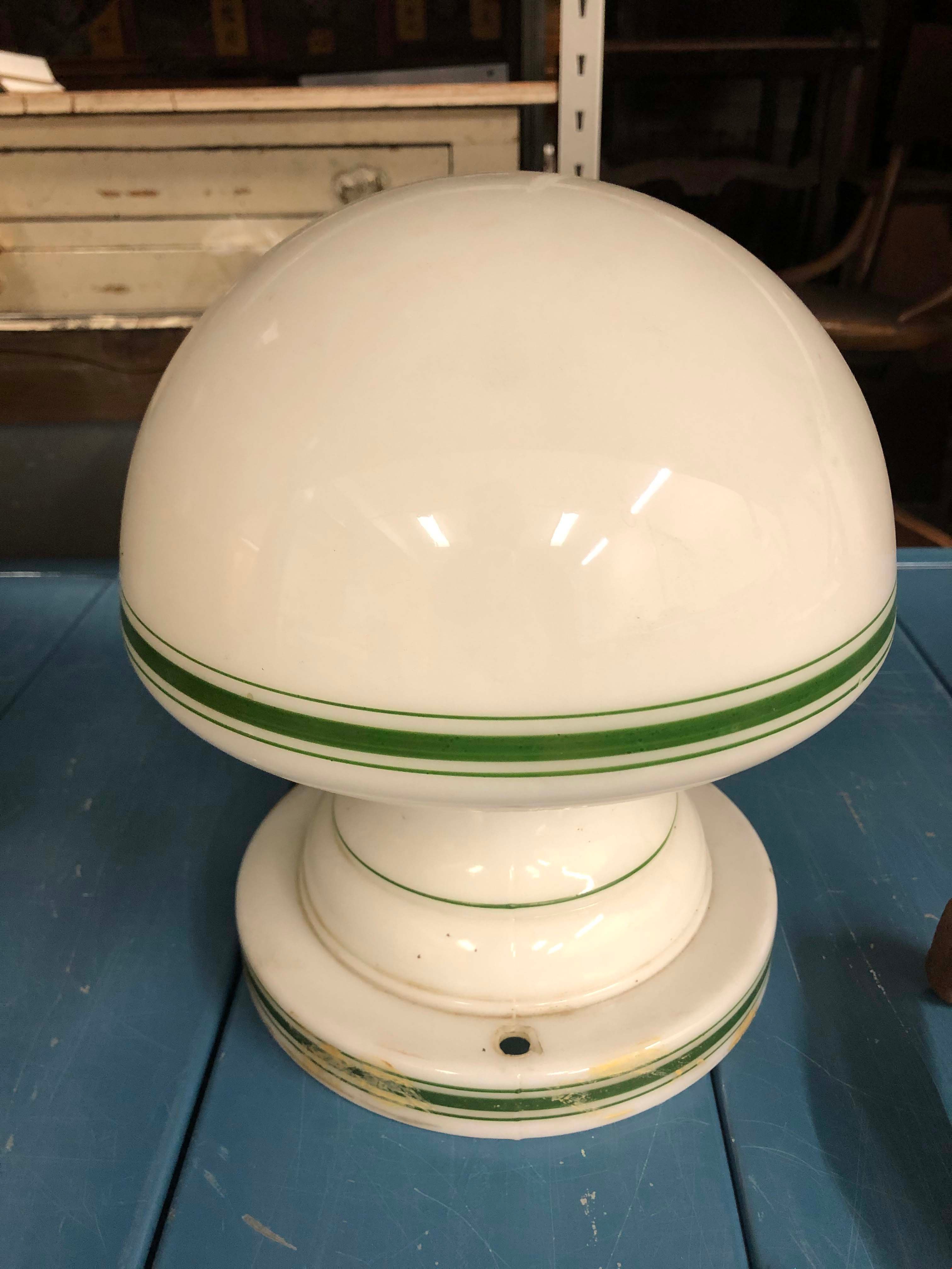
Light Fixture
https://search.heritageburnaby.ca/link/museumartifact90872
- Repository
- Burnaby Village Museum
- Accession Code
- BV020.40.23
- Description
- White glass light fixture with rounded bulb shape. The lamp and the base of the fixture hae a thick green line with two thin lines on either side. There are two holes in the base on opposite sides of each other. There is some tan/beige paint strokes around the base. An additional part is required to actually afix the lamp to the ceiling.
- Object History
- This is an original light fixture for the Eagles House. This house is located on Sperling Avenue and is under the care of the City of Burnaby Planning Department.
- Category
- 02. Furnishings
- Classification
- Lighting Equipment - - Lighting Devices
- Object Term
- Fixture, Lighting
- Colour
- White
- Green
- Historic Neighbourhood
- Burnaby Lake (Historic Neighbourhood)
- Planning Study Area
- Morley-Buckingham Area
Images

Municipality of Burnaby - Volume XV and Volume XVIII
https://search.heritageburnaby.ca/link/museumdescription8680
- Repository
- Burnaby Village Museum
- Date
- May 1927
- Collection/Fonds
- Burnaby Village Museum Map collection
- Description Level
- File
- Physical Description
- 4 plans on 4 sheets : col. lithographic prints ; 63.5 x 53.5 cm folded to 53 x 31.5 cm
- Scope and Content
- File consists of four pages of plans removed from a bound book containing a series of fire insurance plans of the Municipality of Burnaby. The first two pages are numbered "A" and "B" and are key plans from "GREATER VANCOUVER B.C. / VOLUME XV / Surveyed _ May 1927 / MUNICIPALITY OF / BURNABY", "PLA…
- Repository
- Burnaby Village Museum
- Collection/Fonds
- Burnaby Village Museum Map collection
- Description Level
- File
- Physical Description
- 4 plans on 4 sheets : col. lithographic prints ; 63.5 x 53.5 cm folded to 53 x 31.5 cm
- Material Details
- Scales [1:1200] and [1:6000]
- Scope and Content
- File consists of four pages of plans removed from a bound book containing a series of fire insurance plans of the Municipality of Burnaby. The first two pages are numbered "A" and "B" and are key plans from "GREATER VANCOUVER B.C. / VOLUME XV / Surveyed _ May 1927 / MUNICIPALITY OF / BURNABY", "PLAN DEPT. FIRE BRANCH _ B.C. INSURANCE UNDERWRITERS ASSN.". Key Plan "B" covers plans: 1505; 1506; 1512 to 1516; 1540 to 1544; 1550 to 1557 and District Lots: 129 to 132; 135 to 138; 205 to 208 and 215 to 218. Key Plan "A" covers plans: 1501 to 1504; 1507 to 1511; 1517 to 1525; 1531 to 1539; 1545 to 1550 and District Lots: 116 to 127 and 186 to 189. Plan "1806" is part of "GREATER VANCOUVER B.C. / VOLUME XVIII / Municipality of Burnaby / May, 1927" and covers District Lot 153. Plan "1807" is from "GREATER VANCOUVER B.C. / VOLUME XVIII / Municipality of Burnaby / May, 1927" and covers District Lots: 99,149 and 152.
- Responsibility
- British Columbia Underwriters' Association
- Accession Code
- HV972.111.2
- Access Restriction
- No restrictions
- Reproduction Restriction
- May be restricted by third party rights
- Date
- May 1927
- Media Type
- Cartographic Material
- Historic Neighbourhood
- Vancouver Heights (Historic Neighbourhood)
- Lochdale (Historic Neighbourhood)
- Capitol Hill (Historic Neighbourhood)
- Central Park (Historic Neighbourhood)
- Alta Vista (Historic Neighbourhood)
- Planning Study Area
- Burnaby Heights Area
- Sperling-Broadway Area
- Lochdale Area
- Parkcrest-Aubrey Area
- Westridge Area
- Willingdon Heights Area
- Capitol Hill Area
- Maywood Area
- Marlborough Area
- Scan Resolution
- 400
- Scan Date
- 2021-11-18
- Notes
- Title based on content of plans
- Scales are measured 1 inch = 100 feet and 1 inch = 500 feet
- See also BV987.1.70d for revised versions of plans
Zoomable Images


Municipality of Burnaby - Volume XV and Volume XVIII
https://search.heritageburnaby.ca/link/museumdescription8681
- Repository
- Burnaby Village Museum
- Date
- May 1927
- Collection/Fonds
- Burnaby Village Museum Map collection
- Description Level
- File
- Physical Description
- 4 plans on 4 sheets : col. lithographic prints, ms. annotations in blue ink ; 63.5 x 53.5 cm folded to 53 x 31.5 cm
- Scope and Content
- File consists of four pages of plans removed from a bound book containing a series of fire insurance plans of the Municipality of Burnaby. Plan "1507" and plan "1517" are from "GREATER VANCOUVER B.C. / VOLUME XV / Municipality of Burnaby / May, 1927". Plan "1507" covers District Lot 186 and plan "1…
- Repository
- Burnaby Village Museum
- Collection/Fonds
- Burnaby Village Museum Map collection
- Description Level
- File
- Physical Description
- 4 plans on 4 sheets : col. lithographic prints, ms. annotations in blue ink ; 63.5 x 53.5 cm folded to 53 x 31.5 cm
- Material Details
- Scale [1:600] and [1:1200]
- Scope and Content
- File consists of four pages of plans removed from a bound book containing a series of fire insurance plans of the Municipality of Burnaby. Plan "1507" and plan "1517" are from "GREATER VANCOUVER B.C. / VOLUME XV / Municipality of Burnaby / May, 1927". Plan "1507" covers District Lot 186 and plan "1517" covers District Lot 116. Plan "1804" and plan "1805" are from "GREATER VANCOUVER B.C. / VOLUME XVIII / Municipality of Burnaby / May, 1927". Plans "1804" and "1805" cover District Lot 153.
- Responsibility
- British Columbia Underwriters' Association
- Accession Code
- HV972.111.3
- Access Restriction
- No restrictions
- Reproduction Restriction
- May be restricted by third party rights
- Date
- May 1927
- Media Type
- Cartographic Material
- Historic Neighbourhood
- Central Park (Historic Neighbourhood)
- Vancouver Heights (Historic Neighbourhood)
- Planning Study Area
- Maywood Area
- Willingdon Heights Area
- Scan Resolution
- 400
- Scan Date
- 2021-11-18
- Notes
- Title based on content of plans
- See also BV987.1.70d for revised versions of plans
- Scale is measured 1 inch = 100 feet
Images


![Municipality of Burnaby - Volume XV and Volume XVIII, 1927-[1940] thumbnail](/media/hpo/_Data/_BVM_Artifacts/1972/1972_0111_0004_003.jpg?width=280)
Municipality of Burnaby - Volume XV and Volume XVIII
https://search.heritageburnaby.ca/link/museumdescription8682
- Repository
- Burnaby Village Museum
- Date
- 1927-[1940]
- Collection/Fonds
- Burnaby Village Museum Map collection
- Description Level
- File
- Physical Description
- 4 plans on 4 sheets: col. lithographic prints ; 63.5 x 53.5 cm folded to 53 x 31.5 cm
- Scope and Content
- File consists of four pages of plans removed from a bound book containing a series of fire insurance plans of the Municipality of Burnaby. Plan "1518" and "1519" are from "GREATER VANCOUVER B.C. / VOLUME XV / Municipality of Burnaby / May, 1927". Plan "1518" covers District Lot 116 and Plan "1519"…
- Repository
- Burnaby Village Museum
- Collection/Fonds
- Burnaby Village Museum Map collection
- Description Level
- File
- Physical Description
- 4 plans on 4 sheets: col. lithographic prints ; 63.5 x 53.5 cm folded to 53 x 31.5 cm
- Material Details
- Scale [1:600]
- Scope and Content
- File consists of four pages of plans removed from a bound book containing a series of fire insurance plans of the Municipality of Burnaby. Plan "1518" and "1519" are from "GREATER VANCOUVER B.C. / VOLUME XV / Municipality of Burnaby / May, 1927". Plan "1518" covers District Lot 116 and Plan "1519" covers District Lot 121. Plan "1802" and plan "1803" are from "GREATER VANCOUVER B.C. / VOLUME XVIII / Municipality of Burnaby / May, 1927". Both plans "1802" and "1803" cover District Lot 153.
- Responsibility
- British Columbia Underwriters' Association
- Accession Code
- HV972.111.4
- Access Restriction
- No restrictions
- Reproduction Restriction
- May be restricted by third party rights
- Date
- 1927-[1940]
- Media Type
- Cartographic Material
- Historic Neighbourhood
- Vancouver Heights (Historic Neighbourhood)
- Central Park (Historic Neighbourhood)
- Planning Study Area
- Willingdon Heights Area
- Marlborough Area
- Scan Resolution
- 400
- Scan Date
- 2021-11-18
- Notes
- Title based on content of plans
- See also BV987.1.70d for revised versions of plans
- Scale is measured 1 inch = 50 feet
- Contact Burnaby Village Museum to access plans 1518 and 1519 (these plans have revisions on top - date of revisions is uncertain)
Images
![Municipality of Burnaby - Volume XV and Volume XVIII, 1927-[1940] thumbnail](/media/hpo/_Data/_BVM_Artifacts/1972/1972_0111_0004_003.jpg)


Municipality of Burnaby- Volume XV and Volume XVIII
https://search.heritageburnaby.ca/link/museumdescription8686
- Repository
- Burnaby Village Museum
- Date
- May 1927
- Collection/Fonds
- Burnaby Village Museum Map collection
- Description Level
- File
- Physical Description
- 4 plans on 4 sheets : col. lithographic prints ; 63.5 x 53.5 cm folded to 53 x 31.5 cm
- Scope and Content
- File consists of four pages of plans removed from a bound book containing a series of fire insurance plans of the Municipality of Burnaby. Plan "1520" is part of "GREATER VANCOUVER B.C. / VOLUME XV / Municipality of Burnaby / May 1927" and covers District Lots: 121 and 187. Plann "1521" is part of …
- Repository
- Burnaby Village Museum
- Collection/Fonds
- Burnaby Village Museum Map collection
- Description Level
- File
- Physical Description
- 4 plans on 4 sheets : col. lithographic prints ; 63.5 x 53.5 cm folded to 53 x 31.5 cm
- Material Details
- Scale [1:600] and [1:1200]
- Scope and Content
- File consists of four pages of plans removed from a bound book containing a series of fire insurance plans of the Municipality of Burnaby. Plan "1520" is part of "GREATER VANCOUVER B.C. / VOLUME XV / Municipality of Burnaby / May 1927" and covers District Lots: 121 and 187. Plann "1521" is part of "GREATER VANCOUVER B.C. / VOLUME XV / Municipality of Burnaby / May 1927" and covers District Lots: 121 and 187. Key plan "H" reads: "GREATER VANCOUVER B.C. / VOLUME XVIII / Surveyed _ May 1927 / MUNICIPALITY OF / BURNABY" and covers plans: 1813 to 1822; 1824 to 1832; 1839; 1840; 1853 to 1865 and District Lots: 28; 30; 53; 90 to 93; 95 to 97; 155a; 155b; 155c; 159; 160; 171 to 173. Plan "1801" is part of "GREATER VANCOUVER B.C. / VOLUME XVIII / Municipality of Burnaby / May 1927" and covers District Lot 153.
- Responsibility
- British Columbia Underwriters' Association
- Accession Code
- HV972.111.8
- Access Restriction
- No restrictions
- Reproduction Restriction
- May be restricted by third party rights
- Date
- May 1927
- Media Type
- Cartographic Material
- Historic Neighbourhood
- Fraser Arm (Historic Neighbourhood)
- Vancouver Heights (Historic Neighbourhood)
- East Burnaby (Historic Neighbourhood)
- Edmonds (Historic Neighbourhood)
- Planning Study Area
- Marlborough Area
- Kingsway-Beresford Area
- Windsor Area
- Big Bend Area
- Clinton-Glenwood Area
- Burnaby Heights Area
- Edmonds Area
- Stride Avenue Area
- Scan Resolution
- 400
- Scan Date
- 2021-11-18
- Notes
- Title based on content of plans
- See also BV987.1.70d for revised versions of plans
- Scale is measured 1 inch = 500 feet
Zoomable Images


Municipality of Burnaby - Volume XVI and Volume XVII
https://search.heritageburnaby.ca/link/museumdescription8684
- Repository
- Burnaby Village Museum
- Date
- May 1927
- Collection/Fonds
- Burnaby Village Museum Map collection
- Description Level
- File
- Physical Description
- 4 plans on 4 sheets : col. lithographic prints ; 63.5 x 53.5 cm folded to 53 x 31.5 cm
- Scope and Content
- File consists of four pages of plans removed from a bound book containing a series of fire insurance plans of the Municipality of Burnaby. Page "D" is titled: "GREATER VANCOUVER B.C. / VOLUME XVI / Surveyed _ May 1927 / MUNICIPALITY OF / BURNABY / PLAN DEPT. FIRE BRANCH _ B.C. INSURANCE UNDERWRITE…
- Repository
- Burnaby Village Museum
- Collection/Fonds
- Burnaby Village Museum Map collection
- Description Level
- File
- Physical Description
- 4 plans on 4 sheets : col. lithographic prints ; 63.5 x 53.5 cm folded to 53 x 31.5 cm
- Material Details
- Scale [1:1200] and [1:6000]
- Scope and Content
- File consists of four pages of plans removed from a bound book containing a series of fire insurance plans of the Municipality of Burnaby. Page "D" is titled: "GREATER VANCOUVER B.C. / VOLUME XVI / Surveyed _ May 1927 / MUNICIPALITY OF / BURNABY / PLAN DEPT. FIRE BRANCH _ B.C. INSURANCE UNDERWRITERS ASSN." / KEY PLAN". Plans covered in this "Key Plan" are numbered 1601 to 1626, 1632 and 1651 covering District Lots: 15; 31; 100 to 102; 114; 141 to 144; 147 and 148; 209 to 214. Plan "E" is part of "GREATER VANCOUVER B.C. / VOLUME XVII / Municipality of Burnaby / May 1927" and covers plans: 1701 to 1705; 1711 to 1715; 1723 to 1727; 1729 to 1733; 1737 to 1742 and District Lots: 68 to 74; 80 to 84; 32 to 35 and 38 to 39. Plan marked "F" is a key plan titled: "GREATER VANCOUVER B.C. / VOLUME XVII / Surveyed _ May 1927 / MUNICIPALITY OF / BURNABY and covers plans: 1706 to 1710; 1716 to 1722; 1734 and 1735; 1743 to 1752 and District Lots: 42 to 44; 59; 75 to 80; 83 to 87; 89 to 93 and 130. Plan "1729" is part of "GREATER VANCOUVER B.C. / VOLUME XVII / Municipality of Burnaby / May 1927" and covers District Lots 34 and 35.
- Responsibility
- British Columbia Underwriters' Association
- Accession Code
- HV972.111.6
- Access Restriction
- No restrictions
- Reproduction Restriction
- May be restricted by third party rights
- Date
- May 1927
- Media Type
- Cartographic Material
- Historic Neighbourhood
- Barnet (Historic Neighbourhood)
- Burquitlam (Historic Neighbourhood)
- Central Park (Historic Neighbourhood)
- Burnaby Lake (Historic Neighbourhood)
- Broadview (Historic Neighbourhood)
- Planning Study Area
- Burnaby Mountain Area
- Lyndhurst Area
- Lake City Area
- Cascade-Schou Area
- Garden Village Area
- Douglas-Gilpin Area
- Oakalla Area
- Scan Resolution
- 400
- Scan Date
- 2021-11-18
- Notes
- Title based on content of plans
- See also BV987.1.70d for revised versions of plans
- Scale is measured 1 inch = 500 feet
Zoomable Images


Municipality of Burnaby - Volume XVIII
https://search.heritageburnaby.ca/link/museumdescription8687
- Repository
- Burnaby Village Museum
- Date
- May 1927
- Collection/Fonds
- Burnaby Village Museum Map collection
- Description Level
- File
- Physical Description
- 2 plans on 2 sheets : col. lithographic prints; 63.5 x 53.5 cm folded to 53 x 31.5 cm
- Scope and Content
- File consists of two pages of plans removed from a bound book containing a series of fire insurance plans of the Municipality of Burnaby. Plan "1819" and Plan "1820 are part of "GREATER VANCOUVER B.C. / VOLUME XVIII / Municipality of Burnaby / May 1927. Plan "1819" covers District Lot 95 and plan …
- Repository
- Burnaby Village Museum
- Collection/Fonds
- Burnaby Village Museum Map collection
- Description Level
- File
- Physical Description
- 2 plans on 2 sheets : col. lithographic prints; 63.5 x 53.5 cm folded to 53 x 31.5 cm
- Material Details
- Scales [1:600]
- Scope and Content
- File consists of two pages of plans removed from a bound book containing a series of fire insurance plans of the Municipality of Burnaby. Plan "1819" and Plan "1820 are part of "GREATER VANCOUVER B.C. / VOLUME XVIII / Municipality of Burnaby / May 1927. Plan "1819" covers District Lot 95 and plan "1820" covers District Lots 30 and 95.
- Responsibility
- British Columbia Underwriters' Association
- Accession Code
- HV972.111.38
- Access Restriction
- No restrictions
- Reproduction Restriction
- May be restricted by third party rights
- Date
- May 1927
- Media Type
- Cartographic Material
- Historic Neighbourhood
- Edmonds (Historic Neighbourhood)
- Highland Park (Historic Neighbourhood)
- Planning Study Area
- Stride Hill Area
- Kingsway-Beresford Area
- Scan Resolution
- 400
- Scan Date
- 2021-11-18
- Notes
- Title based on content of plans
- Scales are measured 1 inch = 50 feet
- See also BV987.1.70d for revised versions of plans
Images

