![Boathouse on Burnaby Lake, [1902] thumbnail](/media/hpo/_Data/_Archives_Images/_Unrestricted/477/477-855.jpg?width=280)
Boathouse on Burnaby Lake
https://search.heritageburnaby.ca/link/archivedescription39536
- Repository
- City of Burnaby Archives
- Date
- [1902]
- Collection/Fonds
- Peers Family and Hill Family fonds
- Description Level
- Item
- Physical Description
- 1 photograph : b&w 5.5 x 7.5 cm on page 21.5 x 28 cm (pasted in album)
- Scope and Content
- Photograph of Bernard Hill's boathouse on Burnaby Lake. Built in 1902, the boathouse was located on Deer Lake Brook at the southwestern tip of Burnaby Lake.
- Repository
- City of Burnaby Archives
- Date
- [1902]
- Collection/Fonds
- Peers Family and Hill Family fonds
- Physical Description
- 1 photograph : b&w 5.5 x 7.5 cm on page 21.5 x 28 cm (pasted in album)
- Description Level
- Item
- Record No.
- 477-855
- Access Restriction
- No restrictions
- Reproduction Restriction
- No known restrictions
- Accession Number
- 2007-12
- Scope and Content
- Photograph of Bernard Hill's boathouse on Burnaby Lake. Built in 1902, the boathouse was located on Deer Lake Brook at the southwestern tip of Burnaby Lake.
- Subjects
- Buildings - Residential - Boathouses
- Media Type
- Photograph
- Notes
- Title based on caption accompanying photograph
- Geographic Access
- Burnaby Lake
- Deer Lake Brook
- Historic Neighbourhood
- Burnaby Lake (Historic Neighbourhood)
Images
![Boathouse on Burnaby Lake, [1902] thumbnail](/media/hpo/_Data/_Archives_Images/_Unrestricted/477/477-855.jpg)
![E.B. Wetenhall and Kitty Hill, [1902] thumbnail](/media/hpo/_Data/_Archives_Images/_Unrestricted/477/477-100.jpg?width=280)
E.B. Wetenhall and Kitty Hill
https://search.heritageburnaby.ca/link/archivedescription38781
- Repository
- City of Burnaby Archives
- Date
- [1902]
- Collection/Fonds
- Peers Family and Hill Family fonds
- Description Level
- Item
- Physical Description
- 1 photograph : b&w ; 6 x 8 cm on page 11.5 x 14 cm (pasted in album)
- Scope and Content
- Photograph of E.B. Wetenhall leading a horse to water. Kitty Hill is the foreground and a wooden trestle bridge spans Deer Lake Brook in the background.
- Repository
- City of Burnaby Archives
- Date
- [1902]
- Collection/Fonds
- Peers Family and Hill Family fonds
- Physical Description
- 1 photograph : b&w ; 6 x 8 cm on page 11.5 x 14 cm (pasted in album)
- Description Level
- Item
- Record No.
- 477-100
- Access Restriction
- No restrictions
- Reproduction Restriction
- No known restrictions
- Accession Number
- 2007-12
- Scope and Content
- Photograph of E.B. Wetenhall leading a horse to water. Kitty Hill is the foreground and a wooden trestle bridge spans Deer Lake Brook in the background.
- Media Type
- Photograph
- Notes
- Title based on contents of photograph
- Geographic Access
- Deer Lake Brook
- Deer Lake Avenue
- Street Address
- 6501 Deer Lake Avenue
- Historic Neighbourhood
- Burnaby Lake (Historic Neighbourhood)
- Planning Study Area
- Morley-Buckingham Area
Images
![E.B. Wetenhall and Kitty Hill, [1902] thumbnail](/media/hpo/_Data/_Archives_Images/_Unrestricted/477/477-100.jpg)
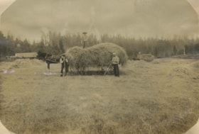
Haying at Broadview
https://search.heritageburnaby.ca/link/archivedescription39551
- Repository
- City of Burnaby Archives
- Date
- 1906
- Collection/Fonds
- Peers Family and Hill Family fonds
- Description Level
- Item
- Physical Description
- 1 photograph : b&w ; 11 x 16 cm on page 21.5 x 28 cm (pasted in album)
- Scope and Content
- Photograph of farmers in the field gathering hay with horse and wagons. In the middle of the photograph three men pose with a horse and hay wagon. The man on the right (with white shirt) is Bernard Hill. The bearded man may be Malcolm Nicholson (from whom Claude Hill bought the land to build his h…
- Repository
- City of Burnaby Archives
- Date
- 1906
- Collection/Fonds
- Peers Family and Hill Family fonds
- Physical Description
- 1 photograph : b&w ; 11 x 16 cm on page 21.5 x 28 cm (pasted in album)
- Description Level
- Item
- Record No.
- 477-870
- Access Restriction
- No restrictions
- Reproduction Restriction
- No known restrictions
- Accession Number
- 2007-12
- Scope and Content
- Photograph of farmers in the field gathering hay with horse and wagons. In the middle of the photograph three men pose with a horse and hay wagon. The man on the right (with white shirt) is Bernard Hill. The bearded man may be Malcolm Nicholson (from whom Claude Hill bought the land to build his home, Broadview). The other man is unidentified. This photograph was taken on the Broadview site, looking south, roughly at the corner of Sperling Avenue and Rugby Avenue, towards Buckingham Avenue.
- Names
- Hill, Bernard R.
- Media Type
- Photograph
- Notes
- Title based on contents of photograph
- Geographic Access
- Buckingham Avenue
- Sperling Avenue
- Rugby Street
- Historic Neighbourhood
- Burnaby Lake (Historic Neighbourhood)
- Planning Study Area
- Morley-Buckingham Area
Images


Looking south from Bernard Hill's house
https://search.heritageburnaby.ca/link/archivedescription39527
- Repository
- City of Burnaby Archives
- Date
- 1906
- Collection/Fonds
- Peers Family and Hill Family fonds
- Description Level
- Item
- Physical Description
- 1 photograph : b&w ; 11.8 x 17 cm on page 21.5 x 28 cm (pasted in album)
- Scope and Content
- Photograph of the fields and farmland looking southeast from the home of Bernard Hill down Douglas Road towards Deer Lake Brook. In the foreground view can be seen what is the present-day Kensington Avenue freeway entrance and No. 1 Firehall site on Sperling Avenue. The cabin that can be seen to …
- Repository
- City of Burnaby Archives
- Date
- 1906
- Collection/Fonds
- Peers Family and Hill Family fonds
- Physical Description
- 1 photograph : b&w ; 11.8 x 17 cm on page 21.5 x 28 cm (pasted in album)
- Description Level
- Item
- Record No.
- 477-846
- Access Restriction
- No restrictions
- Reproduction Restriction
- No known restrictions
- Accession Number
- 2007-12
- Scope and Content
- Photograph of the fields and farmland looking southeast from the home of Bernard Hill down Douglas Road towards Deer Lake Brook. In the foreground view can be seen what is the present-day Kensington Avenue freeway entrance and No. 1 Firehall site on Sperling Avenue. The cabin that can be seen to the left in the background is an unknown residence further along Douglas Road near Rayside Drive and the cabin that is just visible in the centre background of the photograph (between treeline split) belonged to Mr. Nicholson. It was later torn down when Bernard Hill's brother Claude Hill built his home, Broadview at that location. To the extreme right of the picture on the opposite side of Douglas Road is the property of Claude Hill's first Burnaby home also known as Brookfield (the current location of the Burnaby Village Museum).
- Subjects
- Agriculture - Farms
- Media Type
- Photograph
- Notes
- Title based on caption accompanying photograph
- Geographic Access
- Douglas Road
- Canada Way
- Deer Lake Brook
- Street Address
- 4990 Canada Way
- Historic Neighbourhood
- Burnaby Lake (Historic Neighbourhood)
- Planning Study Area
- Douglas-Gilpin Area
Images
