Narrow Results By
Subject
- Buildings 2
- Buildings - Commercial 2
- Buildings - Commercial - Hotels and Motels 1
- Buildings - Commercial - Theatres 1
- Buildings - Schools 9
- Documentary Artifacts 12
- Documentary Artifacts - Cards 1
- Documentary Artifacts - Certificates 2
- Documentary Artifacts - Letters and Envelopes 3
- Documentary Artifacts - Licenses 1
- Documentary Artifacts - Photographs 4
- Documentary Artifacts - Postcards 4
Person / Organization
- Armstrong Avenue School 1
- Barnet School 1
- British Columbia Provincial Police 1
- Burnaby Mountain Centennial Park 1
- Coe, Eric 1
- Descoteau, Norah Irene Byrne 1
- Douglas Road School 1
- Gilmore Avenue School 1
- Great Northern Railway 1
- Hamilton Road School 1
- Hill, Louis Claude "Claude" 1
- Inman Avenue School 1

Armstrong Street School site
https://search.heritageburnaby.ca/link/museumdescription11133
- Repository
- Burnaby Village Museum
- Date
- 1915
- Collection/Fonds
- Ronald G. Scobbie collection
- Description Level
- Item
- Physical Description
- 1 survey plan : blueprint on paper ; 56 x 54 cm
- Scope and Content
- Survey plan of "Armstrong Street School Site / Burnaby Municipality" "Being a 2 acre portion of Lot 13 Group 1, & according to map 1722 which shows this as Lot E. Block 2 of subdivision of a portion, of Lot 13, Group 1, New Westminster District".
- Repository
- Burnaby Village Museum
- Collection/Fonds
- Ronald G. Scobbie collection
- Description Level
- Item
- Physical Description
- 1 survey plan : blueprint on paper ; 56 x 54 cm
- Material Details
- Scale 40 feet = 1 inch
- Scope and Content
- Survey plan of "Armstrong Street School Site / Burnaby Municipality" "Being a 2 acre portion of Lot 13 Group 1, & according to map 1722 which shows this as Lot E. Block 2 of subdivision of a portion, of Lot 13, Group 1, New Westminster District".
- Creator
- Burnett, Geoffrey K.
- Subjects
- Buildings - Schools
- Names
- Armstrong Avenue School
- Responsibility
- Burnett & McGugan, Engineers and Surveyors
- Geographic Access
- Armstrong Avenue
- Street Address
- 8757 Armstrong Avenue
- Accession Code
- BV003.83.12
- Access Restriction
- No restrictions
- Reproduction Restriction
- No known restrictions
- Date
- 1915
- Media Type
- Cartographic Material
- Historic Neighbourhood
- East Burnaby (Historic Neighbourhood)
- Planning Study Area
- Cariboo-Armstrong Area
- Scan Resolution
- 440
- Scan Date
- 22-Dec-2020
- Scale
- 100
- Notes
- Title based on contents of plan
- Note in black ink on verso of plan reads: "1746"
- Oath on plan reads: "I, Geoffrey K. Burnett...and did personally superintend the survey represented..." "Completed on the 18th day of March 1915"; signed by Geoffrey K. Burnett and notarized by "K.A. Eastman", sworn "...19th day of April 1915"; "Burnett and McGugan., B.C. Land Surveyors. Etc.. New Westminster, B.C.."
Zoomable Images


Barnet School site
https://search.heritageburnaby.ca/link/museumdescription11140
- Repository
- Burnaby Village Museum
- Date
- May 27, 1915
- Collection/Fonds
- Ronald G. Scobbie collection
- Description Level
- Item
- Physical Description
- 1 survey plan : blueprint on paper ; 56 x 54 cm
- Scope and Content
- Survey plan of "Barnet School Site / Burnaby Municipality" "Being a portion of the west half of lot / 214, Group 1 / New Westminster District”.
- Repository
- Burnaby Village Museum
- Collection/Fonds
- Ronald G. Scobbie collection
- Description Level
- Item
- Physical Description
- 1 survey plan : blueprint on paper ; 56 x 54 cm
- Material Details
- Scale 40 feet = 1 inch
- Scope and Content
- Survey plan of "Barnet School Site / Burnaby Municipality" "Being a portion of the west half of lot / 214, Group 1 / New Westminster District”.
- Creator
- McGugan, Donald Johnston
- Subjects
- Buildings - Schools
- Names
- Barnet School
- Responsibility
- Burnett & McGugan, Engineers and Surveyors
- Geographic Access
- Barnet Road
- Street Address
- 7820 Barnet Road
- Accession Code
- BV003.83.19
- Access Restriction
- No restrictions
- Reproduction Restriction
- No known restrictions
- Date
- May 27, 1915
- Media Type
- Cartographic Material
- Historic Neighbourhood
- Barnet (Historic Neighbourhood)
- Planning Study Area
- Burnaby Mountain Area
- Scan Resolution
- 440
- Scan Date
- 22-Dec-2020
- Scale
- 100
- Notes
- Title based on contents of plan
- handwritten on back "Burnaby Schools" "23R" twice, "1783"
- Oath on plan reads: "I, D.J. McGugan...and did personally superintend the survey..." "completed on the 27th day of May 1915"; signed by D.J. McGugan, notarized by "Walter Edmonds" "sworn "...29th day of May 1915" "Burnett and McGugan" "B.C. Land Surveyors Etc. New Westminster, B.C.";
Zoomable Images


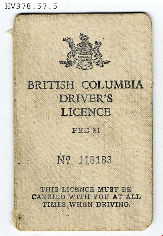
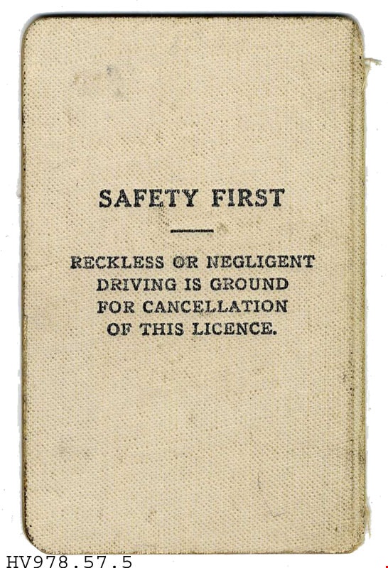
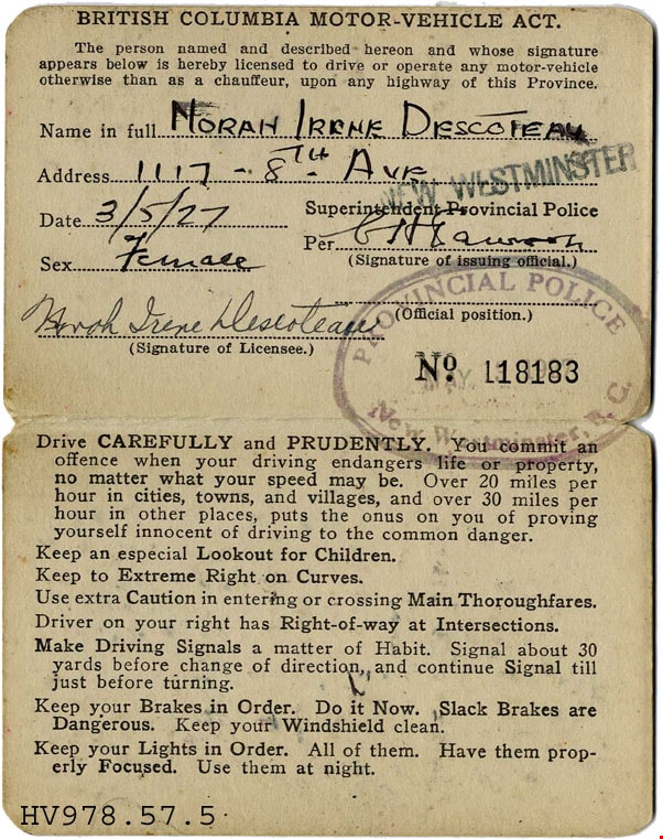
B C driver's licence
https://search.heritageburnaby.ca/link/museumartifact18261
- Repository
- Burnaby Village Museum
- Accession Code
- HV978.57.5
- Description
- British Columbia Driver's Licence -(License) -- [1927]. Driver's Licence issued to Norah Irene Descoteau in 1927. The front cover has the Provincial Coat of Arms and the issue number for the licence "No. 118183". It states that "The Licence Must Be Carried With You At All Times When Driving". Inside provides detailed infromation about Norah and rules and regulations to driving. The license has been stamped by the Provincial Police in New Westminster, B.C.
- Object History
- From the estate of Norah Byrne, daughter of Peter Byrne and Priscilla Amelia Rowling Rowling. She married William Napoleon Descoteau on May 28th 1924 in New Westminster. William worked as a steam engineer on the railroad.
Images
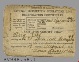
card
https://search.heritageburnaby.ca/link/museumartifact39322
- Repository
- Burnaby Village Museum
- Accession Code
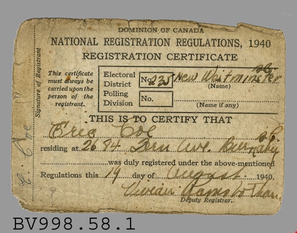
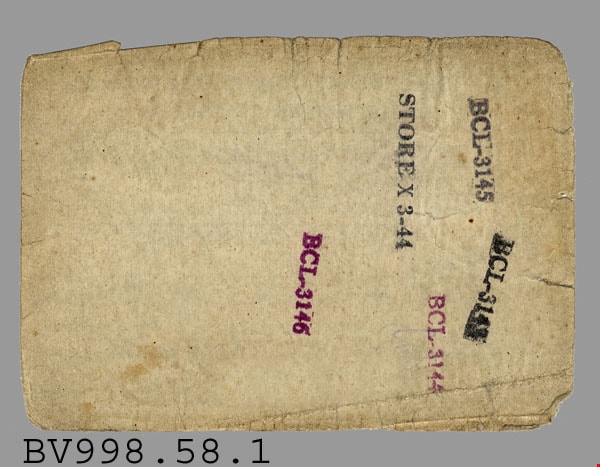
- BV998.58.1
- Description
- National Registration Regulations - Card -- [1940]. Dominion of Canada National Registration Card for Eric Coe of 2684 Fern Avenue, Burnaby. Eric Coe was Part of the Electoral District Number 235 New Westminster, B.C. The registration card was signed on August 19th, 1940 and was signed by Deputy Registrar Vivean Ramsbothan (?). On the back of the card are several ink stamps "BCL-3143", "BCL-3144", "BCL-3145", "BCL 3146" and "STORE X 3-44". The card measures 10cm x 7cm.
- Colour
- White
- Names
- Coe, Eric
Images
certificate
https://search.heritageburnaby.ca/link/museumartifact34753
- Repository
- Burnaby Village Museum
- Accession Code
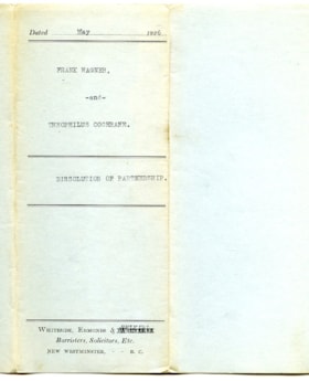
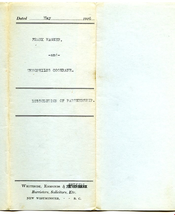
- BV992.45.1
- Description
- Dissolution of Partnership - Certificate -- [1926]. Certificate, four typed pages in blue paper cover, folded twice; typed on cover to show when folded, "FRANK WAGNER," "-and-" "THEOPHILUS COCHRANE." "DISSOLUTION OF PARTNERSHIP."; preprinted with borders top and bottom; above upper border, "Dated" and dotted line, "19" at right, has been typed in as May, 1926; two borders at middle, title has been typed between; below bottom border, "WHITESIDE, EDMONDS & WHITESIDE" "Barristers, Solicitors, Etc." "NEW WESTMINSTER, - - B.C."; 2nd 'Whiteside' is 'X'ed out by typewriter, "SELKIRL"? typed above it; form begins "THIS INDENTURE made the", then handwritten "Tenth", then typed "day of May,..."; signed by both parties, red seals; witnessed by John Murray, broker, 4009 Kingsway, Burnaby; paper is very thin, blue margin at left, watermark "MAPLE LEAF" and U and T
- Category
- 08. Communication Artifacts
- Classification
- Documentary Artifacts - - Legal Documents
- Colour
- Blue
- Names
- Wagner, Frank
Images

certificate and envelope
https://search.heritageburnaby.ca/link/museumartifact38387
- Repository
- Burnaby Village Museum
- Accession Code
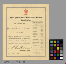
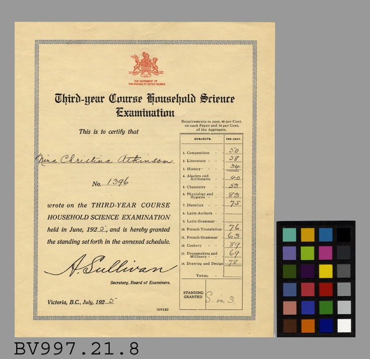
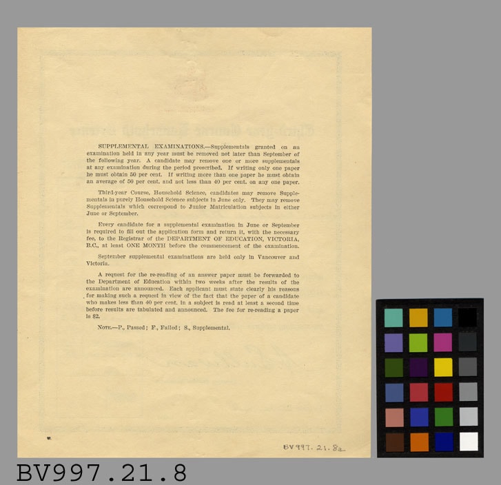
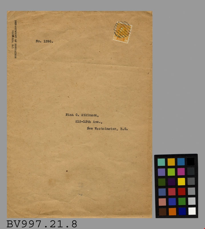
- BV997.21.8
- Description
- Third Year Course Household Science Examination - Certificate and Envelope -- [1925]. Third Year Course Household Science Examination Certificate for Nina Christina Atkinson, No. 1396. The examination was held in June 1925. Nina was tested in Composition, Literature, History, Algebra and Arithmetic, Chemistry, Physiology and Hygiene, Dietetics, French Translation, French Grammar, Cookery, Dressmaking and Millinery, and finally Drawing and Design. In red at the top of the certificate is the Coat of Arms for British Columbia and written below is "The Government of the Province of British Columbia. On the reverse side is information on supplement examinations. The certificate measures 18cm x 22cm. The envelope is brown paper addressed to Nina C. Atkinson, at 215-13th Ave., New Westminster, B.C.. The envelope has an orange King George V stamp on the top right corner and "Department of Education/ Victoria, B.C." written on the top left corner. The envelope has a butterfly enclosure and measures 19cm x 27cm.
- Colour
- Beige
Images
certificate and envelope
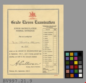
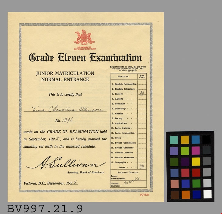
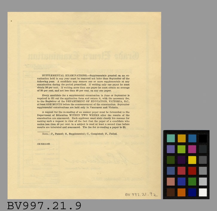
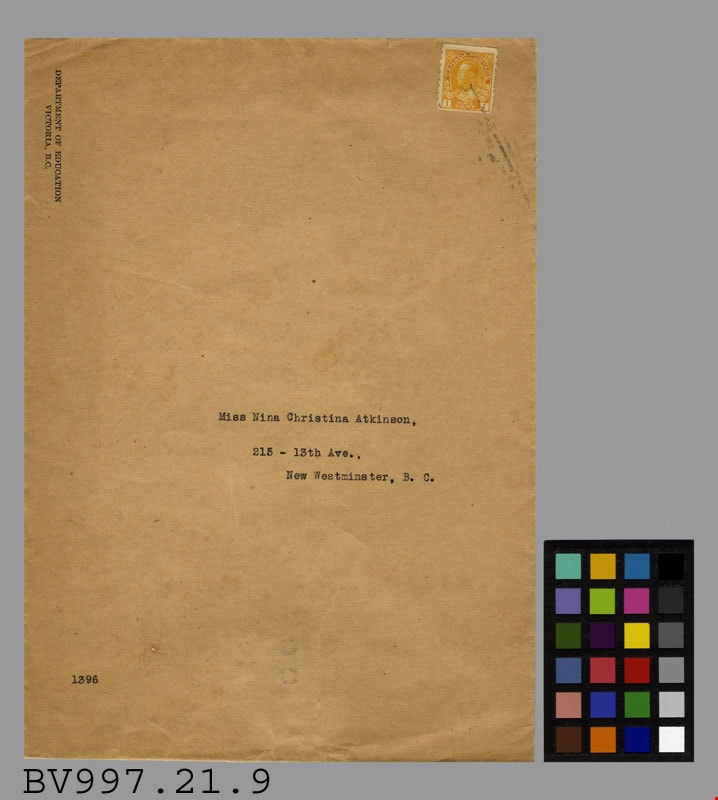
https://search.heritageburnaby.ca/link/museumartifact38395
- Repository
- Burnaby Village Museum
- Accession Code
- BV997.21.9
- Description
- Grade Eleven Examination - Certificate and Envelope -- [1925]. Grade Eleven Examination for Junior Matriculation Normal Entrance for Nina Christina Atkinson, No. 1396. The exam was taken in September of 1925. The only subject that Nina wrote on was History. In red at the top of the certificate is the Coat of Arms for the Province of British Columbia. Below the coat of arms is "The Government of the Province of British Columbia". On the reverse side of the certificate is information on supplemental examinations. The certificate measures 18.5cm x 22.5cm. The envelope is brown paper and was addressed to Miss Nina Christina Atkinson, 215 - 13th Ave., New Westminster, B.C.. The envelope was from the Department of Education in Victoria, B.C. and has an orange King George V stamp on the top right corner. The envelope has a butterfly enclosure and measures 19cm x 27cm.
- Object History
- Artifact 9a was received in artifact 9b
- Colour
- Beige
Images

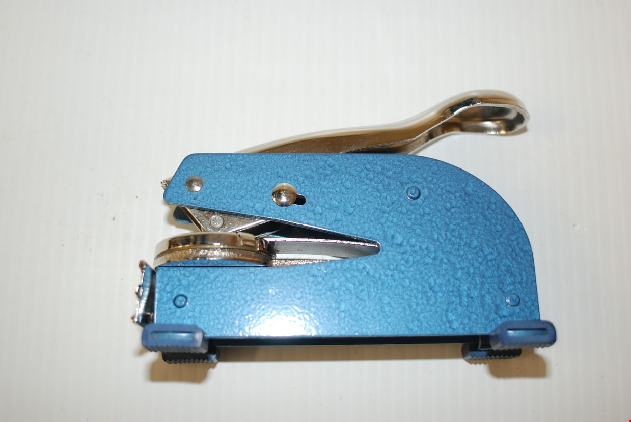
company seal with box
https://search.heritageburnaby.ca/link/museumartifact81963
- Repository
- Burnaby Village Museum
- Accession Code
- BV012.14.36
- Description
- A steel seal stamp machine with a blue painted body and silver lever. The seal is circular in shape. Four rubber feet are present. A name plate holding a card printed with "JOHN YANKO TILE CO. LTD." is attached at the front of the stamp. The cardboard box is white with "SEALS & EMBOSSERS OFFICIAL" printed continuously over it. The name "JOHN" is printed in handwritten ink. Markings on the lever: "OFFICIAL LONG REACH PAT.2,706 448" A sticker on the underside reads: "Westamp TELEPHONE 521-4448 or 521-1722 35 - 8th Ave, New Westminster, B.C. V3L 1X6" The stamp imprints along the perimeter of the circle: "JOHN YANKO TILE CO. LTD." with a 5 pointed star. In the middle "SEAL".
- Object History
- Hand tools used by John Yanko in his business as a tile setter. Annie D. Basiuk (later Yanko) was born on February 25, 1902 in Sheho, Saskatchewan (formerly Sheho, North West Territories). Daniel "Dan" Yanko was born in Kobilnicha, Ukraine in 1887 and immigrated to Canada in May or June of 1905. Daniel Yanko married Annie D. Basiuk and had thirteen children together. Their son, John Ivan Yanko was born on the family farm, near Kelliher, Saskatchewan, on June 27, 1923. In grade six, John was pulled out of school to help support the family. Eugenia “Jenny” Haresomovych (later Carman) was born August 8, 1904 in Galecia, Austria. She came to Canada in 1928, when her parents sent her to live with the Austrian consular in Halifax. A year later, she was in The Pas with Albert Edward Carman, with whom she would have three children. Their daughter, Leida Doria "Lillian Doris" Carman was born in The Pas, Manitoba March 24, 1929. Eugenia “Jenny” (Haresomovych) Carman later re-married Joseph Nagy who was born in Hungary in October 3, 1900. Jenny, Joseph and the children moved to Nelson, British Columbia, where Joseph worked for the Canadian Pacific Railway. At the age of twenty, John Yanko met his future wife Lillian Doris Carman while visiting relatives in Burnaby. Lillian received a rail pass because of her dad’s employment with the CPR and at fourteen had gone to visit her Godmother in Burnaby. John Ivan Yanko and Leida Doria "Lillian Doris" Carman were married October 16, 1948 in Nelson, British Columbia and moved into the basement of John’s sister’s house on Union Street. Lillian began working at the downtown Woodward’s store as a cashier in 1948. In 1950, the young couple bought property at 7385 (later renumbered 7391) Broadway in Burnaby and began constructing a house as they could afford it. Knowing she’d be let go if she was pregnant, when Lillian was expecting her first child, Jenny sewed her several versions of the same outfit; they all used the same material, but each was a little bit larger than the last to accommodate her expanding girth. Rhonda, born in 1953 and Charmaine, born in 1955, grew up in the Broadway home. They attended school at Sperling Elementary, and later at Burnaby North high school. Lillian left her job to be a stay-at-home mom when Rhonda was born, but that changed in 1963 when John and Charmaine were in a car accident that left John temporarily unable to work. Joseph Nagy died April 20, 1962; his wife Eugenia “Jenny” (Haresomovych) (Carman) Nagy passed away August 14, 1985. Daniel "Dan" Yanko died in 1976; his wife Annie D. (Basiuk) Yanko died in 1997. John Yanko later returned to work, establishing his own tile setting business and working until age eighty-two. John and Lillian lived out the rest of their married lives on the Broadway property. John Ivan Yanko passed away in 2010; his wife Leida Doria "Lillian Doris" Carman (Carman) Yanko passed away in 2011.
- Measurements
- Overall measurements: Length: 14.5 cm Width: 5.4 cm Height (handle open: 18.7 cm)
- Names
- Yanko, John Ivan
- Yanko Family
Images

Douglas Road School site
https://search.heritageburnaby.ca/link/museumdescription11136
- Repository
- Burnaby Village Museum
- Date
- April 19, 1915
- Collection/Fonds
- Ronald G. Scobbie collection
- Description Level
- Item
- Physical Description
- 1 survey plan : blueprint on paper ; 56 x 54 cm
- Scope and Content
- Survey plan of "Douglas Road School Site / Burnaby Municipality" "Being Lot 21, of Blocks 1-5 inc. 11 & 12 of the subd. of north half of Lot 80, Group 1, New Westminster District".
- Repository
- Burnaby Village Museum
- Collection/Fonds
- Ronald G. Scobbie collection
- Description Level
- Item
- Physical Description
- 1 survey plan : blueprint on paper ; 56 x 54 cm
- Material Details
- Scale 40 feet = 1 inch
- Scope and Content
- Survey plan of "Douglas Road School Site / Burnaby Municipality" "Being Lot 21, of Blocks 1-5 inc. 11 & 12 of the subd. of north half of Lot 80, Group 1, New Westminster District".
- Creator
- McGugan, Donald Johnston
- Subjects
- Buildings - Schools
- Names
- Douglas Road School
- Responsibility
- Burnett & McGugan, Engineers and Surveyors
- Geographic Access
- Canada Way
- Street Address
- 4861 Canada Way
- Accession Code
- BV003.83.15
- Access Restriction
- No restrictions
- Reproduction Restriction
- No known restrictions
- Date
- April 19, 1915
- Media Type
- Cartographic Material
- Historic Neighbourhood
- Burnaby Lake (Historic Neighbourhood)
- Planning Study Area
- Douglas-Gilpin Area
- Scan Resolution
- 440
- Scan Date
- 22-Dec-2020
- Scale
- 100
- Notes
- Title based on contents of plan
- Note in black ink on verso of plan reads: "1747"
- Oath on plan reads: "I, D.G. McGugan..." "...and did person- ally superintend the survey..." "...completed on the 3rd day of April 1915"; signed by D.J. McGugan, notarized by "H.A. Eastman", sworn "...19th day of April 1915" "Burnett and McGugan" "B.C. Land Surveyors Etc. New Westminster, B.C.."
Images


envelope
https://search.heritageburnaby.ca/link/museumartifact34770
- Repository
- Burnaby Village Museum
- Accession Code
- BV992.45.19
- Description
- Wagner Bumper & Spring Works - Envelope. Business envelope for Wagner Bumper and Spring Works at 4236 Kingsway, New Westminster, B.C. The envelope measures 16.5cm x 9cm.
- Object History
- Mr. Wagner patented his Triple Spring Bumper for automobiles and attempted to interest one of the major automobile manufacturers in purchasing his patent. He manufactured some bumpers and sold them locally.
- Colour
- Beige
- Names
- Wagner, Frank
Images


envelope
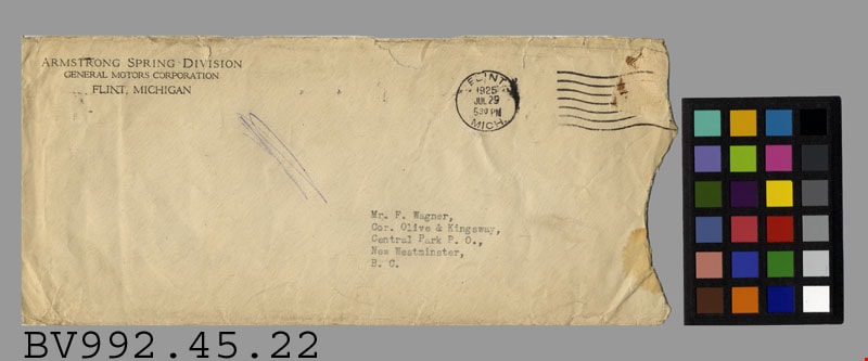
https://search.heritageburnaby.ca/link/museumartifact34773
- Repository
- Burnaby Village Museum
- Accession Code
- BV992.45.22
- Description
- Armstrong Spring Division - Envelope -- [1925]. Envelope, buff paper; preprinted return address in black at upper left, "ARMSTRONG SPRING DIVISION" "GENERAL MOTORS CORPORATION" "FLINT, MICHIGAN"; typewritten address in black "Mr F. Wagner," "Cor. Olive & Kingsway," "Central Park P.O.," "New Westminster," "B.C."; partial brown stamp at upper right, torn off; postmark "FLINT MICH." "1925" "JUL 29" "530 PM" and seven wavy lines; right end torn off; no contents, some tears, stains, and discolouration, scribble in blue ink between sender's and recipients' addresses
- Object History
- Mr. Wagner patented his Triple Spring Bumper for automobiles and attempted to interest one of the major automobile manufacturers in purchasing his patent. He manufactured some bumpers and sold them locally.
- Colour
- Beige
Images

Gilmour Avenue School site
https://search.heritageburnaby.ca/link/museumdescription11129
- Repository
- Burnaby Village Museum
- Date
- May 27, 1915
- Collection/Fonds
- Ronald G. Scobbie collection
- Description Level
- Item
- Physical Description
- 1 survey plan : blueprint on paper ; 56 x 54 cm
- Scope and Content
- Survey plan of Gilmore Avenue School site. Title on plan reads: "Gilmour Avenue School Site / Burnaby Municipality / Being Lots 1-10 inc. & Lots 27-36 inc. of Block 9 / of Subdivision of a Portion of Lot 187, GP.1 / New Westminster District". "Note. School site is as shown below, the original...am…
- Repository
- Burnaby Village Museum
- Collection/Fonds
- Ronald G. Scobbie collection
- Description Level
- Item
- Physical Description
- 1 survey plan : blueprint on paper ; 56 x 54 cm
- Material Details
- Scale: 40 feet = 1 inch
- Scope and Content
- Survey plan of Gilmore Avenue School site. Title on plan reads: "Gilmour Avenue School Site / Burnaby Municipality / Being Lots 1-10 inc. & Lots 27-36 inc. of Block 9 / of Subdivision of a Portion of Lot 187, GP.1 / New Westminster District". "Note. School site is as shown below, the original...amended" "by cancelling Lots 1-10 & 27-30 inc....order of court filed No.4938".
- History
- The school was named after Hugh B. Gilmour, but an error by a municipal clerk in the Street Naming Bylaw in 1912 (Bylaw Number 135) changed the spelling to "Gilmore" Avenue and the school name was spelled "Gilmore" Avenue School hereafter.
- Creator
- McGugan, Donald Johnston
- Subjects
- Buildings - Schools
- Names
- Gilmore Avenue School
- Responsibility
- Burnett & McGugan, Engineers and Surveyors
- Geographic Access
- Gilmore Avenue
- Accession Code
- BV003.83.8
- Access Restriction
- No restrictions
- Reproduction Restriction
- No known restrictions
- Date
- May 27, 1915
- Media Type
- Cartographic Material
- Historic Neighbourhood
- Vancouver Heights (Historic Neighbourhood)
- Planning Study Area
- Willingdon Heights Area
- Scan Resolution
- 440
- Scan Date
- 22-Dec-2020
- Scale
- 100
- Notes
- Transcribed title taken from plan
- Oath in bottom left corner reads: "I, D.J. McGugan...did superintend the survey", "...completed on the 27th day of May 1915" and noterized by Walter Edmonds" "sworn...29th Day of May 1915"; "Burnett and McGugan. B.C. Land Surveyors Etc. New Westminster. B.C."
- Note in black ink on verso of plan reads: "1782"
Zoomable Images


Hamilton Road School site
https://search.heritageburnaby.ca/link/museumdescription11139
- Repository
- Burnaby Village Museum
- Date
- April 27, 1915
- Collection/Fonds
- Ronald G. Scobbie collection
- Description Level
- Item
- Physical Description
- 1 survey plan : blueprint on paper ; 56 x 54 cm
- Scope and Content
- Survey plan of "Hamilton Road School Site / Burnaby Municipality" "Being the westerly 2 acres of Block 2 of the subd. of a portion of Lot 8, Group 1"; "New Westminster District”.
- Repository
- Burnaby Village Museum
- Collection/Fonds
- Ronald G. Scobbie collection
- Description Level
- Item
- Physical Description
- 1 survey plan : blueprint on paper ; 56 x 54 cm
- Material Details
- Scale 40 feet = 1 inch
- Scope and Content
- Survey plan of "Hamilton Road School Site / Burnaby Municipality" "Being the westerly 2 acres of Block 2 of the subd. of a portion of Lot 8, Group 1"; "New Westminster District”.
- Creator
- Burnett, Geoffrey K.
- Subjects
- Buildings - Schools
- Names
- Hamilton Road School
- Responsibility
- Burnett & McGugan, Engineers and Surveyors
- Geographic Access
- Lyndhurst Street
- Accession Code
- BV003.83.18
- Access Restriction
- No restrictions
- Reproduction Restriction
- No known restrictions
- Date
- April 27, 1915
- Media Type
- Cartographic Material
- Historic Neighbourhood
- Burquitlam (Historic Neighbourhood)
- Planning Study Area
- Sperling-Broadway Area
- Scan Resolution
- 440
- Scan Date
- 22-Dec-2020
- Scale
- 100
- Notes
- Title based on contents of plan
- handwritten on back, "1752" and mathematical calculations
- Oath on plan reads: "I, Geoffrey K. Burnett...and did person- ally superintend the survey..." "...completed on the 27th day of April 1915"; signed by Geoffrey K. Burnett, notary illegible, sworn "...27th day of April 1915" "Burnett and McGugan" "B.C. Land Surveyors Etc. New Westminster, B.C."
Images


Inman Avenue School site
https://search.heritageburnaby.ca/link/museumdescription11128
- Repository
- Burnaby Village Museum
- Date
- May 3, 1915
- Collection/Fonds
- Ronald G. Scobbie collection
- Description Level
- Item
- Physical Description
- 1 survey plan : blueprint on paper ; 56 x 54 cm
- Scope and Content
- Survey plan of "Inman Avenue School Site" "Burnaby Municipality" "Being Lots 3 -12 inc. Blk. C. of Subd. of Blks.5" "13-19 inc. & 21-28 inc. of Subd. of Westerly 80 Acres of, and portion of D.L. 34, Group One. New Westminster District".
- Repository
- Burnaby Village Museum
- Collection/Fonds
- Ronald G. Scobbie collection
- Description Level
- Item
- Physical Description
- 1 survey plan : blueprint on paper ; 56 x 54 cm
- Material Details
- Scale: 40 feet = 1 inch
- Scope and Content
- Survey plan of "Inman Avenue School Site" "Burnaby Municipality" "Being Lots 3 -12 inc. Blk. C. of Subd. of Blks.5" "13-19 inc. & 21-28 inc. of Subd. of Westerly 80 Acres of, and portion of D.L. 34, Group One. New Westminster District".
- Creator
- McGugan, Donald Johnston
- Subjects
- Buildings - Schools
- Names
- Inman Avenue School
- Responsibility
- Burnett & McGugan, Engineers and Surveyors
- Geographic Access
- Brandon Street
- Street Address
- 3963 Brandon Street
- Accession Code
- BV003.83.7
- Access Restriction
- No restrictions
- Reproduction Restriction
- No known restrictions
- Date
- May 3, 1915
- Media Type
- Cartographic Material
- Historic Neighbourhood
- Central Park (Historic Neighbourhood)
- Planning Study Area
- Garden Village Area
- Scan Resolution
- 440
- Scan Date
- 22-Dec-2020
- Scale
- 100
- Notes
- Title based on contents of plan
- Oath in bottom left corner reads: "I, D.J. McGugan...did...superintend the survey...", "...completed on the 3rd day of May 1915"; signed "D.J. McGugan", notariz- ed by "Walter Edmonds" "sworn...22nd Day of May 1915"; "Burnett and McGugan. B.C. Land Surveyors. Etc. New Westminster. B.C.";
- handwritten note reads: "Note: Before using this Mon. see plan / of resubdivision of Lots 5 & 6 / of Block 'B' D.L. 34 / June 1945"
- handwritten twice on back, "1776"
Zoomable Images

Map of Burnaby Municipality
https://search.heritageburnaby.ca/link/museumdescription9669
- Repository
- Burnaby Village Museum
- Date
- [1922]
- Collection/Fonds
- Ronald G. Scobbie collection
- Description Level
- Item
- Physical Description
- 1 map : black ink ; 66.5 x 54 cm, on waxed linen sheet 70.5 x 48.5 cm
- Scope and Content
- Item consists of a map of the Burnaby Municipality. The map identifies various land features such as: District Lots with names of property owners and parks, wards, railways, roads and water ways.
- Repository
- Burnaby Village Museum
- Collection/Fonds
- Ronald G. Scobbie collection
- Description Level
- Item
- Physical Description
- 1 map : black ink ; 66.5 x 54 cm, on waxed linen sheet 70.5 x 48.5 cm
- Material Details
- Scale 1:31680
- Scope and Content
- Item consists of a map of the Burnaby Municipality. The map identifies various land features such as: District Lots with names of property owners and parks, wards, railways, roads and water ways.
- Creator
- Hill, Albert James
- Accession Code
- BV003.83.42
- Access Restriction
- No restrictions
- Reproduction Restriction
- No known restrictions
- Date
- [1922]
- Media Type
- Cartographic Material
- Notes
- Transcribed title
- Map is signed by "Albert J. Hill / Civil Engineer / and / Provincial Land Surveyor / New Westminster / B.C."
- Title on map reads: "Map / of / Burnaby Municipality"
- Scale: "40 chs = 1 in."
![Map of proposed provincial exhibition site at Burnaby Lake, [between 1929 and 1931] thumbnail](/media/hpo/_Data/_BVM_Cartographic_Material/2017/2017_0002_0009_005.jpg?width=280)
Map of proposed provincial exhibition site at Burnaby Lake
https://search.heritageburnaby.ca/link/museumdescription8703
- Repository
- Burnaby Village Museum
- Date
- [between 1929 and 1931]
- Collection/Fonds
- Burnaby Village Museum Map collection
- Description Level
- Item
- Physical Description
- 1 map : photostat print ; 3 parts 45 x 33.7 cm totalling 45 x 101 cm
- Scope and Content
- Item consists of a tri-part folding map of a proposed Provincial Exhibition site located along the southern and western shore of Burnaby Lake. Exhibtion site on map identifies proposed locations for a golf course, pier, hydroplane landing ramp, sports ground, one-mile horse racing track and various…
- Repository
- Burnaby Village Museum
- Collection/Fonds
- Burnaby Village Museum Map collection
- Description Level
- Item
- Physical Description
- 1 map : photostat print ; 3 parts 45 x 33.7 cm totalling 45 x 101 cm
- Material Details
- Scale [1:1800]
- Scope and Content
- Item consists of a tri-part folding map of a proposed Provincial Exhibition site located along the southern and western shore of Burnaby Lake. Exhibtion site on map identifies proposed locations for a golf course, pier, hydroplane landing ramp, sports ground, one-mile horse racing track and various buildings for mechanical, agricultural and botanical displays.
- Subjects
- Exhibitions
- Accession Code
- BV017.2.9
- Access Restriction
- No restrictions
- Reproduction Restriction
- No known restrictions
- Date
- [between 1929 and 1931]
- Media Type
- Cartographic Material
- Historic Neighbourhood
- Burnaby Lake (Historic Neighbourhood)
- Planning Study Area
- Burnaby Lake Area
- Scan Resolution
- 400
- Scan Date
- 2021-11-18
- Notes
- Title based on contents of map
- Scale on map reads: "150 feet to 1 inch"
- Overall measurements when fully opened: L: 98.0 cm x H: 45.3 cm ; Individual map parts: L: 32.7 cm x H: 45.0 cm
- Commercially printed label on front of portfolio card reads "PLOWRIGHT PRINTING COMPANY / TELEPHONE N.W. 1942 / 39 McKENZIE STREET NEW WESTMINSTER, B.C. / TO: [illegible writing in pencil]" in blue ink. Red typewritten text reads: "PHOTOSTAT OF BURNABY LAKE".
Images
![Map of proposed provincial exhibition site at Burnaby Lake, [between 1929 and 1931] thumbnail](/media/hpo/_Data/_BVM_Cartographic_Material/2017/2017_0002_0009_005.jpg)


Nelson Avenue School site
https://search.heritageburnaby.ca/link/museumdescription11135
- Repository
- Burnaby Village Museum
- Date
- April 12, 1915
- Collection/Fonds
- Ronald G. Scobbie collection
- Description Level
- Item
- Physical Description
- 1 survey plan : blueprint on paper ; 56 x 54 cm
- Scope and Content
- Survey plan of "Nelson Avenue School Site / Burnaby Municipality" "Being the south half of Block 19, except therefrom the north 33 feet, of Lot 99, Gp. 1. New Westminster District".
- Repository
- Burnaby Village Museum
- Collection/Fonds
- Ronald G. Scobbie collection
- Description Level
- Item
- Physical Description
- 1 survey plan : blueprint on paper ; 56 x 54 cm
- Material Details
- Scale 40 feet = 1 inch
- Scope and Content
- Survey plan of "Nelson Avenue School Site / Burnaby Municipality" "Being the south half of Block 19, except therefrom the north 33 feet, of Lot 99, Gp. 1. New Westminster District".
- Creator
- McGugan, Donald Johnston
- Subjects
- Buildings - Schools
- Names
- Nelson Avenue School
- Responsibility
- Burnett & McGugan, Engineers and Surveyors
- Geographic Access
- Irmin Street
- Street Address
- 4850 Irmin Street
- Accession Code
- BV003.83.14
- Access Restriction
- No restrictions
- Reproduction Restriction
- No known restrictions
- Date
- April 12, 1915
- Media Type
- Cartographic Material
- Historic Neighbourhood
- Alta Vista (Historic Neighbourhood)
- Planning Study Area
- Sussex-Nelson Area
- Scan Resolution
- 440
- Scan Date
- 22-Dec-2020
- Scale
- 100
- Notes
- Title based on contents of plan
- Note in black ink on verso of plan reads: "1745"
- Oath on plan reads: "I, D.G. McGugan..." "...and did person- ally superintend the survey..." "...completed on the 5th day of March 1915"; signed by D.J. McGugan, notarized by "R.E. Chapman", sworn "...12th day of April 1915" "Burnett and McGugan" "B.C. Land Surveyors Etc. New Westminster, B.C.."
Images


Plan of Subdivision of Lot 14 of North part of NW 1/4 of D.L. 150 GR.1 N.W.D
https://search.heritageburnaby.ca/link/museumdescription11117
- Repository
- Burnaby Village Museum
- Date
- 1912
- Collection/Fonds
- Ronald G. Scobbie collection
- Description Level
- Item
- Physical Description
- 2 plans : ink on linen + blueprint ; 21.5 x 27.5 cm
- Scope and Content
- File consists of "Plan of Subdivision of Lot 14 of North / Part of N.W. 1/4 of D.L. 150, GR.1. / N.W.D." and blueprint of same.
- Repository
- Burnaby Village Museum
- Collection/Fonds
- Ronald G. Scobbie collection
- Description Level
- Item
- Physical Description
- 2 plans : ink on linen + blueprint ; 21.5 x 27.5 cm
- Material Details
- Scale [1:1200]
- Scope and Content
- File consists of "Plan of Subdivision of Lot 14 of North / Part of N.W. 1/4 of D.L. 150, GR.1. / N.W.D." and blueprint of same.
- Creator
- Hill & Burnett
- Geographic Access
- Jubilee Avenue
- Accession Code
- HV984.57.10
- Access Restriction
- No restrictions
- Reproduction Restriction
- No known restrictions
- Date
- 1912
- Media Type
- Cartographic Material
- Planning Study Area
- Suncrest Area
- Scan Resolution
- 600
- Scan Date
- 2-Oct-19
- Scale
- 100
- Notes
- Transcribed title
- Notes in red crayon on verso of both plans read: "00079"
- Oval shaped stamp in blue ink on front of blueprint plan reads: "Corporation of Burnaby / Feb. 2 1912 / Engineering Department"
- Stamp in red ink on verso of Blueprint plan reads: "Hill & Burnett / Civil Engineers / B.C. Land Surveyors / New Westminster B.C."
- Handwritten note on front of blueprint plan reads: "T... [sic] approved / subject to 20' Laws [sic] / being given. / Fred L. Macpherson / Engineer / Feb. 6th 1912"
Images


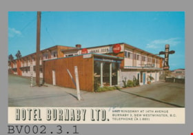
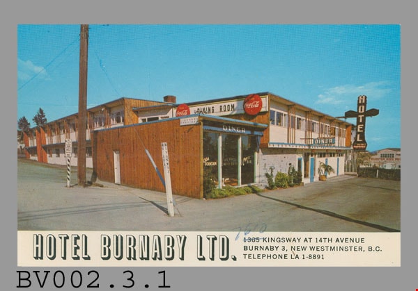
postcard
https://search.heritageburnaby.ca/link/museumartifact44127
- Repository
- Burnaby Village Museum
- Accession Code
- BV002.3.1
- Description
- Postcard: colour photo, glossy; horizontal; hotel; white bar across bottom with black-shaded white "HOTEL BURNABY LTD.", black "1385 KINGSWAY AT 14th AVENUE" "BURNABY 3, NEW WESTMINSTER, B.C." "TELEPHONE LA 1-8891"; '1385' crossed out, '7610' written above in pen; shows two-storey building with wood trim, white plaster; totem-pole shaped neon sign, vertical "HOTEL" on black ground, "VACANCY" and "PARKING" below; "DINER" on blue awning of nearest part of building, single-storey; black "DINING ROOM" on white sign on side of higher building, red "Coca-Cola" bottlecap sign either side; New Westminster Hog Fuel? building visible in background; on reverse in blue, "HOTEL BURNABY" "Located between new Simpson-Sears and new Woodwards shopping centres. You will remember HOTEL BURNABY for the REST of your life."; up centre, "MADE IN CANADA BY GRANT-MANN LITHOGRAPHERS LTD. "COLOR CARD" DIVISION, VANCOUVER, BRITISH COLUMBIA."; at bottom, "C-50"; at top, "POST CARD" "ADDRESS"; outline of rectangle at upper right, "STAMP"; c. late 1950s; unused; pencilled "1-" at top; lightly soiled; corners worn
- Classification
- Written Communication T&E - - Writing Media
- Object Term
- Postcard
- Country Made
- Canada
- Province Made
- British Columbia
- Site/City Made
- Vancouver
- Title
- Hotel Burnaby Ltd. C-50
- Subjects
- Souvenirs
Images
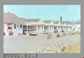
postcard
https://search.heritageburnaby.ca/link/museumartifact45030
- Repository
- Burnaby Village Museum
- Accession Code
- BV002.61.3
- Description
- Postcard: colour photo, glossy; horizontal; row of single-storey white bungalows with red trim, cars, people sitting in folding chairs, driveway, stone wall and coloured flower planters mounted on wall with metal supports; on reverse in blue "Open all Year" "De VALL'S AUTO VILLAS & MOTEL" "4361, Kingsway, S.B.1" "VANCOUVER, B.C., CANADA" "Phone HE-3-0033" and promotional copy; at bottom left, "Photo Stamp Distributors, 809 21st. St. New Westminster, B.C."; up centre is "Published by Alex Wilson Publications Ltd., Dryden, Ontario"; at bottom, "Spectrome COLOR" "WILSON DRYDEN ONT." "MADE IN CANADA", lion logo, 'Spectrome' has 'R' in circle beside it; at upper right, "POST CARD" "ADDRESS ONLY", outline of rectangle with "This Card is a 100% Canadian Product"; at bottom right, "3421R"; pencilled at top centre, "2-"; slight peeling of upper left corner; unused
- Classification
- Written Communication T&E - - Writing Media
- Object Term
- Postcard
- Country Made
- Canada
- Province Made
- Ontario
- Site/City Made
- Dryden
- Title
- De Vall's Auto Villas & Motel 3421R
- Subjects
- Documentary Artifacts
- Documentary Artifacts - Postcards
- Documentary Artifacts - Photographs
- Buildings
- Buildings - Commercial
- Buildings - Commercial - Hotels and Motels
Images
