Narrow Results By
Creator
- Blackmore, R. D., (Richard Doddridge), 1825-1900 1
- Black, Newton Henry, 1874-1961 1
- Brown, William Thomas 1
- Burnett, Geoffrey K. 3
- Burnett & McGugan, Engineers and Surveyors 10
- Clark, R.H. 1
- Conant, James Bryant, 1893-1978 1
- Dobbie, W.J. 1
- Fraser, W. H. (William Henry), 1853-1916 1
- French, Charles Wallace, 1858-1920 1
- Gammell, I. (Isaac), 1861-1932 1
- Gernsback, Hugo, 1884-1967 2

Armstrong Street School site
https://search.heritageburnaby.ca/link/museumdescription11133
- Repository
- Burnaby Village Museum
- Date
- 1915
- Collection/Fonds
- Ronald G. Scobbie collection
- Description Level
- Item
- Physical Description
- 1 survey plan : blueprint on paper ; 56 x 54 cm
- Scope and Content
- Survey plan of "Armstrong Street School Site / Burnaby Municipality" "Being a 2 acre portion of Lot 13 Group 1, & according to map 1722 which shows this as Lot E. Block 2 of subdivision of a portion, of Lot 13, Group 1, New Westminster District".
- Repository
- Burnaby Village Museum
- Collection/Fonds
- Ronald G. Scobbie collection
- Description Level
- Item
- Physical Description
- 1 survey plan : blueprint on paper ; 56 x 54 cm
- Material Details
- Scale 40 feet = 1 inch
- Scope and Content
- Survey plan of "Armstrong Street School Site / Burnaby Municipality" "Being a 2 acre portion of Lot 13 Group 1, & according to map 1722 which shows this as Lot E. Block 2 of subdivision of a portion, of Lot 13, Group 1, New Westminster District".
- Creator
- Burnett, Geoffrey K.
- Subjects
- Buildings - Schools
- Names
- Armstrong Avenue School
- Responsibility
- Burnett & McGugan, Engineers and Surveyors
- Geographic Access
- Armstrong Avenue
- Street Address
- 8757 Armstrong Avenue
- Accession Code
- BV003.83.12
- Access Restriction
- No restrictions
- Reproduction Restriction
- No known restrictions
- Date
- 1915
- Media Type
- Cartographic Material
- Historic Neighbourhood
- East Burnaby (Historic Neighbourhood)
- Planning Study Area
- Cariboo-Armstrong Area
- Scan Resolution
- 440
- Scan Date
- 22-Dec-2020
- Scale
- 100
- Notes
- Title based on contents of plan
- Note in black ink on verso of plan reads: "1746"
- Oath on plan reads: "I, Geoffrey K. Burnett...and did personally superintend the survey represented..." "Completed on the 18th day of March 1915"; signed by Geoffrey K. Burnett and notarized by "K.A. Eastman", sworn "...19th day of April 1915"; "Burnett and McGugan., B.C. Land Surveyors. Etc.. New Westminster, B.C.."
Zoomable Images


Barnet School site
https://search.heritageburnaby.ca/link/museumdescription11140
- Repository
- Burnaby Village Museum
- Date
- May 27, 1915
- Collection/Fonds
- Ronald G. Scobbie collection
- Description Level
- Item
- Physical Description
- 1 survey plan : blueprint on paper ; 56 x 54 cm
- Scope and Content
- Survey plan of "Barnet School Site / Burnaby Municipality" "Being a portion of the west half of lot / 214, Group 1 / New Westminster District”.
- Repository
- Burnaby Village Museum
- Collection/Fonds
- Ronald G. Scobbie collection
- Description Level
- Item
- Physical Description
- 1 survey plan : blueprint on paper ; 56 x 54 cm
- Material Details
- Scale 40 feet = 1 inch
- Scope and Content
- Survey plan of "Barnet School Site / Burnaby Municipality" "Being a portion of the west half of lot / 214, Group 1 / New Westminster District”.
- Creator
- McGugan, Donald Johnston
- Subjects
- Buildings - Schools
- Names
- Barnet School
- Responsibility
- Burnett & McGugan, Engineers and Surveyors
- Geographic Access
- Barnet Road
- Street Address
- 7820 Barnet Road
- Accession Code
- BV003.83.19
- Access Restriction
- No restrictions
- Reproduction Restriction
- No known restrictions
- Date
- May 27, 1915
- Media Type
- Cartographic Material
- Historic Neighbourhood
- Barnet (Historic Neighbourhood)
- Planning Study Area
- Burnaby Mountain Area
- Scan Resolution
- 440
- Scan Date
- 22-Dec-2020
- Scale
- 100
- Notes
- Title based on contents of plan
- handwritten on back "Burnaby Schools" "23R" twice, "1783"
- Oath on plan reads: "I, D.J. McGugan...and did personally superintend the survey..." "completed on the 27th day of May 1915"; signed by D.J. McGugan, notarized by "Walter Edmonds" "sworn "...29th day of May 1915" "Burnett and McGugan" "B.C. Land Surveyors Etc. New Westminster, B.C.";
Zoomable Images

Beautiful Burnaby, British Columbia
https://search.heritageburnaby.ca/link/museumlibrary1108
- Repository
- Burnaby Village Museum
- Collection
- Reference Collection
- Material Type
- Textual Record
- Call Number
- 971.1 BEA
- Place of Publication
- New Westminster, B.C.
- Publisher
- Jackson Printing Co.
- Publication Date
- 1921
- 1927
- Physical Description
- 40 p. : ill. ; 30 cm.
- Library Subject (LOC)
- Burnaby (B.C.)--History
- Burnaby (B.C.)--Description and travel
Brackman-Ker Milling Co. Jubilee Picnic at Bowen Island
https://search.heritageburnaby.ca/link/museumdescription2958
- Repository
- Burnaby Village Museum
- Date
- August 11, 1928
- Collection/Fonds
- Burnaby Village Museum Photograph collection
- Description Level
- Item
- Physical Description
- 1 photograph : sepia ; panorama 53 x 20.2 cm
- Scope and Content
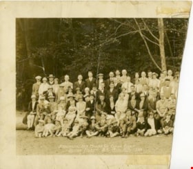
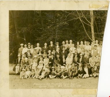
- Photograph is a panorama of the "BRACKMAN-KER MILLING CO. JUBILE(sic) PICNIC / BOWEN ISLAND, B.C. AUG.11th, 1928". The photograph presumably shows the employees and families of the Brackman-Ker Milling Co. The adults are mostly posed standing in four rows. There are some children being held in…
- Repository
- Burnaby Village Museum
- Collection/Fonds
- Burnaby Village Museum Photograph collection
- Description Level
- Item
- Physical Description
- 1 photograph : sepia ; panorama 53 x 20.2 cm
- Scope and Content
- Photograph is a panorama of the "BRACKMAN-KER MILLING CO. JUBILE(sic) PICNIC / BOWEN ISLAND, B.C. AUG.11th, 1928". The photograph presumably shows the employees and families of the Brackman-Ker Milling Co. The adults are mostly posed standing in four rows. There are some children being held in the arms of adults, but most of the children in the photograph are seated on the ground along the front of the group. There is also a dog lying down on the ground to the right side of the group. The group is posed in a grassy area, with trees and the roof of a square building visible in the background.
- Subjects
- Celebrations - Jubilee
- Accession Code
- HV971.1.35
- Access Restriction
- No restrictions
- Reproduction Restriction
- No known restrictions
- Date
- August 11, 1928
- Media Type
- Photograph
- Scan Resolution
- 600
- Scan Date
- 2023-03-23
- Photographer
- Stride, Charles Edgar
- Notes
- Title based on contents of photograph
- Title on front of photograph read: "BRACKMAN-KER MILLING CO. JUBILE(sic) PICNIC / BOWEN ISLAND, B.C. AUG.11th, 1928" and "PHOTO BY THE STRIDE STUDIOS / NEW WESTMINSTER, B.C."
Images
![Burnaby May Queen, [between 1926 and 1939] thumbnail](/media/hpo/_Data/_BVM_Images/1974/197400290001.jpg?width=280)
Burnaby May Queen
https://search.heritageburnaby.ca/link/museumdescription917
- Repository
- Burnaby Village Museum
- Date
- [between 1926 and 1939]
- Collection/Fonds
- Burnaby Village Museum Photograph collection
- Description Level
- Item
- Physical Description
- 1 photograph : b&w ; 23 x 18 cm (sight), mounted in folder 87 x 25.5 cm folded to 34 x 25.5 cm
- Scope and Content
- Photograph of a Burnaby May Queen sitting in profile with a bouquet of tulips at her side. She is wearing a diamond necklace and a 'crown of flowers' in her hair.
- Repository
- Burnaby Village Museum
- Collection/Fonds
- Burnaby Village Museum Photograph collection
- Description Level
- Item
- Physical Description
- 1 photograph : b&w ; 23 x 18 cm (sight), mounted in folder 87 x 25.5 cm folded to 34 x 25.5 cm
- Scope and Content
- Photograph of a Burnaby May Queen sitting in profile with a bouquet of tulips at her side. She is wearing a diamond necklace and a 'crown of flowers' in her hair.
- Subjects
- Events - May Day
- Accession Code
- HV974.29.1
- Access Restriction
- No restrictions
- Date
- [between 1926 and 1939]
- Media Type
- Photograph
- Scan Resolution
- 600
- Scan Date
- 1/11/2010
- Scale
- 100
- Photographer
- Stride, Charles Edgar
- Notes
- Title based on contents of photograph
- Window mat (at interior of folder) has decorative embossing
- Window mat and folder backing (provided by photographic studio) are glued together
- Photographer's mark on recto of card mount reads: "The Stride Studios, New Westminster, B.C."
Images
![Burnaby May Queen, [between 1926 and 1939] thumbnail](/media/hpo/_Data/_BVM_Images/1974/197400290001.jpg)
Certificate of encumbrance
https://search.heritageburnaby.ca/link/museumdescription10070
- Repository
- Burnaby Village Museum
- Date
- 1925
- Collection/Fonds
- Love family fonds
- Description Level
- Item
- Physical Description
- 1 p. of textual records
- Scope and Content
- Item consists of CERTIFICATE OF ENCUMBRANCE / #25320 Land Registry Office / New Westminster, B.C. / 30 minutes past 10 o'clock 10th day of March 1925" regarding the title to"Lot 56 of Lot 7, Suburban Block 1, Map 2620 in the City of New Westminster" with the "Registered Owner : Jesse Love" to mortg…
- Repository
- Burnaby Village Museum
- Collection/Fonds
- Love family fonds
- Description Level
- Item
- Physical Description
- 1 p. of textual records
- Scope and Content
- Item consists of CERTIFICATE OF ENCUMBRANCE / #25320 Land Registry Office / New Westminster, B.C. / 30 minutes past 10 o'clock 10th day of March 1925" regarding the title to"Lot 56 of Lot 7, Suburban Block 1, Map 2620 in the City of New Westminster" with the "Registered Owner : Jesse Love" to mortgage said property to John Whiting.
- History
- See extensive history of Love Family and Love farmhouse located at Burnaby Village Museum.
- Accession Code
- BV012.31.2
- Access Restriction
- No restrictions
- Reproduction Restriction
- No known restrictions
- Date
- 1925
- Media Type
- Textual Record
- Notes
- Title based on content of file
Deed of Land between George R. Love and Jesse Love re Lot 56 of Lot 7, subdivision of Block 12
https://search.heritageburnaby.ca/link/museumdescription18785
- Repository
- Burnaby Village Museum
- Date
- 16 Sep. 1911
- Collection/Fonds
- Love family fonds
- Description Level
- Item
- Physical Description
- 1 p. of textual records
- Scope and Content
- Item consists of Deed of Land dated September 16, 1911 between George R. Love and Jesse Love for Lot fifty-six (56) of Lot seven (7), Subdivision of Block twelve (12).
- Repository
- Burnaby Village Museum
- Collection/Fonds
- Love family fonds
- Description Level
- Item
- Physical Description
- 1 p. of textual records
- Material Details
- watermark "BERKSHIRE BOND"
- Scope and Content
- Item consists of Deed of Land dated September 16, 1911 between George R. Love and Jesse Love for Lot fifty-six (56) of Lot seven (7), Subdivision of Block twelve (12).
- Accession Code
- BV992.26.5
- Access Restriction
- No restrictions
- Reproduction Restriction
- No known restrictions
- Date
- 16 Sep. 1911
- Media Type
- Textual Record
- Notes
- Title based on contents of item
- document dated Sept. 16th 1911; "George R. Love" "East Burnaby, B.C." "TO" "Jessie Love" "East Burnaby, B.C."; "Deed of Land" "SITUATE IN" "City of New Westminster, B.C."; stamped in red with land registry office stamp, "NOT EXAMINED" "SEP 25 1911" "...DUPLICATE..." "32261"; printed below, "F.J. HART & CO., LTD." "REAL ESTATE, NOTARIES PUBLIC" "CONVEYANCERS" NEW WESTMINSTER, VANCOUVER AND CHILLIWACK, B.C."; at bottom, "JACKSON PRINTING COMPANY, NEW WESTMINSTER"; buff paper, folds out to legal size; pink, blue and white borders; black print, blue typewriting (carbon); "This Indenture", for $1000, for parcel of land Lot 56 of Lot 7, subdivision of Bl.12, suburban, New Westminster, B.C.; subject to indenture of mortgage between George R. Love and The British Columbia Permanent Loan Company, and to agreement for sale with Mr. and Mrs. Morrison; signed by George R. Love, small red seal; witnessed by H.A. Eastman; "FOR MAKER" signed by H.A. Eastman, Sept. 27, 1911; stamp seal "HENRY ALFRED EASTMAN" "BRITISH COLUMBIA" "NOTARY PUBLIC".
Deed of Land between Henry A. Eastman and George R. Love re Lots 55 and 56 of Lot 7 and 12
https://search.heritageburnaby.ca/link/museumdescription18786
- Repository
- Burnaby Village Museum
- Date
- 7 Apr. 1911
- Collection/Fonds
- Love family fonds
- Description Level
- Item
- Physical Description
- 1 p. of textual records
- Scope and Content
- Item consists of Deed of Land dated April 7, 1911 between Henry Alfred Eastman and George R. Love of East Burnaby for Lots fifty-five (55) and fifty-six (56) of Lot seven (7), Block twelve (12) Suburban.
- Repository
- Burnaby Village Museum
- Collection/Fonds
- Love family fonds
- Description Level
- Item
- Physical Description
- 1 p. of textual records
- Material Details
- watermark "BERKSHIRE BOND"
- Scope and Content
- Item consists of Deed of Land dated April 7, 1911 between Henry Alfred Eastman and George R. Love of East Burnaby for Lots fifty-five (55) and fifty-six (56) of Lot seven (7), Block twelve (12) Suburban.
- Accession Code
- BV992.26.6
- Access Restriction
- No restrictions
- Reproduction Restriction
- No known restrictions
- Date
- 7 Apr. 1911
- Media Type
- Textual Record
- Notes
- Title based on contents of item
- document, buff paper, legal-sized; dated April 7th, 1911; "HENRY A. EASTMAN" of New Westminster, B.C. to "GEORGE R. LOVE" of East Burnaby, B.C.; "This Indenture", for the payment of $1400, is for parcels or tracts of land in New Westminster, Lots 55 and 56 of Lot 7, Block 12 Suburban; typing is purple, carbon?; signed by H.A. Eastman, witnessed by R.K. Chapman; red seal and impressed seal "ROBERT KEAM CHAPMAN" "BRITISH COLUMBIA" "NOTARY PUBLIC"; when folded, outside panel has "Deed of Land SITUATE IN City of New Westminster, B.C."; stamped in red "LAND REGISTRY OFFICE" "NEW WESTMINSTER, B.C." "NOT EXAMINED" "APR 8- 1911" "THIS PURPORTS TO BE A DUPLICATE ONLY, ORIGINAL DEPOSITED WITH APPLICATION NO.", black stamp; "28041"; at bottom, "F.J. HART & CO., LTD." "REAL ESTATE, NOTARIES PUBLIC", "CONVEYANCERS", "NEW WESTMINSTER, VANCOUVER AND CHILLIWACK, B.C."; Jackson Printing Company, New Westminster;
Deed of Land between L. Claude Hill and Frank Smith and William Reid re Subdivision 8 of Lot 5 Block 13
https://search.heritageburnaby.ca/link/museumdescription18784
- Repository
- Burnaby Village Museum
- Date
- 13 Mar. 1911
- Collection/Fonds
- Love family fonds
- Description Level
- Item
- Physical Description
- 1 p. of textual records
- Scope and Content
- Item consists of Item consists of a Deed of Land between L. Claude Hill and Frank P. Smith and William T. Reidl for Subdivision eight (8) of South Half of Lot five (5), Suburban Block Thirteen (XIII).
- Repository
- Burnaby Village Museum
- Collection/Fonds
- Love family fonds
- Description Level
- Item
- Physical Description
- 1 p. of textual records
- Scope and Content
- Item consists of Item consists of a Deed of Land between L. Claude Hill and Frank P. Smith and William T. Reidl for Subdivision eight (8) of South Half of Lot five (5), Suburban Block Thirteen (XIII).
- Accession Code
- BV992.26.4
- Access Restriction
- No restrictions
- Reproduction Restriction
- No known restrictions
- Date
- 13 Mar. 1911
- Media Type
- Textual Record
- Notes
- Title based on contents of item
- document, dated March 13th 1911; "L. CLAUDE HILL" "TO" "FRANK P. SMITH AND WILLIAM T. REID."; "Deed of Land" "SITUATE IN" "Subd. 8. Lot Five Sub. Blk. XIII."; "27361"; overstamped in red with "LAND REGISTRY OFFICE" stamp, "NOT EXAMINED" "...DUPLICATE ONLY..."; printed below inside decorative border, "REAL ESTATE" "PHONE 169" "J.J. JOHNSTON" "COLUMBIA ST NEW WESTMINSTER, B.C." "INSURANCE"; printed below border is "JACKSON PRINTING COMPANY, NEW WESTMINSTER"
- buff paper, folds out to legal-sized; black print, pink, white and blue borders; "This Indenture", all parties from New Westminster; for $350, for parcel named; signed by L. Claude Hill, small red seal; witnessed by Clayton A. Bourne; "FOR WITNESS" section signed March 16, 1911, by J.J. Johnston, Commissioner for taking Affidavits in B.C.;
Deed of Land between Smith, Reid and Lindahl re Subdivision 8 of Lot 5 Block 13
https://search.heritageburnaby.ca/link/museumdescription18782
- Repository
- Burnaby Village Museum
- Date
- 13 Mar. 1911
- Collection/Fonds
- Love family fonds
- Description Level
- Item
- Physical Description
- 1 p. of textual records
- Scope and Content
- Item consists of a Deed of Land between Frank P. Smith and William T. Reid and Henrick Lindahl for Subdivision eight (8) of South Half of Lot five (5), Suburban Block Thirteen (XIII).
- Repository
- Burnaby Village Museum
- Collection/Fonds
- Love family fonds
- Description Level
- Item
- Physical Description
- 1 p. of textual records
- Scope and Content
- Item consists of a Deed of Land between Frank P. Smith and William T. Reid and Henrick Lindahl for Subdivision eight (8) of South Half of Lot five (5), Suburban Block Thirteen (XIII).
- Accession Code
- BV992.26.2
- Access Restriction
- No restrictions
- Reproduction Restriction
- No known restrictions
- Date
- 13 Mar. 1911
- Media Type
- Textual Record
- Notes
- Title based on contents of item
- "FRANK P. SMITH AND WILLIAM T. REID" "TO" "HENRIK LINDAHL", "Deed of Land" "SITUATE IN" "Subd. 8 Lot Five. Sub. Blk. XIII"; below, printed in decorative border, "REAL ESTATE" "PHONE 169" "J.J. JOHNSTON" "COLUMBIA ST. NEW WESTMINSTER, B.C." "INSURANCE"; overstamped in red with land registry office stamp, "NOT EXAMINED" "MAR 17 1911" "THIS PURPORTS TO BE A DUPLICATE... 27362"; below border, "JACKSON PRINTING COMPANY, NEW WESTMINSTER"; buff paper, legal-sized, black print, pink, white and blue borders; opens out to "This Indenture", between Smith and Reid of New Westminster and Lindahl of New Westminster; for $350 for said parcel; typed, purple carbon paper; signed by Smith and Reid, small red seals; witnessed by Clayton A. Bourne; "FOR WITNESS" signed by J.J.Johnston, Commissioner for taking Affidavits in B.C.
The Dominion high school arithmetic
https://search.heritageburnaby.ca/link/museumlibrary5081
- Repository
- Burnaby Village Museum
- Collection
- Special Collection
- Material Type
- Book
- Accession Code
- X3253
- Call Number
- 513 DOM
- Place of Publication
- Toronto
- Publisher
- W. J. Gage & Company, Limited
- Publication Date
- 1921
- Physical Description
- viii, 9-339 p. ; 19 cm.
- Inscription
- "Harold Yallop, Div. 10," [handwritten in dark ink on t.p. verso] "H. Morey & Co. Booksellers & Stationers 891 Columbia St New Westminster, B.C. [stamped in faded dark ink on back endpaper]
- Library Subject (LOC)
- Arithmetic--Textbooks
- Mathematics--Textbooks
- Mathematics--Historical texts
- Notes
- "Authorized for use in the schools of Manitoba and British Columbia" --t.p.
The Dominion high school arithmetic
https://search.heritageburnaby.ca/link/museumlibrary5902
- Repository
- Burnaby Village Museum
- Collection
- Special Collection
- Material Type
- Book
- Accession Code
- BV001.1.16
- Call Number
- 513 WJG
- Place of Publication
- Toronto
- Publisher
- W. J. Gage & Co.
- Publication Date
- 1923
- c1925
- Physical Description
- viii, 339 p. : ill. ; 19 cm.
- Inscription
- inside front cover: "Eric Coe" [handwritten in pencil] "2684 Fern Ave" "Jubilee" "Burnaby" "Iver Gillen loves guess?" [handwritten in pencil] "Night School, Mar,18, 1925" with notes throughout [handwritten in pencil] inside back cover: "Nixon's Book Store [ink stamp] "New Westminster, B.C." "R.R.H." [handwritten in pencil]
- Library Subject (LOC)
- Arithmetic--Study and teaching
- Arithmetic--Textbooks
- Mathematics--Textbooks
- Mathematics--Historical texts
- Names
- Coe, Eric
- Notes
- "Authorized for use in the schools of Manitoba, British Columbia, and Nova Scotia"

Douglas Road School site
https://search.heritageburnaby.ca/link/museumdescription11136
- Repository
- Burnaby Village Museum
- Date
- April 19, 1915
- Collection/Fonds
- Ronald G. Scobbie collection
- Description Level
- Item
- Physical Description
- 1 survey plan : blueprint on paper ; 56 x 54 cm
- Scope and Content
- Survey plan of "Douglas Road School Site / Burnaby Municipality" "Being Lot 21, of Blocks 1-5 inc. 11 & 12 of the subd. of north half of Lot 80, Group 1, New Westminster District".
- Repository
- Burnaby Village Museum
- Collection/Fonds
- Ronald G. Scobbie collection
- Description Level
- Item
- Physical Description
- 1 survey plan : blueprint on paper ; 56 x 54 cm
- Material Details
- Scale 40 feet = 1 inch
- Scope and Content
- Survey plan of "Douglas Road School Site / Burnaby Municipality" "Being Lot 21, of Blocks 1-5 inc. 11 & 12 of the subd. of north half of Lot 80, Group 1, New Westminster District".
- Creator
- McGugan, Donald Johnston
- Subjects
- Buildings - Schools
- Names
- Douglas Road School
- Responsibility
- Burnett & McGugan, Engineers and Surveyors
- Geographic Access
- Canada Way
- Street Address
- 4861 Canada Way
- Accession Code
- BV003.83.15
- Access Restriction
- No restrictions
- Reproduction Restriction
- No known restrictions
- Date
- April 19, 1915
- Media Type
- Cartographic Material
- Historic Neighbourhood
- Burnaby Lake (Historic Neighbourhood)
- Planning Study Area
- Douglas-Gilpin Area
- Scan Resolution
- 440
- Scan Date
- 22-Dec-2020
- Scale
- 100
- Notes
- Title based on contents of plan
- Note in black ink on verso of plan reads: "1747"
- Oath on plan reads: "I, D.G. McGugan..." "...and did person- ally superintend the survey..." "...completed on the 3rd day of April 1915"; signed by D.J. McGugan, notarized by "H.A. Eastman", sworn "...19th day of April 1915" "Burnett and McGugan" "B.C. Land Surveyors Etc. New Westminster, B.C.."
Images

![The Drive Queen's Park, New Westminster, B.C., [1913], sent by mail June 23, 1913 thumbnail](/media/hpo/_Data/_Archives_Images/_Unrestricted/001/001-030.jpg?width=280)
The Drive Queen's Park, New Westminster, B.C.
https://search.heritageburnaby.ca/link/archivedescription57740
- Repository
- City of Burnaby Archives
- Date
- [1913], sent by mail June 23, 1913
- Collection/Fonds
- Burnaby Historical Society fonds
- Description Level
- Item
- Physical Description
- 1 photograph : b&w postcard ; 16 x 11 cm mounted on card 9 x 14 cm
- Scope and Content
- Photographic postcard of a roadway entitled "the Drive Queen's Park in New Westminster".
- Repository
- City of Burnaby Archives
- Date
- [1913], sent by mail June 23, 1913
- Collection/Fonds
- Burnaby Historical Society fonds
- Subseries
- Stride family subseries
- Physical Description
- 1 photograph : b&w postcard ; 16 x 11 cm mounted on card 9 x 14 cm
- Description Level
- Item
- Record No.
- 001-030
- Access Restriction
- No restrictions
- Reproduction Restriction
- No known restrictions
- Accession Number
- BHS2007-04
- Scope and Content
- Photographic postcard of a roadway entitled "the Drive Queen's Park in New Westminster".
- Subjects
- Geographic Features - Roads
- Media Type
- Photograph
- Notes
- Handwritten note on verso of postcard reads: "Dear Friend, / We are having splendid weather here at present. Please write if you get this card so i will know if it reaches you. / Grace / Thanks for the lovely card that you sent."
- Photographer identified by surname "Brown" only
Images
![The Drive Queen's Park, New Westminster, B.C., [1913], sent by mail June 23, 1913 thumbnail](/media/hpo/_Data/_Archives_Images/_Unrestricted/001/001-030.jpg)
![Dugald Campbell Patterson, Sr, [between 1910 and 1914] (date of original), copied 1977 thumbnail](/media/hpo/_Data/_BVM_Images/1977/1977_0099_0006_001.jpg?width=280)
Dugald Campbell Patterson, Sr
https://search.heritageburnaby.ca/link/museumdescription564
- Repository
- Burnaby Village Museum
- Date
- [between 1910 and 1914] (date of original), copied 1977
- Collection/Fonds
- Burnaby Village Museum Photograph collection
- Description Level
- Item
- Physical Description
- 1 photograph : b&w ; 20.32 x 25.4 cm print
- Scope and Content
- Photograph portrait of Dugald Campbell Patterson, Sr.
- Repository
- Burnaby Village Museum
- Collection/Fonds
- Burnaby Village Museum Photograph collection
- Description Level
- Item
- Physical Description
- 1 photograph : b&w ; 20.32 x 25.4 cm print
- Scope and Content
- Photograph portrait of Dugald Campbell Patterson, Sr.
- History
- Dugald Campbell Patterson Sr. arrived in Burnaby in 1894. He worked for Armstrong Morrison & Balfour and later became foreman boilermaker for the Vancouver Engineering Works. He was the first postmaster of Edmonds in 1909, and was elected a school trustee in 1912. He was a Director of the British Columbia Electric and Water Heat Company and was a member of the New Westminster Board of Trade. He founded an insurance and real estate company in Burnaby and New Westminster. Dugald Campbell Patterson Sr. was born in Partick, Scotland on January 2, 1860. He attended the Glasgow common school, and worked as a ship joiner at Barclay Curle & Company (founded in 1818) in Whiteinch, Scotland. After some years of study, he was employed in the Anchor Line Shipyards (founded in 1856) in Partick. Dugald arrived in Canada on July 1, 1884, and would soon add a second "T" to the spelling of his last name (changing it from "Paterson" to "Patterson"). He married Frances Mabel Webb on February 7, 1891. Together they helped form the Central Park Horticultural Society.Known for his expertise in the field of engineering, Dugald accepted a unique commission at the beginning of World War One. He travelled overseas to supervise a group of Canadians in the construction of submarines on the Clyde River in Glasgow. It was here that he sustained an injury which left him in a wheel chair. Upon his return home, he remained active in both municipal affairs and the arts. He developed a plan that would preserve ravines as parks in Burnaby, and he published a book of poetry. Dugald also served his communty through his membership in the Knights of Pythias,the Canadian Order of Forresters and the Home Reunion Association. Dugald died in Vancouver, BC on June 25, 1931. [Biography provided by Raymond Reitsma].
- Accession Code
- HV977.99.6
- Access Restriction
- No restrictions
- Reproduction Restriction
- May be restricted by third party rights
- Date
- [between 1910 and 1914] (date of original), copied 1977
- Media Type
- Photograph
- Scan Resolution
- 600
- Scan Date
- 2023-07-11
- Photographer
- Ritchie, Samuel J.
- Notes
- Title based on contents of photograph
- An annotation on the back of the photograph reads: "B. Paterson's [sic] father (Dougal [sic] Campbell Patterson). Owner Vulcan Iron Works, New Westminster, B.C. (He also started real estate business at Edmonds and K'way [Kingsway]."
- For more information on D.C. Patterson's family, see Michael Sone's book, "Pioneer Tales of Burnaby," pg. 60.
- The photographer Samuel J. Ritchie was active in New Westminster from 1910 to 1914. For reference, see David Mattison's Camera Workers: The British Columbia Photographic Directory, 1858-1950 - R - Volume 2 (1901-1950)
Images
![Dugald Campbell Patterson, Sr, [between 1910 and 1914] (date of original), copied 1977 thumbnail](/media/hpo/_Data/_BVM_Images/1977/1977_0099_0006_001.jpg)
Elementary algebra for schools containing a full treatment of graphs, with answers
https://search.heritageburnaby.ca/link/museumlibrary3627
- Repository
- Burnaby Village Museum
- Edition
- New ed., rev. and enl.
- Publication Date
- 1925
- Call Number
- 512 HAL 1907
- Repository
- Burnaby Village Museum
- Collection
- Special Collection
- Material Type
- Book
- Accession Code
- BV994.3.10
- Call Number
- 512 HAL 1907
- Edition
- New ed., rev. and enl.
- Place of Publication
- London
- Publisher
- MacMillan and Co., Limited
- Publication Date
- 1925
- Printer
- Robert Maclehose and Co. Ltd.
- Physical Description
- viii, 516 p. : diagrs. ; 18 cm.
- Inscription
- "Margaret Springate" [phrase is crossed out and handwritten in faded black ink on front endpaper] "May Graham Div 13" [handwritten in faded black ink on front endpaper] "Nixon's Book Store New Westminster, B.C." [stamped in faded purple ink on back endpaper] Study notes written on back endpaper in blue ink.
- Library Subject (LOC)
- Mathematics--Historical texts
- Algebra
- Mathematics--Textbooks
- Notes
- Author's given name and dates: Hall, H. S. (Henry Sinclair), 1848-1934
- Author's given name: Knight, S. R. (Samuel Ratcliffe)
Elementary geometry: theoretical and practical
https://search.heritageburnaby.ca/link/museumlibrary1539
- Repository
- Burnaby Village Museum
- Collection
- Special Collection
- Material Type
- Book
- Accession Code
- BV985.3837.1
- Call Number
- 516 GOD
- Edition
- 3rd ed.
- Place of Publication
- London
- Publisher
- The MacMillan Company
- Publication Date
- 1922
- Printer
- Cambridge University Press
- Physical Description
- vi-xxiii; 395 p. : diagrs ; 19 cm.
- Inscription
- "Geometry Book Marjorie Watt Adams D.C.H.S." [handwritten on dustcover] "1114 - 8th Ave. New Westminster, B.C." [inner cover] "Nixon's Book Store [stamped upside down] 7 4"
- Library Subject (LOC)
- Geometry--Textbooks
- Mathematics--Historical texts
- Mathematics--Textbooks
- Notes
- Author's given name and dates: Godfrey, C. (Charles), 1873-1924
- Author's given name: Siddons, A. W. (Arthur Warry)

First Central Park B.P. Boy Scouts, 1910
https://search.heritageburnaby.ca/link/museumdescription1055
- Repository
- Burnaby Village Museum
- Date
- 1910
- Collection/Fonds
- Burnaby Village Museum Photograph collection
- Description Level
- Item
- Physical Description
- 1 photograph : b&w ; 12.1 x 17.3 cm mounted on cardboard 22.0 x 27.0 cm
- Scope and Content
- Photograph of the First Central Park troop of Boy Scouts. All but two of them are in uniform, standing at attention. There are 22 boys and 7 men. A man in the centre is holding a flagpole with a Union Jack attached. The Boy Scouts are standing on a cleared field behind which is a building and fores…
- Repository
- Burnaby Village Museum
- Collection/Fonds
- Burnaby Village Museum Photograph collection
- Description Level
- Item
- Physical Description
- 1 photograph : b&w ; 12.1 x 17.3 cm mounted on cardboard 22.0 x 27.0 cm
- Scope and Content
- Photograph of the First Central Park troop of Boy Scouts. All but two of them are in uniform, standing at attention. There are 22 boys and 7 men. A man in the centre is holding a flagpole with a Union Jack attached. The Boy Scouts are standing on a cleared field behind which is a building and forest growth. The location may be Central Park. A caption printed on the bottom front of the frame reads, "First Central Park / B.P. Boy Scou [sic] / 1910." Printed on the lower right front of the frame, "W. Brown, Photo. / New Westminster, B.C."
- Names
- Boy Scouts of Canada
- Geographic Access
- Central Park
- Imperial Street
- Street Address
- 3883 Imperial Street
- Accession Code
- HV973.152.2
- Access Restriction
- No restrictions
- Reproduction Restriction
- No known restrictions
- Date
- 1910
- Media Type
- Photograph
- Historic Neighbourhood
- Central Park (Historic Neighbourhood)
- Planning Study Area
- Maywood Area
- Related Material
- See HV973.152.1 for another photograph of the first central park BP boy scouts.
- Scan Resolution
- 600
- Scan Date
- 2023-06-06
- Photographer
- Brown, William Thomas
- Notes
- Title based on caption of photograph
Images


Gilmour Avenue School site
https://search.heritageburnaby.ca/link/museumdescription11129
- Repository
- Burnaby Village Museum
- Date
- May 27, 1915
- Collection/Fonds
- Ronald G. Scobbie collection
- Description Level
- Item
- Physical Description
- 1 survey plan : blueprint on paper ; 56 x 54 cm
- Scope and Content
- Survey plan of Gilmore Avenue School site. Title on plan reads: "Gilmour Avenue School Site / Burnaby Municipality / Being Lots 1-10 inc. & Lots 27-36 inc. of Block 9 / of Subdivision of a Portion of Lot 187, GP.1 / New Westminster District". "Note. School site is as shown below, the original...am…
- Repository
- Burnaby Village Museum
- Collection/Fonds
- Ronald G. Scobbie collection
- Description Level
- Item
- Physical Description
- 1 survey plan : blueprint on paper ; 56 x 54 cm
- Material Details
- Scale: 40 feet = 1 inch
- Scope and Content
- Survey plan of Gilmore Avenue School site. Title on plan reads: "Gilmour Avenue School Site / Burnaby Municipality / Being Lots 1-10 inc. & Lots 27-36 inc. of Block 9 / of Subdivision of a Portion of Lot 187, GP.1 / New Westminster District". "Note. School site is as shown below, the original...amended" "by cancelling Lots 1-10 & 27-30 inc....order of court filed No.4938".
- History
- The school was named after Hugh B. Gilmour, but an error by a municipal clerk in the Street Naming Bylaw in 1912 (Bylaw Number 135) changed the spelling to "Gilmore" Avenue and the school name was spelled "Gilmore" Avenue School hereafter.
- Creator
- McGugan, Donald Johnston
- Subjects
- Buildings - Schools
- Names
- Gilmore Avenue School
- Responsibility
- Burnett & McGugan, Engineers and Surveyors
- Geographic Access
- Gilmore Avenue
- Accession Code
- BV003.83.8
- Access Restriction
- No restrictions
- Reproduction Restriction
- No known restrictions
- Date
- May 27, 1915
- Media Type
- Cartographic Material
- Historic Neighbourhood
- Vancouver Heights (Historic Neighbourhood)
- Planning Study Area
- Willingdon Heights Area
- Scan Resolution
- 440
- Scan Date
- 22-Dec-2020
- Scale
- 100
- Notes
- Transcribed title taken from plan
- Oath in bottom left corner reads: "I, D.J. McGugan...did superintend the survey", "...completed on the 27th day of May 1915" and noterized by Walter Edmonds" "sworn...29th Day of May 1915"; "Burnett and McGugan. B.C. Land Surveyors Etc. New Westminster. B.C."
- Note in black ink on verso of plan reads: "1782"
Zoomable Images


Hamilton Road School site
https://search.heritageburnaby.ca/link/museumdescription11139
- Repository
- Burnaby Village Museum
- Date
- April 27, 1915
- Collection/Fonds
- Ronald G. Scobbie collection
- Description Level
- Item
- Physical Description
- 1 survey plan : blueprint on paper ; 56 x 54 cm
- Scope and Content
- Survey plan of "Hamilton Road School Site / Burnaby Municipality" "Being the westerly 2 acres of Block 2 of the subd. of a portion of Lot 8, Group 1"; "New Westminster District”.
- Repository
- Burnaby Village Museum
- Collection/Fonds
- Ronald G. Scobbie collection
- Description Level
- Item
- Physical Description
- 1 survey plan : blueprint on paper ; 56 x 54 cm
- Material Details
- Scale 40 feet = 1 inch
- Scope and Content
- Survey plan of "Hamilton Road School Site / Burnaby Municipality" "Being the westerly 2 acres of Block 2 of the subd. of a portion of Lot 8, Group 1"; "New Westminster District”.
- Creator
- Burnett, Geoffrey K.
- Subjects
- Buildings - Schools
- Names
- Hamilton Road School
- Responsibility
- Burnett & McGugan, Engineers and Surveyors
- Geographic Access
- Lyndhurst Street
- Accession Code
- BV003.83.18
- Access Restriction
- No restrictions
- Reproduction Restriction
- No known restrictions
- Date
- April 27, 1915
- Media Type
- Cartographic Material
- Historic Neighbourhood
- Burquitlam (Historic Neighbourhood)
- Planning Study Area
- Sperling-Broadway Area
- Scan Resolution
- 440
- Scan Date
- 22-Dec-2020
- Scale
- 100
- Notes
- Title based on contents of plan
- handwritten on back, "1752" and mathematical calculations
- Oath on plan reads: "I, Geoffrey K. Burnett...and did person- ally superintend the survey..." "...completed on the 27th day of April 1915"; signed by Geoffrey K. Burnett, notary illegible, sworn "...27th day of April 1915" "Burnett and McGugan" "B.C. Land Surveyors Etc. New Westminster, B.C."
Images
