Narrow Results By
Subject
- Advertising Medium 1
- Agricultural Tools and Equipment 1
- Agriculture - Crops 1
- Agriculture - Farms 3
- Agriculture - Fruit and Berries 2
- Animals - Cows 1
- Animals - Goats 1
- Animals - Horses 2
- Buildings 2
- Buildings - Civic - Museums 1
- Buildings - Commercial 2
- Buildings - Commercial - Department Stores 18
Creator
- Alger, Horatio, Jr., 1832-1899 1
- Askey, Jim 1
- Benson, Don, 1933- 1
- Blackmore, R. D., (Richard Doddridge), 1825-1900 1
- Black, Newton Henry, 1874-1961 1
- Brown, William Thomas 1
- Buckley, Arabella B. (Arabella Burton), 1840-1929 1
- Burlin, Mauritz 1
- Burnett, Geoffrey K. 4
- Burnett & McGugan, Engineers and Surveyors 10
- Chambers, L. B. 1
- Christy, Howard Chandler, 1873-1952 1
Person / Organization
- Armstrong Avenue School 1
- Baehr, G. A. 1
- Bank of Nova Scotia 1
- Barnet School 1
- Boy Scouts of Canada 1
- Brackman-Ker Milling Company 1
- British Columbia Provincial Police 1
- British Columbia Telephone Company 1
- Burnaby Historical Society 2
- Burnaby Mountain Centennial Park 1
- Burnaby Village Museum 1
- Burton, Charles Luther 3
Quit Claim Deed between Willima H. Morrison and Katharine J. Morrison and Jesse Love re Lot 56 of Lot 7, Block 12
https://search.heritageburnaby.ca/link/museumdescription18791
- Repository
- Burnaby Village Museum
- Date
- 10 Jan. 1914
- Collection/Fonds
- Love family fonds
- Description Level
- Item
- Physical Description
- 1 p. of textual records
- Scope and Content
- Item consists of a Quit Claim Deed dated January 10, 1914 between Willima H. Morrison and Katharine J. Morrison and Jesse Love regarding Lot 56 of Lot 7, Block 12.
- Repository
- Burnaby Village Museum
- Collection/Fonds
- Love family fonds
- Description Level
- Item
- Physical Description
- 1 p. of textual records
- Scope and Content
- Item consists of a Quit Claim Deed dated January 10, 1914 between Willima H. Morrison and Katharine J. Morrison and Jesse Love regarding Lot 56 of Lot 7, Block 12.
- Accession Code
- BV992.26.11
- Access Restriction
- No restrictions
- Reproduction Restriction
- No known restrictions
- Date
- 10 Jan. 1914
- Media Type
- Textual Record
- Notes
- Title based on contents of item
- "Quit Claim Deed", January 10th 1914; "Wm. H. Morrison and Katharine J. Morrison" of Everett, Wash., to "Jesse Love" of East Burnaby, B.C.; "The Clarke & Stuart Co., Ltd., Law Printers and Stationers Vancouver, B.C."; stamped in red "LAND REGISTRY OFFICE New Westminster, B.C." "NOT EXAMINED" "FEB 5 1914" This purports to be a duplicate only, original... 9506", number is stamped in blue; when unfolded, first page has "This Indenture", duplicate, for a parcel of land, Lot 56 of Lot 7, Block 12, suburban; filed at L.R.O. at New Westminster, number 2620; for $100; Form No.11; buff paper, legal-sized, pink and blue borders; black print; filled in with typewriter, blue carbon with red underlining; nothing added on inside pages; signed by William and Katharine Morrison, small red seals; stamped seals "D. MIDEKE" "STATE OF WASHINGTON" "NOTARY PUBLIC" "COMMISSION EXPIRES FEB. 2, 1917; witnessed by D.A. Duryee?; clause on back "FOR MARRIED WOMEN", filled in in black ink for Mrs. Morrison, re: undue influence of husband, signed by D. Mideke, stamped seal; portion "FOR MAKER" also filled in and signed by same, same seal; last portion "FOR WITNESS", same; some soiling and staining, ink spots; watermark "Crown Linen", with crown
The key of heaven : a selection of prayers and devotional exercises for the use of Catholics, in accordance with all recent pontifical decrees.
https://search.heritageburnaby.ca/link/museumlibrary2164
- Repository
- Burnaby Village Museum
- Collection
- Special Collection
- Material Type
- Book
- Accession Code
- HV978.57.9
- Call Number
- 242.802 AVE
- Place of Publication
- New York, N.Y.
- Publisher
- Ave Maria Press
- Publication Date
- 1914
- Physical Description
- 448, 187 p. : ill. ; 10 cm.
- Inscription
- "Mrs. Wm. Descoteau / 1117 - 8th Ave. / New Westminster, B.C." -- handwritten in pencil on the first page
- Library Subject (LOC)
- Religion
- Religious education
- Subjects
- Religions
- Religions - Christianity
- Notes
- Made in Belgium
- Includes index.

Inman Avenue School site
https://search.heritageburnaby.ca/link/museumdescription11128
- Repository
- Burnaby Village Museum
- Date
- May 3, 1915
- Collection/Fonds
- Ronald G. Scobbie collection
- Description Level
- Item
- Physical Description
- 1 survey plan : blueprint on paper ; 56 x 54 cm
- Scope and Content
- Survey plan of "Inman Avenue School Site" "Burnaby Municipality" "Being Lots 3 -12 inc. Blk. C. of Subd. of Blks.5" "13-19 inc. & 21-28 inc. of Subd. of Westerly 80 Acres of, and portion of D.L. 34, Group One. New Westminster District".
- Repository
- Burnaby Village Museum
- Collection/Fonds
- Ronald G. Scobbie collection
- Description Level
- Item
- Physical Description
- 1 survey plan : blueprint on paper ; 56 x 54 cm
- Material Details
- Scale: 40 feet = 1 inch
- Scope and Content
- Survey plan of "Inman Avenue School Site" "Burnaby Municipality" "Being Lots 3 -12 inc. Blk. C. of Subd. of Blks.5" "13-19 inc. & 21-28 inc. of Subd. of Westerly 80 Acres of, and portion of D.L. 34, Group One. New Westminster District".
- Creator
- McGugan, Donald Johnston
- Subjects
- Buildings - Schools
- Names
- Inman Avenue School
- Responsibility
- Burnett & McGugan, Engineers and Surveyors
- Geographic Access
- Brandon Street
- Street Address
- 3963 Brandon Street
- Accession Code
- BV003.83.7
- Access Restriction
- No restrictions
- Reproduction Restriction
- No known restrictions
- Date
- May 3, 1915
- Media Type
- Cartographic Material
- Historic Neighbourhood
- Central Park (Historic Neighbourhood)
- Planning Study Area
- Garden Village Area
- Scan Resolution
- 440
- Scan Date
- 22-Dec-2020
- Scale
- 100
- Notes
- Title based on contents of plan
- Oath in bottom left corner reads: "I, D.J. McGugan...did...superintend the survey...", "...completed on the 3rd day of May 1915"; signed "D.J. McGugan", notariz- ed by "Walter Edmonds" "sworn...22nd Day of May 1915"; "Burnett and McGugan. B.C. Land Surveyors. Etc. New Westminster. B.C.";
- handwritten note reads: "Note: Before using this Mon. see plan / of resubdivision of Lots 5 & 6 / of Block 'B' D.L. 34 / June 1945"
- handwritten twice on back, "1776"
Zoomable Images


Gilmour Avenue School site
https://search.heritageburnaby.ca/link/museumdescription11129
- Repository
- Burnaby Village Museum
- Date
- May 27, 1915
- Collection/Fonds
- Ronald G. Scobbie collection
- Description Level
- Item
- Physical Description
- 1 survey plan : blueprint on paper ; 56 x 54 cm
- Scope and Content
- Survey plan of Gilmore Avenue School site. Title on plan reads: "Gilmour Avenue School Site / Burnaby Municipality / Being Lots 1-10 inc. & Lots 27-36 inc. of Block 9 / of Subdivision of a Portion of Lot 187, GP.1 / New Westminster District". "Note. School site is as shown below, the original...am…
- Repository
- Burnaby Village Museum
- Collection/Fonds
- Ronald G. Scobbie collection
- Description Level
- Item
- Physical Description
- 1 survey plan : blueprint on paper ; 56 x 54 cm
- Material Details
- Scale: 40 feet = 1 inch
- Scope and Content
- Survey plan of Gilmore Avenue School site. Title on plan reads: "Gilmour Avenue School Site / Burnaby Municipality / Being Lots 1-10 inc. & Lots 27-36 inc. of Block 9 / of Subdivision of a Portion of Lot 187, GP.1 / New Westminster District". "Note. School site is as shown below, the original...amended" "by cancelling Lots 1-10 & 27-30 inc....order of court filed No.4938".
- History
- The school was named after Hugh B. Gilmour, but an error by a municipal clerk in the Street Naming Bylaw in 1912 (Bylaw Number 135) changed the spelling to "Gilmore" Avenue and the school name was spelled "Gilmore" Avenue School hereafter.
- Creator
- McGugan, Donald Johnston
- Subjects
- Buildings - Schools
- Names
- Gilmore Avenue School
- Responsibility
- Burnett & McGugan, Engineers and Surveyors
- Geographic Access
- Gilmore Avenue
- Accession Code
- BV003.83.8
- Access Restriction
- No restrictions
- Reproduction Restriction
- No known restrictions
- Date
- May 27, 1915
- Media Type
- Cartographic Material
- Historic Neighbourhood
- Vancouver Heights (Historic Neighbourhood)
- Planning Study Area
- Willingdon Heights Area
- Scan Resolution
- 440
- Scan Date
- 22-Dec-2020
- Scale
- 100
- Notes
- Transcribed title taken from plan
- Oath in bottom left corner reads: "I, D.J. McGugan...did superintend the survey", "...completed on the 27th day of May 1915" and noterized by Walter Edmonds" "sworn...29th Day of May 1915"; "Burnett and McGugan. B.C. Land Surveyors Etc. New Westminster. B.C."
- Note in black ink on verso of plan reads: "1782"
Zoomable Images


Armstrong Street School site
https://search.heritageburnaby.ca/link/museumdescription11133
- Repository
- Burnaby Village Museum
- Date
- 1915
- Collection/Fonds
- Ronald G. Scobbie collection
- Description Level
- Item
- Physical Description
- 1 survey plan : blueprint on paper ; 56 x 54 cm
- Scope and Content
- Survey plan of "Armstrong Street School Site / Burnaby Municipality" "Being a 2 acre portion of Lot 13 Group 1, & according to map 1722 which shows this as Lot E. Block 2 of subdivision of a portion, of Lot 13, Group 1, New Westminster District".
- Repository
- Burnaby Village Museum
- Collection/Fonds
- Ronald G. Scobbie collection
- Description Level
- Item
- Physical Description
- 1 survey plan : blueprint on paper ; 56 x 54 cm
- Material Details
- Scale 40 feet = 1 inch
- Scope and Content
- Survey plan of "Armstrong Street School Site / Burnaby Municipality" "Being a 2 acre portion of Lot 13 Group 1, & according to map 1722 which shows this as Lot E. Block 2 of subdivision of a portion, of Lot 13, Group 1, New Westminster District".
- Creator
- Burnett, Geoffrey K.
- Subjects
- Buildings - Schools
- Names
- Armstrong Avenue School
- Responsibility
- Burnett & McGugan, Engineers and Surveyors
- Geographic Access
- Armstrong Avenue
- Street Address
- 8757 Armstrong Avenue
- Accession Code
- BV003.83.12
- Access Restriction
- No restrictions
- Reproduction Restriction
- No known restrictions
- Date
- 1915
- Media Type
- Cartographic Material
- Historic Neighbourhood
- East Burnaby (Historic Neighbourhood)
- Planning Study Area
- Cariboo-Armstrong Area
- Scan Resolution
- 440
- Scan Date
- 22-Dec-2020
- Scale
- 100
- Notes
- Title based on contents of plan
- Note in black ink on verso of plan reads: "1746"
- Oath on plan reads: "I, Geoffrey K. Burnett...and did personally superintend the survey represented..." "Completed on the 18th day of March 1915"; signed by Geoffrey K. Burnett and notarized by "K.A. Eastman", sworn "...19th day of April 1915"; "Burnett and McGugan., B.C. Land Surveyors. Etc.. New Westminster, B.C.."
Zoomable Images


Nelson Avenue School site
https://search.heritageburnaby.ca/link/museumdescription11135
- Repository
- Burnaby Village Museum
- Date
- April 12, 1915
- Collection/Fonds
- Ronald G. Scobbie collection
- Description Level
- Item
- Physical Description
- 1 survey plan : blueprint on paper ; 56 x 54 cm
- Scope and Content
- Survey plan of "Nelson Avenue School Site / Burnaby Municipality" "Being the south half of Block 19, except therefrom the north 33 feet, of Lot 99, Gp. 1. New Westminster District".
- Repository
- Burnaby Village Museum
- Collection/Fonds
- Ronald G. Scobbie collection
- Description Level
- Item
- Physical Description
- 1 survey plan : blueprint on paper ; 56 x 54 cm
- Material Details
- Scale 40 feet = 1 inch
- Scope and Content
- Survey plan of "Nelson Avenue School Site / Burnaby Municipality" "Being the south half of Block 19, except therefrom the north 33 feet, of Lot 99, Gp. 1. New Westminster District".
- Creator
- McGugan, Donald Johnston
- Subjects
- Buildings - Schools
- Names
- Nelson Avenue School
- Responsibility
- Burnett & McGugan, Engineers and Surveyors
- Geographic Access
- Irmin Street
- Street Address
- 4850 Irmin Street
- Accession Code
- BV003.83.14
- Access Restriction
- No restrictions
- Reproduction Restriction
- No known restrictions
- Date
- April 12, 1915
- Media Type
- Cartographic Material
- Historic Neighbourhood
- Alta Vista (Historic Neighbourhood)
- Planning Study Area
- Sussex-Nelson Area
- Scan Resolution
- 440
- Scan Date
- 22-Dec-2020
- Scale
- 100
- Notes
- Title based on contents of plan
- Note in black ink on verso of plan reads: "1745"
- Oath on plan reads: "I, D.G. McGugan..." "...and did person- ally superintend the survey..." "...completed on the 5th day of March 1915"; signed by D.J. McGugan, notarized by "R.E. Chapman", sworn "...12th day of April 1915" "Burnett and McGugan" "B.C. Land Surveyors Etc. New Westminster, B.C.."
Images


Douglas Road School site
https://search.heritageburnaby.ca/link/museumdescription11136
- Repository
- Burnaby Village Museum
- Date
- April 19, 1915
- Collection/Fonds
- Ronald G. Scobbie collection
- Description Level
- Item
- Physical Description
- 1 survey plan : blueprint on paper ; 56 x 54 cm
- Scope and Content
- Survey plan of "Douglas Road School Site / Burnaby Municipality" "Being Lot 21, of Blocks 1-5 inc. 11 & 12 of the subd. of north half of Lot 80, Group 1, New Westminster District".
- Repository
- Burnaby Village Museum
- Collection/Fonds
- Ronald G. Scobbie collection
- Description Level
- Item
- Physical Description
- 1 survey plan : blueprint on paper ; 56 x 54 cm
- Material Details
- Scale 40 feet = 1 inch
- Scope and Content
- Survey plan of "Douglas Road School Site / Burnaby Municipality" "Being Lot 21, of Blocks 1-5 inc. 11 & 12 of the subd. of north half of Lot 80, Group 1, New Westminster District".
- Creator
- McGugan, Donald Johnston
- Subjects
- Buildings - Schools
- Names
- Douglas Road School
- Responsibility
- Burnett & McGugan, Engineers and Surveyors
- Geographic Access
- Canada Way
- Street Address
- 4861 Canada Way
- Accession Code
- BV003.83.15
- Access Restriction
- No restrictions
- Reproduction Restriction
- No known restrictions
- Date
- April 19, 1915
- Media Type
- Cartographic Material
- Historic Neighbourhood
- Burnaby Lake (Historic Neighbourhood)
- Planning Study Area
- Douglas-Gilpin Area
- Scan Resolution
- 440
- Scan Date
- 22-Dec-2020
- Scale
- 100
- Notes
- Title based on contents of plan
- Note in black ink on verso of plan reads: "1747"
- Oath on plan reads: "I, D.G. McGugan..." "...and did person- ally superintend the survey..." "...completed on the 3rd day of April 1915"; signed by D.J. McGugan, notarized by "H.A. Eastman", sworn "...19th day of April 1915" "Burnett and McGugan" "B.C. Land Surveyors Etc. New Westminster, B.C.."
Images


Sperling Avenue School site
https://search.heritageburnaby.ca/link/museumdescription11137
- Repository
- Burnaby Village Museum
- Date
- March 8, 1915
- Collection/Fonds
- Ronald G. Scobbie collection
- Description Level
- Item
- Physical Description
- 1 survey plan : blueprint on paper ; 56 x 54 cm
- Scope and Content
- Survey plan of "Sperling Avenue School Site / Burnaby Municipality" "Being a 4.11 acre portion of the south half of Block 7 of subd. part of Lot 131, Grroup 1" "New Westminster District".
- Repository
- Burnaby Village Museum
- Collection/Fonds
- Ronald G. Scobbie collection
- Description Level
- Item
- Physical Description
- 1 survey plan : blueprint on paper ; 56 x 54 cm
- Material Details
- Scale 40 feet = 1 inch
- Scope and Content
- Survey plan of "Sperling Avenue School Site / Burnaby Municipality" "Being a 4.11 acre portion of the south half of Block 7 of subd. part of Lot 131, Grroup 1" "New Westminster District".
- Creator
- McGugan, Donald Johnston
- Subjects
- Buildings - Schools
- Names
- Sperling Avenue School
- Responsibility
- Burnett & McGugan, Engineers and Surveyors
- Geographic Access
- Sperling Avenue
- Street Address
- 2200 Sperling Avenue
- Accession Code
- BV003.83.16
- Access Restriction
- No restrictions
- Reproduction Restriction
- No known restrictions
- Date
- March 8, 1915
- Media Type
- Cartographic Material
- Historic Neighbourhood
- Lochdale (Historic Neighbourhood)
- Planning Study Area
- Sperling-Broadway Area
- Scan Resolution
- 440
- Scan Date
- 22-Dec-2020
- Scale
- 100
- Notes
- Title based on contents of plan
- handwritten on back, "1748"
- Oath on plan reads: "I, D.G. McGugan..." "...person- ally superintend the survey..." "...completed on the 8th day of March 1915"; signed by D.J. McGugan, notarized by "R.E. Chapman", sworn "...12th day of April 1915" "Burnett and McGugan" "B.C. Land Surveyors Etc. New Westminster, B.C..";
Images


Schou Street School site
https://search.heritageburnaby.ca/link/museumdescription11138
- Repository
- Burnaby Village Museum
- Date
- April 12, 1915
- Collection/Fonds
- Ronald G. Scobbie collection
- Description Level
- Item
- Physical Description
- 1 survey plan : blueprint on paper ; 56 x 54 cm
- Scope and Content
- Survey plan of "Schou Street School Site / Burnaby Municipality" "Being Lot 1-12 inc. of Block 47, of subd. of Blocks 8-12 and 15-49 inclusive, Lot 69, Group 1" "New Westminster District";
- Repository
- Burnaby Village Museum
- Collection/Fonds
- Ronald G. Scobbie collection
- Description Level
- Item
- Physical Description
- 1 survey plan : blueprint on paper ; 56 x 54 cm
- Material Details
- Scale 40 feet = 1 inch
- Scope and Content
- Survey plan of "Schou Street School Site / Burnaby Municipality" "Being Lot 1-12 inc. of Block 47, of subd. of Blocks 8-12 and 15-49 inclusive, Lot 69, Group 1" "New Westminster District";
- Creator
- Burnett, Geoffrey K.
- Subjects
- Buildings - Schools
- Names
- Schou Street School
- Responsibility
- Burnett & McGugan, Engineers and Surveyors
- Geographic Access
- Canada Way
- Grandview Highway
- Gilmore Avenue
- Street Address
- 4054 Norfolk Street
- Accession Code
- BV003.83.17
- Access Restriction
- No restrictions
- Reproduction Restriction
- No known restrictions
- Date
- April 12, 1915
- Media Type
- Cartographic Material
- Historic Neighbourhood
- Broadview (Historic Neighbourhood)
- Planning Study Area
- Cascade-Schou Area
- Scan Resolution
- 440
- Scan Date
- 22-Dec-2020
- Scale
- 100
- Notes
- Title based on contents of plan
- Oath on plan reads: "I, Geoffrey K. Burnett...did person- ally superintend the survey..." "...completed on the 12th day of April 1915"; signed by Geoffrey K. Burnett, notarized by "S.F. Mark", sworn "..12th day.. April 1915" "Burnett and McGugan" "B.C. Land Surveyors Etc. New Westminster, B.C.
- ."handwritten on back, "1751"
- two school buildings are shown on this blueprint, "Old School Building", "New School Building"
Images


Hamilton Road School site
https://search.heritageburnaby.ca/link/museumdescription11139
- Repository
- Burnaby Village Museum
- Date
- April 27, 1915
- Collection/Fonds
- Ronald G. Scobbie collection
- Description Level
- Item
- Physical Description
- 1 survey plan : blueprint on paper ; 56 x 54 cm
- Scope and Content
- Survey plan of "Hamilton Road School Site / Burnaby Municipality" "Being the westerly 2 acres of Block 2 of the subd. of a portion of Lot 8, Group 1"; "New Westminster District”.
- Repository
- Burnaby Village Museum
- Collection/Fonds
- Ronald G. Scobbie collection
- Description Level
- Item
- Physical Description
- 1 survey plan : blueprint on paper ; 56 x 54 cm
- Material Details
- Scale 40 feet = 1 inch
- Scope and Content
- Survey plan of "Hamilton Road School Site / Burnaby Municipality" "Being the westerly 2 acres of Block 2 of the subd. of a portion of Lot 8, Group 1"; "New Westminster District”.
- Creator
- Burnett, Geoffrey K.
- Subjects
- Buildings - Schools
- Names
- Hamilton Road School
- Responsibility
- Burnett & McGugan, Engineers and Surveyors
- Geographic Access
- Lyndhurst Street
- Accession Code
- BV003.83.18
- Access Restriction
- No restrictions
- Reproduction Restriction
- No known restrictions
- Date
- April 27, 1915
- Media Type
- Cartographic Material
- Historic Neighbourhood
- Burquitlam (Historic Neighbourhood)
- Planning Study Area
- Sperling-Broadway Area
- Scan Resolution
- 440
- Scan Date
- 22-Dec-2020
- Scale
- 100
- Notes
- Title based on contents of plan
- handwritten on back, "1752" and mathematical calculations
- Oath on plan reads: "I, Geoffrey K. Burnett...and did person- ally superintend the survey..." "...completed on the 27th day of April 1915"; signed by Geoffrey K. Burnett, notary illegible, sworn "...27th day of April 1915" "Burnett and McGugan" "B.C. Land Surveyors Etc. New Westminster, B.C."
Images


Barnet School site
https://search.heritageburnaby.ca/link/museumdescription11140
- Repository
- Burnaby Village Museum
- Date
- May 27, 1915
- Collection/Fonds
- Ronald G. Scobbie collection
- Description Level
- Item
- Physical Description
- 1 survey plan : blueprint on paper ; 56 x 54 cm
- Scope and Content
- Survey plan of "Barnet School Site / Burnaby Municipality" "Being a portion of the west half of lot / 214, Group 1 / New Westminster District”.
- Repository
- Burnaby Village Museum
- Collection/Fonds
- Ronald G. Scobbie collection
- Description Level
- Item
- Physical Description
- 1 survey plan : blueprint on paper ; 56 x 54 cm
- Material Details
- Scale 40 feet = 1 inch
- Scope and Content
- Survey plan of "Barnet School Site / Burnaby Municipality" "Being a portion of the west half of lot / 214, Group 1 / New Westminster District”.
- Creator
- McGugan, Donald Johnston
- Subjects
- Buildings - Schools
- Names
- Barnet School
- Responsibility
- Burnett & McGugan, Engineers and Surveyors
- Geographic Access
- Barnet Road
- Street Address
- 7820 Barnet Road
- Accession Code
- BV003.83.19
- Access Restriction
- No restrictions
- Reproduction Restriction
- No known restrictions
- Date
- May 27, 1915
- Media Type
- Cartographic Material
- Historic Neighbourhood
- Barnet (Historic Neighbourhood)
- Planning Study Area
- Burnaby Mountain Area
- Scan Resolution
- 440
- Scan Date
- 22-Dec-2020
- Scale
- 100
- Notes
- Title based on contents of plan
- handwritten on back "Burnaby Schools" "23R" twice, "1783"
- Oath on plan reads: "I, D.J. McGugan...and did personally superintend the survey..." "completed on the 27th day of May 1915"; signed by D.J. McGugan, notarized by "Walter Edmonds" "sworn "...29th day of May 1915" "Burnett and McGugan" "B.C. Land Surveyors Etc. New Westminster, B.C.";
Zoomable Images

![Livestock Parade, [1920] thumbnail](/media/hpo/_Data/_Archives_Images/_Unrestricted/001/053-004.jpg?width=280)
Livestock Parade
https://search.heritageburnaby.ca/link/archivedescription34573
- Repository
- City of Burnaby Archives
- Date
- [1920]
- Collection/Fonds
- Burnaby Historical Society fonds
- Description Level
- Item
- Physical Description
- 1 photograph : b&w ; 27.6 x 35.3 cm
- Scope and Content
- Photograph of a livestock parade at the Provincial Exhibition. People are standing with animals, including goats, horses and cattle, in a field in front of a building.
- Repository
- City of Burnaby Archives
- Date
- [1920]
- Collection/Fonds
- Burnaby Historical Society fonds
- Subseries
- Photographs subseries
- Physical Description
- 1 photograph : b&w ; 27.6 x 35.3 cm
- Description Level
- Item
- Record No.
- 053-004
- Access Restriction
- No restrictions
- Reproduction Restriction
- No known restrictions
- Accession Number
- BHS2007-04
- Scope and Content
- Photograph of a livestock parade at the Provincial Exhibition. People are standing with animals, including goats, horses and cattle, in a field in front of a building.
- Subjects
- Animals - Cows
- Exhibitions - Agricultural
- Animals - Goats
- Animals - Horses
- Events - Parades
- Media Type
- Photograph
- Notes
- Title based on contents of photograph
- Caption underneath the photograph reads, "Live stock [sic] parade at the Provincial Exhibition, 1920. New Westminster, B.C."
Images
![Livestock Parade, [1920] thumbnail](/media/hpo/_Data/_Archives_Images/_Unrestricted/001/053-004.jpg)
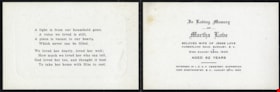
Memorial cards for Martha Love
https://search.heritageburnaby.ca/link/museumdescription10093
- Repository
- Burnaby Village Museum
- Date
- 1920
- Collection/Fonds
- Love family fonds
- Description Level
- File
- Physical Description
- 1 folder of textual records
- Scope and Content
- File consists of a three memorial cards for Martha Love which read: "In Loving Memory / OF / Martha Love / BELOVED WIFE OF JESSE LOVE / CUMBERLAND ROAD, BURNABY, B.C. / Died August 24RD. 1920 / AGED 62 YEARS / INTERRED IN I.O.O.F. CEMETERY, SAPPERTON / NEW WESTMINSTER, B.C., AUGUST 26TH, 1920". A s…
- Repository
- Burnaby Village Museum
- Collection/Fonds
- Love family fonds
- Description Level
- File
- Physical Description
- 1 folder of textual records
- Scope and Content
- File consists of a three memorial cards for Martha Love which read: "In Loving Memory / OF / Martha Love / BELOVED WIFE OF JESSE LOVE / CUMBERLAND ROAD, BURNABY, B.C. / Died August 24RD. 1920 / AGED 62 YEARS / INTERRED IN I.O.O.F. CEMETERY, SAPPERTON / NEW WESTMINSTER, B.C., AUGUST 26TH, 1920". A short, religious poem is printed on the inside face of the card. "IN LOVING / MEMORY" with an image of a rose is printed on the front face of the card.
- History
- See extensive history of Love Family and Love farmhouse located at Burnaby Village Museum.
- Accession Code
- BV012.31.25
- Access Restriction
- No restrictions
- Reproduction Restriction
- No known restrictions
- Date
- 1920
- Media Type
- Textual Record
- Scan Resolution
- 600
- Scan Date
- 7-May-20
- Scale
- 100
- Notes
- Title based on content of file
Images

Reeve Alexander K. McLean
https://search.heritageburnaby.ca/link/museumdescription3038
- Repository
- Burnaby Village Museum
- Date
- [between 1921 and 1928]
- Collection/Fonds
- Roy Bernard Raymer fonds
- Description Level
- Item
- Physical Description
- 1 photograph : sepia ; 15 x 10 cm (sight) in frame 19 x 11 cm
- Scope and Content
- Photograph of Burnaby Reeve Alexander K. McLean. Alexander McLean served as the Reeve of Burnaby from 1921-1926 and again in 1928, and was a Council member in 1920.
- Repository
- Burnaby Village Museum
- Collection/Fonds
- Roy Bernard Raymer fonds
- Description Level
- Item
- Physical Description
- 1 photograph : sepia ; 15 x 10 cm (sight) in frame 19 x 11 cm
- Material Details
- Photograph is matted and framed, with text printed on matte board reading: "The Stride Studios / NEW WESTMINSTER, B.C.".
- Scope and Content
- Photograph of Burnaby Reeve Alexander K. McLean. Alexander McLean served as the Reeve of Burnaby from 1921-1926 and again in 1928, and was a Council member in 1920.
- Names
- McLean, Alexander K.
- Accession Code
- HV977.121.4
- Access Restriction
- No restrictions
- Reproduction Restriction
- No known restrictions
- Date
- [between 1921 and 1928]
- Media Type
- Photograph
- Photographer
- Stride, Charles Edgar
The Dominion high school arithmetic
https://search.heritageburnaby.ca/link/museumlibrary5081
- Repository
- Burnaby Village Museum
- Collection
- Special Collection
- Material Type
- Book
- Accession Code
- X3253
- Call Number
- 513 DOM
- Place of Publication
- Toronto
- Publisher
- W. J. Gage & Company, Limited
- Publication Date
- 1921
- Physical Description
- viii, 9-339 p. ; 19 cm.
- Inscription
- "Harold Yallop, Div. 10," [handwritten in dark ink on t.p. verso] "H. Morey & Co. Booksellers & Stationers 891 Columbia St New Westminster, B.C. [stamped in faded dark ink on back endpaper]
- Library Subject (LOC)
- Arithmetic--Textbooks
- Mathematics--Textbooks
- Mathematics--Historical texts
- Notes
- "Authorized for use in the schools of Manitoba and British Columbia" --t.p.
Map of Burnaby Municipality
https://search.heritageburnaby.ca/link/museumdescription9669
- Repository
- Burnaby Village Museum
- Date
- [1922]
- Collection/Fonds
- Ronald G. Scobbie collection
- Description Level
- Item
- Physical Description
- 1 map : black ink ; 66.5 x 54 cm, on waxed linen sheet 70.5 x 48.5 cm
- Scope and Content
- Item consists of a map of the Burnaby Municipality. The map identifies various land features such as: District Lots with names of property owners and parks, wards, railways, roads and water ways.
- Repository
- Burnaby Village Museum
- Collection/Fonds
- Ronald G. Scobbie collection
- Description Level
- Item
- Physical Description
- 1 map : black ink ; 66.5 x 54 cm, on waxed linen sheet 70.5 x 48.5 cm
- Material Details
- Scale 1:31680
- Scope and Content
- Item consists of a map of the Burnaby Municipality. The map identifies various land features such as: District Lots with names of property owners and parks, wards, railways, roads and water ways.
- Creator
- Hill, Albert James
- Accession Code
- BV003.83.42
- Access Restriction
- No restrictions
- Reproduction Restriction
- No known restrictions
- Date
- [1922]
- Media Type
- Cartographic Material
- Notes
- Transcribed title
- Map is signed by "Albert J. Hill / Civil Engineer / and / Provincial Land Surveyor / New Westminster / B.C."
- Title on map reads: "Map / of / Burnaby Municipality"
- Scale: "40 chs = 1 in."
Elementary geometry: theoretical and practical
https://search.heritageburnaby.ca/link/museumlibrary1539
- Repository
- Burnaby Village Museum
- Collection
- Special Collection
- Material Type
- Book
- Accession Code
- BV985.3837.1
- Call Number
- 516 GOD
- Edition
- 3rd ed.
- Place of Publication
- London
- Publisher
- The MacMillan Company
- Publication Date
- 1922
- Printer
- Cambridge University Press
- Physical Description
- vi-xxiii; 395 p. : diagrs ; 19 cm.
- Inscription
- "Geometry Book Marjorie Watt Adams D.C.H.S." [handwritten on dustcover] "1114 - 8th Ave. New Westminster, B.C." [inner cover] "Nixon's Book Store [stamped upside down] 7 4"
- Library Subject (LOC)
- Geometry--Textbooks
- Mathematics--Historical texts
- Mathematics--Textbooks
- Notes
- Author's given name and dates: Godfrey, C. (Charles), 1873-1924
- Author's given name: Siddons, A. W. (Arthur Warry)
Tennyson's Idylls of the king
https://search.heritageburnaby.ca/link/museumlibrary1879
- Repository
- Burnaby Village Museum
- Collection
- Special Collection
- Material Type
- Book
- Accession Code
- HV982.24.15
- Call Number
- 821.8 TEN 1922
- Contributor
- French, Charles Wallace, 1858-1920
- Place of Publication
- New York
- Publisher
- Macmillan
- Publication Date
- 1922
- Series
- Macmillan's pocket classics
- Printer
- Norwood Press
- Physical Description
- xxiv, 434 p. : front ; 15 cm.
- Inscription
- Front endpaper: "Place stamp here" [written in pencil] "R.A. Pound 720 - Royal Ave New Westminster B.C. May 1 1925" [written in pencil] Back endpaper: "R.A.P. MB 60" [written in pencil] "Nixons Book Store New Westminster, B.C." [stamped in blue ink]
- Library Subject (LOC)
- English literature--Historical texts
- Poetry--historical texts
- Notes
- edited with introduction and notes by Charles W. French
- Includes index.
- Copy of book published in 1912 available.
Lorna Doone: a romance of Exmoor
https://search.heritageburnaby.ca/link/museumlibrary3169
- Repository
- Burnaby Village Museum
- Collection
- Special Collection
- Material Type
- Book
- Accession Code
- HV972.165.137
- Call Number
- 800 BLA
- Contributor
- Warren, T. Herbert (Thomas Herbert), 1853-1930
- Place of Publication
- London
- Publisher
- Oxford University Press
- Publication Date
- 1922
- Series
- The World's Classics
- Printer
- Oxford University Press
- Physical Description
- xxx, 656, 8 p. : port
- Inscription
- "W57", in pen inside front cover "Marjorie W. Adams / D.C. H.S. / New Westminster / B.C.", handwritten in brown ink on front endpaper "Latin Prose" notes, handwritten in blue ink on reverse of pre-title page "Questions", list of 10, handwritten in blue ink on reverse of portrait page "R.D. Blackmore / John Ridd", handwritten in pencil below portrait "R+ / 75", in pencil inside back cover, with figures "MIISH"?, in ink on page edges
- Library Subject (LOC)
- Fiction--19th century
Ministry of Agriculture papers
https://search.heritageburnaby.ca/link/archivedescription64437
- Repository
- City of Burnaby Archives
- Date
- 1924-1929
- Collection/Fonds
- Burnaby Historical Society fonds
- Description Level
- File
- Physical Description
- 1 file of textual records
- Scope and Content
- File of Government of Northern Ireland Ministry of Agriculture papers pertaining to poultry farming (sent to R. Bancroft of Edmonds).
- Repository
- City of Burnaby Archives
- Date
- 1924-1929
- Collection/Fonds
- Burnaby Historical Society fonds
- Subseries
- Bancroft family subseries
- Physical Description
- 1 file of textual records
- Material Details
- Mailing envelope accompanying papers reads: "Mr. R. Bancroft, / Edmonds P.O., / New Westminster, B.C., / CANADA."
- Description Level
- File
- Record No.
- MSS110-025
- Accession Number
- BHS2004-06
- Scope and Content
- File of Government of Northern Ireland Ministry of Agriculture papers pertaining to poultry farming (sent to R. Bancroft of Edmonds).
- Media Type
- Textual Record
- Notes
- Title based on contents of file