Narrow Results By
Subject
- Advertising Medium 1
- Agricultural Tools and Equipment 1
- Agriculture - Crops 1
- Agriculture - Farms 3
- Agriculture - Fruit and Berries 2
- Animals - Cows 1
- Animals - Goats 1
- Animals - Horses 2
- Buildings 2
- Buildings - Civic - Museums 1
- Buildings - Commercial 2
- Buildings - Commercial - Department Stores 18
Creator
- Alger, Horatio, Jr., 1832-1899 1
- Askey, Jim 1
- Benson, Don, 1933- 1
- Blackmore, R. D., (Richard Doddridge), 1825-1900 1
- Black, Newton Henry, 1874-1961 1
- Brown, William Thomas 1
- Buckley, Arabella B. (Arabella Burton), 1840-1929 1
- Burlin, Mauritz 1
- Burnett, Geoffrey K. 4
- Burnett & McGugan, Engineers and Surveyors 10
- Chambers, L. B. 1
- Christy, Howard Chandler, 1873-1952 1
Person / Organization
- Armstrong Avenue School 1
- Baehr, G. A. 1
- Bank of Nova Scotia 1
- Barnet School 1
- Boy Scouts of Canada 1
- Brackman-Ker Milling Company 1
- British Columbia Provincial Police 1
- British Columbia Telephone Company 1
- Burnaby Historical Society 2
- Burnaby Mountain Centennial Park 1
- Burnaby Village Museum 1
- Burton, Charles Luther 3
![Louis Claude Hill's Farm, Burnaby, BC, [1909] thumbnail](/media/hpo/_Data/_BVM_Images/1973/1973_0040_0004_001.jpg?width=280)
Louis Claude Hill's Farm, Burnaby, BC
https://search.heritageburnaby.ca/link/museumdescription3064
- Repository
- Burnaby Village Museum
- Date
- [1909]
- Collection/Fonds
- Burnaby Village Museum Photograph collection
- Description Level
- Item
- Physical Description
- 1 photograph : b&w ; 12.2 x 17.6 cm mounted on cardboard 22.7 x 27.4 cm
- Scope and Content
- Photograph of a farm with men, a horse and wagon, and children in a field. An annotation on the back of one of the photos reads, "The foreground farm property stood at the corner of Sperling Avenue (formerly known as the Pole Line Road) and Buckingham. The white house in the left centre was the …
- Repository
- Burnaby Village Museum
- Collection/Fonds
- Burnaby Village Museum Photograph collection
- Description Level
- Item
- Physical Description
- 1 photograph : b&w ; 12.2 x 17.6 cm mounted on cardboard 22.7 x 27.4 cm
- Scope and Content
- Photograph of a farm with men, a horse and wagon, and children in a field. An annotation on the back of one of the photos reads, "The foreground farm property stood at the corner of Sperling Avenue (formerly known as the Pole Line Road) and Buckingham. The white house in the left centre was the residence of Miss Woodward, her mother and sister. It was the first post office at 'Burnaby Lake' and the site of the kindergarten school of Miss Harriet Woodward. It later became the United Church. / The open field in the distance above the horse's head and people in the field is the field in front of the 'Manor House' which was built by Mr. Bateman in the 1920's. To the right of and beyond the white house partly hidden by the trees can be seen some of the buildings associated with the Hill farm on Deer Lake Ave. which by the date (1909) of this photo had been sold. The distant tall trees (center) stand on the site of the Municipal Buildings (DesBirsays Woods)." An annotation on the back of the other photograph reads, "Formerly belonging to Malcom Nicolson / App. 1908." Annotations at the bottom front of the photograph read, "L. Claude Hill's Farm, Burnaby, BC."
- Subjects
- Agriculture - Crops
- Agricultural Tools and Equipment
- Animals - Horses
- Occupations - Farmers
- Agriculture - Farms
- Geographic Access
- Buckingham Avenue
- Sperling Avenue
- Accession Code
- HV973.40.4
- Access Restriction
- No restrictions
- Reproduction Restriction
- No known restrictions
- Date
- [1909]
- Media Type
- Photograph
- Historic Neighbourhood
- Burnaby Lake (Historic Neighbourhood)
- Planning Study Area
- Morley-Buckingham Area
- Scan Resolution
- 600
- Scan Date
- 2023-05-09
- Scale
- 100
- Notes
- Title based on contents of photograph
- 1 b&w duplicate photograph accompanying
- Text on first image "L Claude Hill's Farm, Burnaby B C", incorporated into the image at the bottom edge of the photograph. "app 1909" pencilled in following above on the bottom edge of the image "L. Claude / Hill / Broadview", pencilled on the matt below the image. "The foreground farm property stood at the / Corner of Sperling Ave. (formerly known as Pole Line Road) / and Buckingham. The white house in the left / centre was the residence of Miss Woodward, her mother / and sister. It was the first post ofice at "Burnaby Lake" / and the site of the kindergarten school of Miss / Harriet Woodward. It later became the United / Church. / The open field in the distance above / the horses head and people in the field is / the field in front of the "Manse House" which / was built by Mr. Bateman in the 1920's. To the / right of and beyond the white house partly hidden / by the trees can be seen some of the buildings / associated with the Hill farm on Deer Lake Ave. / which by the date (1909) of this photo had been / sold. The distant tall trees (center) stand on the site of / the Municipal Buildings (DesBirsays Woods)", hand written in blue ink on the reverse side of the matt. It is not indicated who wrote the note. "OR MASTER / 973.40.4", pencilled in the lower right corner of reverse side of matt. "W. T. COOKSLEY / NEW WESTMINSTER, B.C."printed with very little contrast on the gray mattboard, below the lower right corner of the photograph Text on second image. "L Claude Hill's Farm, Burnaby B C", incorporated into the image at the bottom edge of the photograph. "Claude surveying the haying", pencilled on the reverse side of the matt. "Formerly belonging to Malcolm Nicholson / app 1908", hand writen in blue ink on the reverse side of the matt. "H.V.973.40.4. OR. MASTER", hand printed on the bottom left corner of the reverse side of the matt. "W. T. COOKSLEY / NEW WESTMINSTER, B.C."printed with very little contrast on the gray mattboard, below the lower right corner of the photograph
Images
![Louis Claude Hill's Farm, Burnaby, BC, [1909] thumbnail](/media/hpo/_Data/_BVM_Images/1973/1973_0040_0004_001.jpg)

![Survey and Subdivision plans in New Westminster District Group 1 – Burnaby
, [1909] thumbnail](/media/hpo/_Data/_BVM_Cartographic_Material/1977/1977_0093_0005a_001.jpg?width=280)
Survey and Subdivision plans in New Westminster District Group 1 – Burnaby
https://search.heritageburnaby.ca/link/museumdescription6974
- Repository
- Burnaby Village Museum
- Date
- [1909]
- Collection/Fonds
- Burnaby Village Museum Map collection
- Description Level
- File
- Physical Description
- 5 plans : blueprint ink on paper + 1 plan : black ink on paper mounted on 2 sides of cardboard ; 76 cm x 102 cm
- Scope and Content
- Item consists of a large board of three New Westminster District Gp 1 - subdivision plans mounted on one side and three New Westminster District Gp 1 - subdivision plans mounted on the other side. Side A: 1. Blueprint "Plan / of Subdivision of / Lot 1 and the West Half of Lot 2 / in the Subdivis…
- Repository
- Burnaby Village Museum
- Collection/Fonds
- Burnaby Village Museum Map collection
- Description Level
- File
- Physical Description
- 5 plans : blueprint ink on paper + 1 plan : black ink on paper mounted on 2 sides of cardboard ; 76 cm x 102 cm
- Material Details
- Scales [between 1:1584 and 1:3960]
- Index number on edge of board reads: "5"
- Scope and Content
- Item consists of a large board of three New Westminster District Gp 1 - subdivision plans mounted on one side and three New Westminster District Gp 1 - subdivision plans mounted on the other side. Side A: 1. Blueprint "Plan / of Subdivision of / Lot 1 and the West Half of Lot 2 / in the Subdivision of / Lot 136, 131, 44 and 78 Gr.1 / District of New Westminster , B.C." . Plan is bordered by Johnston Road, Pole Line Road, V.W.& Y. Railway and Lot 43. (Geographic location: Burnaby) 2. Blueprint "Plan / of Subdivision / of a portion / of / Lot 13, Gr.1 / New Westminster District". Plan is bordered by north east of Cariboo Street and Armstrong Street with Lillooet Street bisecting through the middle. (Geographic location: Burnaby) 3. Blueprint "Plan / of Subdivision / of / Lots 2 and 4 / Group One / New Westminster District." Plan is bordered west of North Road, north of Lot 1 and south of Lot 6. (Geographic location: Burnaby) Side B: 1. Blueprint plan of "Diversion of Gunn Road / in / Lots 10 & 4 / Group One." Plan idenfies V.W.& Y. Railway alongside proposed diversion of Gunn Road. (Geographic location: Burnaby) 2. Blueprint "Survey and Subdivision / of / Lot 12 and a portion of Lot 13 / Group One / New Westminster District." Plan ids bordered by Gunn Rd. to the north, and Cariboo Road / Lot s 10 and 14 to the east and Lot 1 to the west with V.W.& Y. Rwy and Brunette River running through diagonally. (Geographic location: Burnaby) 3. Blueprint "Plan of Subdivision / of / Lot 97, Group 1 / New Westminster District." Plan is bordered by Webster Road, Power House Road, Lot 94 and Lot 93 to the north with Jenn's Rd. running north through the centre and Vancouver & New Westminster Rd. and New Westminster Vancouver Tramway running east-west. Handwritten annotation in pencil over top of plan reads: "Cancelled" (Geographic location: Burnaby)
- Accession Code
- HV977.93.5
- Access Restriction
- No restrictions
- Reproduction Restriction
- No known restrictions
- Date
- [1909]
- Media Type
- Cartographic Material
- Scan Resolution
- 300
- Scale
- 72
- Notes
- Title based on contents of file
- Scale is measured in chains. (One chain equals 792 inches)
- The term "Lot" can also refer to a "District Lot”
Images
![Survey and Subdivision plans in New Westminster District Group 1 – Burnaby
, [1909] thumbnail](/media/hpo/_Data/_BVM_Cartographic_Material/1977/1977_0093_0005a_001.jpg)

The crisis
https://search.heritageburnaby.ca/link/museumlibrary514
- Repository
- Burnaby Village Museum
- Collection
- Special Collection
- Material Type
- Book
- Accession Code
- BV986.53.21
- Call Number
- 813.5 CHU
- Contributor
- Christy, Howard Chandler, 1873-1952
- Place of Publication
- New York
- Publisher
- Grosset & Dunlap
- Publication Date
- 1909
- Series
- MacMillan's Standard Library
- Printer
- Norwood Press
- Physical Description
- viii, 522, [12] p. : ill.
- Inscription
- "Violet MacTrodden / New Westminster / B.C.", handwritten in brown ink on front endpaper "M. Trodden. / Cl.2 / W.M.F.H.", handwritten in pencil on front endpaper "377", printed in ink on front endpaper
- Notes
- American novelist not the former British Prime Minister
![Dugald Campbell Patterson, Sr, [between 1910 and 1914] (date of original), copied 1977 thumbnail](/media/hpo/_Data/_BVM_Images/1977/1977_0099_0006_001.jpg?width=280)
Dugald Campbell Patterson, Sr
https://search.heritageburnaby.ca/link/museumdescription564
- Repository
- Burnaby Village Museum
- Date
- [between 1910 and 1914] (date of original), copied 1977
- Collection/Fonds
- Burnaby Village Museum Photograph collection
- Description Level
- Item
- Physical Description
- 1 photograph : b&w ; 20.32 x 25.4 cm print
- Scope and Content
- Photograph portrait of Dugald Campbell Patterson, Sr.
- Repository
- Burnaby Village Museum
- Collection/Fonds
- Burnaby Village Museum Photograph collection
- Description Level
- Item
- Physical Description
- 1 photograph : b&w ; 20.32 x 25.4 cm print
- Scope and Content
- Photograph portrait of Dugald Campbell Patterson, Sr.
- History
- Dugald Campbell Patterson Sr. arrived in Burnaby in 1894. He worked for Armstrong Morrison & Balfour and later became foreman boilermaker for the Vancouver Engineering Works. He was the first postmaster of Edmonds in 1909, and was elected a school trustee in 1912. He was a Director of the British Columbia Electric and Water Heat Company and was a member of the New Westminster Board of Trade. He founded an insurance and real estate company in Burnaby and New Westminster. Dugald Campbell Patterson Sr. was born in Partick, Scotland on January 2, 1860. He attended the Glasgow common school, and worked as a ship joiner at Barclay Curle & Company (founded in 1818) in Whiteinch, Scotland. After some years of study, he was employed in the Anchor Line Shipyards (founded in 1856) in Partick. Dugald arrived in Canada on July 1, 1884, and would soon add a second "T" to the spelling of his last name (changing it from "Paterson" to "Patterson"). He married Frances Mabel Webb on February 7, 1891. Together they helped form the Central Park Horticultural Society.Known for his expertise in the field of engineering, Dugald accepted a unique commission at the beginning of World War One. He travelled overseas to supervise a group of Canadians in the construction of submarines on the Clyde River in Glasgow. It was here that he sustained an injury which left him in a wheel chair. Upon his return home, he remained active in both municipal affairs and the arts. He developed a plan that would preserve ravines as parks in Burnaby, and he published a book of poetry. Dugald also served his communty through his membership in the Knights of Pythias,the Canadian Order of Forresters and the Home Reunion Association. Dugald died in Vancouver, BC on June 25, 1931. [Biography provided by Raymond Reitsma].
- Accession Code
- HV977.99.6
- Access Restriction
- No restrictions
- Reproduction Restriction
- May be restricted by third party rights
- Date
- [between 1910 and 1914] (date of original), copied 1977
- Media Type
- Photograph
- Scan Resolution
- 600
- Scan Date
- 2023-07-11
- Photographer
- Ritchie, Samuel J.
- Notes
- Title based on contents of photograph
- An annotation on the back of the photograph reads: "B. Paterson's [sic] father (Dougal [sic] Campbell Patterson). Owner Vulcan Iron Works, New Westminster, B.C. (He also started real estate business at Edmonds and K'way [Kingsway]."
- For more information on D.C. Patterson's family, see Michael Sone's book, "Pioneer Tales of Burnaby," pg. 60.
- The photographer Samuel J. Ritchie was active in New Westminster from 1910 to 1914. For reference, see David Mattison's Camera Workers: The British Columbia Photographic Directory, 1858-1950 - R - Volume 2 (1901-1950)
Images
![Dugald Campbell Patterson, Sr, [between 1910 and 1914] (date of original), copied 1977 thumbnail](/media/hpo/_Data/_BVM_Images/1977/1977_0099_0006_001.jpg)

First Central Park B.P. Boy Scouts, 1910
https://search.heritageburnaby.ca/link/museumdescription1055
- Repository
- Burnaby Village Museum
- Date
- 1910
- Collection/Fonds
- Burnaby Village Museum Photograph collection
- Description Level
- Item
- Physical Description
- 1 photograph : b&w ; 12.1 x 17.3 cm mounted on cardboard 22.0 x 27.0 cm
- Scope and Content
- Photograph of the First Central Park troop of Boy Scouts. All but two of them are in uniform, standing at attention. There are 22 boys and 7 men. A man in the centre is holding a flagpole with a Union Jack attached. The Boy Scouts are standing on a cleared field behind which is a building and fores…
- Repository
- Burnaby Village Museum
- Collection/Fonds
- Burnaby Village Museum Photograph collection
- Description Level
- Item
- Physical Description
- 1 photograph : b&w ; 12.1 x 17.3 cm mounted on cardboard 22.0 x 27.0 cm
- Scope and Content
- Photograph of the First Central Park troop of Boy Scouts. All but two of them are in uniform, standing at attention. There are 22 boys and 7 men. A man in the centre is holding a flagpole with a Union Jack attached. The Boy Scouts are standing on a cleared field behind which is a building and forest growth. The location may be Central Park. A caption printed on the bottom front of the frame reads, "First Central Park / B.P. Boy Scou [sic] / 1910." Printed on the lower right front of the frame, "W. Brown, Photo. / New Westminster, B.C."
- Names
- Boy Scouts of Canada
- Geographic Access
- Central Park
- Imperial Street
- Street Address
- 3883 Imperial Street
- Accession Code
- HV973.152.2
- Access Restriction
- No restrictions
- Reproduction Restriction
- No known restrictions
- Date
- 1910
- Media Type
- Photograph
- Historic Neighbourhood
- Central Park (Historic Neighbourhood)
- Planning Study Area
- Maywood Area
- Related Material
- See HV973.152.1 for another photograph of the first central park BP boy scouts.
- Scan Resolution
- 600
- Scan Date
- 2023-06-06
- Photographer
- Brown, William Thomas
- Notes
- Title based on caption of photograph
Images


![Survey and Subdivision plans in New Westminster District Group 1 and Group 2 – Vancouver, ʷməθkʷəy̓əm (Musqueam) Indian Reserve, Burnaby, Surrey
, [1910-1911] thumbnail](/media/hpo/_Data/_BVM_Cartographic_Material/1977/1977_0093_0017_001.jpg?width=280)
Survey and Subdivision plans in New Westminster District Group 1 and Group 2 – Vancouver, ʷməθkʷəy̓əm (Musqueam) Indian Reserve, Burnaby, Surrey
https://search.heritageburnaby.ca/link/museumdescription6986
- Repository
- Burnaby Village Museum
- Date
- [1910-1911]
- Collection/Fonds
- Burnaby Village Museum Map collection
- Description Level
- File
- Physical Description
- 9 plans : 4 plans : blueprint ink on paper + 4 plans : black ink on paper + 1 plan : graphite on paper mounted on 2 sides of cardboard 76 x 102 cm
- Scope and Content
- File consists of a large board of three survey plans in New Westminster District Group 1 mounted on one side and six survey and subdivision plans of District Lot 85, New Westminster District Group 1 mounted on the other side. Side A: 1. Plan : blueprint on paper ; 30.5 x 80 cm. Title reads: "Fras…
- Repository
- Burnaby Village Museum
- Collection/Fonds
- Burnaby Village Museum Map collection
- Description Level
- File
- Physical Description
- 9 plans : 4 plans : blueprint ink on paper + 4 plans : black ink on paper + 1 plan : graphite on paper mounted on 2 sides of cardboard 76 x 102 cm
- Material Details
- Scales vary (One chain equals 792 inches)
- Indexed number on tape on edge of board reads "17"
- Scope and Content
- File consists of a large board of three survey plans in New Westminster District Group 1 mounted on one side and six survey and subdivision plans of District Lot 85, New Westminster District Group 1 mounted on the other side. Side A: 1. Plan : blueprint on paper ; 30.5 x 80 cm. Title reads: "Fraser River Bridge / Plan of South Approach". Plan covers area of land north of the Fraser River and Great Northern Railway with approach for a bridge running through the "ʷməθkʷəy̓əm (Musqueam) Indian Reserve" (ʷməθkʷəy̓əm (Musqueam) First Nation) and lots marked as Dominion Government and the east half of Lot 2 identified as "C. F. Brown" "Plan 851". Plan is identified as "Plan 851 / traced / Mar. 17, 1911". (Geographic location in Vancouver) Scale: 100 feet = 1 inch, Signed by Albert J. Hill / P.L.S." 2. Plan : blueprint on paper ; 36.5 x 35 cm (no title). Includes three plans of lots on the east and west sides of North Road. Note on bottom of blueprint reads: "I.E.B. McKay Surveyor General - hereby certify / that this is a correct tracing from the field / notes of the Royal Engineers on file in the / Lands Department / E.B. McKay (signature) / Surveyor General / Victoria B.C. April 11th 1911" . Plan in top left titled "Page 11 / Vol. 1. / R.E. Notes" covers District Lots east of North Road including Lot 5, Lot 7, Lot 41, Lot 9 and Lot 107 in Coquitlam. Plan in top right corner titled "Page 17 / Vol. 1. / R.E. Notes" covers District Lots east of North Road including Lot 104, Lot 54, Lot 105, Lot 55, Lot 106, Lot 9 and Lot 107 in Coquitlam and Port Moody. Plan in lower left corner titled "Page 15 / Vol. 1 / R.E. Notes" covers District Lots west of North Road including Lot 147, Lot 148, Lot 100, Lot 15 in Burnaby. 3. Plan : blue print on paper ; 29.5 x 41.5 cm. (no formal title). Plan of the North 1/2 of Section 18. Plan covers area in the "North 1/2 of Sec.18 B.5 N RGE 1 W" and "Sec. 18 B.5 N. RGE 1 W" bordered by Section 7, Section 13, Section 17 and Section 19. Bon Accord Road runs through Sec. 18. The plan is signed by surveryor "I.H. Neville Smith... C.E.B.C.L.S. / Mar. 26th 1910" and signed by "Ludwig Pillath". (Geographic location: Surrey) Side B: 1. Plan : blueprint on paper ; 43.5 x 49.5 cm. Title reads: "Plan / of Subdivision / of a Portion / of / Lot 85 / Group One / New Westminster District. Plan covers portion of land east of Deer Lake and Pole Line Road (Sperling Avenue) and south of Hastings Road in District Lot 85 in Burnaby with section 4 and a portion of section 2 coloured in red. Plan is signed by "Albert J. Hill, B.C.L.S." Plan is initialed by: "RB" [sic] (in blue pencil crayon) Scale: 4 chains = 1 inch 2. Plaln : black black ink on linen ; 39 x 37 cm. Title reads: "L.C. Hill's Property, / Burnaby". Plan covers a triangular portion of land east of Pole Line Road (Sperling Avenue) and south of Hastings Road in District Lot 85 in Burnaby. Plan is intitaled by "RB" [sic] (in blue pencil crayon). Scale: 3 chains = 1 mile 3. Plan : graphite on paper ; 23 x 17 cm. Title reads: "Portion of Lot 85 / Gr.1". Plan covers portion of land north east of Deer Lake and west of Pole Line Road (now Sperling Avenue) in District Lot 85 in Burnaby. Plan is stamped in red ink: "Albert J. Hill, Civil Engineer". Plan is initialed by: "RB" [sic] (in blue pencil crayon). Scale: 1 chain = 1 inch 4. Plan : black ink on linen ; 16 x 19 cm. Title reads: "Lot 85". Plan covers the intersection of Pole Line Road (Sperling Avenue) and Hastings Road at the north west section of District Lot 79 and District Lot 85 in Burnaby. Plan is stamped: "A.J. Hill, Civil Engineer" with identitifed in blue pencil crayon. 5. Plan : black ink on paper ; 28.5 x 37 cm. (no formal title) Plan covers an area of land, west of Pole Line Road (Sperling Avenue) and south of Deer Lake in District Lot 85 in Burnaby. Plan is initialed by: "RB" [sic] (in blue pencil crayon) 6. Plan : black ink on paper ; 21 x 34 cm (no formal title). Plan covers an area of land, west of Pole Line Road (Sperling Avenue) and south of Deer Lake in District Lot 85 in Burnaby. Plan is initialed by: "RB" [sic] (in blue pencil crayon)
- Accession Code
- HV977.93.17
- Access Restriction
- No restrictions
- Reproduction Restriction
- No known restrictions
- Date
- [1910-1911]
- Media Type
- Cartographic Material
- Historic Neighbourhood
- Burnaby Lake (Historic Neighbourhood)
- Burquitlam (Historic Neighbourhood)
- Planning Study Area
- Morley-Buckingham Area
- Douglas-Gilpin Area
- Scan Resolution
- 600
- Scan Date
- 2023-06-26
- Notes
- Title based on contents of file
- Scale is measured in chains and feet. (One chain equals 792 inches).
- The term "Lot" also refers to a "District Lot”
- Some plans are stamped: "Albert J. Hill, Civil Engineer / and / Provincial Land Surveyor, / New Westminster, / B.C." and intialed: "RB" [sic]
Zoomable Images
![Survey and Subdivision plans in New Westminster District Group 1 and Group 2 – Vancouver, ʷməθkʷəy̓əm (Musqueam) Indian Reserve, Burnaby, Surrey
, [1910-1911] thumbnail](/media/hpo/_Data/_BVM_Cartographic_Material/1977/1977_0093_0017_003_seadragon/1977_0093_0017_003.jpg?w=280)
Survey and Subdivision plans in New Westminster District Group 1 and Group 2 – Vancouver, ʷməθkʷəy̓əm (Musqueam) Indian Reserve, Burnaby, Surrey , [1910-1911]
Zoom into Image
Memorandum re certificate of site in name of Jesse Love Lot 1 of Lot 25
https://search.heritageburnaby.ca/link/museumdescription18799
- Repository
- Burnaby Village Museum
- Date
- 23 Sep. 1910
- Collection/Fonds
- Love family fonds
- Description Level
- Item
- Physical Description
- 1 p. of textual records
- Scope and Content
- Item consists of a memorandum from the Land Registry Office addressed to Jesse Love, re certificate of site no. 3585 in name of Jesse Love concerns Lot 1 of Lot 25, Group I New Westminster District.
- Repository
- Burnaby Village Museum
- Collection/Fonds
- Love family fonds
- Description Level
- Item
- Physical Description
- 1 p. of textual records
- Scope and Content
- Item consists of a memorandum from the Land Registry Office addressed to Jesse Love, re certificate of site no. 3585 in name of Jesse Love concerns Lot 1 of Lot 25, Group I New Westminster District.
- Accession Code
- BV992.26.19
- Access Restriction
- No restrictions
- Reproduction Restriction
- No known restrictions
- Date
- 23 Sep. 1910
- Media Type
- Textual Record
- Notes
- Title based on contents of item
- Memorandum, buff paper with purple print, filled in by hand in black ink; "MEMORANDUM" "FROM THE LAND REGISTRY OFFICE, NEW WESTMINSTER, B.C." "23rd Sept 1910", date has been corrected from pre-printed "190"; "To" "Jesse Love" "East Burnaby P.O." "Re:" and dotted line, blank; "I beg to acknowledge receipt of", then "your favour of" is stroked out, dotted line, stroked out "with enclosure as stated"; handwritten "Certificate of Title No. 3585 F in name of Jesse Love concerns Lot 1 of Lot 22 Group I N.W.D."; dotted line at bottom "District Registrar." has signature "C.S. Keith" and "RHC"; small print at upper left, "Address all letters to the DISTRICT REGISTRAR OF TITLES, NEW WESTMINSTER, B.C."; red stamp at lower left, "LAND REGISTRY OFFICE, NEW WESTMINSTER, B.C." "RECEIVED" "SEP 23 1910", and two clock faces showing time; left hour clock shows 11, right minute clock shows 19, small dial above and between has arrow pointing down slightly in PM side.
The key of heaven : a manual of prayer
https://search.heritageburnaby.ca/link/museumlibrary4863
- Repository
- Burnaby Village Museum
- Collection
- Special Collection
- Material Type
- Book
- Accession Code
- BV985.3899.1
- Call Number
- 282 MHW
- Place of Publication
- Milwaukee, Wis.
- Publisher
- M. H. Wiltzius Co.
- Publication Date
- 1910
- Physical Description
- 296, 224 p. : ill. ; 10 cm.
- Inscription
- "Mary Byrne / Souvenir of First Communion June 12, 1910 / St. Ann's Convent New Westminster, B.C." -- handwritten in ink on the second page.
- Subjects
- Religions
- Religions - Christianity
- Names
- Byrne, Mary
- Notes
- "Imprimatur SEBASTIANUS GEBHARDUS Archiepiscopus Milwauchiensis" -- title page verso.
- The key of heaven (296 p.) -- The epistles and gospels for the Sundays and principal festivals (224 p.)
- Made in Germany - on 296 p. ; Printed in Begium - 224 p.
- Includes index.
Deed of Land between Smith, Reid and Lindahl re Subdivision 8 of Lot 5 Block 13
https://search.heritageburnaby.ca/link/museumdescription18782
- Repository
- Burnaby Village Museum
- Date
- 13 Mar. 1911
- Collection/Fonds
- Love family fonds
- Description Level
- Item
- Physical Description
- 1 p. of textual records
- Scope and Content
- Item consists of a Deed of Land between Frank P. Smith and William T. Reid and Henrick Lindahl for Subdivision eight (8) of South Half of Lot five (5), Suburban Block Thirteen (XIII).
- Repository
- Burnaby Village Museum
- Collection/Fonds
- Love family fonds
- Description Level
- Item
- Physical Description
- 1 p. of textual records
- Scope and Content
- Item consists of a Deed of Land between Frank P. Smith and William T. Reid and Henrick Lindahl for Subdivision eight (8) of South Half of Lot five (5), Suburban Block Thirteen (XIII).
- Accession Code
- BV992.26.2
- Access Restriction
- No restrictions
- Reproduction Restriction
- No known restrictions
- Date
- 13 Mar. 1911
- Media Type
- Textual Record
- Notes
- Title based on contents of item
- "FRANK P. SMITH AND WILLIAM T. REID" "TO" "HENRIK LINDAHL", "Deed of Land" "SITUATE IN" "Subd. 8 Lot Five. Sub. Blk. XIII"; below, printed in decorative border, "REAL ESTATE" "PHONE 169" "J.J. JOHNSTON" "COLUMBIA ST. NEW WESTMINSTER, B.C." "INSURANCE"; overstamped in red with land registry office stamp, "NOT EXAMINED" "MAR 17 1911" "THIS PURPORTS TO BE A DUPLICATE... 27362"; below border, "JACKSON PRINTING COMPANY, NEW WESTMINSTER"; buff paper, legal-sized, black print, pink, white and blue borders; opens out to "This Indenture", between Smith and Reid of New Westminster and Lindahl of New Westminster; for $350 for said parcel; typed, purple carbon paper; signed by Smith and Reid, small red seals; witnessed by Clayton A. Bourne; "FOR WITNESS" signed by J.J.Johnston, Commissioner for taking Affidavits in B.C.
Deed of Land between L. Claude Hill and Frank Smith and William Reid re Subdivision 8 of Lot 5 Block 13
https://search.heritageburnaby.ca/link/museumdescription18784
- Repository
- Burnaby Village Museum
- Date
- 13 Mar. 1911
- Collection/Fonds
- Love family fonds
- Description Level
- Item
- Physical Description
- 1 p. of textual records
- Scope and Content
- Item consists of Item consists of a Deed of Land between L. Claude Hill and Frank P. Smith and William T. Reidl for Subdivision eight (8) of South Half of Lot five (5), Suburban Block Thirteen (XIII).
- Repository
- Burnaby Village Museum
- Collection/Fonds
- Love family fonds
- Description Level
- Item
- Physical Description
- 1 p. of textual records
- Scope and Content
- Item consists of Item consists of a Deed of Land between L. Claude Hill and Frank P. Smith and William T. Reidl for Subdivision eight (8) of South Half of Lot five (5), Suburban Block Thirteen (XIII).
- Accession Code
- BV992.26.4
- Access Restriction
- No restrictions
- Reproduction Restriction
- No known restrictions
- Date
- 13 Mar. 1911
- Media Type
- Textual Record
- Notes
- Title based on contents of item
- document, dated March 13th 1911; "L. CLAUDE HILL" "TO" "FRANK P. SMITH AND WILLIAM T. REID."; "Deed of Land" "SITUATE IN" "Subd. 8. Lot Five Sub. Blk. XIII."; "27361"; overstamped in red with "LAND REGISTRY OFFICE" stamp, "NOT EXAMINED" "...DUPLICATE ONLY..."; printed below inside decorative border, "REAL ESTATE" "PHONE 169" "J.J. JOHNSTON" "COLUMBIA ST NEW WESTMINSTER, B.C." "INSURANCE"; printed below border is "JACKSON PRINTING COMPANY, NEW WESTMINSTER"
- buff paper, folds out to legal-sized; black print, pink, white and blue borders; "This Indenture", all parties from New Westminster; for $350, for parcel named; signed by L. Claude Hill, small red seal; witnessed by Clayton A. Bourne; "FOR WITNESS" section signed March 16, 1911, by J.J. Johnston, Commissioner for taking Affidavits in B.C.;
Deed of Land between George R. Love and Jesse Love re Lot 56 of Lot 7, subdivision of Block 12
https://search.heritageburnaby.ca/link/museumdescription18785
- Repository
- Burnaby Village Museum
- Date
- 16 Sep. 1911
- Collection/Fonds
- Love family fonds
- Description Level
- Item
- Physical Description
- 1 p. of textual records
- Scope and Content
- Item consists of Deed of Land dated September 16, 1911 between George R. Love and Jesse Love for Lot fifty-six (56) of Lot seven (7), Subdivision of Block twelve (12).
- Repository
- Burnaby Village Museum
- Collection/Fonds
- Love family fonds
- Description Level
- Item
- Physical Description
- 1 p. of textual records
- Material Details
- watermark "BERKSHIRE BOND"
- Scope and Content
- Item consists of Deed of Land dated September 16, 1911 between George R. Love and Jesse Love for Lot fifty-six (56) of Lot seven (7), Subdivision of Block twelve (12).
- Accession Code
- BV992.26.5
- Access Restriction
- No restrictions
- Reproduction Restriction
- No known restrictions
- Date
- 16 Sep. 1911
- Media Type
- Textual Record
- Notes
- Title based on contents of item
- document dated Sept. 16th 1911; "George R. Love" "East Burnaby, B.C." "TO" "Jessie Love" "East Burnaby, B.C."; "Deed of Land" "SITUATE IN" "City of New Westminster, B.C."; stamped in red with land registry office stamp, "NOT EXAMINED" "SEP 25 1911" "...DUPLICATE..." "32261"; printed below, "F.J. HART & CO., LTD." "REAL ESTATE, NOTARIES PUBLIC" "CONVEYANCERS" NEW WESTMINSTER, VANCOUVER AND CHILLIWACK, B.C."; at bottom, "JACKSON PRINTING COMPANY, NEW WESTMINSTER"; buff paper, folds out to legal size; pink, blue and white borders; black print, blue typewriting (carbon); "This Indenture", for $1000, for parcel of land Lot 56 of Lot 7, subdivision of Bl.12, suburban, New Westminster, B.C.; subject to indenture of mortgage between George R. Love and The British Columbia Permanent Loan Company, and to agreement for sale with Mr. and Mrs. Morrison; signed by George R. Love, small red seal; witnessed by H.A. Eastman; "FOR MAKER" signed by H.A. Eastman, Sept. 27, 1911; stamp seal "HENRY ALFRED EASTMAN" "BRITISH COLUMBIA" "NOTARY PUBLIC".
Deed of Land between Henry A. Eastman and George R. Love re Lots 55 and 56 of Lot 7 and 12
https://search.heritageburnaby.ca/link/museumdescription18786
- Repository
- Burnaby Village Museum
- Date
- 7 Apr. 1911
- Collection/Fonds
- Love family fonds
- Description Level
- Item
- Physical Description
- 1 p. of textual records
- Scope and Content
- Item consists of Deed of Land dated April 7, 1911 between Henry Alfred Eastman and George R. Love of East Burnaby for Lots fifty-five (55) and fifty-six (56) of Lot seven (7), Block twelve (12) Suburban.
- Repository
- Burnaby Village Museum
- Collection/Fonds
- Love family fonds
- Description Level
- Item
- Physical Description
- 1 p. of textual records
- Material Details
- watermark "BERKSHIRE BOND"
- Scope and Content
- Item consists of Deed of Land dated April 7, 1911 between Henry Alfred Eastman and George R. Love of East Burnaby for Lots fifty-five (55) and fifty-six (56) of Lot seven (7), Block twelve (12) Suburban.
- Accession Code
- BV992.26.6
- Access Restriction
- No restrictions
- Reproduction Restriction
- No known restrictions
- Date
- 7 Apr. 1911
- Media Type
- Textual Record
- Notes
- Title based on contents of item
- document, buff paper, legal-sized; dated April 7th, 1911; "HENRY A. EASTMAN" of New Westminster, B.C. to "GEORGE R. LOVE" of East Burnaby, B.C.; "This Indenture", for the payment of $1400, is for parcels or tracts of land in New Westminster, Lots 55 and 56 of Lot 7, Block 12 Suburban; typing is purple, carbon?; signed by H.A. Eastman, witnessed by R.K. Chapman; red seal and impressed seal "ROBERT KEAM CHAPMAN" "BRITISH COLUMBIA" "NOTARY PUBLIC"; when folded, outside panel has "Deed of Land SITUATE IN City of New Westminster, B.C."; stamped in red "LAND REGISTRY OFFICE" "NEW WESTMINSTER, B.C." "NOT EXAMINED" "APR 8- 1911" "THIS PURPORTS TO BE A DUPLICATE ONLY, ORIGINAL DEPOSITED WITH APPLICATION NO.", black stamp; "28041"; at bottom, "F.J. HART & CO., LTD." "REAL ESTATE, NOTARIES PUBLIC", "CONVEYANCERS", "NEW WESTMINSTER, VANCOUVER AND CHILLIWACK, B.C."; Jackson Printing Company, New Westminster;
Receipt from Land Registry Office
https://search.heritageburnaby.ca/link/museumdescription18789
- Repository
- Burnaby Village Museum
- Date
- 17 May 1911
- Collection/Fonds
- Love family fonds
- Description Level
- Item
- Physical Description
- 1 p. of textual records
- Scope and Content
- Item consists of a receipt from the Land Registry Office in New Westminster received May 17, 1911.
- Repository
- Burnaby Village Museum
- Collection/Fonds
- Love family fonds
- Description Level
- Item
- Physical Description
- 1 p. of textual records
- Scope and Content
- Item consists of a receipt from the Land Registry Office in New Westminster received May 17, 1911.
- Accession Code
- BV992.26.9
- Access Restriction
- No restrictions
- Reproduction Restriction
- No known restrictions
- Date
- 17 May 1911
- Media Type
- Textual Record
- Notes
- Title based on contents of item
- the "LAND REGISTRY OFFICE" "NEW WESTMINSTER, B.C." "RECEIVED" "MAY 17 1911", time shown as two clock faces, one with the hour as 2, the other with the minutes as 60, and a small circle above and between these has an arrow pointing to PM; red stamp "17929" at top; handwritten in pencil at right, "$2.60" "CPL"; page has been neatly torn into two pieces; 15.5cm x 8cm; soiled, spotted; crease down centre, corners crumpled and creased, tears, hole at left where piece is torn out
Royal army medical corps training. 1911.
https://search.heritageburnaby.ca/link/museumlibrary1888
- Repository
- Burnaby Village Museum
- Author
- Great Britain. War Office
- Publication Date
- 1911
- Call Number
- 355.3450941 GRE
- Repository
- Burnaby Village Museum
- Collection
- Special Collection
- Material Type
- Book
- Accession Code
- HV982.24.27
- Call Number
- 355.3450941 GRE
- Author
- Great Britain. War Office
- Place of Publication
- London
- Publisher
- Harrison and Sons
- Publication Date
- 1911
- Physical Description
- ix, 453 p. : ill. ; 19 cm.
- Inscription
- "35" -- handwritten in pencil under front cover. "A.T.D" -- handwritten in pencil on title page. ""Frank B. Street" "1205 Cumberland Rd. New Westminster B.C." -- handwritten in ink on page iii. "Allan T. Duncan" "1022 - 3rd Ave. New Westminster B.C." -- handwritten in ink and crossed-out in crayon on page iii.
- Library Subject (LOC)
- Great Britain. Army
- Medicine, Military
- Sanitation
- Notes
- "Printed under the authority of His Majesty's stationery office." -- title page.
- "This manual is issued by command of the Army Council for the guidance of all concerned" -- p. iv
- Includes index.

Plan of Subdivision of Lot 14 of North part of NW 1/4 of D.L. 150 GR.1 N.W.D
https://search.heritageburnaby.ca/link/museumdescription11117
- Repository
- Burnaby Village Museum
- Date
- 1912
- Collection/Fonds
- Ronald G. Scobbie collection
- Description Level
- Item
- Physical Description
- 2 plans : ink on linen + blueprint ; 21.5 x 27.5 cm
- Scope and Content
- File consists of "Plan of Subdivision of Lot 14 of North / Part of N.W. 1/4 of D.L. 150, GR.1. / N.W.D." and blueprint of same.
- Repository
- Burnaby Village Museum
- Collection/Fonds
- Ronald G. Scobbie collection
- Description Level
- Item
- Physical Description
- 2 plans : ink on linen + blueprint ; 21.5 x 27.5 cm
- Material Details
- Scale [1:1200]
- Scope and Content
- File consists of "Plan of Subdivision of Lot 14 of North / Part of N.W. 1/4 of D.L. 150, GR.1. / N.W.D." and blueprint of same.
- Creator
- Hill & Burnett
- Geographic Access
- Jubilee Avenue
- Accession Code
- HV984.57.10
- Access Restriction
- No restrictions
- Reproduction Restriction
- No known restrictions
- Date
- 1912
- Media Type
- Cartographic Material
- Planning Study Area
- Suncrest Area
- Scan Resolution
- 600
- Scan Date
- 2-Oct-19
- Scale
- 100
- Notes
- Transcribed title
- Notes in red crayon on verso of both plans read: "00079"
- Oval shaped stamp in blue ink on front of blueprint plan reads: "Corporation of Burnaby / Feb. 2 1912 / Engineering Department"
- Stamp in red ink on verso of Blueprint plan reads: "Hill & Burnett / Civil Engineers / B.C. Land Surveyors / New Westminster B.C."
- Handwritten note on front of blueprint plan reads: "T... [sic] approved / subject to 20' Laws [sic] / being given. / Fred L. Macpherson / Engineer / Feb. 6th 1912"
Images


Memorandum re sudivision plan of Block F of Lot 1 District Lot 25
https://search.heritageburnaby.ca/link/museumdescription18798
- Repository
- Burnaby Village Museum
- Date
- 27 Sep. 1912
- Collection/Fonds
- Love family fonds
- Description Level
- Item
- Physical Description
- 1 p. of textual records
- Scope and Content
- Item consists of a memorandum from the Land Registry Office addressed to Jesse Love, re sudivision plan of Block F of Lot 1 District Lot 25.
- Repository
- Burnaby Village Museum
- Collection/Fonds
- Love family fonds
- Description Level
- Item
- Physical Description
- 1 p. of textual records
- Scope and Content
- Item consists of a memorandum from the Land Registry Office addressed to Jesse Love, re sudivision plan of Block F of Lot 1 District Lot 25.
- Accession Code
- BV992.26.18
- Access Restriction
- No restrictions
- Reproduction Restriction
- No known restrictions
- Date
- 27 Sep. 1912
- Media Type
- Textual Record
- Notes
- Title based on contents of item
- Memorandum, buff paper with purple print, filled in by typing; type is purple carbon copy; "MEMORANDUM." "FROM THE LAND REGISTRY OFFICE, NEW WESTMINSTER, B.C.," "Sept. 27th, 1912"; "To" "Jesse Love Esq., City,."Re No." "Subdivision plan of "Block F" of Lot 1, D.L. 25, Group 1, New Westminster District."; next line "In reply to your favour of" has been x-ed out; "Enclosed find plan and refund of $3.50, less exchange. This plan was filed by you April 19th, 1912, under No. 2295 and accepted on the understanding that your application for Indefeasible Title No. 38932F was in order. This application has been cancelled and all documents and refund mailed to you on 25th July, 1912."; at bottom right, "C.S. KEITH, District Registrar, per" and handwritten "WHS"?; small print at upper right "Address all letters to the DISTRICT REGISTRAR OF TITLES, NEW WESTMINSTER, B.C."; at lower left, "In all communications in connection with this matter kindly refer to No." and dotted line.
![The Drive Queen's Park, New Westminster, B.C., [1913], sent by mail June 23, 1913 thumbnail](/media/hpo/_Data/_Archives_Images/_Unrestricted/001/001-030.jpg?width=280)
The Drive Queen's Park, New Westminster, B.C.
https://search.heritageburnaby.ca/link/archivedescription57740
- Repository
- City of Burnaby Archives
- Date
- [1913], sent by mail June 23, 1913
- Collection/Fonds
- Burnaby Historical Society fonds
- Description Level
- Item
- Physical Description
- 1 photograph : b&w postcard ; 16 x 11 cm mounted on card 9 x 14 cm
- Scope and Content
- Photographic postcard of a roadway entitled "the Drive Queen's Park in New Westminster".
- Repository
- City of Burnaby Archives
- Date
- [1913], sent by mail June 23, 1913
- Collection/Fonds
- Burnaby Historical Society fonds
- Subseries
- Stride family subseries
- Physical Description
- 1 photograph : b&w postcard ; 16 x 11 cm mounted on card 9 x 14 cm
- Description Level
- Item
- Record No.
- 001-030
- Access Restriction
- No restrictions
- Reproduction Restriction
- No known restrictions
- Accession Number
- BHS2007-04
- Scope and Content
- Photographic postcard of a roadway entitled "the Drive Queen's Park in New Westminster".
- Subjects
- Geographic Features - Roads
- Media Type
- Photograph
- Notes
- Handwritten note on verso of postcard reads: "Dear Friend, / We are having splendid weather here at present. Please write if you get this card so i will know if it reaches you. / Grace / Thanks for the lovely card that you sent."
- Photographer identified by surname "Brown" only
Images
![The Drive Queen's Park, New Westminster, B.C., [1913], sent by mail June 23, 1913 thumbnail](/media/hpo/_Data/_Archives_Images/_Unrestricted/001/001-030.jpg)
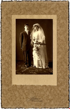
William and Sarah Parker
https://search.heritageburnaby.ca/link/museumdescription16711
- Repository
- Burnaby Village Museum
- Date
- 20 Aug. 1913
- Collection/Fonds
- Love family fonds
- Description Level
- Item
- Physical Description
- 1 photograph : sepia ; 14 x 9.5 cm mounted on mat 27.5 x 17 cm
- Scope and Content
- Photograph wedding portrait of William Parker and Sarah Parker (nee Love). The couple were married at St. Alban's Church in Burnaby, August 20, 1913.
- Repository
- Burnaby Village Museum
- Collection/Fonds
- Love family fonds
- Description Level
- Item
- Physical Description
- 1 photograph : sepia ; 14 x 9.5 cm mounted on mat 27.5 x 17 cm
- Scope and Content
- Photograph wedding portrait of William Parker and Sarah Parker (nee Love). The couple were married at St. Alban's Church in Burnaby, August 20, 1913.
- Subjects
- Ceremonies - Weddings
- Accession Code
- BV008.20.4
- Access Restriction
- No restrictions
- Reproduction Restriction
- No known restrictions
- Date
- 20 Aug. 1913
- Media Type
- Photograph
- Scan Resolution
- 600
- Scan Date
- June 14, 2021
- Scale
- 100
- Photographer
- Ritchie, Samuel J.
- Notes
- Title based on content of photograph
- Embossed label on matt reads: "Ritchie / New Westminster B.C."
Images

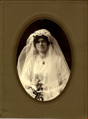
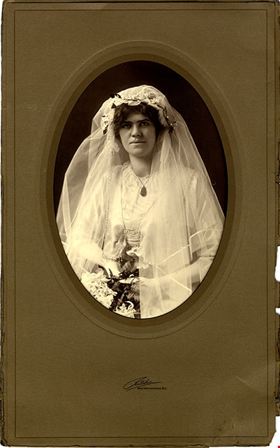
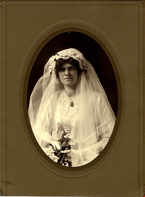
Sarah Love Parker
https://search.heritageburnaby.ca/link/museumdescription16712
- Repository
- Burnaby Village Museum
- Date
- 20 Aug. 1913
- Collection/Fonds
- Love family fonds
- Description Level
- Item
- Physical Description
- 1 photograph : sepia ; 25 x 20 cm in mat 34.5 x 25.5 with 24 x 16 cm (oval, sight)
- Scope and Content
- Photograph of bride, Sarah Parker (nee Love) on her wedding day. Sarah Love married William Micheal Parker at St. Alban's Church in Burnaby, August 20, 1913.
- Repository
- Burnaby Village Museum
- Collection/Fonds
- Love family fonds
- Description Level
- Item
- Physical Description
- 1 photograph : sepia ; 25 x 20 cm in mat 34.5 x 25.5 with 24 x 16 cm (oval, sight)
- Scope and Content
- Photograph of bride, Sarah Parker (nee Love) on her wedding day. Sarah Love married William Micheal Parker at St. Alban's Church in Burnaby, August 20, 1913.
- Subjects
- Ceremonies - Weddings
- Names
- Parker, Sarah Maria Love
- Accession Code
- BV008.20.5
- Access Restriction
- No restrictions
- Reproduction Restriction
- No known restrictions
- Date
- 20 Aug. 1913
- Media Type
- Photograph
- Scan Resolution
- 600
- Scan Date
- June 14, 2021
- Scale
- 100
- Photographer
- Ritchie, Samuel J.
- Notes
- Title based on content of photograph
- Embossed label on matt reads: "Ritchie / New Westminster B.C."
Images
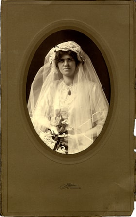
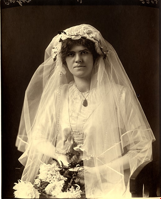
Wedding portrait of Sarah Love Parker
https://search.heritageburnaby.ca/link/museumdescription18828
- Repository
- Burnaby Village Museum
- Date
- 20 Aug 1913
- Collection/Fonds
- Love family fonds
- Description Level
- Item
- Physical Description
- 1 photograph : sepia ; 25 x 20 cm in mat 41.5 x 25 with 24 x 16.5 cm (oval, sight)
- Scope and Content
- Photograph portrait of Sarah Love Parker in her wedding dress on her wedding day. Sarah Love married William Micheal Parker at St. Alban's Church in Burnaby, August 20, 1913.
- Repository
- Burnaby Village Museum
- Collection/Fonds
- Love family fonds
- Description Level
- Item
- Physical Description
- 1 photograph : sepia ; 25 x 20 cm in mat 41.5 x 25 with 24 x 16.5 cm (oval, sight)
- Material Details
- Photograph removed from mat
- Scope and Content
- Photograph portrait of Sarah Love Parker in her wedding dress on her wedding day. Sarah Love married William Micheal Parker at St. Alban's Church in Burnaby, August 20, 1913.
- Subjects
- Ceremonies - Weddings
- Names
- Parker, Sarah Maria Love
- Accession Code
- BV019.8.14
- Access Restriction
- No restrictions
- Reproduction Restriction
- No known restrictions
- Date
- 20 Aug 1913
- Media Type
- Photograph
- Scan Resolution
- 600
- Scan Date
- 2022-07-07
- Photographer
- Ritchie, Samuel J.
- Notes
- Title based on contents of photograph
- Mat is embossed with photographer: "Ritchie / New Westminster, B.C."
Images