Narrow Results By
Subject
- Accidents - Automobile Accidents 2
- Animals - Dogs 1
- Buildings - Industrial - Factories 1
- Buildings - Residential - Cabins 2
- Buildings - Residential - Houses 19
- Construction 1
- Construction - Road Construction 4
- Geographic Features - Beaches 1
- Geographic Features - Creeks 1
- Geographic Features - Inlets 1
- Geographic Features - Mountains 2
- Geographic Features - Neighbourhoods 1
![311 Madison Avenue, [1949 or 1950] (date of original), copied 1991 thumbnail](/media/hpo/_Data/_Archives_Images/_Unrestricted/370/370-204.jpg?width=280)
311 Madison Avenue
https://search.heritageburnaby.ca/link/archivedescription37616
- Repository
- City of Burnaby Archives
- Date
- [1949 or 1950] (date of original), copied 1991
- Collection/Fonds
- Burnaby Historical Society fonds
- Description Level
- Item
- Physical Description
- 1 photograph : b&w ; 3.0 x 4.5 cm print on contact sheet 20.2 x 25.3 cm
- Scope and Content
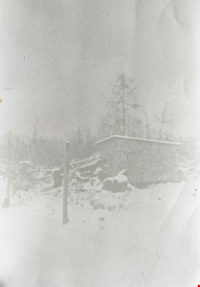
- Photograph of a side view of 311 Madison Avenue, in the snow. The photograph was taken from Madison Avenue.
- Repository
- City of Burnaby Archives
- Date
- [1949 or 1950] (date of original), copied 1991
- Collection/Fonds
- Burnaby Historical Society fonds
- Subseries
- Burnaby Image Bank subseries
- Physical Description
- 1 photograph : b&w ; 3.0 x 4.5 cm print on contact sheet 20.2 x 25.3 cm
- Description Level
- Item
- Record No.
- 370-204
- Access Restriction
- No restrictions
- Reproduction Restriction
- No restrictions
- Accession Number
- BHS1999-03
- Scope and Content
- Photograph of a side view of 311 Madison Avenue, in the snow. The photograph was taken from Madison Avenue.
- Media Type
- Photograph
- Notes
- Title based on contents of photograph
- 1 b&w copy negative accompanying
- Geographic Access
- Madison Avenue
- Street Address
- 311 Madison Avenue
- Historic Neighbourhood
- Vancouver Heights (Historic Neighbourhood)
- Planning Study Area
- Burnaby Heights Area
Images
![311 Madison Avenue, [1949 or 1950] (date of original), copied 1991 thumbnail](/media/hpo/_Data/_Archives_Images/_Unrestricted/370/370-204.jpg)
![1000 Block Gilley Avenue, [1955] (date of original), copied 1991 thumbnail](/media/hpo/_Data/_Archives_Images/_Unrestricted/370/370-672.jpg?width=280)
1000 Block Gilley Avenue
https://search.heritageburnaby.ca/link/archivedescription38085
- Repository
- City of Burnaby Archives
- Date
- [1955] (date of original), copied 1991
- Collection/Fonds
- Burnaby Historical Society fonds
- Description Level
- Item
- Physical Description
- 1 photograph : b&w ; 3.1 x 3.0 cm print on contact sheet 21.5 x 26.8 cm
- Scope and Content
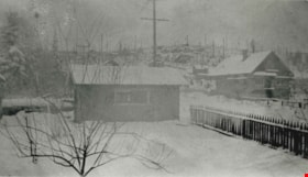
- Photograph of the 1000 block of Gilley Avenue (later renumbered the 8000 block) looking south towards Marine Drive in the snow.
- Repository
- City of Burnaby Archives
- Date
- [1955] (date of original), copied 1991
- Collection/Fonds
- Burnaby Historical Society fonds
- Subseries
- Burnaby Image Bank subseries
- Physical Description
- 1 photograph : b&w ; 3.1 x 3.0 cm print on contact sheet 21.5 x 26.8 cm
- Description Level
- Item
- Record No.
- 370-672
- Access Restriction
- No restrictions
- Reproduction Restriction
- No restrictions
- Accession Number
- BHS1999-03
- Scope and Content
- Photograph of the 1000 block of Gilley Avenue (later renumbered the 8000 block) looking south towards Marine Drive in the snow.
- Media Type
- Photograph
- Notes
- Title based on contents of photograph
- 1 b&w copy negative accompanying
- Negative has a pink cast
- Geographic Access
- Gilley Avenue
- Planning Study Area
- Clinton-Glenwood Area
- Stride Hill Area
Images
![1000 Block Gilley Avenue, [1955] (date of original), copied 1991 thumbnail](/media/hpo/_Data/_Archives_Images/_Unrestricted/370/370-672.jpg)
![4674 Southlawn Drive, [1958] (date of original), copied 1991 thumbnail](/media/hpo/_Data/_Archives_Images/_Unrestricted/370/370-461.jpg?width=280)
4674 Southlawn Drive
https://search.heritageburnaby.ca/link/archivedescription37873
- Repository
- City of Burnaby Archives
- Date
- [1958] (date of original), copied 1991
- Collection/Fonds
- Burnaby Historical Society fonds
- Description Level
- Item
- Physical Description
- 1 photograph : b&w ; 2.8 x 2.8 cm print on contact sheet 20.1 x 26.7 cm
- Scope and Content
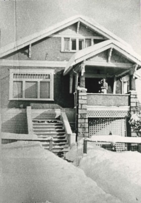
- Photograph of 4674 Southlawn Drive in the snow. The snow-covered road can be seen in front of the house.
- Repository
- City of Burnaby Archives
- Date
- [1958] (date of original), copied 1991
- Collection/Fonds
- Burnaby Historical Society fonds
- Subseries
- Burnaby Image Bank subseries
- Physical Description
- 1 photograph : b&w ; 2.8 x 2.8 cm print on contact sheet 20.1 x 26.7 cm
- Description Level
- Item
- Record No.
- 370-461
- Access Restriction
- No restrictions
- Reproduction Restriction
- No restrictions
- Accession Number
- BHS1999-03
- Scope and Content
- Photograph of 4674 Southlawn Drive in the snow. The snow-covered road can be seen in front of the house.
- Media Type
- Photograph
- Notes
- Title based on contents of photograph
- 1 b&w copy negative accompanying
- Negative has a pink cast
- Geographic Access
- Southlawn Drive
- Street Address
- 4674 Southlawn Drive
- Planning Study Area
- Brentwood Area
Images
![4674 Southlawn Drive, [1958] (date of original), copied 1991 thumbnail](/media/hpo/_Data/_Archives_Images/_Unrestricted/370/370-461.jpg)
![5987 Malvern Avenue during snowfall, [1958 or 1959] (date of original), copied 1991 thumbnail](/media/hpo/_Data/_Archives_Images/_Unrestricted/370/370-170.jpg?width=280)
5987 Malvern Avenue during snowfall
https://search.heritageburnaby.ca/link/archivedescription37582
- Repository
- City of Burnaby Archives
- Date
- [1958 or 1959] (date of original), copied 1991
- Collection/Fonds
- Burnaby Historical Society fonds
- Description Level
- Item
- Physical Description
- 1 photograph : b&w ; 3.1 x 4.6 cm print on contact sheet 20.2 x 25.3 cm
- Scope and Content
- Photograph of the front of 5987 Malvern Avenue during a heavy snowfall. Someone is standing outside the house under an umbrella.
- Repository
- City of Burnaby Archives
- Date
- [1958 or 1959] (date of original), copied 1991
- Collection/Fonds
- Burnaby Historical Society fonds
- Subseries
- Burnaby Image Bank subseries
- Physical Description
- 1 photograph : b&w ; 3.1 x 4.6 cm print on contact sheet 20.2 x 25.3 cm
- Description Level
- Item
- Record No.
- 370-170
- Access Restriction
- No restrictions
- Reproduction Restriction
- No restrictions
- Accession Number
- BHS1999-03
- Scope and Content
- Photograph of the front of 5987 Malvern Avenue during a heavy snowfall. Someone is standing outside the house under an umbrella.
- Media Type
- Photograph
- Notes
- Title based on contents of photograph
- 1 b&w copy negative accompanying
- Negative has a pink cast
- Geographic Access
- Malvern Avenue
- Street Address
- 5987 Malvern Avenue
- Historic Neighbourhood
- Burnaby Lake (Historic Neighbourhood)
- Planning Study Area
- Morley-Buckingham Area
Images
![5987 Malvern Avenue during snowfall, [1958 or 1959] (date of original), copied 1991 thumbnail](/media/hpo/_Data/_Archives_Images/_Unrestricted/370/370-170.jpg)
![Allanson family home, [192-] (date of original), copied 1986 thumbnail](/media/hpo/_Data/_Archives_Images/_Unrestricted/204/204-652.jpg?width=280)
Allanson family home
https://search.heritageburnaby.ca/link/archivedescription35794
- Repository
- City of Burnaby Archives
- Date
- [192-] (date of original), copied 1986
- Collection/Fonds
- Burnaby Historical Society fonds
- Description Level
- Item
- Physical Description
- 1 photograph : b&w ; 12.7 x 17.8 cm print
- Scope and Content
- Photograph of the Allanson family home, 12 Warwick Avenue, Capitol Hill, North Burnaby.
- Repository
- City of Burnaby Archives
- Date
- [192-] (date of original), copied 1986
- Collection/Fonds
- Burnaby Historical Society fonds
- Subseries
- Pioneer Tales subseries
- Physical Description
- 1 photograph : b&w ; 12.7 x 17.8 cm print
- Description Level
- Item
- Record No.
- 204-652
- Access Restriction
- No restrictions
- Reproduction Restriction
- No known restrictions
- Accession Number
- BHS1988-03
- Scope and Content
- Photograph of the Allanson family home, 12 Warwick Avenue, Capitol Hill, North Burnaby.
- Media Type
- Photograph
- Notes
- Title based on contents of photograph
- Geographic Access
- Warwick Avenue
- Street Address
- 12 Warwick Avenue
- Historic Neighbourhood
- Capitol Hill (Historic Neighbourhood)
- Planning Study Area
- Capitol Hill Area
Images
![Allanson family home, [192-] (date of original), copied 1986 thumbnail](/media/hpo/_Data/_Archives_Images/_Unrestricted/204/204-652.jpg)
![Automobile accident, [after 1924] thumbnail](/media/hpo/_Data/_BVM_Images/1990/199900550048.jpg?width=280)
Automobile accident
https://search.heritageburnaby.ca/link/museumdescription1499
- Repository
- Burnaby Village Museum
- Date
- [after 1924]
- Collection/Fonds
- Burnaby Village Museum Photograph collection
- Description Level
- Item
- Physical Description
- 1 photograph : sepia ; 7.5 x 5.5 cm
- Scope and Content
- Photograph of a Dodge coupe with its front end in an icy, snow covered ditch, and the rest of the body hanging on the slope.
- Repository
- Burnaby Village Museum
- Collection/Fonds
- Burnaby Village Museum Photograph collection
- Description Level
- Item
- Physical Description
- 1 photograph : sepia ; 7.5 x 5.5 cm
- Scope and Content
- Photograph of a Dodge coupe with its front end in an icy, snow covered ditch, and the rest of the body hanging on the slope.
- Accession Code
- BV999.55.48
- Access Restriction
- No restrictions
- Date
- [after 1924]
- Media Type
- Photograph
- Related Material
- For other photographs depicting the retrieval of a damaged car in snow, see BV999.55.47 - .49 They may be of the same or related events.
- Scan Resolution
- 600
- Scan Date
- 09-Jun-09
- Scale
- 100
- Notes
- Title based on contents of photograph
Images
![Automobile accident, [after 1924] thumbnail](/media/hpo/_Data/_BVM_Images/1990/199900550048.jpg)
![Back yard of 5118 Douglas Road, [1951] thumbnail](/media/hpo/_Data/_Archives_Images/_Unrestricted/600/620-019.jpg?width=280)
Back yard of 5118 Douglas Road
https://search.heritageburnaby.ca/link/archivedescription91838
- Repository
- City of Burnaby Archives
- Date
- [1951]
- Collection/Fonds
- Small family fonds
- Description Level
- Item
- Physical Description
- 1 photograph : b&w ; 7 cm x 11.5 cm
- Scope and Content
- Photograph of the backyard and screened summer house at 5118 Douglas Road after a snowfall. The summer house was used by the Roberts children for sleeping outdoors in the summertime and by the Small children as a playhouse. It rotted and collapsed in the 1960s, likely following the "Big Snow" of …
- Repository
- City of Burnaby Archives
- Date
- [1951]
- Collection/Fonds
- Small family fonds
- Physical Description
- 1 photograph : b&w ; 7 cm x 11.5 cm
- Description Level
- Item
- Record No.
- 620-019
- Access Restriction
- No restrictions
- Reproduction Restriction
- No reproduction permitted
- Accession Number
- 2017-01
- Scope and Content
- Photograph of the backyard and screened summer house at 5118 Douglas Road after a snowfall. The summer house was used by the Roberts children for sleeping outdoors in the summertime and by the Small children as a playhouse. It rotted and collapsed in the 1960s, likely following the "Big Snow" of December 1964.
- Media Type
- Photograph
- Notes
- Transcribed title
- Title transcribed from donor's notes
- Note in black ink on verso of photograph reads: "Summer House in the Snow / Burnaby - 1951?"
- Note in blue ink on verson of photograph reads: "P.19"
- 5118 Douglas Road renumbered to 3131 Douglas Road in 1958 and to 5538 Dominion Street in 1970 or 1971
- Street Address
- 3131 Douglas Road
- 5118 Douglas Road
- 5538 Dominion Street
- Historic Neighbourhood
- Burnaby Lake (Historic Neighbourhood)
- Planning Study Area
- Ardingley-Sprott Area
Images
![Back yard of 5118 Douglas Road, [1951] thumbnail](/media/hpo/_Data/_Archives_Images/_Unrestricted/600/620-019.jpg)

Barnet Road
https://search.heritageburnaby.ca/link/archivedescription35635
- Repository
- City of Burnaby Archives
- Date
- 1921 (date of original), copied 1986
- Collection/Fonds
- Burnaby Historical Society fonds
- Description Level
- Item
- Physical Description
- 1 photograph : b&w ; 12.7 x 17.8 cm print
- Scope and Content
- Photograph of Barnet Road covered with November snows. The road was always treacherous in winter with snow and rock slides. In the upper right corner of the photograph is Barnet School and caretaker's cottage. Barnet School was located at 7820 Barnet Road.
- Repository
- City of Burnaby Archives
- Date
- 1921 (date of original), copied 1986
- Collection/Fonds
- Burnaby Historical Society fonds
- Subseries
- Pioneer Tales subseries
- Physical Description
- 1 photograph : b&w ; 12.7 x 17.8 cm print
- Description Level
- Item
- Record No.
- 204-493
- Access Restriction
- No restrictions
- Reproduction Restriction
- No known restrictions
- Accession Number
- BHS1988-03
- Scope and Content
- Photograph of Barnet Road covered with November snows. The road was always treacherous in winter with snow and rock slides. In the upper right corner of the photograph is Barnet School and caretaker's cottage. Barnet School was located at 7820 Barnet Road.
- Names
- Barnet School
- Media Type
- Photograph
- Notes
- Title based on contents of photograph
- Geographic Access
- Barnet Road
- Street Address
- 7820 Barnet Road
- Historic Neighbourhood
- Barnet (Historic Neighbourhood)
- Planning Study Area
- Burnaby Mountain Area
Images

B.C. Electric Railway tram no. 1306 on Central Park Line
https://search.heritageburnaby.ca/link/museumdescription2902
- Repository
- Burnaby Village Museum
- Date
- 1952
- Collection/Fonds
- Burnaby Village Museum Photograph collection
- Description Level
- Item
- Physical Description
- 1 photograph : b&w ; 9 x 13 cm
- Scope and Content
- Phototgraph of B.C. Electric Railway tram no. 1306 running on the tracks between Earles Road and Collingwood west on the Central Park Line. The ground is covered with snow.
- Repository
- Burnaby Village Museum
- Collection/Fonds
- Burnaby Village Museum Photograph collection
- Description Level
- Item
- Physical Description
- 1 photograph : b&w ; 9 x 13 cm
- Scope and Content
- Phototgraph of B.C. Electric Railway tram no. 1306 running on the tracks between Earles Road and Collingwood west on the Central Park Line. The ground is covered with snow.
- Accession Code
- BV012.36.10
- Access Restriction
- No restrictions
- Reproduction Restriction
- No known restrictions
- Date
- 1952
- Media Type
- Photograph
- Scan Resolution
- 600
- Scan Date
- 2022-07-26
- Notes
- Title based on contents of photograph
- "Khulman built BCER #1306 / running between Earles Road and Collingwood / west on Central Park Line 1952 / Earles Road substation in background"
Images

B.C. Electric Railway tram no. 1309 tram on Central Park Line
https://search.heritageburnaby.ca/link/museumdescription2896
- Repository
- Burnaby Village Museum
- Date
- 1953
- Collection/Fonds
- Burnaby Village Museum Photograph collection
- Description Level
- Item
- Physical Description
- 1 photograph : b&w ; 9 x 13 cm
- Scope and Content
- Photograph of B.C. Electric Railway tram no. 1309 travelling along the Central Park Line westbound to Vancouver between Collingwood West and Earls Road after a winter storm. The tracks and hillside are covered with snow.
- Repository
- Burnaby Village Museum
- Collection/Fonds
- Burnaby Village Museum Photograph collection
- Description Level
- Item
- Physical Description
- 1 photograph : b&w ; 9 x 13 cm
- Scope and Content
- Photograph of B.C. Electric Railway tram no. 1309 travelling along the Central Park Line westbound to Vancouver between Collingwood West and Earls Road after a winter storm. The tracks and hillside are covered with snow.
- Accession Code
- BV012.36.4
- Access Restriction
- No restrictions
- Reproduction Restriction
- No known restrictions
- Date
- 1953
- Media Type
- Photograph
- Scan Resolution
- 600
- Scan Date
- 2022-07-26
- Notes
- Title based on contents of photograph
- Typewritten text on verso of photograph reads: "Home built B.C.E.R. #1309 hurries along / Central Park line westbound to Vancovuer / between Collingwood West and Earls Road / after a winter snow storm in 1953"
Images


Bea Mengel, Sandy Matheson and Pat Loynes
https://search.heritageburnaby.ca/link/archivedescription37669
- Repository
- City of Burnaby Archives
- Date
- 1954 (date of original), copied 1991
- Collection/Fonds
- Burnaby Historical Society fonds
- Description Level
- Item
- Physical Description
- 1 photograph : b&w ; 3.1 x 4.6 cm print on contact sheet 20.2 x 25.3 cm
- Scope and Content
- Photograph of a woman and two children in the snow on the 6100 block of Kathleen Avenue. Clockwise from top: Bea Mengel, Sandy Matheson, and Pat Loynes.
- Repository
- City of Burnaby Archives
- Date
- 1954 (date of original), copied 1991
- Collection/Fonds
- Burnaby Historical Society fonds
- Subseries
- Burnaby Image Bank subseries
- Physical Description
- 1 photograph : b&w ; 3.1 x 4.6 cm print on contact sheet 20.2 x 25.3 cm
- Description Level
- Item
- Record No.
- 370-257
- Access Restriction
- No restrictions
- Reproduction Restriction
- No restrictions
- Accession Number
- BHS1999-03
- Scope and Content
- Photograph of a woman and two children in the snow on the 6100 block of Kathleen Avenue. Clockwise from top: Bea Mengel, Sandy Matheson, and Pat Loynes.
- Subjects
- Natural Phenomena - Snow
- Media Type
- Photograph
- Notes
- Title based on contents of photograph
- 1 b&w copy negative accompanying
- Negative has a pink cast
- Geographic Access
- Kathleen Avenue
- Historic Neighbourhood
- Central Park (Historic Neighbourhood)
- Planning Study Area
- Maywood Area
Images
Boberg family home
https://search.heritageburnaby.ca/link/archivedescription35771
- Repository
- City of Burnaby Archives
- Date
- 1922 (date of original), copied 1986
- Collection/Fonds
- Burnaby Historical Society fonds
- Description Level
- Item
- Physical Description
- 1 photograph : b&w ; 12.7 x 17.8 cm print
- Scope and Content
- Photograph of the first Boberg family home after a heavy snowfall, on Douglas Road in the Still Creek lowlands where the creek flows into Burnaby Lake. The Bobergs moved here in 1920.
- Repository
- City of Burnaby Archives
- Date
- 1922 (date of original), copied 1986
- Collection/Fonds
- Burnaby Historical Society fonds
- Subseries
- Pioneer Tales subseries
- Physical Description
- 1 photograph : b&w ; 12.7 x 17.8 cm print
- Description Level
- Item
- Record No.
- 204-629
- Access Restriction
- No restrictions
- Reproduction Restriction
- No known restrictions
- Accession Number
- BHS1988-03
- Scope and Content
- Photograph of the first Boberg family home after a heavy snowfall, on Douglas Road in the Still Creek lowlands where the creek flows into Burnaby Lake. The Bobergs moved here in 1920.
- Media Type
- Photograph
- Notes
- Title based on contents of photograph
- Historic Neighbourhood
- Burnaby Lake (Historic Neighbourhood)
- Planning Study Area
- Ardingley-Sprott Area
Images

![Bob Peers shovelling snow, [1929] thumbnail](/media/hpo/_Data/_Archives_Images/_Unrestricted/477/477-318.jpg?width=280)
Bob Peers shovelling snow
https://search.heritageburnaby.ca/link/archivedescription38999
- Repository
- City of Burnaby Archives
- Date
- [1929]
- Collection/Fonds
- Peers Family and Hill Family fonds
- Description Level
- Item
- Physical Description
- 1 photograph : b&w ; 6 x 10.5 cm on page 13.5 x 18.5 cm (pasted in album)
- Scope and Content
- Photograph of Bob Peers shovelling snow outside of house. His son Robert is standing to the right, wearing winter coat and hat. This photograph was likely taken at the home of Claude and Annie Hill, parents of Bob's wife Kitty.
- Repository
- City of Burnaby Archives
- Date
- [1929]
- Collection/Fonds
- Peers Family and Hill Family fonds
- Physical Description
- 1 photograph : b&w ; 6 x 10.5 cm on page 13.5 x 18.5 cm (pasted in album)
- Description Level
- Item
- Record No.
- 477-318
- Access Restriction
- No restrictions
- Reproduction Restriction
- No known restrictions
- Accession Number
- 2007-12
- Scope and Content
- Photograph of Bob Peers shovelling snow outside of house. His son Robert is standing to the right, wearing winter coat and hat. This photograph was likely taken at the home of Claude and Annie Hill, parents of Bob's wife Kitty.
- Media Type
- Photograph
- Notes
- Title based on contents of photograph
- Geographic Access
- Deer Lake Avenue
- Street Address
- 6570 Deer Lake Avenue
- Historic Neighbourhood
- Burnaby Lake (Historic Neighbourhood)
- Planning Study Area
- Douglas-Gilpin Area
Images
![Bob Peers shovelling snow, [1929] thumbnail](/media/hpo/_Data/_Archives_Images/_Unrestricted/477/477-318.jpg)

Bridge over a frozen river
https://search.heritageburnaby.ca/link/archivedescription34449
- Repository
- City of Burnaby Archives
- Date
- 1925
- Collection/Fonds
- Burnaby Historical Society fonds
- Description Level
- Item
- Physical Description
- 1 photograph : sepia ; 6.1 x 11.8 cm
- Scope and Content
- Photograph of a railroad bridge spanning a river that has frozen over.
- Repository
- City of Burnaby Archives
- Date
- 1925
- Collection/Fonds
- Burnaby Historical Society fonds
- Subseries
- Peers family subseries
- Physical Description
- 1 photograph : sepia ; 6.1 x 11.8 cm
- Description Level
- Item
- Record No.
- 020-156
- Access Restriction
- No restrictions
- Reproduction Restriction
- No known restrictions
- Accession Number
- BHS2007-04
- Scope and Content
- Photograph of a railroad bridge spanning a river that has frozen over.
- Subjects
- Structures - Bridges
- Transportation - Rail
- Natural Phenomena - Snow
- Geographic Features - Rivers
- Media Type
- Photograph
- Notes
- Title based on contents of photograph
Images


Bridge over Deer Lake Brook
https://search.heritageburnaby.ca/link/archivedescription39323
- Repository
- City of Burnaby Archives
- Date
- 1922
- Collection/Fonds
- Peers Family and Hill Family fonds
- Description Level
- Item
- Physical Description
- 1 photograph : b&w ; 6.2 x 9.8 cm on page 24.5 x 32.5 cm (pasted in album)
- Scope and Content
- Photograph of a bridge over Deer Lake Brook, covered with snow. This photograph was probably taken on the property belonging to Claude Hill, known as "Brookfield."
- Repository
- City of Burnaby Archives
- Date
- 1922
- Collection/Fonds
- Peers Family and Hill Family fonds
- Physical Description
- 1 photograph : b&w ; 6.2 x 9.8 cm on page 24.5 x 32.5 cm (pasted in album)
- Description Level
- Item
- Record No.
- 477-642
- Access Restriction
- No restrictions
- Reproduction Restriction
- No known restrictions
- Accession Number
- 2007-12
- Scope and Content
- Photograph of a bridge over Deer Lake Brook, covered with snow. This photograph was probably taken on the property belonging to Claude Hill, known as "Brookfield."
- Media Type
- Photograph
- Notes
- Title based on contents of photograph
- Geographic Access
- Deer Lake Brook
- Deer Lake Avenue
- Street Address
- 6501 Deer Lake Avenue
- Historic Neighbourhood
- Burnaby Lake (Historic Neighbourhood)
- Planning Study Area
- Morley-Buckingham Area
Images

![Broadview district covered in snow, [192-?] (date of original), copied 1992 thumbnail](/media/hpo/_Data/_Archives_Images/_Unrestricted/315/315-490.jpg?width=280)
Broadview district covered in snow
https://search.heritageburnaby.ca/link/archivedescription37027
- Repository
- City of Burnaby Archives
- Date
- [192-?] (date of original), copied 1992
- Collection/Fonds
- Burnaby Historical Society fonds
- Description Level
- Item
- Physical Description
- 1 photograph : b&w ; 10.1 x 14.9 cm print
- Scope and Content
- Photograph the Broadview district covered in snow. Annotation under photograph reads, "Backyard of Roma's [Richards] House / House in background is Alex Smith's"
- Repository
- City of Burnaby Archives
- Date
- [192-?] (date of original), copied 1992
- Collection/Fonds
- Burnaby Historical Society fonds
- Subseries
- Burnaby Centennial Anthology subseries
- Physical Description
- 1 photograph : b&w ; 10.1 x 14.9 cm print
- Description Level
- Item
- Record No.
- 315-490
- Access Restriction
- No restrictions
- Reproduction Restriction
- No known restrictions
- Accession Number
- BHS1994-04
- Scope and Content
- Photograph the Broadview district covered in snow. Annotation under photograph reads, "Backyard of Roma's [Richards] House / House in background is Alex Smith's"
- Subjects
- Natural Phenomena - Snow
- Media Type
- Photograph
- Notes
- Title based on contents of photograph
- Historic Neighbourhood
- Broadview (Historic Neighbourhood)
Images
![Broadview district covered in snow, [192-?] (date of original), copied 1992 thumbnail](/media/hpo/_Data/_Archives_Images/_Unrestricted/315/315-490.jpg)
![Burrard Inlet in winter, [192-] thumbnail](/media/hpo/_Data/_BVM_Images/2007/2007_0045_0017_001.jpg?width=280)
Burrard Inlet in winter
https://search.heritageburnaby.ca/link/museumdescription3902
- Repository
- Burnaby Village Museum
- Date
- [192-]
- Collection/Fonds
- Burnaby Village Museum Photograph collection
- Description Level
- Item
- Physical Description
- 1 photograph : b&w ; 26.5 x 16 cm
- Scope and Content
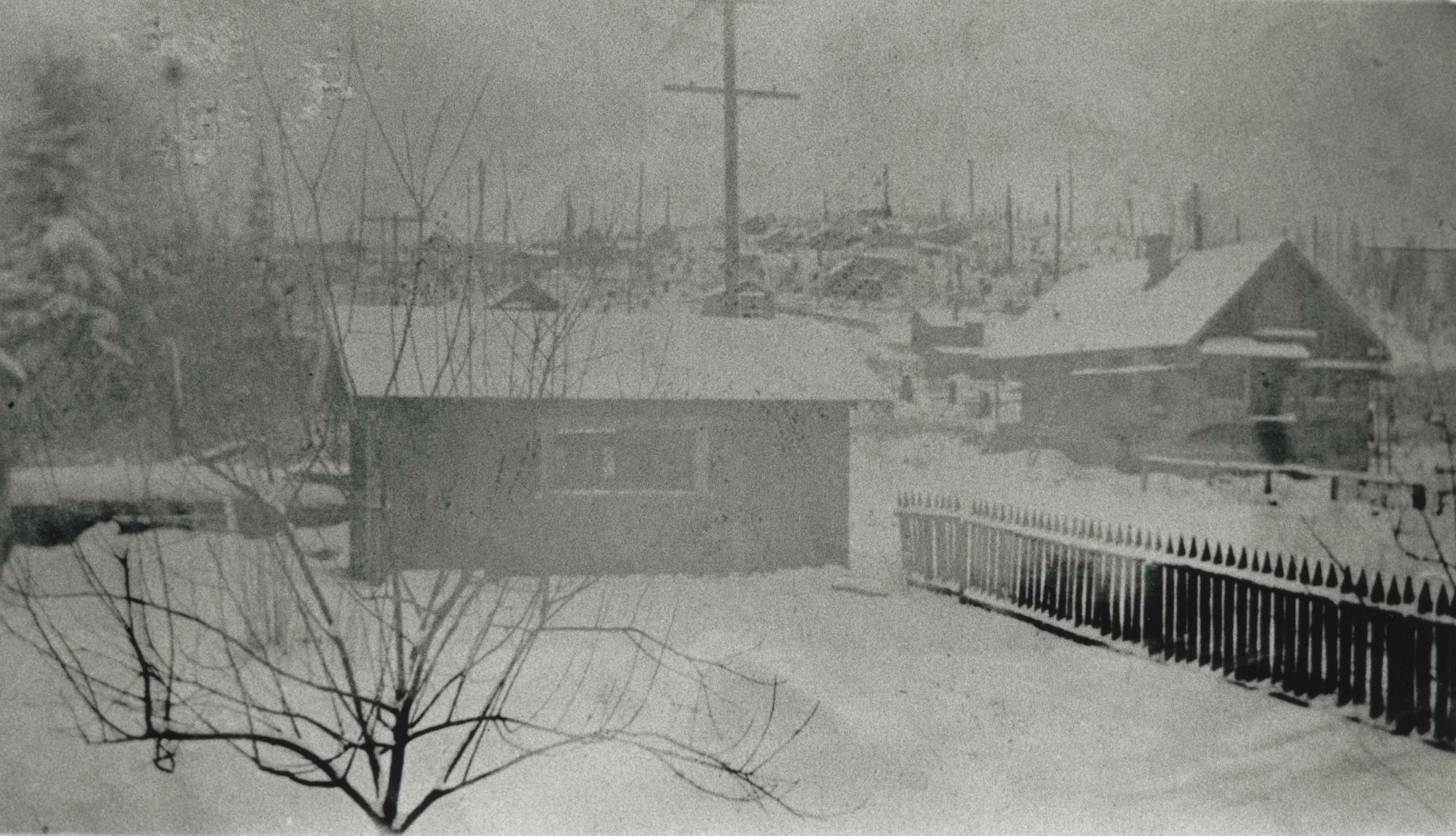
- Photograph of a Vancouver Heights streetscape in winter. There is snow on the ground. One of the houses across the street has what appears to be a radio mast in the front yard. The photograph is taken looking Northeast toward the Burrard Inlet with Mount Seymour in the background.
- Repository
- Burnaby Village Museum
- Collection/Fonds
- Burnaby Village Museum Photograph collection
- Description Level
- Item
- Physical Description
- 1 photograph : b&w ; 26.5 x 16 cm
- Material Details
- "Burrard Inlet - winter" written in ink on back of photo. "37" written in pencil on back of photo.
- Scope and Content
- Photograph of a Vancouver Heights streetscape in winter. There is snow on the ground. One of the houses across the street has what appears to be a radio mast in the front yard. The photograph is taken looking Northeast toward the Burrard Inlet with Mount Seymour in the background.
- History
- George Vincent Martin was born in 1892 in England. He married Matilda Florence Reed in 1916. He purchased a property in North Burnaby in the 1920s on Trinity Street. There was a main house and a "shack" on the property split up onto two lots.
- Subjects
- Natural Phenomena - Snow
- Geographic Features - Mountains
- Geographic Features - Inlets
- Buildings - Residential - Houses
- Accession Code
- BV007.45.17
- Access Restriction
- No restrictions
- Reproduction Restriction
- No known restrictions
- Date
- [192-]
- Media Type
- Photograph
- Scan Resolution
- 300
- Scan Date
- 29-Nov-2018
- Scale
- 96
- Notes
- Title based on content of the photograph
Images
![Burrard Inlet in winter, [192-] thumbnail](/media/hpo/_Data/_BVM_Images/2007/2007_0045_0017_001.jpg)
Butler family home
https://search.heritageburnaby.ca/link/archivedescription35477
- Repository
- City of Burnaby Archives
- Date
- 1928 (date of original), copied 1986
- Collection/Fonds
- Burnaby Historical Society fonds
- Description Level
- Item
- Physical Description
- 1 photograph : b&w ; 12.7 x 17.8 cm print
- Scope and Content
- Photograph of the Butler family home at 7790 Buller Avenue in the snow. This was the home of Edwin Butler, his wife Margaret Butler, and their children.
- Repository
- City of Burnaby Archives
- Date
- 1928 (date of original), copied 1986
- Collection/Fonds
- Burnaby Historical Society fonds
- Subseries
- Pioneer Tales subseries
- Physical Description
- 1 photograph : b&w ; 12.7 x 17.8 cm print
- Description Level
- Item
- Record No.
- 204-335
- Access Restriction
- No restrictions
- Reproduction Restriction
- No known restrictions
- Accession Number
- BHS1988-03
- Scope and Content
- Photograph of the Butler family home at 7790 Buller Avenue in the snow. This was the home of Edwin Butler, his wife Margaret Butler, and their children.
- Media Type
- Photograph
- Notes
- Title based on contents of photograph
- Geographic Access
- Buller Avenue
- Street Address
- 7790 Buller Avenue
- Historic Neighbourhood
- Alta-Vista (Historic Neighbourhood)
- Planning Study Area
- Clinton-Glenwood Area
Images

Campsite Collection
https://search.heritageburnaby.ca/link/museumdescription4589
- Repository
- Burnaby Village Museum
- Date
- [between 1958 and 2002]
- Collection/Fonds
- Burnaby Girl Guides fonds
- Description Level
- File
- Physical Description
- 1 file : 33 photographs + textual records + other material
- Scope and Content
- File consists of photographs, an illustration, ephemera and histories about Burnaby Guiding Camps including Burnaby Chalet on Cypress Mountain, Galalina Camp at Camp Olave near Sechelt B.C., Burnaby Guide Camp at Wilson Creek and a few postcards of Camp Tsoona, Rosedale B.C. A collection of written…
- Repository
- Burnaby Village Museum
- Collection/Fonds
- Burnaby Girl Guides fonds
- Description Level
- File
- Physical Description
- 1 file : 33 photographs + textual records + other material
- Scope and Content
- File consists of photographs, an illustration, ephemera and histories about Burnaby Guiding Camps including Burnaby Chalet on Cypress Mountain, Galalina Camp at Camp Olave near Sechelt B.C., Burnaby Guide Camp at Wilson Creek and a few postcards of Camp Tsoona, Rosedale B.C. A collection of written material provides historical background regarding the two storey cabin on Hollyburn Mountain. The cabin was purchased by Burnaby Girl Guides in 1964 and appropriately named Burnaby Chalet. A Chalet Committee was formed with representatives from each Division appointing a Chalet Manageress to handle reservations. This typical ski cabin can accomodate up to 40 people. The file also includes a "Campsite Log Book" for the Hollyburn Chalet with handwritten notes from 1981 and 1982, an embroidered triangular shaped badge "Burnaby Royal / Girl Guides / Hollyburn Chalet" and a dedication ceremony program for "Burnaby Guide Camp / June 8, 1958" (Wilson Creek).
- Subjects
- Organizations - Girls' Societies and Clubs
- Recreational Activities - Camping
- Natural Phenomena - Snow
- Geographic Features - Beaches
- Names
- Girl Guides of Canada
- Accession Code
- BV015.35.161
- Access Restriction
- No restrictions
- Reproduction Restriction
- May be restricted by third party rights
- Date
- [between 1958 and 2002]
- Media Type
- Photograph
- Textual Record
- Notes
- Transcribed title
Capitol Hill neighborhood
https://search.heritageburnaby.ca/link/archivedescription35792
- Repository
- City of Burnaby Archives
- Date
- 1923 (date of original), copied 1986
- Collection/Fonds
- Burnaby Historical Society fonds
- Description Level
- Item
- Physical Description
- 1 photograph : b&w ; 12.7 x 17.8 cm print
- Scope and Content
- Photograph of the Capitol Hill neighborhood taken from Bob Benson's home, 5 Fell Avenue and Dundas Street, looking towards the top of Capitol Hill.
- Repository
- City of Burnaby Archives
- Date
- 1923 (date of original), copied 1986
- Collection/Fonds
- Burnaby Historical Society fonds
- Subseries
- Pioneer Tales subseries
- Physical Description
- 1 photograph : b&w ; 12.7 x 17.8 cm print
- Description Level
- Item
- Record No.
- 204-650
- Access Restriction
- No restrictions
- Reproduction Restriction
- No known restrictions
- Accession Number
- BHS1988-03
- Scope and Content
- Photograph of the Capitol Hill neighborhood taken from Bob Benson's home, 5 Fell Avenue and Dundas Street, looking towards the top of Capitol Hill.
- Media Type
- Photograph
- Notes
- Title based on contents of photograph
- Geographic Access
- Fell Avenue
- Street Address
- 5 Fell Avenue
- Historic Neighbourhood
- Capitol Hill (Historic Neighbourhood)
- Planning Study Area
- Capitol Hill Area
Images