Narrow Results By
Subject
- Advertising Medium - Signs and Signboards 1
- Animals - Horses 1
- Buildings - Commercial 1
- Buildings - Commercial - Service Stations 1
- Buildings - Residential - Apartments 1
- Cemeteries 2
- Ceremonies - Funerals 1
- Geographic Features - Parks 1
- Monuments 3
- Monuments - Gravestones 2
- Occupations - Clergy 1
- Recreational Activities - Horseback riding 1

Jubilee Grove Arch
https://search.heritageburnaby.ca/link/landmark533
- Repository
- Burnaby Heritage Planning
- Description
- The Jubilee Grove Arch sits at the corner of Kingsway and Patterson Avenue. Located within Central Park, the ceremonial arch and its decorative plantings provide a visual anchor to the northeast corner and entry point to the park.
- Associated Dates
- 1939
- Formal Recognition
- Heritage Designation, Community Heritage Register
- Street View URL
- Google Maps Street View
- Repository
- Burnaby Heritage Planning
- Geographic Access
- Imperial Street
- Associated Dates
- 1939
- Formal Recognition
- Heritage Designation, Community Heritage Register
- Enactment Type
- Bylaw No. 9807
- Enactment Date
- 23/11/1992
- Description
- The Jubilee Grove Arch sits at the corner of Kingsway and Patterson Avenue. Located within Central Park, the ceremonial arch and its decorative plantings provide a visual anchor to the northeast corner and entry point to the park.
- Heritage Value
- Jubilee Grove Arch was dedicated as part of the municipality’s celebration of the Jubilee of the coronation of King George V and was dedicated during Burnaby’s annual May Day celebrations in 1935. Much of the construction work was carried out by local citizens under the direction of the Burnaby Engineering Department through a Depression era work relief program that provided a way for local residents to pay their taxes. The garden was also chosen as the site for the ceremonial planting of an oak tree from the Royal Forest at Windsor, in honor of the Coronation of King George VI and Queen Elizabeth in 1937. The original bronze garden dedication plaque and oak tree remain at the site today. The decorative stone arch was erected in 1939 as a symbol of Burnaby's, and the Lower Mainland of British Columbia’s, strong ties to the English monarchy at the time, and the arch’s unveiling during May Day ceremonies shows the social role that such a commemorative feature played both to the local government and people of Burnaby. It was erected just prior to the Royal Visit of 1939, the first time that reigning British monarchs had travelled to Canada. Built of Haddington Island sandstone, the arch itself was reconstructed from a salvaged architectural element of a historic Vancouver landmark. The arch originally framed the entrance door to the Vancouver Club building in Vancouver, built in 1893-94 on West Hastings Street and designed by architect C.O. Wickenden. The building was demolished in 1930, however the arch was stored and rebuilt as the focal point of the Jubilee Grove after being bought by the Municipality of Burnaby. The work was undertaken by Italian-born stone mason Rizieri Stefanini (1879-1954), the owner of Burnaby Monumental Works. The re-use of the arch symbolizes the close tie between Vancouver and Burnaby and the joint evolution of the neighbouring cities.
- Defining Elements
- The Jubilee Grove Arch has character-defining elements that recognize it both as a remnant of a past building and as a new and individual structure. These include its: - axial diagonal placement and prominent corner location marking one of the entries to Central Park - visibility and accessibility as a public monument - hand carved stone blocks of Haddington Island sandstone - decorative twisted-rope motif carved to outline the arch - supporting rusticated sidewalls with planting urns - original bronze dedication plaque - flanking ornamental gardens - Royal Oak tree and plaque
- Historic Neighbourhood
- Central Park (Historic Neighbourhood)
- Planning Study Area
- Maywood Area
- Organization
- City of Burnaby
- Architect
- C.O. Wickenden
- Function
- Primary Current--Park Fixture
- Primary Historic--Park Fixture
- Community
- Burnaby
- Cadastral Identifier
- P.I.D. No. 017-767-172 Legal Description: Block B of Lot 2 Except Firstly: Part on Plan 8669 and Secondly: Part on Plan LMP4689 District Lot 151, Group 1, New Westminster District, Plan 3443
- Boundaries
- The property (Central Park) is a municipally-owned park that lies at the western edge of Burnaby, between 49th Avenue to the south, Kingsway to the north, Boundary Road to the west and Patterson Avenue to the east.
- Area
- 853,403.82
- Contributing Resource
- Structure
- Landscape Feature
- Ownership
- Public (local)
- Documentation
- Heritage Site Files: PC77000 20. City of Burnaby Planning and Building Department, 4949 Canada Way, Burnaby, B.C., V5G 1M2
- Names
- Burnaby Monumental Works
- Street Address
- 3883 Imperial Street
- Street View URL
- Google Maps Street View
Images


![1936 pillar, [1936] thumbnail](/media/hpo/_Data/_BVM_Images/1985/198557700001.jpg?width=280)
1936 pillar
https://search.heritageburnaby.ca/link/museumdescription1396
- Repository
- Burnaby Village Museum
- Date
- [1936]
- Collection/Fonds
- Burnaby Village Museum Photograph collection
- Description Level
- Item
- Physical Description
- 1 photograph : sepia ; 9.5 x 7 cm
- Scope and Content
- Photograph of a pillar topped by a circle with what appears to be a neon sign tubing writing out "1936". There is an insignia with two men on top of the circle [perhaps the Vancouver coat-of-arms]. As well, a Red Ensign and a Union Jack each hang from the pillar. Two streetcars and an apartment bui…
- Repository
- Burnaby Village Museum
- Collection/Fonds
- Burnaby Village Museum Photograph collection
- Description Level
- Item
- Physical Description
- 1 photograph : sepia ; 9.5 x 7 cm
- Material Details
- Decorative border printed around the photograph on recto
- Faint circular stamp mark of "Vancouver Drug Co." on verso, and gummed paper on each corner
- Stamp reads, "Come to Vancouver's Golden Jubilee 1936/ 50 Years of Progress" outside its circular seal for "Vancouver Drug/ Co. Ltd./ Nu-Gloss/ PHOTO FINISH"
- Scope and Content
- Photograph of a pillar topped by a circle with what appears to be a neon sign tubing writing out "1936". There is an insignia with two men on top of the circle [perhaps the Vancouver coat-of-arms]. As well, a Red Ensign and a Union Jack each hang from the pillar. Two streetcars and an apartment building are all visible in the background. The pillar is believed to be a commemorative pillar marking Vancouver's Golden Jubilee in 1936.
- Geographic Access
- Vancouver
- Accession Code
- BV985.5770.1
- Access Restriction
- No restrictions
- Reproduction Restriction
- No known restrictions
- Date
- [1936]
- Media Type
- Photograph
- Scan Resolution
- 600
- Scan Date
- 2024-02-02
- Notes
- Title based on contents of photograph
Images
![1936 pillar, [1936] thumbnail](/media/hpo/_Data/_BVM_Images/1985/198557700001.jpg)
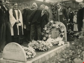
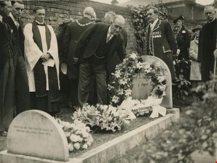
Ceremony at Vancouver's grave
https://search.heritageburnaby.ca/link/archivedescription36307
- Repository
- City of Burnaby Archives
- Date
- June 1, 1938
- Collection/Fonds
- Burnaby Historical Society fonds
- Description Level
- Item
- Physical Description
- 1 photograph : b&w ; 15.5 x 20 cm
- Scope and Content
- Photograph of the annual commemorative ceremony that takes place at Vancouver's grave in St. Peter’s churchyard in Petersham, England and is sponsored by the province of British Columbia.
- Repository
- City of Burnaby Archives
- Date
- June 1, 1938
- Collection/Fonds
- Burnaby Historical Society fonds
- Subseries
- George Grant subseries
- Physical Description
- 1 photograph : b&w ; 15.5 x 20 cm
- Description Level
- Item
- Record No.
- 243-027
- Access Restriction
- No restrictions
- Reproduction Restriction
- Reproduce for fair dealing purposes only
- Accession Number
- BHS1990-06
- Scope and Content
- Photograph of the annual commemorative ceremony that takes place at Vancouver's grave in St. Peter’s churchyard in Petersham, England and is sponsored by the province of British Columbia.
- Media Type
- Photograph
- Photographer
- Topical Press Agency Limited
- Notes
- Title based on contents of photograph
- Stamp on verso of photograph reads: "PHOTOGRAPH SUPPLIED BY THE TOPICAL PRESS LTD. 10-11, RED LION COURT FLEET STREET..LONDON, E.C.4."
Images
![Ernest Winch memorial tablet, [after 1957] thumbnail](/media/hpo/_Data/_BVM_Images/2000/200600120001.jpg?width=280)
Ernest Winch memorial tablet
https://search.heritageburnaby.ca/link/museumdescription2603
- Repository
- Burnaby Village Museum
- Date
- [after 1957]
- Collection/Fonds
- Burnaby Village Museum Photograph collection
- Description Level
- Item
- Physical Description
- 1 photograph : b&w ; 19.5 x 24 cm
- Scope and Content
- Photograph of a memorial tablet dedicated to Ernest E. Winch who is remembered on the plaque as "THE FOUNDER OF THE NEW VISTA SOCIETY", dedicated to providing care and support for seniors. The tablet is mounted on a stone resting on a cement foundation. Ernest Winch was also a reknowned labour acti…
- Repository
- Burnaby Village Museum
- Collection/Fonds
- Burnaby Village Museum Photograph collection
- Description Level
- Item
- Physical Description
- 1 photograph : b&w ; 19.5 x 24 cm
- Scope and Content
- Photograph of a memorial tablet dedicated to Ernest E. Winch who is remembered on the plaque as "THE FOUNDER OF THE NEW VISTA SOCIETY", dedicated to providing care and support for seniors. The tablet is mounted on a stone resting on a cement foundation. Ernest Winch was also a reknowned labour activist and Burnaby Member of the Legislative Assembly with the Co-operative Commonwealth Federation / New Democratic Party.
- Subjects
- Monuments
- Names
- Winch, Ernest "Ernie"
- Accession Code
- BV006.12.1
- Access Restriction
- Restricted access
- Reproduction Restriction
- May be restricted by third party rights
- Date
- [after 1957]
- Media Type
- Photograph
- Scan Resolution
- 600
- Scan Date
- 11-Jun-09
- Scale
- 100
- Notes
- Title based on contents of photograph
- Memorial tablet reads: "ERNEST E. WINCH / 1879 - 1957 / THE FOUNDER OF THE NEW VISTA SOCIETY / 'NOT AS A LADDER FROM EARTH TO HEAVEN, / NOT AS A WITNESS TO ANY CREED, / BUT IN SIMPLE SERVICE, SIMPLY GIVEN / TO ALL MANKIND IN NEED'."
Images
![Ernest Winch memorial tablet, [after 1957] thumbnail](/media/hpo/_Data/_BVM_Images/2000/200600120001.jpg)
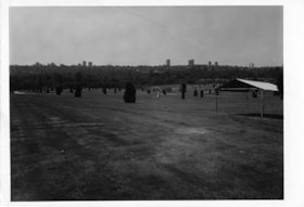
Forest Lawn Cemetery
https://search.heritageburnaby.ca/link/archivedescription93709
- Repository
- City of Burnaby Archives
- Date
- June 4, 1978
- Collection/Fonds
- Burnaby Public Library Contemporary Visual Archive Project
- Description Level
- Item
- Physical Description
- 1 photograph : b&w ; 12.5 x 17.5 cm
- Scope and Content
- Photograph of the grounds of the Forest Lawn Memorial Park cemetery, located by Royal Oak Avenue and Canada Way. Shrubs, gravestones, and a tent are across the lawn. The photograph is taken from on the grounds, facing south. High-rise buildings in the Metrotown area are visible in the distance.
- Repository
- City of Burnaby Archives
- Date
- June 4, 1978
- Collection/Fonds
- Burnaby Public Library Contemporary Visual Archive Project
- Physical Description
- 1 photograph : b&w ; 12.5 x 17.5 cm
- Description Level
- Item
- Record No.
- 556-666
- Access Restriction
- No restrictions
- Reproduction Restriction
- Reproduce for fair dealing purposes only
- Accession Number
- 2017-57
- Scope and Content
- Photograph of the grounds of the Forest Lawn Memorial Park cemetery, located by Royal Oak Avenue and Canada Way. Shrubs, gravestones, and a tent are across the lawn. The photograph is taken from on the grounds, facing south. High-rise buildings in the Metrotown area are visible in the distance.
- Subjects
- Monuments - Gravestones
- Cemeteries
- Media Type
- Photograph
- Photographer
- Surridge, Jack
- Notes
- Title taken from project information form
- Accompanied by a project information form and 1 photograph (b&w negative ; 9.5 x 12.5 cm)
- BPL no. 113
- Geographic Access
- Royal Oak Avenue
- Street Address
- 3789 Royal Oak Avenue
- Historic Neighbourhood
- Burnaby Lake (Historic Neighbourhood)
- Planning Study Area
- Douglas-Gilpin Area
Images


Highrises on Kingsway
https://search.heritageburnaby.ca/link/archivedescription93692
- Repository
- City of Burnaby Archives
- Date
- June 4, 1978
- Collection/Fonds
- Burnaby Public Library Contemporary Visual Archive Project
- Description Level
- Item
- Physical Description
- 1 photograph : b&w ; 12.5 x 17.5 cm
- Scope and Content
- Photograph of high-rises apartment buildings and the neighbourhood along Kingsway by Central Park. The photograph is taken from a high point, facing east down Kingsway. The Central Park Veterinary Hospital, Central Park Place, a railway crossing, a gas station, and the Central Park Gate are visible…
- Repository
- City of Burnaby Archives
- Date
- June 4, 1978
- Collection/Fonds
- Burnaby Public Library Contemporary Visual Archive Project
- Physical Description
- 1 photograph : b&w ; 12.5 x 17.5 cm
- Description Level
- Item
- Record No.
- 556-649
- Access Restriction
- No restrictions
- Reproduction Restriction
- Reproduce for fair dealing purposes only
- Accession Number
- 2017-57
- Scope and Content
- Photograph of high-rises apartment buildings and the neighbourhood along Kingsway by Central Park. The photograph is taken from a high point, facing east down Kingsway. The Central Park Veterinary Hospital, Central Park Place, a railway crossing, a gas station, and the Central Park Gate are visible in the photograph.
- Subjects
- Buildings - Commercial
- Buildings - Residential - Apartments
- Buildings - Commercial - Service Stations
- Geographic Features - Parks
- Monuments
- Media Type
- Photograph
- Photographer
- Chapman, Fred
- Notes
- Title taken from project information form
- Accompanied by a project information form and 1 photograph (b&w negative ; 9.5 x 12.5 cm)
- BPL no. 97
- Geographic Access
- Kingsway
- Central Park
- Historic Neighbourhood
- Central Park (Historic Neighbourhood)
- Planning Study Area
- Maywood Area
Images

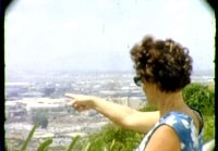
Visit to Hawaii and horseback riding
https://search.heritageburnaby.ca/link/archivedescription85438
- Repository
- City of Burnaby Archives
- Date
- 1970
- Collection/Fonds
- George H.F. McLean fonds
- Description Level
- Item
- Physical Description
- 1 digital file ( 3 min., 10 sec ) : digital , col., si.
- Scope and Content
- Item consists of one silent colour film of the McLean family visiting Hawaii. The film opens with Edna McLean sightseeing and views of the Hawaiian countryside, cities, monuments, buildings, trees and ocean. The film switches to Teresa McLean playing in a swimming pool and closes with Teresa feedin…
- Repository
- City of Burnaby Archives
- Date
- 1970
- Collection/Fonds
- George H.F. McLean fonds
- Physical Description
- 1 digital file ( 3 min., 10 sec ) : digital , col., si.
- Description Level
- Item
- Record No.
- 567-001-23
- Access Restriction
- No restrictions
- Reproduction Restriction
- May be restricted by third party rights
- Accession Number
- 2014-03
- Scope and Content
- Item consists of one silent colour film of the McLean family visiting Hawaii. The film opens with Edna McLean sightseeing and views of the Hawaiian countryside, cities, monuments, buildings, trees and ocean. The film switches to Teresa McLean playing in a swimming pool and closes with Teresa feeding a horse, and horseback riding with friends looking on.
- Media Type
- Moving Images
- Photographer
- McLean, George H.F.
- Notes
- Title based on content of film
- Films originated in an 8mm format and were digitized by George McLean before being donated to the CBA
Images
Video
Visit to Hawaii and horseback riding, 1970
Visit to Hawaii and horseback riding, 1970
https://search.heritageburnaby.ca/media/hpo/_Data/_Archives_Moving_Images/_Unrestricted/567-001-23.m4v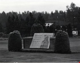
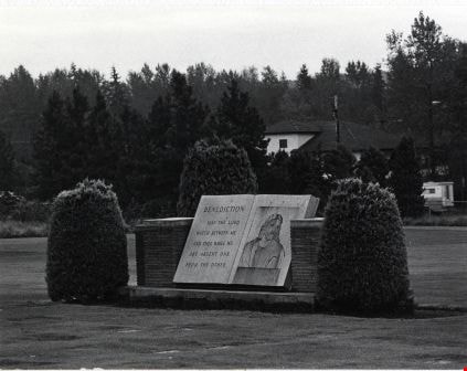
Forest Lawn Memorial Park
https://search.heritageburnaby.ca/link/archivedescription79072
- Repository
- City of Burnaby Archives
- Date
- November 14, 1976
- Collection/Fonds
- Burnaby Public Library Contemporary Visual Archive Project
- Description Level
- Item
- Physical Description
- 1 photograph : b&w ; 11 x 16 cm mounted on cardboard
- Scope and Content
- Photograph shows a monument in Forest Lawn Memorial Park at 3789 Royal Oak Avenue. The memorial park was founded in 1935.
- Repository
- City of Burnaby Archives
- Date
- November 14, 1976
- Collection/Fonds
- Burnaby Public Library Contemporary Visual Archive Project
- Physical Description
- 1 photograph : b&w ; 11 x 16 cm mounted on cardboard
- Description Level
- Item
- Record No.
- 556-134
- Access Restriction
- No restrictions
- Reproduction Restriction
- Reproduce for fair dealing purposes only
- Accession Number
- 2013-13
- Scope and Content
- Photograph shows a monument in Forest Lawn Memorial Park at 3789 Royal Oak Avenue. The memorial park was founded in 1935.
- Subjects
- Cemeteries
- Media Type
- Photograph
- Photographer
- Campbell, Peg
- Notes
- Scope note taken directly from BPL photograph description.
- 1 b&w copy negative : 10 x 12.5 cm accompanying
- Geographic Access
- Royal Oak Avenue
- Street Address
- 3789 Royal Oak Avenue
- Planning Study Area
- Douglas-Gilpin Area
Images