Narrow Results By
Subject
- Accidents 1
- Accidents - Automobile Accidents 2
- Advertising Medium - Signs and Signboards 2
- Agricultural Tools and Equipment - Plows 1
- Animals 1
- Animals - Birds 1
- Arts 2
- Arts - Sculptures 1
- Bedding - Quilt 1
- Buildings - Civic 1
- Buildings - Civic - Libraries 8
- Buildings - Commercial - Automobile Dealerships 1

Maywood Neighbourhood
https://search.heritageburnaby.ca/link/landmark801
- Repository
- Burnaby Heritage Planning
- Associated Dates
- 1955-2008
- Heritage Value
- Burnaby's Maywood Neighbourhood consists of the Metrotown Town Centre - one of four Town Centres in the City. Metrotown is one of the region's most developed and fastest growing centres. It is served by the first SkyTrain line developed in the mid-1980s and anchored by B.C.'s largest shopping and entertainment complex. As an older centre that has progressively added new developments over the years, Metrotown offers a range of housing types and tenures from three-storey walk-up apartments to modern residential towers.
- Historic Neighbourhood
- Central Park (Historic Neighbourhood)
- Planning Study Area
- Maywood Area
Images


Sussex-Nelson Neighbourhood
https://search.heritageburnaby.ca/link/landmark838
- Repository
- Burnaby Heritage Planning
- Associated Dates
- 1955-2008
- Heritage Value
- The Sussex-Nelson Neighbourhood is located just south of Metrotown and in 1980 was characterised as the most populated of all of Burnaby's Planning Study areas. The area immediately south of Metrotown was initially developed as post-war 1950s housing stock, while the sector south of Rumble was developed after the 1960s and 1970s as single-family housing.
- Historic Neighbourhood
- Alta Vista (Historic Neighbourhood)
- Planning Study Area
- Sussex-Nelson Area
Images

Evelyn Salisbury subseries
https://search.heritageburnaby.ca/link/archivedescription45
- Repository
- City of Burnaby Archives
- Date
- 1870 (date of original)-1991
- Collection/Fonds
- Burnaby Historical Society fonds
- Description Level
- Subseries
- Physical Description
- 2 m of textual records and other material
- Scope and Content
- Subseries consists of textual records and photographs that were collected by Lillian Evelyn Salisbury during her lifetime as a citizen of Burnaby. Records document historical sites and events in and related to Burnaby, as well as various heritage groups and events in British Columbia. Included in t…
- Repository
- City of Burnaby Archives
- Date
- 1870 (date of original)-1991
- Collection/Fonds
- Burnaby Historical Society fonds
- Subseries
- Evelyn Salisbury subseries
- Physical Description
- 2 m of textual records and other material
- Description Level
- Subseries
- Accession Number
- BHS1985-04
- BHS1985-15
- BHS1986-12
- BHS1986-25
- BHS1986-26
- BHS1987-04
- BHS1989-13
- BHS1989-18
- BHS1991-24
- Scope and Content
- Subseries consists of textual records and photographs that were collected by Lillian Evelyn Salisbury during her lifetime as a citizen of Burnaby. Records document historical sites and events in and related to Burnaby, as well as various heritage groups and events in British Columbia. Included in this subseries are the publication and papers related to "Metrotown - Burnaby Heritage Resource Inventory."
- History
- Lillian Evelyn "Evelyn" Salisbury was born in 1915 and moved to Burnaby in 1945. She had three children with her husband Fred: Gordon, Lorne, and Karen. While living in Burnaby, she worked with the Red Cross blood donor clinic and the Burnaby Health Unit. In 1958, she participated in the Greater Vancouver Health League’s campaign for fluoridation as the Health Chairman of the Burnaby Parent-Teacher Council. Evelyn Salisbury served two-year terms as secretary, vice-president and president of the Burnaby Historical Society and spearheaded a 1985 project to record Burnaby’s historical inventory of churches, schools, industries, homes and other pre-1930 buildings. When the building of Metrotown shopping centre threatened to clear historic homes in Central Park area, the Society produced a record of the historic buildings in the area. In 1988, as president of the Burnaby Historical Society, she convinced City of Burnaby aldermen to set up a heritage advisory committee. She was appointed to the Burnaby Centennial Committee the next year and in 1990 she was named Citizen of the Year by the Burnaby City Council. During her lifetime, Evelyn Salisbury endeavoured to collect papers of historical significance. She died in 1991.
- Media Type
- Textual Record
- Photograph
- Creator
- Salisbury, Evelyn
- Notes
- Title based on creator of subseries
- PC145, PC177, PC178, PC195, PC221, PC261, MSS061
Bailey family subseries
https://search.heritageburnaby.ca/link/archivedescription64465
- Repository
- City of Burnaby Archives
- Date
- 1890 (date of original0-1958
- Collection/Fonds
- Burnaby Historical Society fonds
- Description Level
- Subseries
- Physical Description
- Textual records and photographs
- Scope and Content
- Subseries consists of publications, ephemera and photographs pertaining to the Bailey family.
- Repository
- City of Burnaby Archives
- Date
- 1890 (date of original0-1958
- Collection/Fonds
- Burnaby Historical Society fonds
- Subseries
- Bailey family subseries
- Physical Description
- Textual records and photographs
- Description Level
- Subseries
- Accession Number
- BHS1992-55
- Scope and Content
- Subseries consists of publications, ephemera and photographs pertaining to the Bailey family.
- History
- Charles William Bailey was born in St. Thomas, Ontario on September 1, 1887. Shortly after, his family moved to the west coast. After the Vancouver fire of 1896, his family moved to Burnaby and acquired seven acres of government-offered land. Charles married Sapperton-born Minnie Bendle Booth in New Westminster on January 2, 1914, just seven days shy of her sixteenth birthday. Charles worked for Vancouver Iron Works and the couple lived at 1505 11th Avenue in Burnaby. Their first child, Frank Albert William Bailey was born at the house on May 19, 1916. Winnifred Patricia Bailey was born in the same house May 25, 1918. Theodore Bailey was born August 8, 1919 but only lived until August 12 of the same year. Their fourth child, Norman Charles Edward "Charlie" Bailey was born at the Royal Columbian Hospital, New Westminster, BC on September 1, 1922. Frank was a member of Division XIII at Kingsway West School in 1922. Winnifred was a member of class seven at Burnaby South High School in 1932. By 1958, both Charlie and Frank were married and Minnie and Charles had three grandsons and one granddaughter. From 1922, the family lived at 3125 Kathleen Avenue, Burnaby (later renumbered 6080 Kathleen Avenue). In 1995, the Bailey family house at 6080 Kathleen Avenue was acquired by the City of Burnaby as part of the Metrotown Development Plan. The property was purchased for land development purposes and the house demolished.
- Media Type
- Textual Record
- Photograph
- Creator
- Bailey, Charles
- Notes
- Title based on contents of subseries
- MSS115, PC508
Patterson family subseries
https://search.heritageburnaby.ca/link/archivedescription32
- Repository
- City of Burnaby Archives
- Date
- 1898-1952
- Collection/Fonds
- Burnaby Historical Society fonds
- Description Level
- Subseries
- Physical Description
- Textual records and photographs
- Scope and Content
- Subseries consists of documents and photographs pertaining to the Patterson family.
- Repository
- City of Burnaby Archives
- Date
- 1898-1952
- Collection/Fonds
- Burnaby Historical Society fonds
- Subseries
- Patterson family subseries
- Physical Description
- Textual records and photographs
- Description Level
- Subseries
- Accession Number
- BHS1986-19
- BHS1986-20
- BHS1988-13
- BHS1995-16
- BHS1996-05
- BHS1996-11
- Scope and Content
- Subseries consists of documents and photographs pertaining to the Patterson family.
- History
- Frances Mabel "May" Webb was born in Cradley, England on December 5, 1872. She sailed from England to Victoria, BC with her parents, Joseph William Webb and Frances Jane Webb (nee Yapp) on the SS Lake Winnipeg in 1889. One of the few possessions that she brought with her was an old wood-rimmed bicycle which she found quite useful after her move to Burnaby. She would ride it all the way from Patterson’s Trail and Westminster Road (today’s Patterson Avenue and Kingsway) to the Woodward’s store in Vancouver where she would place her grocery order. She packed a pearl handled revolver with her in order to scare any bears she might see along her ride. In 1890, Frances married Dugald Campbell Patterson (b. 1860, d. 1931) in Victoria, BC. In 1894, the couple built a pioneer homestead and farm on five acres at what would become the north east section of Central Park. Dugald founded Vulcan Iron Works (later Dominion Bridge Company) in New Westminister in 1903, and the couple settled in the Central Park district. By 1904, the family moved to the Edmonds district where in 1909 she operated the post office that her husband founded. In 1910, they began construction of a new house, complete with tennis courts and a gazebo, on 14 acres purchased for $720. The house is now located at 7106 18th Avenue and is a dedicated heritage building. The couple had seven children: William H. "Bill", Jean, Frances Mabel Lili., Dugald C. Jr, Mary, Charles Bruce, and Alice. The Pattersons were community-minded citizens that served Burnaby through their involvement with local municipal affairs and politics. In 1909, Dugald became the first postmaster of Edmonds. He also served as a School Trustee from 1912-13 and was one of the first residents to lobby Burnaby City Council to preserve the local ravines as parks. They also helped build the Central Park Presbyterian Church, along with other pioneer families. The family name is remembered and honoured by the naming of Patterson Avenue and the Patterson SkyTrain Station located in the Metrotown area. Frances Mabel assisted her husband with an insurance and real estate company that he founded in Burnaby and New Westminster. This experience would prove invaluable, as she would later become an insurance agent for the Wawanesa Insurance Company (founded in 1896). Frances never owned an automobile, so she met her insurance clients all over Burnaby, New Westminster and Vancouver by using the Lower Mainland’s street car system. The insurance profession continued to provide her with a steady income long after her husband’s death. Frances Mabel died in New Westminster, BC on August 30, 1960. Frances Mabel Lili Patterson was born on June 9, 1905 and was the fifth child born to Dugald Campbell and Frances Mabel Patterson. She became the first PBX switchboard operator for the Municipality of Burnaby in the early 1920’s. PBX, or Private Branch Exchange, was the term used for an internal telephone system. Frances later became president of the Professional Women’s Association of New Westminster, and volunteered her time with the May Day celebrations in New Westminster. She was also a dedicated member of the Rebekah Lodge (the women’s division of the Independent Order of Odd Fellows). While in the lodge, she met her future husband, Walter Duke and they married on July 12, 1939. They couple moved to Wenatchee, Washington after getting married, and Frances relocated to Victoria after her husband died. Frances died on January 13, 1974. Doreen Nettie Patterson was born December 12, 1927, the youngest daughter of Charles Bruce Patterson and Elva Eleanore Patterson (nee Elliott). At age 23, Doreen became the first woman from BC to enlist in the new Women’s Royal Canadian Naval Service and by the fall of 1951, she had become a Wren in the Royal Canadian Navy. She received her basic training at HMCS Cornwallis and became a radio intelligence operator for the wireless communications base at Naval Radio Station Coverdale near Moncton, New Brunswick. In 1953, she was chosen to serve a term at the naval base in Churchill, Manitoba. She was one of only eleven women to ever serve there. After her career in the navy, Doreen worked in the accounting division for Simpsons-Sears in Burnaby near her grandparent’s original family home at Patterson Avenue and Kingsway. Doreen married Gerard Reitsma on August 18, 1960. Doreen died on April 30, 2000.
- Media Type
- Textual Record
- Photograph
- Notes
- Title based on contents of subseries
- PC171, PC213, PC322, PC326, MSS024, MSS039
Burnaby Public Library photograph subseries
https://search.heritageburnaby.ca/link/archivedescription58147
- Repository
- City of Burnaby Archives
- Date
- 1908-1973
- Collection/Fonds
- Burnaby Historical Society fonds
- Description Level
- Subseries
- Physical Description
- Photographs
- Scope and Content
- Subseries consists of historical photographs of Burnaby collected by the Burnaby Public Library.
- Repository
- City of Burnaby Archives
- Date
- 1908-1973
- Collection/Fonds
- Burnaby Historical Society fonds
- Physical Description
- Photographs
- Description Level
- Subseries
- Accession Number
- BHS1989-22
- Scope and Content
- Subseries consists of historical photographs of Burnaby collected by the Burnaby Public Library.
- History
- Burnaby's first library was founded in 1927 as the North Burnaby Library Association. Its first library building was established in 1935 on Hastings Street. In 1954, Burnaby enacted Bylaw No. 3522 to establish the Burnaby Public Library (BPL) and in 1957 BPL merged with the North Burnaby Library Association. BPL's first permanent library was the McGill branch, built in North Burnaby in 1961 and named after North Burnaby Library Association volunteer Grace McGill. Following McGill, BPL then established the Kingsway branch, Central Park branch, and Cameron branch. Central Park was replaced by the Bob Prittie Metrotown branch in 1991 and Kingsway with the Tommy Douglas branch in 2009.
- Media Type
- Photograph
- Creator
- Burnaby Public Library
- Notes
- PC225, PC226, PC227, PC228, PC229, PC230, PC231, PC232, PC322, and PC427
- Title based on creator of subseries

D.C. Patterson House
https://search.heritageburnaby.ca/link/landmark517
- Repository
- Burnaby Heritage Planning
- Description
- The D.C. Patterson House is a one and one-half storey plus basement wood-frame Edwardian era residence with a full-width front verandah and symmetrical saddlebag dormers. It is located adjacent to a ravine park and is part of the Winston Gate development.
- Associated Dates
- 1910
- Formal Recognition
- Heritage Designation, Community Heritage Register
- Other Names
- Dugald & Frances Patterson House
- Street View URL
- Google Maps Street View
- Repository
- Burnaby Heritage Planning
- Other Names
- Dugald & Frances Patterson House
- Geographic Access
- 12th Avenue
- Associated Dates
- 1910
- Formal Recognition
- Heritage Designation, Community Heritage Register
- Enactment Type
- Bylaw No. 10062
- Enactment Date
- 11/07/1994
- Description
- The D.C. Patterson House is a one and one-half storey plus basement wood-frame Edwardian era residence with a full-width front verandah and symmetrical saddlebag dormers. It is located adjacent to a ravine park and is part of the Winston Gate development.
- Heritage Value
- This house is significant for its associations with the Patterson family, who were early Burnaby pioneers. Dugald Campbell Patterson (1860-1931) and Frances Mabel Patterson (1872-1960) arrived in 1894 and settled in the Central Park district. In 1910, they relocated to the Edmonds District and built this family residence on Edmonds Street near Kingsway. The Pattersons were community minded citizens who served Burnaby through their involvement with local municipal affairs and politics. Dugald Patterson served as a School Trustee in 1912-13 and was one of the first residents to lobby council to preserve the local ravines as parks. The family name is remembered and honoured by the naming of Patterson Avenue and the Patterson SkyTrain Station located in the Metrotown area. Additionally, the D.C. Patterson House is significant as a fine example of a vernacular Edwardian era family house. The typical design of the Patterson House was taken from an Edwardian era pattern book, and demonstrates how standardized plans were commonly used by local owners and builders to expedite the construction process. This house has survived in an excellent state of preservation. Although moved from its original site, it remains as an intact representation of a middle-class Burnaby residence of the Edwardian era.
- Defining Elements
- Key elements that define the heritage character of the D.C. Patterson House include its: - vernacular residential form, scale and massing as exemplified by its one and one-half storey plus basement height, front gabled roof with hipped return over front verandah, symmetrical saddlebag dormers and rectangular, side hall plan with an asymmetrical front entry - typical Edwardian era construction features such as the deep boxed eaves, lapped wooden siding and cedar shingle roofing - projecting front gable peak, clad in decorative random-coursed square shingles, with eave brackets under and a louvered attic vent - projecting elements on the main floor including a square bay on the east side and a semi-octagonal bay to the west side - full-width open front verandah with irregularly-spaced square columns - closed balustrades with drainage scuppers on the front verandah and rear side porch - regular fenestration, including double hung 1-over-1 wooden-sash windows with proportionately smaller upper sash, triple assembly of windows in the front gable, and leaded glass in main floor front window - original front door with inset bevelled glass light
- Historic Neighbourhood
- Edmonds (Historic Neighbourhood)
- Planning Study Area
- Stride Hill Area
- Function
- Primary Historic--Single Dwelling
- Primary Current--Single Dwelling
- Community
- Burnaby
- Cadastral Identifier
- 003-008-321
- Boundaries
- The D.C. Patterson House is comprised of a single residential lot located at 7106 Eighteenth Avenue, Burnaby.
- Area
- 5176
- Contributing Resource
- Building
- Ownership
- Private
- Street Address
- 7106 18th Avenue
- Street View URL
- Google Maps Street View
Images


![Land clearing crew, [1912] (date of original), copied 1991 thumbnail](/media/hpo/_Data/_Archives_Images/_Unrestricted/370/370-778.jpg?width=280)
Land clearing crew
https://search.heritageburnaby.ca/link/archivedescription38191
- Repository
- City of Burnaby Archives
- Date
- [1912] (date of original), copied 1991
- Collection/Fonds
- Burnaby Historical Society fonds
- Description Level
- Item
- Physical Description
- 1 photograph : b&w ; 3.2 x 4.8 cm print on contact sheet 20.4 x 26.5 cm
- Scope and Content
- Photograph of a land clearing crew, with horses and tools, in the Metrotown area near McKay Avenue.
- Repository
- City of Burnaby Archives
- Date
- [1912] (date of original), copied 1991
- Collection/Fonds
- Burnaby Historical Society fonds
- Subseries
- Burnaby Image Bank subseries
- Physical Description
- 1 photograph : b&w ; 3.2 x 4.8 cm print on contact sheet 20.4 x 26.5 cm
- Description Level
- Item
- Record No.
- 370-778
- Access Restriction
- No restrictions
- Reproduction Restriction
- No known restrictions
- Accession Number
- BHS1999-03
- Scope and Content
- Photograph of a land clearing crew, with horses and tools, in the Metrotown area near McKay Avenue.
- Media Type
- Photograph
- Notes
- Title based on contents of photograph
- 1 b&w copy negative accompanying
- Negative has a pink cast
- Geographic Access
- McKay Avenue
- Historic Neighbourhood
- Central Park (Historic Neighbourhood)
- Planning Study Area
- Maywood Area
Images
![Land clearing crew, [1912] (date of original), copied 1991 thumbnail](/media/hpo/_Data/_Archives_Images/_Unrestricted/370/370-778.jpg)

J.A. Thurston House 'Altese'
https://search.heritageburnaby.ca/link/landmark511
- Repository
- Burnaby Heritage Planning
- Description
- The J.A. Thurston House is a very large, two and one-half storey plus basement wood-frame Arts and Crafts style house. It is located on the south side of Thurston Street, near Kingsway and the SkyTrain (formerly the interurban tramline route), within the Metrotown area of Burnaby and is now part of…
- Associated Dates
- 1912
- Formal Recognition
- Heritage Designation, Community Heritage Register
- Other Names
- John A. & Sarah Thurston House
- Street View URL
- Google Maps Street View
- Repository
- Burnaby Heritage Planning
- Other Names
- John A. & Sarah Thurston House
- Geographic Access
- Thurston Street
- Associated Dates
- 1912
- Formal Recognition
- Heritage Designation, Community Heritage Register
- Enactment Type
- Bylaw No. 9934
- Enactment Date
- 09/08/1993
- Description
- The J.A. Thurston House is a very large, two and one-half storey plus basement wood-frame Arts and Crafts style house. It is located on the south side of Thurston Street, near Kingsway and the SkyTrain (formerly the interurban tramline route), within the Metrotown area of Burnaby and is now part of a large apartment complex.
- Heritage Value
- The J.A. Thurston House demonstrates Burnaby's real estate and construction boom along the interurban tramline in 1911. The house was built for John Albert Thurston (1874-1944) and his wife Sarah Sedona Thurston (1879-1961). Typical of the entrepreneurial spirit of the age, John Thurston, a manager for the Leckie Shoe Company Limited in Vancouver, was also involved in real estate development, and purchased a twenty-one lot subdivision consisting of 3.2 hectares bound by the interurban tramline right-of-way to the south, Boundary Road to the west and Smith Street (now Thurston Street) to the north. Additionally, the J.A. Thurston House is an excellent, high quality example of an Arts and Crafts style dwelling, with numerous notable design elements such as the battered piers, the elaborate second storey dormer and stained glass windows with landscape and seascape motifs. The enormous scale of the house reflects a time when large families were common and domestic servants were needed to run the household. Indicative of the labour-saving devices and luxury features being introduced at the high end of the housing market, it was equipped with a built-in vacuum system, refrigeration, servant summoning devices and a round safe built into a fireplace mantle. The J.A. Thurston House also represents the proliferation during the Edwardian era of homes built from pattern books and standardized designs as a means to expedite the construction process and offer competitive costs.
- Defining Elements
- Key elements that define the heritage character of the J.A. Thurston House include its: - location on Thurston Street, in the old Central Park district - residential form, scale and massing as exemplified by its two and one-half storey plus above-ground basement height and regular, rectangular plan - Arts and Crafts style details such as the picturesque roofline, deep open eaves with exposed purlins, narrow lapped wooden siding on the first storey and cedar shingle siding on the upper storeys - broad and unusually steep side gabled roof, clad with cedar shingles - deeply-recessed full open front verandah with complementary recessed balcony in second storey dormer, incorporating both a gabled roof and shed roof - twinned and triple square bracketed columns on the verandahs and balcony - decorative battered verandah piers, supported on exposed beams - irregular fenestration, including: double-hung wooden-sash windows; picture windows; casement windows; and several stained glass windows with landscape and seascape motifs - tall brick external chimney on east facade - original interior features such as fireplaces, and wooden trim and floors
- Historic Neighbourhood
- Central Park (Historic Neighbourhood)
- Planning Study Area
- Garden Village Area
- Function
- Primary Historic--Single Dwelling
- Primary Current--Single Dwelling
- Community
- Burnaby
- Cadastral Identifier
- 018-224-113
- Boundaries
- The J.A. Thurston House is comprised of a single residential lot located at 3762 Thurston Street, Burnaby.
- Area
- 3880
- Contributing Resource
- Building
- Ownership
- Private
- Street Address
- 3762 Thurston Street
- Street View URL
- Google Maps Street View
Images


William Wilson House
https://search.heritageburnaby.ca/link/landmark512
- Repository
- Burnaby Heritage Planning
- Description
- The William Wilson House is a vernacular two-storey wood-frame Foursquare house with a hipped roof. It is situated at the corner of Wilson Avenue and Central Boulevard in the Metrotown area of Burnaby, adjacent to the SkyTrain line, and is now part of a multi-family residential complex.
- Associated Dates
- 1913
- Formal Recognition
- Heritage Designation, Community Heritage Register
- Other Names
- William & Annie Wilson House
- Street View URL
- Google Maps Street View
- Repository
- Burnaby Heritage Planning
- Other Names
- William & Annie Wilson House
- Geographic Access
- Wilson Avenue
- Associated Dates
- 1913
- Formal Recognition
- Heritage Designation, Community Heritage Register
- Enactment Type
- Bylaw No. 10350
- Enactment Date
- 22/04/1996
- Description
- The William Wilson House is a vernacular two-storey wood-frame Foursquare house with a hipped roof. It is situated at the corner of Wilson Avenue and Central Boulevard in the Metrotown area of Burnaby, adjacent to the SkyTrain line, and is now part of a multi-family residential complex.
- Heritage Value
- The house is valued as the residence of William Wilson (1860-1935) and Annie Wilson (1868-1966) and demonstrates the development of Burnaby from a rural, farming community to an early commuter suburb, and is one of the few remaining early houses in the Metrotown area of Burnaby. Reflecting the area's early history, it was constructed on a subdivided piece of the Wilson’s 3.2 hectare farm that once bordered Kingsway, the primary road linking New Westminster to Vancouver. To develop his subdivided property, Wilson constructed a bisecting street, named it for himself and situated his new home on a large parcel adjacent to the interurban tramline. Constructed in 1913, the William Wilson House is additionally valued as a modest vernacular example of an Edwardian era Foursquare house. Although simple in form, it is distinguished by an inset front verandah, front bay window and clipped ground level corner. Once commonly found in Burnaby, this is a rare surviving example of the homes typically constructed for the working-class families enticed to Burnaby as a consequence of the interurban tramline.
- Defining Elements
- Key elements that define the heritage character of William Wilson House include its: - corner location, adjacent to the old interurban alignment - vernacular Foursquare style as exemplified by its symmetrical form, square floor plan and cubic massing with pyramidal roof - cladding, with narrow lapped wooden siding on the first storey and cedar shingles on the second storey - recessed front verandah, with square columns and ground floor cut-away bay window - regular fenestration, including double-hung 1-over-1 wooden-sash windows, and casement and transom assembly feature window in the living room
- Historic Neighbourhood
- Central Park (Historic Neighbourhood)
- Planning Study Area
- Maywood Area
- Function
- Primary Historic--Single Dwelling
- Primary Current--Single Dwelling
- Community
- Burnaby
- Cadastral Identifier
- 023-352-701
- Boundaries
- The William Wilson House is comprised of a single residential lot located at 6088 Wilson Avenue, Burnaby.
- Area
- 2824.9
- Contributing Resource
- Building
- Ownership
- Private
- Street Address
- 6088 Wilson Avenue
- Street View URL
- Google Maps Street View
Images


![Mr. Manuel with a plough, [192-] (date of original), copied 1991 thumbnail](/media/hpo/_Data/_Archives_Images/_Unrestricted/370/370-100.jpg?width=280)
Mr. Manuel with a plough
https://search.heritageburnaby.ca/link/archivedescription37512
- Repository
- City of Burnaby Archives
- Date
- [192-] (date of original), copied 1991
- Collection/Fonds
- Burnaby Historical Society fonds
- Description Level
- Item
- Physical Description
- 1 photograph : b&w ; 3.1 x 5.3 cm print on contact sheet 20.3 x 25.3 cm
- Scope and Content
- Photograph of Mr. Manuel working a plough pulled by two horses at Cassie Avenue (later the location of Metrotown).
- Repository
- City of Burnaby Archives
- Date
- [192-] (date of original), copied 1991
- Collection/Fonds
- Burnaby Historical Society fonds
- Subseries
- Burnaby Image Bank subseries
- Physical Description
- 1 photograph : b&w ; 3.1 x 5.3 cm print on contact sheet 20.3 x 25.3 cm
- Description Level
- Item
- Record No.
- 370-100
- Access Restriction
- No restrictions
- Reproduction Restriction
- No known restrictions
- Accession Number
- BHS1999-03
- Scope and Content
- Photograph of Mr. Manuel working a plough pulled by two horses at Cassie Avenue (later the location of Metrotown).
- Subjects
- Geographic Features - Fields
- Transportation - Horses
- Agricultural Tools and Equipment - Plows
- Occupations - Farmers
- Media Type
- Photograph
- Notes
- Title based on contents of photograph
- 1 b&w copy negative accompanying
- Geographic Access
- Cassie Avenue
- Historic Neighbourhood
- Central Park (Historic Neighbourhood)
- Planning Study Area
- Maywood Area
Images
![Mr. Manuel with a plough, [192-] (date of original), copied 1991 thumbnail](/media/hpo/_Data/_Archives_Images/_Unrestricted/370/370-100.jpg)
Hazel L'Estrange subseries
https://search.heritageburnaby.ca/link/archivedescription58365
- Repository
- City of Burnaby Archives
- Date
- 1948-1965
- Collection/Fonds
- Burnaby Historical Society fonds
- Description Level
- Subseries
- Physical Description
- Textual records and photographs
- Scope and Content
- Subseries consists of records collected by Hazel L'Estrange. Records include documents pertaining to the namining of the Bob Prittie Metrotown branch, a minute book for the North Burnaby Committee on Radiation Hazards, and photographs of Simon Fraser University (SFU).
- Repository
- City of Burnaby Archives
- Date
- 1948-1965
- Collection/Fonds
- Burnaby Historical Society fonds
- Subseries
- Hazel L'Estrange subseries
- Physical Description
- Textual records and photographs
- Description Level
- Subseries
- Accession Number
- BHS1992-27
- BHS1991-10
- Scope and Content
- Subseries consists of records collected by Hazel L'Estrange. Records include documents pertaining to the namining of the Bob Prittie Metrotown branch, a minute book for the North Burnaby Committee on Radiation Hazards, and photographs of Simon Fraser University (SFU).
- Media Type
- Textual Record
- Photograph
- Creator
- L'Estrange, Hazel
- Notes
- Title based on creator of subseries
- MSS074, MSS052, PC248, PC372

Digney Speedway
https://search.heritageburnaby.ca/link/landmark693
- Repository
- Burnaby Heritage Planning
- Geographic Access
- MacPherson Avenue
- Irmin Street
- Associated Dates
- 1948
- Heritage Value
- Andy Digney built the speedway in South Burnaby in 1948. He was approached by the B.C. Midget Auto Racing Association, who were looking for a good location to race the smaller, racing cars, popular at the time. Digney owned property in the vicinity of present-day Metrotown that was centrally located and easily accessible via the interurban railway. Motorcycles were also raced in the early days of the track. In 1949, when the popularity of midget racing declined, Digney started racing roadsters. However, he struggled to find local drivers, and it was expensive to bring in drivers from elsewhere. In 1951 Digney found a winner: jalopy racing. Local men would buy 1930s cars and strip them down, remove the glass, and weld the doors shut. By early 1952 over forty cars were showing up for jalopy races. By the early 1950s the Speedway was well established, with coverage in the sports pages and on radio. The track closed down in 1958 when Andy retired.
- Historic Neighbourhood
- Alta Vista (Historic Neighbourhood)
- Planning Study Area
- Clinton-Glenwood Area
Images

Simpsons-Sears Limited Burnaby fonds
https://search.heritageburnaby.ca/link/museumdescription17413
- Repository
- Burnaby Village Museum
- Date
- 1954-1959, predominant 1954-1955
- Collection/Fonds
- Simpsons-Sears Limited Burnaby fonds
- Description Level
- Fonds
- Physical Description
- 114 photographs + 15 cm of textual records
- Scope and Content
- Fonds consists of photographs and textual records from a scrapbook documenting the early years of the Simpsons-Sears store located at 3660 Kingsway (after 1959 - 4750 Kingsway) in Burnaby including the opening day and staff events. Many of the photographs depict, Manager of Simpsons-Sears, Burnaby,…
- Repository
- Burnaby Village Museum
- Collection/Fonds
- Simpsons-Sears Limited Burnaby fonds
- Description Level
- Fonds
- Physical Description
- 114 photographs + 15 cm of textual records
- Scope and Content
- Fonds consists of photographs and textual records from a scrapbook documenting the early years of the Simpsons-Sears store located at 3660 Kingsway (after 1959 - 4750 Kingsway) in Burnaby including the opening day and staff events. Many of the photographs depict, Manager of Simpsons-Sears, Burnaby, T. Boyd Haskell and include photographs regarding activities of the Greater Vancouver Tourist Association in which T. Boyd Haskell was president 1958-1959. Textual records within fonds include a financial ledger (1954-1956) as well as congratulatory telegrams and cards addressed to Simpsons-Sears staff and managers regarding the Simpsons-Sears store opening in May 1954 along with lists of names of Simpsons-Sears and Sears-Roebuck executive members who visited the store. Records are arranged into the following series: 1) Simpsons-Sears scrapbook series 2) Burnaby Simpsons-Sears adminstrative records series
- History
- In 1952, U.S. Chairman of Sears-Roebuck and Company, General Robert E.Wood, contacted President of Robert Simpson Company, Edgar G. Burton proposing a partnership between the two companies to serve the Canadian retail market. In September 1952, a merger was signed between the two to create Simpsons-Sears Limited. The terms of the agreement were 50-50. The two main objectives were to expand the Simpsons’ mail order business which was sold to the new company and to build new retail stores across Canada that were modelled on the Sears, Roebuck’s design. In early 1953, operations began with the first Simpsons-Sears Spring/Summer catalogue that was delivered to 300,00 homes across Canada. In September 1953, the first Simpsons-Sears retail store opened in Stratford Ontario and in December 1953 the second store opened in Kamloops, B.C. In 1953, with a 7.6 million dollar investment, construction began on the Simpsons-Sears store located at 3660 Kingsway in Burnaby. This was the second Simpsons-Sears store to be built in British Columbia. The store was designed by two Vancouver architectural firms Sharp, Thompson, Berwick and Pratt and Gardiner and Thornton. The new Burnaby Simpsons-Sears was touted as the most modern mall in Canada with the facing of the store consisting of Travertine marble imported from Italy and the main floor included fourty eight miles of brass strips incorporated in the terrazzo floor which was made from marble chips mixed with white Portland concrete. An exterior promenade, built from British Columbia fir and bolted with copper and brass was built around the exterior of the store. The promenade provided an outdoor display area for garden furniture and other large items. The retail store officially opened on May 5, 1954 with Simpsons-Sears executive members, managers and the Reeve of Burnaby in attendance. T. Boyd Haskell, from Spokane, Washington was hired as the Burnaby retail store manager and C.W. Jaggs, former Simpsons' general manager for British Columbia became manager of the Simpsons-Sears mail order business in British Columbia. A ribbon cutting ceremony took place during the opening event with Burnaby Reeve Charles W. MacSorley in attendance along with other dignitaries from Simpsons-Sears including President of Simpsons-Sears, E.G. Burton; Chairman of the board of Simpsons-Sears, Charles W. Burton; Vice President of Simpsons-Sears, G.F. Trotter; Mail Order Manager for Simpsons-Sears, B.C., C.W. Jaggs and Manager of Simpsons-Sears, Burnaby, T. Boyd Haskell. Over 10,000 people attended the opening of the store at 11:00 a.m. and it is believed that throughout the day, over 75,000 people went through the new store. T. Boyd Haskell was manager of the Burnaby Simpsons-Sears store between 1953 and 1962. After graduating from college, Haskell joined the Sears-Roebuck department store chain. In 1953 he moved to Vancouver from Washington State to set up the new store in Burnaby. In 1962, Haskell left Simpsons-Sears in Burnaby and transferred to the Sears store in Los Angeles. During his time in British Columbia, Haskell served as the President of the Greater Vancouver Tourist Association (1958-1959), President of the Community Chest and Councils of Greater Vancouver (1960) and was also a member of the board of directors of the B.C. Lions football team. Haskell died in Arizona in 1969 at the age of 54 years. In 1978, the Hudson’s Bay Company purchased “Simpsons” and converted many of the department stores into The Bay, including the store in downtown Toronto. Sears stores continued to carry the name “Simpsons-Sears” until 1984 when the named changed to “Sears Canada”. The Simpsons-Sears store (later named "Sears") located at 4750 Kingsway (Metropolis at Metrotown) closed it's doors in 2018.
- Creator
- Simpsons-Sears Limited
- Accession Code
- BV021.26
- BV022.17
- Date
- 1954-1959, predominant 1954-1955
- Media Type
- Photograph
- Textual Record
- Related Material
- See also: memorial program for T.B. Haskell in Burnaby Village Museum artifact collection BV021.26.166
- Arrangement
- Arrangement of records is based on original order of scrapbook and financial ledger by creator(s). Photographs and textual records were described in the order that they were arranged within original scrapbook prior to being removed.
- Notes
- Title based on contents of fonds

Burnaby Lake slide show
https://search.heritageburnaby.ca/link/archivedescription91684
- Repository
- City of Burnaby Archives
- Date
- 1976-1999
- Collection/Fonds
- Doreen Lawson fonds
- Description Level
- File
- Physical Description
- 85 photographs : col. slides ; 35 mm
- Scope and Content
- File consists of photographs compiled by Doreen Lawson for slideshow presentations about Burnaby Lake. Slideshow primarily depicts the wildlife and foliage of Burnaby Lake, including: the painted turtle, heron, American coot, coyote, barn owl, rainbow fry, Canadian goose, and beaver, as well as a v…
- Repository
- City of Burnaby Archives
- Date
- 1976-1999
- Collection/Fonds
- Doreen Lawson fonds
- Physical Description
- 85 photographs : col. slides ; 35 mm
- Description Level
- File
- Record No.
- 618-002
- Access Restriction
- No restrictions
- Reproduction Restriction
- May be restricted by third party rights
- Accession Number
- 2015-15
- Scope and Content
- File consists of photographs compiled by Doreen Lawson for slideshow presentations about Burnaby Lake. Slideshow primarily depicts the wildlife and foliage of Burnaby Lake, including: the painted turtle, heron, American coot, coyote, barn owl, rainbow fry, Canadian goose, and beaver, as well as a variety of scenic photographs of the Burnaby Lake shoreline with mountains and the Metrotown skyline in distance. Also included in file are photographs of people canoeing, kayaking, feeding geese, and participating in conservation activities including fencing trees and testing water levels. Photographs also depict the pipeline leading into Burnaby Lake, lake dredging equipment, and an oil slick.
- Subjects
- Geographic Features - Lakes and Ponds
- Animals - Birds
- Animals
- Geographic Features - Forests
- Media Type
- Photograph
- Photographer
- Lawson, Doreen A.
- Notes
- Title based on contents of photographs
- Note in black ink on recto of slide sheet photographs 618-002-1 : 618-002-9 originally housed in read: "Burnby Lake Slideshow"
- Note in black ink on recto of slide sheet photographs 618-002-10 : 608-002-19 originally housed in read: "Burnaby Lake / Rejects (My Fav!)"
- Photographs contents are identified on many of the slide cases within the file.
- Historic Neighbourhood
- Burnaby Lake (Historic Neighbourhood)
- Planning Study Area
- Burnaby Lake Area
Images

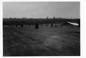
Forest Lawn Cemetery
https://search.heritageburnaby.ca/link/archivedescription93709
- Repository
- City of Burnaby Archives
- Date
- June 4, 1978
- Collection/Fonds
- Burnaby Public Library Contemporary Visual Archive Project
- Description Level
- Item
- Physical Description
- 1 photograph : b&w ; 12.5 x 17.5 cm
- Scope and Content
- Photograph of the grounds of the Forest Lawn Memorial Park cemetery, located by Royal Oak Avenue and Canada Way. Shrubs, gravestones, and a tent are across the lawn. The photograph is taken from on the grounds, facing south. High-rise buildings in the Metrotown area are visible in the distance.
- Repository
- City of Burnaby Archives
- Date
- June 4, 1978
- Collection/Fonds
- Burnaby Public Library Contemporary Visual Archive Project
- Physical Description
- 1 photograph : b&w ; 12.5 x 17.5 cm
- Description Level
- Item
- Record No.
- 556-666
- Access Restriction
- No restrictions
- Reproduction Restriction
- Reproduce for fair dealing purposes only
- Accession Number
- 2017-57
- Scope and Content
- Photograph of the grounds of the Forest Lawn Memorial Park cemetery, located by Royal Oak Avenue and Canada Way. Shrubs, gravestones, and a tent are across the lawn. The photograph is taken from on the grounds, facing south. High-rise buildings in the Metrotown area are visible in the distance.
- Subjects
- Monuments - Gravestones
- Cemeteries
- Media Type
- Photograph
- Photographer
- Surridge, Jack
- Notes
- Title taken from project information form
- Accompanied by a project information form and 1 photograph (b&w negative ; 9.5 x 12.5 cm)
- BPL no. 113
- Geographic Access
- Royal Oak Avenue
- Street Address
- 3789 Royal Oak Avenue
- Historic Neighbourhood
- Burnaby Lake (Historic Neighbourhood)
- Planning Study Area
- Douglas-Gilpin Area
Images

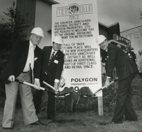
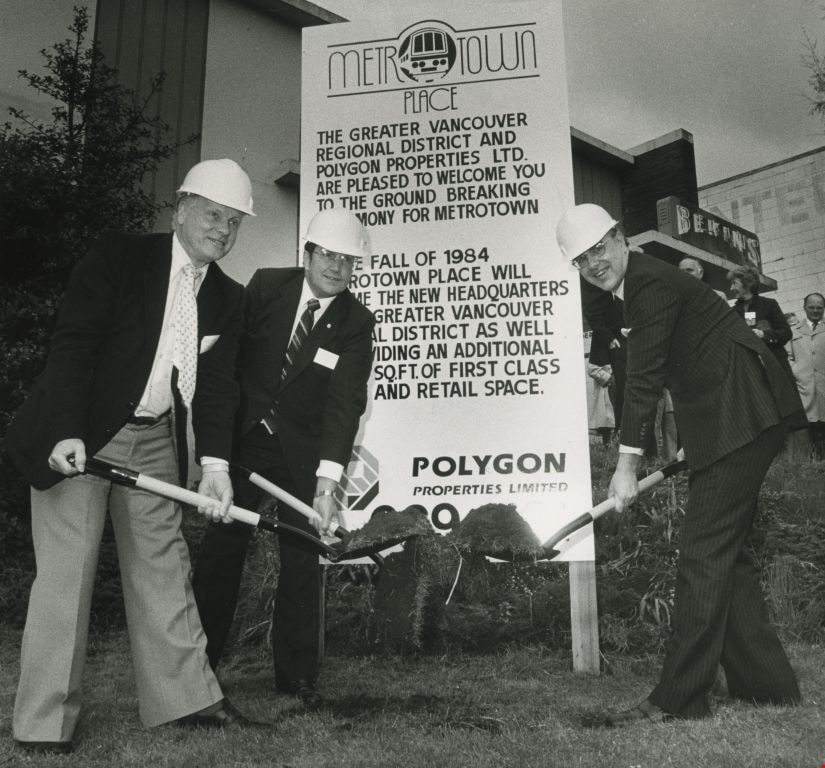
Mayor Bill Lewarne, Jim Tonn and Michael Audain
https://search.heritageburnaby.ca/link/archivedescription45386
- Repository
- City of Burnaby Archives
- Date
- 1983
- Collection/Fonds
- Columbian Newspaper collection
- Description Level
- Item
- Physical Description
- 1 photograph : b&w ; 19 x 20.5 cm
- Scope and Content
- Photograph of Burnaby Mayor Bill Lewarne, Jim Tonn from the Greater Vancouver Regional District (now Metro Vancouver), and the President of Polygon Michael Audain each with a shovel full of dirt at the ground breaking ceremony for Metrotown Place, the new headquaters for the Greater Vancouver Regio…
- Repository
- City of Burnaby Archives
- Date
- 1983
- Collection/Fonds
- Columbian Newspaper collection
- Physical Description
- 1 photograph : b&w ; 19 x 20.5 cm
- Description Level
- Item
- Record No.
- 480-281
- Access Restriction
- No restrictions
- Reproduction Restriction
- No restrictions
- Accession Number
- 2003-02
- Scope and Content
- Photograph of Burnaby Mayor Bill Lewarne, Jim Tonn from the Greater Vancouver Regional District (now Metro Vancouver), and the President of Polygon Michael Audain each with a shovel full of dirt at the ground breaking ceremony for Metrotown Place, the new headquaters for the Greater Vancouver Regional District (now Metro Vancouver).
- Media Type
- Photograph
- Photographer
- Battistoni, Peter
- Notes
- Title based on contents of photograph
- Geographic Access
- Kingsway
- Street Address
- 4330 Kingsway
- Historic Neighbourhood
- Central Park (Historic Neighbourhood)
- Planning Study Area
- Maywood Area
Images
Metrotown: Burnaby Heritage Resource Inventory
https://search.heritageburnaby.ca/link/archivedescription98239
- Repository
- City of Burnaby Archives
- Date
- 1986
- Collection/Fonds
- Burnaby Historical Society fonds
- Description Level
- File
- Physical Description
- 4 cm of textual records and 171 photographs : col. and b&w ; 9 cm x 17 cm and smaller
- Scope and Content
- File contains the galley proof of "Metrotown: Burnaby Heritage Resource Inventory" published by the Burnaby Historical Society in Summer 1986. The publication text, captions, and photographs are adhered to the inventory's pages. File also contains an invoice and receipt from Budget Printing for 25…
- Repository
- City of Burnaby Archives
- Date
- 1986
- Collection/Fonds
- Burnaby Historical Society fonds
- Subseries
- Ephemera subseries
- Physical Description
- 4 cm of textual records and 171 photographs : col. and b&w ; 9 cm x 17 cm and smaller
- Description Level
- File
- Record No.
- MSS204-001
- Access Restriction
- No restrictions
- Reproduction Restriction
- May be restricted by third party rights
- Accession Number
- 2019-09
- Scope and Content
- File contains the galley proof of "Metrotown: Burnaby Heritage Resource Inventory" published by the Burnaby Historical Society in Summer 1986. The publication text, captions, and photographs are adhered to the inventory's pages. File also contains an invoice and receipt from Budget Printing for 25 copies of the publications.
- Subjects
- Buildings - Residential - Houses
- Media Type
- Textual Record
- Photograph
- Notes
- Title based on contents of file
- Historic Neighbourhood
- Central Park (Historic Neighbourhood)

Metrotown
https://search.heritageburnaby.ca/link/landmark817
- Repository
- Burnaby Heritage Planning
- Geographic Access
- Kingsway
- Associated Dates
- 1986
- Heritage Value
- Although the idea for Metrotown was first expressed in the 1970s, the building itself opened in 1986 and was soon served by the Expo Line of the new SkyTrain system. In the ensuing twenty years, the complex developed into three distinct but adjoining malls - Metropolis at Metrotown, Metrotown Centre, and Station Square. Today, Metrotown serves as the city’s commercial and retail anchor. The mall also includes two large office towers, which by 2001 were home to the head offices for Shaw Cable and TransLink.
- Historic Neighbourhood
- Central Park (Historic Neighbourhood)
- Planning Study Area
- Maywood Area
- Street Address
- 4700 Kingsway
- Street View URL
- Google Maps Street View
Images

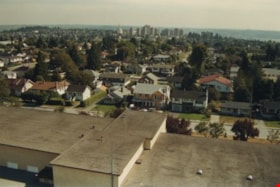
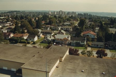
Edmonds school rooftop
https://search.heritageburnaby.ca/link/archivedescription35958
- Repository
- City of Burnaby Archives
- Date
- December 1987
- Collection/Fonds
- Burnaby Historical Society fonds
- Description Level
- Item
- Physical Description
- 1 photograph : col. ; 10 x 15 cm
- Scope and Content
- Photograph was taken looking south from a fire ladder above Edmonds Street School, with the school's rooftop as well as its surounding neighbourhood visible. Metrotown is in the distance.
- Repository
- City of Burnaby Archives
- Date
- December 1987
- Collection/Fonds
- Burnaby Historical Society fonds
- Subseries
- Edmonds School subseries
- Physical Description
- 1 photograph : col. ; 10 x 15 cm
- Description Level
- Item
- Record No.
- 207-007
- Access Restriction
- No restrictions
- Reproduction Restriction
- Reproduce for fair dealing purposes only
- Accession Number
- BHS1988-07
- Scope and Content
- Photograph was taken looking south from a fire ladder above Edmonds Street School, with the school's rooftop as well as its surounding neighbourhood visible. Metrotown is in the distance.
- Subjects
- Geographic Features - Neighbourhoods
- Media Type
- Photograph
- Notes
- Title based on contents of photograph
- Geographic Access
- 18th Avenue
- Street Address
- 7651 18th Avenue
- Historic Neighbourhood
- Edmonds (Historic Neighbourhood)
- Planning Study Area
- Edmonds Area
Images