Narrow Results By
Subject
- Advertising Medium 5
- Advertising Medium - Flyer 4
- Buildings 1
- Buildings - Commercial 1
- Buildings - Commercial - Restaurants 2
- Celebrations 1
- Celebrations - Centennials 5
- Clothing - Accessory 1
- Clothing - Uniforms 1
- Documentary Artifacts 17
- Documentary Artifacts - Booklets 6
- Documentary Artifacts - Leaflets 5
Person / Organization
- BC Society of Model Engineers (BCSME) 1
- Boy Scouts of Canada 1
- Burnaby Centennial '71 Committee 4
- Burnaby Civil Defence 1
- Burnaby Parks and Recreation Commission 1
- Burnaby Village Museum 23
- Canada Summer Games 1
- Century Park Museum Association 7
- Copan, Donald Angus "Don" 1
- Girl Guides of Canada 2
- Kingsway West School 1
- Pitman, Dorothy 1
Burnaby Zoning Bylaw Maps # 1 - 18
https://search.heritageburnaby.ca/link/archivedescription10004
- Repository
- City of Burnaby Archives
- Date
- 1965
- Collection/Fonds
- City Council and Office of the City Clerk fonds
- Description Level
- Item
- Physical Description
- Architectural drawing ; 180cm x 44cm (18 pages)
- Scope and Content
- Burnaby Zoning maps for Zoning Bylaw 1965
- Repository
- City of Burnaby Archives
- Date
- 1965
- Collection/Fonds
- City Council and Office of the City Clerk fonds
- Series
- Zoning and Rezoning series
- Physical Description
- Architectural drawing ; 180cm x 44cm (18 pages)
- Description Level
- Item
- Record No.
- 12970
- Accession Number
- 2002-07
- Scope and Content
- Burnaby Zoning maps for Zoning Bylaw 1965
- Media Type
- Architectural Drawing
leaflet
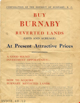
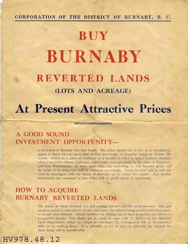
https://search.heritageburnaby.ca/link/museumartifact18096
- Repository
- Burnaby Village Museum
- Accession Code
- HV978.48.12
- Description
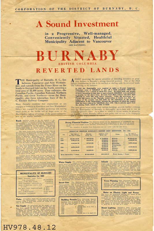
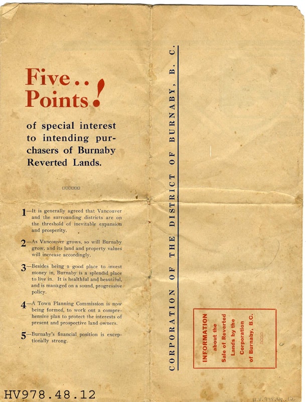
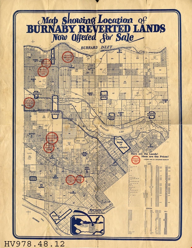
- Buy Burnaby Reverted Lands - Leaflet -- [192-]. Advertising leaflet for Burnaby Reverted Lands produced by the Corporation of the District of Burnaby B.C.. The leaflet explains the attraction to Burnaby and the good investment opportunity that it provides. It provides statistics from 1925 as to the financial position and property taxes. There is also a map outlining the land available for purchase.
- Subjects
- Documentary Artifacts
- Documentary Artifacts - Leaflets
- Documentary Artifacts - Maps
- Advertising Medium
- Advertising Medium - Flyer
Images


map
https://search.heritageburnaby.ca/link/museumartifact35811
- Repository
- Burnaby Village Museum
- Accession Code
- BV993.12.25
- Description
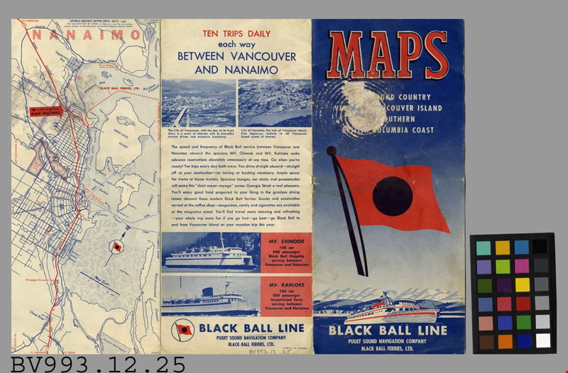
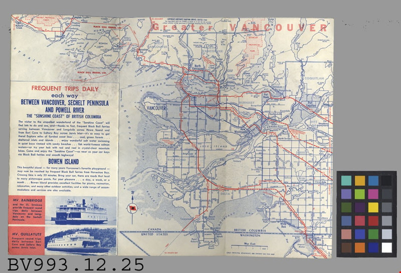
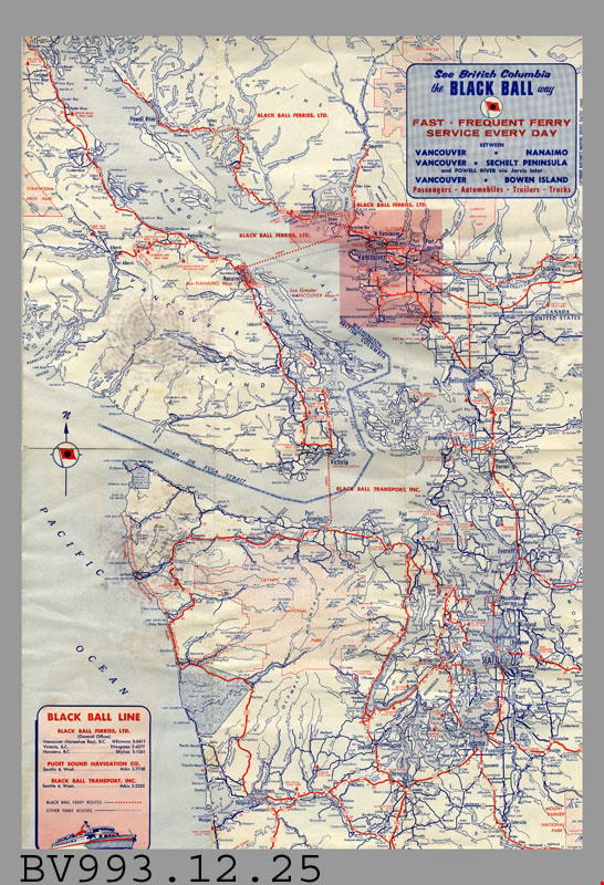
- Black Ball Line - Leaflet -- [1961]. Map leaflet for the Black Ball Line operated by Puget Sound Navigation Company and Black Ball Ferries Limited. The leaflet provides maps and information about the various trips that the company makes. The main routes appear to be between Vancouver and Nanaimo, Sechelt Peninsula, Powell River and Bowen Island. The leaflet measures 10cm x 23cm when closed.
- Title
- Maps
- Subjects
- Documentary Artifacts
- Documentary Artifacts - Leaflets
- Documentary Artifacts - Maps
- Transportation
- Transportation - Ferries
Images
map
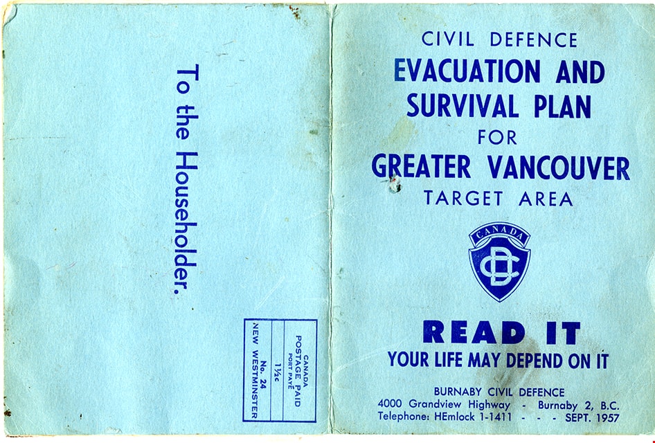
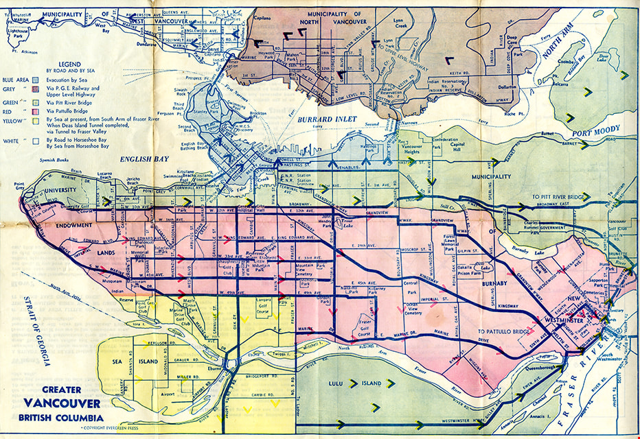
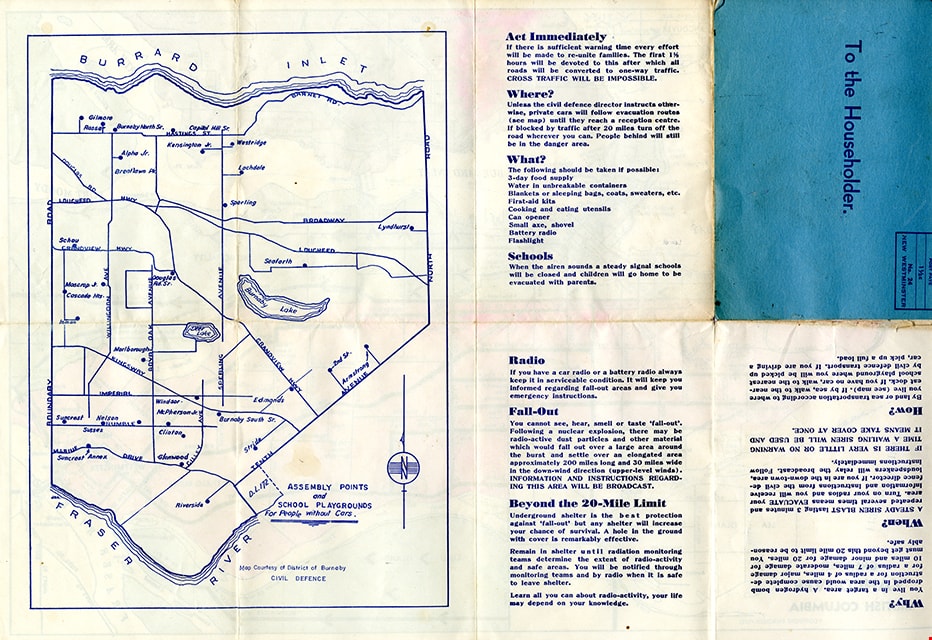
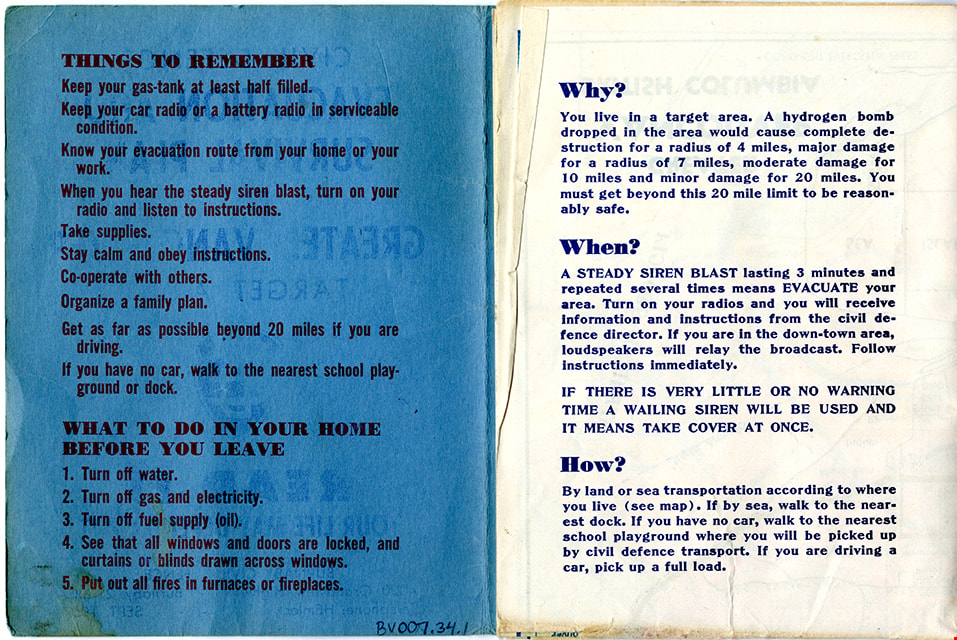
https://search.heritageburnaby.ca/link/museumartifact83653
- Repository
- Burnaby Village Museum
- Accession Code
- BV007.34.1
- Description
- Folded col. map within blue cover; printed both sides; Civil Defence Evacuation and Survival Plan - Map -- [1957] produced by Burnaby Civil Defence; title on front cover reads "CIVIL DEFENCE / EVACUATION AND SURVIVAL PLAN /FOR / GREATER VANCOUVER / TARGET AREA / READ IT / YOUR LIFE MAY DEPEND ON IT". Colour map inside is titled "GREATER / VANCOUVER / BRITISH COLUMBIA" and includes a legend with various evacuation routes by road and by sea; copyright Evergreen Press. Verso of map includes a map of Burnaby courtesy of District of Burnaby Civil Defence titled "ASSEMBLY POINTS / and / SCHOOL PLAYGROUNDS / for People without Cars" and detailed information about things to remember during an emergency evacuation.
- Object History
- Map was made available to citizens of Burnaby and was produced by Burnaby Civil Defence, 4000 Grandview Highway, Burnaby B.C.
- Category
- 08. Communication Artifacts
- Classification
- Documentary Artifacts - - Graphic Documents
- Object Term
- Cartograph, Map
- Colour
- Blue
- Measurements
- 30.5 x 34 cm folded to 15 x 11.5 cm
- Maker
- Evergreen Press Limited
- Country Made
- Canada
- Province Made
- British Columbia
- Publication Date
- Sept. 1957
- Names
- Burnaby Civil Defence
Images
map
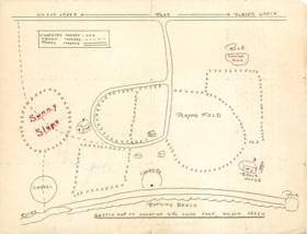
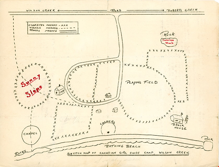
https://search.heritageburnaby.ca/link/museumartifact87474
- Repository
- Burnaby Village Museum
- Accession Code
- BV015.35.83
- Description
- map; "SKETCH MAP OF CANADIAN GIRL GUIDE CAMP, WILSON CREEK"; hand-drawn map shows locations of campsites, trails, roads, bathing beach, chapel, playing field, etc.; back of map has text in brown ink reading: "Over the hill and / down the valley" and Over the ill & do"
- Object History
- Map belonged to Dorothy Pitman who was a Girl Guide in the 1st Burnaby Company. She was known to be involved with guiding from 1919 to 1931. Textual records and photographs of the Pitman family, including one of Dorothy and her sister Gwen, are held by the City of Burnaby Archives. Dorothy and Gwen's parents, Ernest and Jean Pitman, owned McKay Dry Goods and Jubilee Dry Goods.
- Category
- 08. Communication Artifacts
- Classification
- Documentary Artifacts - - Graphic Documents
- Object Term
- Cartograph, Map
Images
map
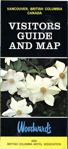
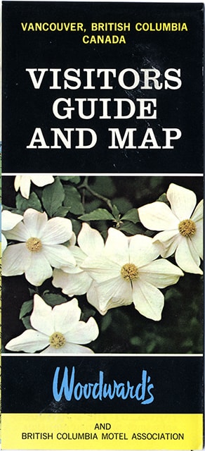
https://search.heritageburnaby.ca/link/museumartifact91126
- Repository
- Burnaby Village Museum
- Accession Code
- BV011.44.10
- Description
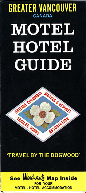
- map brochure; cover on one side reads "VANCOUVER, BRITISH COLUMBIA / CANADA / VISITORS / GUIDE / AND MAP" and the other side reads: "GREATER VANCOUVER / CANADA / MOTEL / HOTEL / GUIDE / TRAVEL BY THE DOGOOD'" and includes the logo for "British Columbia / Motels & Resorts / Trailer Parks / Association" with dogwood in centre. One side of fold-out includes map titled "Guide Map of Greater Vancouver / Woodwards" and includes inset map of Downtown Vancouver and Stanley Park and inset map of Lower Mainland and Fraser Valley Vancouver and Vicinity along with a list of Greater Vanouver Area Motels and Hotels. The other side of the fold-out includes colour adds for tourist sites and amenities in Greater Vancouver including Capilano Suspension bridge; Heritage Village, Burnaby, B.C.; MacMillan Planetarium; Bloedel Conservatory; Grouse Mountain; Gastown; The Ship of the Seven Seas restaurant and Woodwards stores and shopping centres. Map was published in the public interest by Woodward's (Lower Mainland) department stores; B.C. Motels and Resorts Association Branch "C" whose members appear on the map inside.
- Category
- 08. Communication Artifacts
- Classification
- Documentary Artifacts - - Graphic Documents
- Object Term
- Cartograph, Map
- Measurements
- 45.5 x 70 cm folded to 22.5 x 10 cm
- Country Made
- Canada
- Geographic Access
- Vancouver
Images
newsletter
https://search.heritageburnaby.ca/link/museumartifact84683
- Repository
- Burnaby Village Museum
- Accession Code
- BV011.55.1
- Description
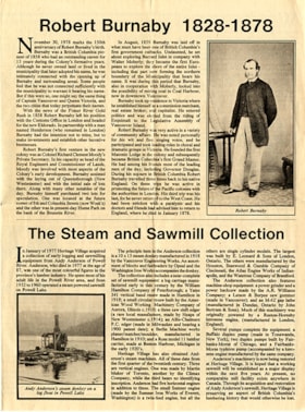
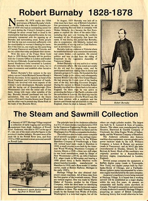
- Newsletter; created by Heritage Village Museum [1978]. Printed on newsprint, double sided, folded in centre. Newsletter also served as a map and guide of the village. The front page of the newsletter features articles "Robert Burnaby 1828 - 1878" and "The Steam and Sawmill Collection". The centre two pages open to a list of exhibits in the village with a site map. The back page includes "Operating Times"; "Heritage Village Calendar", and "Application for Membership" of the Century park Museum Association. Design and production by Dave Lovell.
- Object History
- Newsletter created by Heritage Village Museum (Burnaby Village Museum) and given out free to visitors. Design and production of the newsletter was created by Dave Lovell.
- Category
- 08. Communication Artifacts
- Classification
- Documentary Artifacts - - Other Documents
- Object Term
- Serial
- Colour
- Beige
- Measurements
- Height: 30 cm x Width: 44 cm folded to Height: 30 cm x Width: 22 cm
- Maker
- Heritage Village
- Country Made
- Canada
- Province Made
- British Columbia
- Site/City Made
- Burnaby
- Publication Date
- [1978]
Images
Documents
exercise book
https://search.heritageburnaby.ca/link/museumartifact41452
- Repository
- Burnaby Village Museum
- Accession Code
- BV001.1.226
- Description
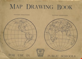
- Exercise book, "MAP DRAWING BOOK"; brown cover with black print; cover has two circles with "WESTERN HEMISPHERE" and "EASTERN HEMISPHERE" maps, "FOR USE IN PUBLIC SCHOOLS"; logo "MADE IN B.C.", "SWD"; back cover is blank; staplebound, staples are rusty; 5 blank pages of thick cream-coloured paper; three pages have maps hand drawn in pencil; first is Lower Mainland, with "E Bern" [Eburne?], similar map on back of page but with more details; next page has unlabelled map of North America; rest of pages are blank with stains and smudges; cover is soiled, creased, dog-eared; lower left corner of cover is torn and creased
- Colour
- Brown
- Country Made
- Canada
- Province Made
- British Columbia
- Title
- Map Drawing Book
Images

Ronald G. Scobbie collection
https://search.heritageburnaby.ca/link/museumdescription11914
- Repository
- Burnaby Village Museum
- Date
- [1890]-1932
- Collection/Fonds
- Ronald G. Scobbie collection
- Description Level
- Fonds
- Physical Description
- 55 plans + 2 architectural drawings + 1 map + graphic materials + 3 cm of textual records
- Scope and Content
- Fonds consists of survey and subdivision plans, a map and records created by Provincial Land Surveyors Albert J. Hill and Geoffrey K. Burnett and Donald Johnson McGugan and collected by Ronald G. Scobbie. Records include subdivision and survey plans in New Westminster District Group 1 including Dis…
- Repository
- Burnaby Village Museum
- Collection/Fonds
- Ronald G. Scobbie collection
- Description Level
- Fonds
- Physical Description
- 55 plans + 2 architectural drawings + 1 map + graphic materials + 3 cm of textual records
- Scope and Content
- Fonds consists of survey and subdivision plans, a map and records created by Provincial Land Surveyors Albert J. Hill and Geoffrey K. Burnett and Donald Johnson McGugan and collected by Ronald G. Scobbie. Records include subdivision and survey plans in New Westminster District Group 1 including District Lots in Burnaby along with various school sites and church plans; surveying records regarding North Road and a map of the Burnaby Municipality. Fonds is arranged into series: 1) Subdivision and survey plans series 2) School and church plans series 3) Map series
- History
- Ronald G. Scobbie was born in Scotland. After graduating from high school, he worked in the mines of Scotland which led to a career as a land surveyor. Ron immigrated to Canada in 1965 and settled in North Vancouver. In 1967 he became a partner in the surveying company of Hunter, Crockford & Scobbie in New Westminster, eventually owning it under the title Scobbie and Associates between 1980 and 1995. Ron sold the business in 1995 and retired as a BC Land Surveyor in December 2003. Ron was an active member of the B.C. Land Surveyors Association and an avid collector of surveying equipment and maps and plans that document the history of surveying in British Columbia. Upon retirement, Ron donated many historical maps and plans to various repositories located in different geographical regions throughout B.C.
- Scobbie & Associates land surveying company dates back to 1890 when Albert J. Hill first established his practice as a land surveyor in New Westminster. The company went through a series of Surveyors (owners) between 1890 and 1995:
- Albert James Hill (A.J. Hill) [1890] to 1912
- Hill & Burnett 1911 to 1912
- Geoffrey K. Burnett 1912
- Burnett & McGugan 1912 to 1947
- Burnett, McGugan & Hunter 1947 to 1959
- Burnett, Hunter & Douglas 1959 to 1960
- Hunter, Douglas & Crockford 1960 to 1964
- Hunter, Crockford & Associates 1964 to 1965
- Hunter, Crockford & Aplin 1965 to 1967
- Hunter, Crockford & Scobbie 1967 to 1973
- Crockford, Scobbie & Associates 1973-1980
- Scobbie & Associates 1980 to 1995
- Responsibility
- Scobbie, Ronald G.
- Accession Code
- HV984.57
- BV003.83
- Access Restriction
- No restrictions
- Reproduction Restriction
- No known restrictions
- Date
- [1890]-1932
- Related Material
- For other survey and subdivision plans created by land surveyors Albert J. Hill, Geoffery K. Burnett and Donald J. McGugan, see: Burnaby Village Museum Map collection - Survey and Subdivision plans series
- Notes
- Title based on contents of collection
B.C. Electric Railway Franchise - Agreement
https://search.heritageburnaby.ca/link/archivedescription382
- Repository
- City of Burnaby Archives
- Date
- 1909-1913
- Collection/Fonds
- City Council and Office of the City Clerk fonds
- Description Level
- File
- Physical Description
- Textual records and architectural drawings
- Scope and Content
- File contains records relating to agreements made between the Corporation of the District of Burnaby and the B.C. Electric Railway Co., for rail line extensions. File also includes a blueprint plan of station structures for Vancouver Fraser Valley and Southern Railway Co. and a newspaper clipping.
- Repository
- City of Burnaby Archives
- Date
- 1909-1913
- Collection/Fonds
- City Council and Office of the City Clerk fonds
- Physical Description
- Textual records and architectural drawings
- Description Level
- File
- Record No.
- 2075
- Accession Number
- 2001-02
- Scope and Content
- File contains records relating to agreements made between the Corporation of the District of Burnaby and the B.C. Electric Railway Co., for rail line extensions. File also includes a blueprint plan of station structures for Vancouver Fraser Valley and Southern Railway Co. and a newspaper clipping.
- Media Type
- Textual Record
- Architectural Drawing
- Notes
- Plans/maps are located in file and have not been moved to map case. File includes original newspaper clipping.
Board of Railway Commissioners
https://search.heritageburnaby.ca/link/archivedescription396
- Repository
- City of Burnaby Archives
- Date
- 1909-1912
- Collection/Fonds
- City Council and Office of the City Clerk fonds
- Description Level
- File
- Physical Description
- Textual record, cartographic material, and architectural drawings
- Scope and Content
- File contains correspondence and reports related to the activities of the Board of Railway Commissioners such as the movement of stations, culvert work, and the maintenance of crossings. File also includes white linen plan and blueprint plans (4) of culverts at Cariboo Road and V.W. and Y.Rlwy Jun…
- Repository
- City of Burnaby Archives
- Date
- 1909-1912
- Collection/Fonds
- City Council and Office of the City Clerk fonds
- Physical Description
- Textual record, cartographic material, and architectural drawings
- Description Level
- File
- Record No.
- 2096
- Accession Number
- 2001-02
- Scope and Content
- File contains correspondence and reports related to the activities of the Board of Railway Commissioners such as the movement of stations, culvert work, and the maintenance of crossings. File also includes white linen plan and blueprint plans (4) of culverts at Cariboo Road and V.W. and Y.Rlwy Junction, 1911.
- Notes
- Plans/maps are located in file and have not been moved to map case.
booklet
https://search.heritageburnaby.ca/link/museumartifact91128
- Repository
- Burnaby Village Museum
- Accession Code
- BV011.44.11
- Description
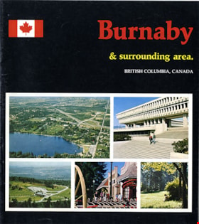
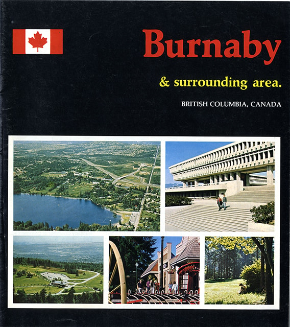
- guide booklet; glossy cover in black with colour photographs; stapled binding; pages within numbered 2-15 include colour photographs and maps. Front cover title reads "Burnaby / & surrounding area. / BRITISH COLUMBIA, CANADA" with a Canadian flag to the left of title and a grid of five colour photographs below including aerial view of Burnaby looking north from Deer Lake, Simon Fraser University, aerial view of Burnaby Mountain, Heritage Village Museum and a view of people beneath trees in a Burnaby park. Inside cover, page 2, includes "FACTS / ABOUT / BURNABY"; centre page includes map of Burnaby; page 12 includes map of British Columbia and the eastern section of Vancouver Island; page 13 title reads "SUGGESTED / SIDE TRIPS / FROM BURNABY". Back cover of booklet includes colour photograph of Burnaby Art Gallery and brief summary about Burnaby.
- Object History
- Published as a tourist brochure of tourist sites in and around Burnaby including Heritage Village (Burnaby Village Museum) on page 4. Collected by Century Park Museum Association and Heritage Village as part of their promotional materials.
- Category
- 08. Communication Artifacts
- Classification
- Documentary Artifacts - - Other Documents
- Object Term
- Pamphlet
- Measurements
- 23 cm x 20.5 cm
- Country Made
- Canada
- Province Made
- British Columbia
- Site/City Made
- Vancouver
- Title
- Burnaby and surrounding area
- Publication Date
- [1978]
- Names
- Burnaby Village Museum
- Geographic Access
- Vancouver
Images
Costs, tenders and other records for waterworks system for DL 186
https://search.heritageburnaby.ca/link/archivedescription388
- Repository
- City of Burnaby Archives
- Date
- 1910-1911
- Collection/Fonds
- City Council and Office of the City Clerk fonds
- Description Level
- File
- Physical Description
- Textual records and architectural drawing
- Scope and Content
- File contains records related to the installation of fire hydrants after the construction of waterworks station on DL 186. File also includes a blueprint diagram of a Slide Gate Fire Hydrant as well as costs, tenders and other reports and advertisements regarding types of equipment used during wate…
- Repository
- City of Burnaby Archives
- Date
- 1910-1911
- Collection/Fonds
- City Council and Office of the City Clerk fonds
- Physical Description
- Textual records and architectural drawing
- Description Level
- File
- Record No.
- 2081
- Accession Number
- 2001-02
- Scope and Content
- File contains records related to the installation of fire hydrants after the construction of waterworks station on DL 186. File also includes a blueprint diagram of a Slide Gate Fire Hydrant as well as costs, tenders and other reports and advertisements regarding types of equipment used during waterworks construction.
- Media Type
- Textual Record
- Architectural Drawing
- Notes
- For related records see also file 6-3-4-8 and file 6-3-5-1. Plans/maps are located in file and have not been moved to map case.
Ditches and water courses (Sprott)
https://search.heritageburnaby.ca/link/archivedescription668
- Repository
- City of Burnaby Archives
- Date
- 1908
- Collection/Fonds
- City Council and Office of the City Clerk fonds
- Description Level
- File
- Physical Description
- Textual records, cartographic material and architectural material
- Scope and Content
- File contains correspondence, certificates signed by the District Engineer attesting to the fact that ditches were constructed according to the Ditches and Waterworks Act, as well as notices to residents that ditches were to be built along their property. File also includes 2 blueprint plans and 1…
- Repository
- City of Burnaby Archives
- Date
- 1908
- Collection/Fonds
- City Council and Office of the City Clerk fonds
- Physical Description
- Textual records, cartographic material and architectural material
- Description Level
- File
- Record No.
- 2393
- Accession Number
- 2001-02
- Scope and Content
- File contains correspondence, certificates signed by the District Engineer attesting to the fact that ditches were constructed according to the Ditches and Waterworks Act, as well as notices to residents that ditches were to be built along their property. File also includes 2 blueprint plans and 1 linen map of DL 79.
- Notes
- Plans/maps are located in file and have not been moved to map case.
exercise book
https://search.heritageburnaby.ca/link/museumartifact41453
- Repository
- Burnaby Village Museum
- Accession Code
- BV001.1.227
- Description
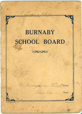
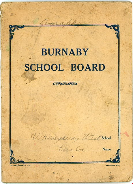
- Exercise book, buff cover, dark blue print; "BURNABY SCHOOL BOARD" inside border, dotted lines near bottom for "School" and "Name" have handwritten "(V / Kingsway West" and "Eric Coe"; printed below border is "COLUMBIA PAPER CO., LTD." "VANCOUVER, B.C."; handwritten above top border is "Geography"; soiled, spotted, creased; back cover is blank; staplebound, staples are rusty; ruled pages; geometrical drawing on first page, then map of South America; rest of book is written work and maps, from Feb.18 to June 14, 1921; most of book is unused
- Colour
- Beige
- Country Made
- Canada
- Province Made
- British Columbia
- Site/City Made
- Vancouver
- Title
- Burnaby School Board
- Publication Date
- 1921
- Names
- Kingsway West School
Images
Mortgage (Edmonds Development Co.)
https://search.heritageburnaby.ca/link/archivedescription905
- Repository
- City of Burnaby Archives
- Date
- 1912-1920
- Collection/Fonds
- City Council and Office of the City Clerk fonds
- Description Level
- File
- Physical Description
- Textual records and architectural drawing
- Scope and Content
- File contains correspondence, Council minutes, and an agreement made between the Corporation of the District of Burnaby and the Edmonds Development Co., Ltd., dealing with a mortgage for a building on Lot 8, blocks 1 and 3, DL 95. File also includes ink plans/sketches of a smokehouse for this buil…
- Repository
- City of Burnaby Archives
- Date
- 1912-1920
- Collection/Fonds
- City Council and Office of the City Clerk fonds
- Physical Description
- Textual records and architectural drawing
- Description Level
- File
- Record No.
- 2670
- Accession Number
- 2001-02
- Scope and Content
- File contains correspondence, Council minutes, and an agreement made between the Corporation of the District of Burnaby and the Edmonds Development Co., Ltd., dealing with a mortgage for a building on Lot 8, blocks 1 and 3, DL 95. File also includes ink plans/sketches of a smokehouse for this building which was purchased by City in 1918.
- Media Type
- Textual Record
- Architectural Drawing
- Notes
- For related records see 8-4-1-4. Plans/maps are located in file and have not been moved to map case.
Plans for new Municipal Hall
https://search.heritageburnaby.ca/link/archivedescription376
- Repository
- City of Burnaby Archives
- Date
- 1911-1913
- Collection/Fonds
- City Council and Office of the City Clerk fonds
- Description Level
- File
- Physical Description
- Textual records and architectural drawings
- Scope and Content
- File includes correspondence and other records related to the construction of a new municipal hall (Edmonds), 1911 to 1913. It includes a pencil sketch of jail beds, ink and watercolour drawing of "Back and Canopy for Seat in Court Room" (1912), and a blueprint of "Lamp at Municipal Hall."
- Repository
- City of Burnaby Archives
- Date
- 1911-1913
- Collection/Fonds
- City Council and Office of the City Clerk fonds
- Physical Description
- Textual records and architectural drawings
- Description Level
- File
- Record No.
- 2069
- Accession Number
- 2001-02
- Scope and Content
- File includes correspondence and other records related to the construction of a new municipal hall (Edmonds), 1911 to 1913. It includes a pencil sketch of jail beds, ink and watercolour drawing of "Back and Canopy for Seat in Court Room" (1912), and a blueprint of "Lamp at Municipal Hall."
- Media Type
- Textual Record
- Architectural Drawing
- Notes
- Plans/maps are located in file and have not been moved to map case.
Pound, blacksmith and carpenter shops
https://search.heritageburnaby.ca/link/archivedescription237
- Repository
- City of Burnaby Archives
- Date
- 1911
- Collection/Fonds
- City Council and Office of the City Clerk fonds
- Description Level
- File
- Physical Description
- Textual record and architectural material
- Scope and Content
- File includes 1911 sketch plans and a cost estimate for a proposed pound, smithy and carpenters shop for the Municipal Hall grounds.
- Repository
- City of Burnaby Archives
- Date
- 1911
- Collection/Fonds
- City Council and Office of the City Clerk fonds
- Physical Description
- Textual record and architectural material
- Description Level
- File
- Record No.
- 1926
- Accession Number
- 2001-02
- Scope and Content
- File includes 1911 sketch plans and a cost estimate for a proposed pound, smithy and carpenters shop for the Municipal Hall grounds.
- Media Type
- Textual Record
- Architectural Drawing
- Notes
- This file is referred to in the Council Minute book, page 84 line 34. For related records see also files 6-4-4-2 and 6-4-5-2 and 7-3-2-14. Plans/maps are located in file and have not been moved to map case.
West Burnaby sewerage correspondence
https://search.heritageburnaby.ca/link/archivedescription1364
- Repository
- City of Burnaby Archives
- Date
- 1926-1928
- Collection/Fonds
- City Council and Office of the City Clerk fonds
- Description Level
- File
- Physical Description
- Textual records and architectural drawings
- Scope and Content
- File includes an ink on white linen table titled "West Burnaby Sewers, Tabulation of Bids", and a blueprint of the same. Also included is an ink on white linen plan with some notations in pencil (1927)
- Repository
- City of Burnaby Archives
- Date
- 1926-1928
- Collection/Fonds
- City Council and Office of the City Clerk fonds
- Physical Description
- Textual records and architectural drawings
- Description Level
- File
- Record No.
- 3171
- Accession Number
- 2001-02
- Scope and Content
- File includes an ink on white linen table titled "West Burnaby Sewers, Tabulation of Bids", and a blueprint of the same. Also included is an ink on white linen plan with some notations in pencil (1927)
- Media Type
- Textual Record
- Architectural Drawing
- Notes
- Plans/maps are located in file and have not been moved to map case.

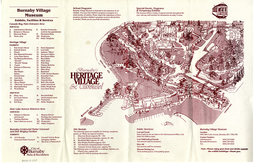
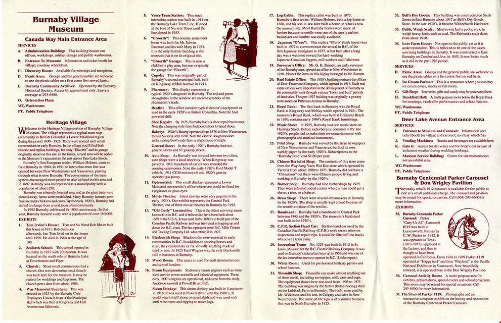
map
https://search.heritageburnaby.ca/link/museumartifact91044
- Repository
- Burnaby Village Museum
- Accession Code
- BV020.5.1769
- Description
- Map; site Map printed on beige paper with burgundy ink; four section accordian fold; front includes site Map of Burnaby Village Museum with title "Burnaby's / HERITAGE / VILLAGE / & Carousel"; lists exhibits, facilities and services; back of Map includes detailed descriptions of services and exhibits along with three in line illustrations.
- Object History
- Item was found in Burnaby Village Museum printshop along with other Heritage Village / Burnaby Village Museum ephemera created between 1971 and 1990
- Category
- 08. Communication Artifacts
- Classification
- Documentary Artifacts - - Other Documents
- Object Term
- Cartograph, Map
- Measurements
- 28 x 43 cm
- Country Made
- Canada
- Province Made
- British Columbia
- Publication Date
- [1994]
- Subjects
- Documentary Artifacts
- Names
- Burnaby Village Museum
Images