Narrow Results By
Subject
- Advertising Medium - Signs and Signboards 2
- Aerial Photographs 2
- Agricultural Tools and Equipment 1
- Animals - Cats 1
- Animals - Dogs 3
- Animals - Oxen 1
- Buildings - Commercial 8
- Buildings - Commercial - Automobile Dealerships 1
- Buildings - Heritage 1
- Buildings - Industrial 1
- Buildings - Industrial - Mills 1
- Buildings - Residences - Houses 1

Residents involved in protesting tree removal
https://search.heritageburnaby.ca/link/archivedescription78595
- Repository
- City of Burnaby Archives
- Date
- October 8, 1995
- Collection/Fonds
- Burnaby NewsLeader photograph collection
- Description Level
- Item
- Physical Description
- 1 photograph : b&w ; 16.5 x 24.5 cm
- Scope and Content
- Photograph of residents of Burnaby protesting the clearing of land around the Hong Kong Bank, in Discovery Park industrial site near British Columbia Institute of Technology (BCIT).
- Repository
- City of Burnaby Archives
- Date
- October 8, 1995
- Collection/Fonds
- Burnaby NewsLeader photograph collection
- Physical Description
- 1 photograph : b&w ; 16.5 x 24.5 cm
- Description Level
- Item
- Record No.
- 535-0011
- Access Restriction
- No restrictions
- Reproduction Restriction
- No reproduction permitted
- Accession Number
- 2012-11
- Scope and Content
- Photograph of residents of Burnaby protesting the clearing of land around the Hong Kong Bank, in Discovery Park industrial site near British Columbia Institute of Technology (BCIT).
- Names
- Chami, Parvin
- Media Type
- Photograph
- Photographer
- Ponne, Simone
- Notes
- Title based on contents of photograph
- Note in black ink on recto of photograph reads: "2764A Bby Ponne / Bby p. 1 81%"
- Trim marks and/or reproduction instructions on recto (scan is cropped)
- Geographic Access
- Willingdon Avenue
- Planning Study Area
- Douglas-Gilpin Area
Images

5548 Marshland Ave
https://search.heritageburnaby.ca/link/archivedescription94302
- Repository
- City of Burnaby Archives
- Date
- January 1994
- Collection/Fonds
- Grover, Elliott & Co. Ltd. fonds
- Description Level
- File
- Physical Description
- 25 photographs : col. negatives ; 35 mm
- Scope and Content
- Photographs of an undeveloped property located at 5548 Marshland Avenue - an address that no longer exists.
- Repository
- City of Burnaby Archives
- Date
- January 1994
- Collection/Fonds
- Grover, Elliott & Co. Ltd. fonds
- Physical Description
- 25 photographs : col. negatives ; 35 mm
- Description Level
- File
- Record No.
- 622-087
- Access Restriction
- No restrictions
- Reproduction Restriction
- No restrictions
- Accession Number
- 2017-39
- Scope and Content
- Photographs of an undeveloped property located at 5548 Marshland Avenue - an address that no longer exists.
- Subjects
- Land Clearing
- Media Type
- Photograph
- Notes
- Transcribed title
- Title transcribed from envelope photographs were originally housed in
- File no. 94-023-B
- Photographer identified as "K.D."
- Geographic Access
- Marshland Avenue
- Historic Neighbourhood
- Fraser Arm (Historic Neighbourhood)
- Planning Study Area
- Big Bend Area
7026 Kingsway
https://search.heritageburnaby.ca/link/archivedescription94304
- Repository
- City of Burnaby Archives
- Date
- January 1994
- Collection/Fonds
- Grover, Elliott & Co. Ltd. fonds
- Description Level
- File
- Physical Description
- 19 photographs : col. negatives ; 35 mm
- Scope and Content
- Photographs of commercial and undeveloped properties located in the 7100 block of Kingsway, including Middlegate Honda, with mid-rise towers visible in the background.
- Repository
- City of Burnaby Archives
- Date
- January 1994
- Collection/Fonds
- Grover, Elliott & Co. Ltd. fonds
- Physical Description
- 19 photographs : col. negatives ; 35 mm
- Description Level
- File
- Record No.
- 622-089
- Access Restriction
- No restrictions
- Reproduction Restriction
- No restrictions
- Accession Number
- 2017-39
- Scope and Content
- Photographs of commercial and undeveloped properties located in the 7100 block of Kingsway, including Middlegate Honda, with mid-rise towers visible in the background.
- Media Type
- Photograph
- Notes
- Transcribed title
- Title transcribed from envelope photographs were originally housed in
- File no. 94-028-B
- Photographer identified as "L.D."
- Geographic Access
- Kingsway
- Historic Neighbourhood
- Edmonds (Historic Neighbourhood)
- Planning Study Area
- Stride Avenue Area
5200 Oakmount Cr.
https://search.heritageburnaby.ca/link/archivedescription94313
- Repository
- City of Burnaby Archives
- Date
- June 1994
- Collection/Fonds
- Grover, Elliott & Co. Ltd. fonds
- Description Level
- File
- Physical Description
- 23 photographs : col. negatives ; 35 mm
- Scope and Content
- Photographs of an undeveloped property located at 5200 Oakmount Crescent - an address that no longer exists.
- Repository
- City of Burnaby Archives
- Date
- June 1994
- Collection/Fonds
- Grover, Elliott & Co. Ltd. fonds
- Physical Description
- 23 photographs : col. negatives ; 35 mm
- Description Level
- File
- Record No.
- 622-098
- Access Restriction
- No restrictions
- Reproduction Restriction
- No restrictions
- Accession Number
- 2017-39
- Scope and Content
- Photographs of an undeveloped property located at 5200 Oakmount Crescent - an address that no longer exists.
- Subjects
- Land Clearing
- Media Type
- Photograph
- Notes
- Transcribed title
- Title transcribed from envelope photographs were originally housed in
- File no. 94-236-B
- Photographer identified as "J.C."
- Geographic Access
- Oakmount Crescent
- Historic Neighbourhood
- Central Park (Historic Neighbourhood)
- Planning Study Area
- Windsor Area
4010 Regent St.
https://search.heritageburnaby.ca/link/archivedescription94318
- Repository
- City of Burnaby Archives
- Date
- September 1994
- Collection/Fonds
- Grover, Elliott & Co. Ltd. fonds
- Description Level
- File
- Physical Description
- 25 photographs : col. negatives ; 35 mm
- Scope and Content
- Photographs of an undeveloped property located at 4010 Regent Street. Property is covered with soil, brush, and some trees.
- Repository
- City of Burnaby Archives
- Date
- September 1994
- Collection/Fonds
- Grover, Elliott & Co. Ltd. fonds
- Physical Description
- 25 photographs : col. negatives ; 35 mm
- Description Level
- File
- Record No.
- 622-103
- Access Restriction
- No restrictions
- Reproduction Restriction
- No restrictions
- Accession Number
- 2017-39
- Scope and Content
- Photographs of an undeveloped property located at 4010 Regent Street. Property is covered with soil, brush, and some trees.
- Subjects
- Land Clearing
- Media Type
- Photograph
- Photographer
- Young, Richard
- Notes
- Transcribed title
- Title transcribed from envelope photographs were originally housed in
- File no. 94-342-B
- Geographic Access
- Regent Street
- Street Address
- 4010 Regent Street
- Historic Neighbourhood
- Broadview (Historic Neighbourhood)
- Planning Study Area
- West Central Valley Area
8980 Fraserwood Crt
https://search.heritageburnaby.ca/link/archivedescription94326
- Repository
- City of Burnaby Archives
- Date
- December 1994
- Collection/Fonds
- Grover, Elliott & Co. Ltd. fonds
- Description Level
- File
- Physical Description
- 24 photographs : col. negatives ; 35 mm
- Scope and Content
- Photographs of an undeveloped property located at 8980 Fraserwood Court. A Sutton Group real estate sign on the property advertises the site as the Fraserwood Corporate Centre with strata warehouse and office flex space. File also contains photographs of the commerical building adjacent to the si…
- Repository
- City of Burnaby Archives
- Date
- December 1994
- Collection/Fonds
- Grover, Elliott & Co. Ltd. fonds
- Physical Description
- 24 photographs : col. negatives ; 35 mm
- Description Level
- File
- Record No.
- 622-111
- Access Restriction
- No restrictions
- Reproduction Restriction
- No restrictions
- Accession Number
- 2017-39
- Scope and Content
- Photographs of an undeveloped property located at 8980 Fraserwood Court. A Sutton Group real estate sign on the property advertises the site as the Fraserwood Corporate Centre with strata warehouse and office flex space. File also contains photographs of the commerical building adjacent to the site.
- Media Type
- Photograph
- Notes
- Transcribed title
- Title transcribed from envelope photographs were originally housed in
- File no. 94-422-B
- Photographer identified as "L.D."
- Geographic Access
- Fraserwood Court
- Street Address
- 8980 Fraserwood Court
- Historic Neighbourhood
- Fraser Arm (Historic Neighbourhood)
- Planning Study Area
- Big Bend Area
1160 Douglas Rd
https://search.heritageburnaby.ca/link/archivedescription94327
- Repository
- City of Burnaby Archives
- Date
- December 1994
- Collection/Fonds
- Grover, Elliott & Co. Ltd. fonds
- Description Level
- File
- Physical Description
- 22 photographs : col. negatives ; 35 mm
- Scope and Content
- Photographs of the exterior of a three-storey commerical building located at 1160 Douglas Road.
- Repository
- City of Burnaby Archives
- Date
- December 1994
- Collection/Fonds
- Grover, Elliott & Co. Ltd. fonds
- Physical Description
- 22 photographs : col. negatives ; 35 mm
- Description Level
- File
- Record No.
- 622-112
- Access Restriction
- No restrictions
- Reproduction Restriction
- No restrictions
- Accession Number
- 2017-39
- Scope and Content
- Photographs of the exterior of a three-storey commerical building located at 1160 Douglas Road.
- Media Type
- Photograph
- Photographer
- Young, Richard
- Notes
- Transcribed title
- Title transcribed from envelope photographs were originally housed in
- File no. 94-424-B
- Geographic Access
- Douglas Road
- Street Address
- 1160 Douglas Road
- Historic Neighbourhood
- Vancouver Heights (Historic Neighbourhood)
- Planning Study Area
- Willingdon Heights Area
Burnaby centennial anthology : stories of early Burnaby
https://search.heritageburnaby.ca/link/museumlibrary5472
- Repository
- Burnaby Village Museum
- Edition
- Rev. ed.
- Publication Date
- 1994
- Call Number
- 971.133 BUR COPY 3
- Repository
- Burnaby Village Museum
- Collection
- Digital Reference Collection
- Material Type
- Book
- ISBN
- 0969282826
- Call Number
- 971.133 BUR COPY 3
- Edition
- Rev. ed.
- Place of Publication
- Burnaby, B.C.
- Publisher
- City of Burnaby
- Publication Date
- 1994
- Physical Description
- 531 p. : ill. ; 28 cm.
- Library Subject (LOC)
- Burnaby (B.C.)--History
- Burnaby (B.C.)
- Biography
- Notes
- Includes index.
- 3 copies held: copy 3.
Digital Books
Burnaby
https://search.heritageburnaby.ca/link/archivedescription93751
- Repository
- City of Burnaby Archives
- Date
- 1991
- Collection/Fonds
- Grover, Elliott & Co. Ltd. fonds
- Description Level
- File
- Physical Description
- 43 photographs : col. negatives ; 35 mm
- Scope and Content
- Photographs of the exterior of a single-storey industrial building and surrounding undeveloped property. A sign on the building reads "Bauer". The location of the building has not been identified.
- Repository
- City of Burnaby Archives
- Date
- 1991
- Collection/Fonds
- Grover, Elliott & Co. Ltd. fonds
- Physical Description
- 43 photographs : col. negatives ; 35 mm
- Description Level
- File
- Record No.
- 622-036
- Access Restriction
- No restrictions
- Reproduction Restriction
- No restrictions
- Accession Number
- 2017-39
- Scope and Content
- Photographs of the exterior of a single-storey industrial building and surrounding undeveloped property. A sign on the building reads "Bauer". The location of the building has not been identified.
- Subjects
- Buildings - Industrial
- Land Clearing
- Media Type
- Photograph
- Notes
- Transcribed title
- Title transcribed from envelope photographs were originally housed in
- File no. 91-452-B
8855 Northbrook Court
https://search.heritageburnaby.ca/link/archivedescription93735
- Repository
- City of Burnaby Archives
- Date
- 1989
- Collection/Fonds
- Grover, Elliott & Co. Ltd. fonds
- Description Level
- File
- Physical Description
- 21 photographs : col. negatives ; 35 mm
- Scope and Content
- Photographs of an undeveloped property loacated at 8855 Northbrook Court. Construction equipment is visible in the distance.
- Repository
- City of Burnaby Archives
- Date
- 1989
- Collection/Fonds
- Grover, Elliott & Co. Ltd. fonds
- Physical Description
- 21 photographs : col. negatives ; 35 mm
- Description Level
- File
- Record No.
- 622-020
- Access Restriction
- No restrictions
- Reproduction Restriction
- No restrictions
- Accession Number
- 2017-39
- Scope and Content
- Photographs of an undeveloped property loacated at 8855 Northbrook Court. Construction equipment is visible in the distance.
- Media Type
- Photograph
- Notes
- Transcribed title
- Title transcribed from original print envelope
- File no. 89-037-B
- Geographic Access
- Northbrook Court
- Street Address
- 8855 Northbrook Court
- Historic Neighbourhood
- Fraser Arm (Historic Neighbourhood)
- Planning Study Area
- Big Bend Area
North Fraser Way / Northbrook Court
https://search.heritageburnaby.ca/link/archivedescription93736
- Repository
- City of Burnaby Archives
- Date
- 1989
- Collection/Fonds
- Grover, Elliott & Co. Ltd. fonds
- Description Level
- File
- Physical Description
- 16 photographs : col. negatives ; 35 mm
- Scope and Content
- Photographs of an undeveloped property loacated at the corner of North Fraser Way and Northbrook Court.
- Repository
- City of Burnaby Archives
- Date
- 1989
- Collection/Fonds
- Grover, Elliott & Co. Ltd. fonds
- Physical Description
- 16 photographs : col. negatives ; 35 mm
- Description Level
- File
- Record No.
- 622-021
- Access Restriction
- No restrictions
- Reproduction Restriction
- No restrictions
- Accession Number
- 2017-39
- Scope and Content
- Photographs of an undeveloped property loacated at the corner of North Fraser Way and Northbrook Court.
- Subjects
- Land Clearing
- Geographic Features - Roads
- Media Type
- Photograph
- Notes
- Transcribed title
- Title transcribed from original print envelope
- File no. 89-040-B
- Geographic Access
- Northbrook Court
- North Fraser Way
- Historic Neighbourhood
- Fraser Arm (Historic Neighbourhood)
- Planning Study Area
- Big Bend Area
Halifax / Buchanon, Bby
https://search.heritageburnaby.ca/link/archivedescription93743
- Repository
- City of Burnaby Archives
- Date
- 1989
- Collection/Fonds
- Grover, Elliott & Co. Ltd. fonds
- Description Level
- File
- Physical Description
- 25 photographs : col. negatives ; 35 mm
- Scope and Content
- Photographs of a property located between Halifax Street and Buchanon Street under construction.
- Repository
- City of Burnaby Archives
- Date
- 1989
- Collection/Fonds
- Grover, Elliott & Co. Ltd. fonds
- Physical Description
- 25 photographs : col. negatives ; 35 mm
- Description Level
- File
- Record No.
- 622-028
- Access Restriction
- No restrictions
- Reproduction Restriction
- No restrictions
- Accession Number
- 2017-39
- Scope and Content
- Photographs of a property located between Halifax Street and Buchanon Street under construction.
- Media Type
- Photograph
- Notes
- Transcribed title
- Title transcribed from print envelope photographs were originally housed in
- File no. 89-390-B
- Handwritten sticky note on print envelope reads: "BOSA - Burnaby Office". At time of description, Bosa Development's Burnaby office is located at 1300-2025 Willingdon Avenue.
- Historic Neighbourhood
- Vancouver Heights (Historic Neighbourhood)
- Planning Study Area
- Willingdon Heights Area
Lot 1 Galglardi [sic] Way
https://search.heritageburnaby.ca/link/archivedescription93746
- Repository
- City of Burnaby Archives
- Date
- 1989
- Collection/Fonds
- Grover, Elliott & Co. Ltd. fonds
- Description Level
- File
- Physical Description
- 22 photographs : col. negatives ; 35 mm
- Scope and Content
- Photographs of an undeveloped property located on Gaglardi Way and overpass.
- Repository
- City of Burnaby Archives
- Date
- 1989
- Collection/Fonds
- Grover, Elliott & Co. Ltd. fonds
- Physical Description
- 22 photographs : col. negatives ; 35 mm
- Description Level
- File
- Record No.
- 622-031
- Access Restriction
- No restrictions
- Reproduction Restriction
- No restrictions
- Accession Number
- 2017-39
- Scope and Content
- Photographs of an undeveloped property located on Gaglardi Way and overpass.
- Subjects
- Land Clearing
- Media Type
- Photograph
- Notes
- Transcribed title
- Title transcribed from print envelopes photographs were originally housed in
- File no. 89-515-B
- Geographic Access
- Gaglardi Way
Marine Way
https://search.heritageburnaby.ca/link/archivedescription93716
- Repository
- City of Burnaby Archives
- Date
- 1987
- Collection/Fonds
- Grover, Elliott & Co. Ltd. fonds
- Description Level
- File
- Physical Description
- 24 photographs : col. negatives ; 35 mm
- Scope and Content
- Photographs of an undeveloped property along Marine Way. Property is located adjacent to railway tracks and a creek.
- Repository
- City of Burnaby Archives
- Date
- 1987
- Collection/Fonds
- Grover, Elliott & Co. Ltd. fonds
- Physical Description
- 24 photographs : col. negatives ; 35 mm
- Description Level
- File
- Record No.
- 622-005
- Access Restriction
- No restrictions
- Reproduction Restriction
- No restrictions
- Accession Number
- 2017-39
- Scope and Content
- Photographs of an undeveloped property along Marine Way. Property is located adjacent to railway tracks and a creek.
- Media Type
- Photograph
- Notes
- Transcribed title
- Title transcribed from original print envelope
- File no. 87-297-B
- Geographic Access
- Marine Way
- Historic Neighbourhood
- Fraser Arm (Historic Neighbourhood)
- Planning Study Area
- Big Bend Area

Former site of the Kelly Douglas building
https://search.heritageburnaby.ca/link/archivedescription35027
- Repository
- City of Burnaby Archives
- Date
- August 18, 1986
- Collection/Fonds
- Burnaby Historical Society fonds
- Description Level
- Item
- Physical Description
- 1 photograph : col. ; 8.8 x 12.6 cm
- Scope and Content
- Photograph of the site of Kelly Douglas and Co. at 4700 Kingsway after the building was demolished. A bulldozer and a large truck with two men standing on it are at the back left of the photograph.
- Repository
- City of Burnaby Archives
- Date
- August 18, 1986
- Collection/Fonds
- Burnaby Historical Society fonds
- Subseries
- Evelyn Salisbury subseries
- Physical Description
- 1 photograph : col. ; 8.8 x 12.6 cm
- Material Details
- Printed on verso of photograph: "This paper manufactured by Kodak"
- Description Level
- Item
- Record No.
- 178-001
- Access Restriction
- No restrictions
- Reproduction Restriction
- Reproduce for fair dealing purposes only
- Accession Number
- BHS1986-26
- Scope and Content
- Photograph of the site of Kelly Douglas and Co. at 4700 Kingsway after the building was demolished. A bulldozer and a large truck with two men standing on it are at the back left of the photograph.
- Media Type
- Photograph
- Notes
- Title based on contents of photograph
- Geographic Access
- Kingsway
- Street Address
- 4700 Kingsway
- Historic Neighbourhood
- Central Park (Historic Neighbourhood)
- Planning Study Area
- Maywood Area
Images


6113 Silver Avenue lot
https://search.heritageburnaby.ca/link/archivedescription37775
- Repository
- City of Burnaby Archives
- Date
- 1986 (date of original), copied 1991
- Collection/Fonds
- Burnaby Historical Society fonds
- Description Level
- Item
- Physical Description
- 1 photograph : b&w ; 3.1 x 4.4 cm print on contact sheet 20.3 x 26.2 cm
- Scope and Content
- Photograph of the lot at 6113 Silver Avenue, the former home of the Ellis family. The house has been demolished and an empty lot remains. Houses, aparment buildings, and the Expo line skytrain track with cars on it can be seen in the background.
- Repository
- City of Burnaby Archives
- Date
- 1986 (date of original), copied 1991
- Collection/Fonds
- Burnaby Historical Society fonds
- Subseries
- Burnaby Image Bank subseries
- Physical Description
- 1 photograph : b&w ; 3.1 x 4.4 cm print on contact sheet 20.3 x 26.2 cm
- Description Level
- Item
- Record No.
- 370-363
- Access Restriction
- No restrictions
- Reproduction Restriction
- No restrictions
- Accession Number
- BHS1999-03
- Scope and Content
- Photograph of the lot at 6113 Silver Avenue, the former home of the Ellis family. The house has been demolished and an empty lot remains. Houses, aparment buildings, and the Expo line skytrain track with cars on it can be seen in the background.
- Subjects
- Land Clearing
- Media Type
- Photograph
- Notes
- Title based on contents of photograph
- 1 b&w copy negative accompanying
- Negative has a pink cast
- Copied from col. photograph
- Geographic Access
- Silver Avenue
- Street Address
- 6113 Silver Avenue
- Historic Neighbourhood
- Central Park (Historic Neighbourhood)
- Planning Study Area
- Maywood Area
Images


Widening of Scott Road
https://search.heritageburnaby.ca/link/archivedescription56677
- Repository
- City of Burnaby Archives
- Date
- March 1976, published March 24, 1976
- Collection/Fonds
- Columbian Newspaper collection
- Description Level
- Item
- Physical Description
- 1 photograph : b&w ; 7.5 x 14 cm
- Scope and Content
- Photograph of the process of widening Scott Road in Surrey BC. The process was undertaken by the provincial government. Citizens were upset as this process included cutting down century-old trees (stumps of these former trees are visible in this photograph).
- Repository
- City of Burnaby Archives
- Date
- March 1976, published March 24, 1976
- Collection/Fonds
- Columbian Newspaper collection
- Physical Description
- 1 photograph : b&w ; 7.5 x 14 cm
- Description Level
- Item
- Record No.
- 480-531
- Access Restriction
- No restrictions
- Reproduction Restriction
- No restrictions
- Accession Number
- 2003-02
- Scope and Content
- Photograph of the process of widening Scott Road in Surrey BC. The process was undertaken by the provincial government. Citizens were upset as this process included cutting down century-old trees (stumps of these former trees are visible in this photograph).
- Media Type
- Photograph
- Photographer
- King, Basil
- Notes
- Title based on contents of photograph
- Newspaper clipping attached to verso of photograph reads: "Road-widening on Scott Rd. in Surrey has taken its toll of old trees."
Images

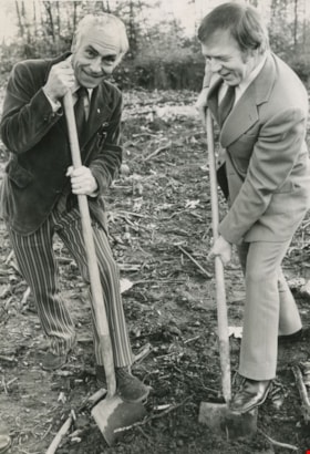
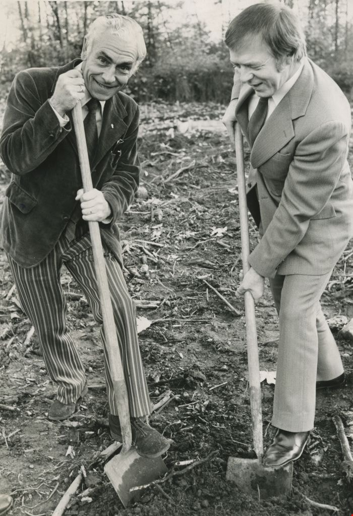
Tony Schmand with Mayor Tom Constable
https://search.heritageburnaby.ca/link/archivedescription45992
- Repository
- City of Burnaby Archives
- Date
- October 1973
- Collection/Fonds
- Columbian Newspaper collection
- Description Level
- Item
- Physical Description
- 1 photograph : b&w ; 20.5 x 14 cm
- Scope and Content
- Photograph of British Columbia Association for the Mentally Retarded president Tony Schmand with Mayor Tom Constable performing the sod turning ceremony for the site of a facility to accomodate the developmentally challenged in Burnaby.
- Repository
- City of Burnaby Archives
- Date
- October 1973
- Collection/Fonds
- Columbian Newspaper collection
- Physical Description
- 1 photograph : b&w ; 20.5 x 14 cm
- Description Level
- Item
- Record No.
- 480-887
- Access Restriction
- No restrictions
- Reproduction Restriction
- Reproduce for fair dealing purposes only
- Accession Number
- 2003-02
- Scope and Content
- Photograph of British Columbia Association for the Mentally Retarded president Tony Schmand with Mayor Tom Constable performing the sod turning ceremony for the site of a facility to accomodate the developmentally challenged in Burnaby.
- Subjects
- Land Clearing
- Ceremonies
- Media Type
- Photograph
- Photographer
- Battistoni, Peter
- Notes
- Title based on contents of photograph
- Geographic Access
- Banff Avenue
Images
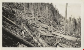
Felled trees
https://search.heritageburnaby.ca/link/archivedescription80591
- Repository
- City of Burnaby Archives
- Collection/Fonds
- Murray family fonds
- Description Level
- Item
- Physical Description
- 1 photograph : b&w ; 6 x 10.5 cm
- Scope and Content
- Photograph of felled trees and partially cleared land at an unidentified location. Five people are visible on the logging road between the felled trees.
- Repository
- City of Burnaby Archives
- Collection/Fonds
- Murray family fonds
- Physical Description
- 1 photograph : b&w ; 6 x 10.5 cm
- Description Level
- Item
- Record No.
- 548-008
- Access Restriction
- No restrictions
- Reproduction Restriction
- No known restrictions
- Accession Number
- 2012-31
- Scope and Content
- Photograph of felled trees and partially cleared land at an unidentified location. Five people are visible on the logging road between the felled trees.
- Subjects
- Land Clearing
- Media Type
- Photograph
- Photographer
- Adams, Gladstone
- Notes
- Title based on contents of photograph
Images


Interview with W.H. O'Brien July / August 1975 - Track 8
https://search.heritageburnaby.ca/link/oralhistory25
- Repository
- City of Burnaby Archives
- Date Range
- [1932]-1936
- Length
- 0:11:12
- Summary
- This portion of the interview pertains to W.H. "Harry" O'Brien's involvement with the formation of the Army of the Common Good Credit Union (now the South Burnaby Credit Union).
- Repository
- City of Burnaby Archives
- Summary
- This portion of the interview pertains to W.H. "Harry" O'Brien's involvement with the formation of the Army of the Common Good Credit Union (now the South Burnaby Credit Union).
- Date Range
- [1932]-1936
- Photo Info
- Harry and Gertrude (Sutherland) O'Brien on their wedding day, October 12, 1940. Item no. 315-005
- Length
- 0:11:12
- Subjects
- Organizations
- Interviewer
- Bradbury, Dr. Bettina
- Interview Date
- July / August 1975
- Scope and Content
- Recording is a taped interview with W.H. "Harry" O'Brien by SFU (Simon Fraser University) graduate student Bettina Bradbury. Major themes discussed are: the Army of the Common Good, the Union of the Unemployed and the Common Good Credit Union (now the South Burnaby Credit Union). To view "Narrow By" terms for each track expand this description and see "Notes".
- Biographical Notes
- W.H. “Harry” O’Brien was born in the coal mining town of Nanaimo, British Columbia on October 20, 1914. He came to Burnaby with his parents and five siblings in 1927. Harry’s mother, a school teacher, wanted her children to live closer to school in order to obtain a better education, so the O’Brien family settled at Inman Avenue, Burnaby. Harry's mother, Mary Anne Crossan, was Gilmore Avenue School's first teacher. Harry left school in June of 1929. Harry’s father worked as the caretaker at Central Park around this time and Harry helped him to clear brush, plant trees and enforce the land clearing and wood cutting permit regulations held by men who were on script. Although too young to vote by just over a week, Harry O'Brien worked as a scrutineer for the Co-operative Commonwealth Federation (CCF) during the 1935 Federal Election. On October 12, 1940 Harry O'Brien married Gertrude Sutherland at St. John the Divine in Burnaby. The Sutherland family came to Burnaby from Winnipeg in 1933 and settled at Nelson Avenue. Harry began his involvement with the Unemployment Organization in Burnaby by participating in an organised protest against the municipality for homeowner evictions brought on by unpaid taxes. The South Burnaby Union of the Unemployed organised in order to protest rules around receiving Relief. Harry became involved, eventually becoming one of the spearheads of the organization, taking over as secretary by 1936. Harry was an original member of the Army of the Common Good, helping to produce over one hundred and twenty-five tons of vegetables from its own gardens to feed Burnaby citizens suffering from the lack of resources during the Depression years. The members of the Army of the Common Good who cut wood for consumption or worked in the gardens were given credit for their work through LU (Labour Units) which they could then use to buy groceries and that at the Army's Cooperative stores, one of which was at McKay Avenue, where Harry began working as Manager of Groceries in 1937. The Credit Union movement of British Columbia was also organized by Harry O'Brien and his fellow Army of the Common Good members. W.H. "Harry" O'Brien died July 1, 1992.
- Total Tracks
- 9
- Total Length
- 1:17:56
- Interviewee Name
- O'Brien, Harry
- Interviewer Bio
- Bettina Bradbury teaches history and women's studies at York University. She is the author of Wife to Widow. Lives, Laws and Politics in Nineteenth-century Montreal. (Vancouver: University of British Columbia Press, June 2011), 520p; Working Families. Age, Gender and Daily Survival in Industrializing Montreal. (Toronto: Canadian Social History Series, McClelland and Stewart, 1993); (Republished Toronto: Oxford University Press, 1996) (3rd edition, Toronto: University of Toronto Press, 2007). These interviews were undertaken after she completed her MA at Simon Fraser University in 1975 with the support of an LIP grant.
- Collection/Fonds
- Burnaby Historical Society fonds
- Subseries
- Oral history subseries
- Transcript Available
- None
- Media Type
- Sound Recording
- Web Notes
- Interview was digitized in 2010 allowing it to be accessible on Heritage Burnaby. The digitization project was initiated by the Community Heritage Commission with support from City of Burnaby Council and the BC History Digitization Program of the Irving K. Barber Learning Centre, University of British Columbia. It was recognized by the Heritage Society of BC with an award in 2012.
Images

Audio Tracks
Track eight of interview with W.H.
Track eight of interview with W.H.
https://search.heritageburnaby.ca/media/hpo/_Data/_Archives_Oral_Histories/_Unrestricted/100-13-25/100-13-25_Track_8.mp3