Narrow Results By
Decade
- 2020s 69
- 2010s 160
- 2000s 265
- 1990s 343
- 1980s 374
- 1970s 444
- 1960s 322
- 1950s 573
- 1940s 473
- 1930s 326
- 1920s 562
- 1910s 279
- 1900s
- 1890s 84
- 1880s 15
- 1870s 13
- 1860s 22
- 1850s 11
- 1840s 4
- 1830s 2
- 1820s 2
- 1810s 2
- 1800s 2
- 1790s 2
- 1780s 1
- 1770s 1
- 1760s 1
- 1750s 1
- 1740s 1
- 1730s 1
- 1720s 1
- 1710s 1
- 1700s 1
- 1690s 1
- 1680s 1
- 1670s 1
- 1660s 1
- 1650s 1
- 1640s 1
- 1630s 1
- 1620s 1
- 1610s 1
- 1600s 1
Subject
- Agriculture 1
- Agriculture - Crops 1
- Agriculture - Farms 1
- Agriculture - Fruit and Berries 2
- Animals - Horses 1
- Building Components 1
- Buildings - Agricultural 1
- Buildings - Agricultural - Greenhouses 1
- Buildings - Commercial 1
- Buildings - Commercial - Grocery Stores 1
- Buildings - Industrial - Factories 1
- Buildings - Industrial - Saw Mills 2
Person / Organization
- Bingham, Alfred "Alf" 2
- Black, George 1
- Bossort, Kathy 3
- Bradbury, Dr. Bettina 2
- British Columbia Mills Timber and Trading Company 1
- Burnaby Arts Council 1
- Burnaby Central Secondary School 1
- Burnaby Mountain Centennial Park 1
- Burnaby Mountain Conservation Area 1
- Ceperley, Grace 1
- Ceperley, H.T. 1
- Douglas Road School 1
Grant Land
https://search.heritageburnaby.ca/link/councilreport75277
- Repository
- City of Burnaby Archives
- Report ID
- 80781
- Meeting Date
- 22-Oct-1909
- Format
- Council - Mayor/Councillor/Staff Report
- Collection/Fonds
- City Council and Office of the City Clerk fonds
- Repository
- City of Burnaby Archives
- Report ID
- 80781
- Meeting Date
- 22-Oct-1909
- Format
- Council - Mayor/Councillor/Staff Report
- Collection/Fonds
- City Council and Office of the City Clerk fonds
Documents
Deed of land - estate of George Leonard to Martha Love
https://search.heritageburnaby.ca/link/museumdescription10085
- Repository
- Burnaby Village Museum
- Date
- 1909
- Collection/Fonds
- Love family fonds
- Description Level
- Item
- Physical Description
- 1 folder of textual records
- Scope and Content
- Item consists of a Deed of Land between the executors, "George Alfred Stevens and Edmund Evans" of the Will of George Leonard to Martha Love, dated August 5, 1909 re: Lots 11 and 12 in re-subdivision of Lots 9 to 13, Block 16, District Lot 352, Group One, Vancouver District.
- Repository
- Burnaby Village Museum
- Collection/Fonds
- Love family fonds
- Description Level
- Item
- Physical Description
- 1 folder of textual records
- Material Details
- "DATED August 1909 / GEORGE ALFRED STEVENS & / EDMUND EVANS / to / MARTHA LOVE. / DEED OF LAND / McLELLAN & SAVAGE.", printed on the outside fold of the page.
- Scope and Content
- Item consists of a Deed of Land between the executors, "George Alfred Stevens and Edmund Evans" of the Will of George Leonard to Martha Love, dated August 5, 1909 re: Lots 11 and 12 in re-subdivision of Lots 9 to 13, Block 16, District Lot 352, Group One, Vancouver District.
- History
- See extensive history of Love Family and Love farmhouse located at Burnaby Village Museum.
- Accession Code
- BV012.31.17
- Access Restriction
- No restrictions
- Reproduction Restriction
- No known restrictions
- Date
- 1909
- Media Type
- Textual Record
- Notes
- Title based on content of file
Land Registry certificate for maker of deed re G.A. Stevens and E. Evans
https://search.heritageburnaby.ca/link/museumdescription18800
- Repository
- Burnaby Village Museum
- Date
- 26 Oct. 1909
- Collection/Fonds
- Love family fonds
- Description Level
- Item
- Physical Description
- 1 p. of textual records
- Scope and Content
- Item consists of a Land Registry Act certificate for maker of a deed re G.A. Stevens & E. Evans signed by Notary Public, James Gill.
- Repository
- Burnaby Village Museum
- Collection/Fonds
- Love family fonds
- Description Level
- Item
- Physical Description
- 1 p. of textual records
- Scope and Content
- Item consists of a Land Registry Act certificate for maker of a deed re G.A. Stevens & E. Evans signed by Notary Public, James Gill.
- Accession Code
- BV992.26.20
- Access Restriction
- No restrictions
- Reproduction Restriction
- No known restrictions
- Date
- 26 Oct. 1909
- Media Type
- Textual Record
- Notes
- Title based on contents of item
- Certificate, blue paper, black print; "LAND REGISTRY ACT." "For Maker of a Deed."; dotted lines are filled in with handwriting in black ink; "I hereby certify that" "G.A. Stevens & E. Evans" "personally known to me, appeared before me and acknowledged to me that" "they are" "the persons mentioned in the annexed Instrument as the maker thereof, and whose names" "are" "subscribed thereto as part" "ies" ", that" "they" "know the contents thereof, and that" "they" "executed the same voluntarily, and" "are" "of the full age of twenty-one years." "IN TESTIMONY whereof, I have hereunto set my Hand and Seal of Office, at" "Vancouver, B.C." "this" "26th" "day of" "October" "in the year of Our Lord one thousand nine hundred and" "nine"; signed "James Gill", typed "A Notary Public in and for the Province of British Columbia."; typing is carbon; at lower left, "10,000/8/1909."; stamped round seal "JAMES GILL" "BRITISH COLUMBIA" "NOTARY PUBLIC".

Angus & Margaret MacDonald House
https://search.heritageburnaby.ca/link/landmark495
- Repository
- Burnaby Heritage Planning
- Description
- Set on a large corner lot at North Esmond Avenue and Oxford Street, the Angus & Margaret MacDonald House is a prominent, two and one-half storey Queen Anne Revival-style residence. The high hipped roof has open projecting gables. The house is a landmark within the Vancouver Heights neighbourhood of…
- Associated Dates
- 1909
- Formal Recognition
- Heritage Designation, Community Heritage Register
- Street View URL
- Google Maps Street View
- Repository
- Burnaby Heritage Planning
- Geographic Access
- Oxford Street
- Associated Dates
- 1909
- Formal Recognition
- Heritage Designation, Community Heritage Register
- Enactment Type
- Bylaw No. 12174
- Enactment Date
- 11/12/2006
- Description
- Set on a large corner lot at North Esmond Avenue and Oxford Street, the Angus & Margaret MacDonald House is a prominent, two and one-half storey Queen Anne Revival-style residence. The high hipped roof has open projecting gables. The house is a landmark within the Vancouver Heights neighbourhood of North Burnaby, on a high point of land overlooking Burrard Inlet and the North Shore Mountains.
- Heritage Value
- The MacDonald House is valued as one of Burnaby’s most elaborate examples of the Queen Anne Revival style. The house retains many of its original features, including a prominent front corner turret wrapped by a clamshell verandah. The eclectic and transitional nature of Edwardian-era architecture is demonstrated by the late persistence of these Queen Anne Revival details, combined with the use of newly-popular classical revival elements such as Ionic columns. The interior retains a number of original architectural elements, and the early garage at the rear originally housed Angus MacDonald’s Cadillac, one of the first known automobiles owned by a Burnaby resident. Constructed in 1909, this house was built for Angus MacDonald (1857-1943) and his wife, Margaret Isabella Thompson MacDonald (1862-1939). Angus MacDonald, an electrical contractor, relocated from Nova Scotia to Vancouver in 1891 and served on Vancouver Council from 1904-08. The MacDonald family moved to Burnaby upon his retirement from the B.C. Electric Railway Company, and he then served the North Burnaby Ward as a councillor from 1911-1916 and again in 1921. MacDonald Street in Burnaby was named in his honour. The MacDonald House has additional significance as one of the surviving landmark residences, built between 1909 and 1914, during the first development of Vancouver Heights. In 1909, C.J. Peter and his employer, G.F. and J. Galt Limited, initiated the development of this North Burnaby neighbourhood, promoting it as one of the most picturesque districts in the region and an alternative to the CPR’s prestigious Shaughnessy Heights development in Vancouver. Buyers were obligated to build houses worth $3,500 at a time when the average house price was $1,000. Reputed to be the second house built in the subdivision, this house cost $7,000 to build.
- Defining Elements
- Key elements that define the heritage character of the MacDonald House include its: - prominent corner location in the Vancouver Heights neighbourhood, with views to Burrard Inlet and the North Shore Mountains - residential form, scale and massing as exemplified by its two and one-half storey height, full basement, compound plan, and high hipped roof with gabled projections at the front and side - wood-frame construction including wooden lapped siding, trim and mouldings - rubble-stone granite foundation - Queen Anne Revival details such as scroll-cut modillions, octagonal corner turret, wraparound, clamshell verandah with classical columns, and projecting square and semi-octagonal bays - external red-brick chimney with corbelled top - original windows including double-hung, 1-over-1 wooden sash windows in single and double assembly, and arched-top casement windows in the gable peaks - original interior features such as the main staircase, a panelled dining room with a fireplace and built-in cabinets, a living room with a parquet floor, and a rear den with an oak mantle and tiled hearth - associated early wood-frame garage at the rear of the property - landscape features such as mature coniferous and deciduous trees surrounding the property
- Historic Neighbourhood
- Vancouver Heights (Historic Neighbourhood)
- Planning Study Area
- Burnaby Heights Area
- Organization
- British Columbia Mills Timber and Trading Company
- Function
- Primary Historic--Single Dwelling
- Primary Current--Single Dwelling
- Community
- Vancouver Heights
- Cadastral Identifier
- P.I.D.011-999-462
- Boundaries
- The MacDonald House is comprised of a single residential lot located at 3814 Oxford Street, Burnaby.
- Area
- 566.71
- Contributing Resource
- Building
- Ownership
- Private
- Documentation
- City of Burnaby Planning and Building Department, Heritage Site Files
- Street Address
- 3814 Oxford Street
- Street View URL
- Google Maps Street View
Images


Overlynn Mansion
https://search.heritageburnaby.ca/link/landmark520
- Repository
- Burnaby Heritage Planning
- Description
- Overlynn Mansion is a two and one-half storey British Arts and Crafts mansion, with an exterior composed of a massive native granite rubble-stone base surmounted by distinctive half-timbering, a hip hipped roof, a rare surviving intact interior, and elaborate landscape features including stone wall…
- Associated Dates
- 1909
- Formal Recognition
- Heritage Designation, Community Heritage Register
- Other Names
- Charles J. Peter Mansion
- Street View URL
- Google Maps Street View
- Repository
- Burnaby Heritage Planning
- Other Names
- Charles J. Peter Mansion
- Geographic Access
- McGill Street
- Associated Dates
- 1909
- Formal Recognition
- Heritage Designation, Community Heritage Register
- Enactment Type
- Bylaw No. 10211
- Enactment Date
- 18/09/1995
- Description
- Overlynn Mansion is a two and one-half storey British Arts and Crafts mansion, with an exterior composed of a massive native granite rubble-stone base surmounted by distinctive half-timbering, a hip hipped roof, a rare surviving intact interior, and elaborate landscape features including stone walls and planted terraces. It is situated in the residential neighbourhood of Vancouver Heights, on a high point of land overlooking Burrard Inlet to the west and the mouth of Lynn Creek to the east. This prominent residence is now part of a large senior citizens development known as Seton Villa.
- Heritage Value
- Overlynn Mansion is valued as a superb example of the work of the noted architectural firm of Maclure and Fox. The architecture of Samuel Maclure (1860-1929) was synonymous with high quality residential design for prominent citizens in both Vancouver and Victoria. Maclure was known for his British Arts and Crafts style with meticulous attention paid to functional and beautiful interiors that utilized native wood combined with luxurious imported fittings. He was a leading exponent of the Art and Crafts design movement in B.C., and established a sophisticated local variation of residential architecture. Maclure’s Vancouver office, in association with his partner Cecil Croker Fox (1879-1916), received some sixty residential commissions between 1909-1915 as a result of the booming local economy and subsequent development of new residential districts. Maclure’s practice in Victoria was equally prolific at the time. Overlynn Mansion is valued as one of Burnaby’s oldest upper-class estates and for its association with the development of Vancouver Heights. In 1909, C.J. Peter and his employer, G.F. and J. Galt Limited, pioneered the development of Vancouver Heights in North Burnaby, believing it to be one of the most picturesque districts in area and an alternative to the CPR’s prestigious Shaughnessy Heights development in Vancouver. Buyers were obligated to build houses worth $3,500 at a time when the average house price was $1,000. Overlynn Mansion, built in 1909 for $75,000, was one of the first houses constructed in Vancouver Heights and by far the most grandiose and impressive. Additionally, this landmark residence is significant and an intact and comprehensive representation of a grand Edwardian era estate home. The interior is notably intact, and retains many highly-refined original features, including substantive millwork of exotic woods, silver-plated and nickel-plated light fixtures, fine plasterwork, tiled fireplaces and exceptional hardware. Landscape features of Overlynn Mansion include the original layout for circulation paths, a porte-cochere, granite posts and stone walls, a sandstone and iron sundial, and mature trees and shrubbery. The house was designated by Burnaby Council in 1995 and was the first heritage building in B.C. to receive legal protection for its interior features.
- Defining Elements
- Key elements that define the heritage character of Overlynn Mansion include its: - prominent corner location on a steep sloping site in the Vancouver Heights neighbourhood - views to Burrard Inlet and the North Shore mountains - residential form, scale and massing as exemplified by its grand two-storey plus basement height and irregular plan - British Arts and Crafts elements such as the rubble-stone granite masonry on the ground floor and foundation level, and decorative half-timbering and rough-cast stucco on the upper storey - compound hipped bell-cast roof, clad with cedar shingles, with shed dormers at the rear - subtle battering of ground floor and foundation level stonework - porte-cochere with hipped roof and battered granite piers - wood-clad projecting bay extensions - irregular fenestration: double-hung 6-over-1 wooden-sash windows; multi-pane casement wooden windows with multi-pane transoms; diamond leaded casement windows; and banks of stained glass windows - five tall rubble-stone granite block stone chimneys - interior features such as the oak, cedar and Yaka (Australian mahogany) panelled walls, oak panelling and staircase walls inlaid with ebony, ivory and brass, stenciled canvas friezes, wooden dadoes and plaster walls, encaustic floor tiles, Australian gumwood floors, oak panelled doors with art glass, oak beamed ceiling with stucco panels, cast plaster vaulted hall and living room ceilings, sterling silver light fixtures including a chandelier and scones, nickel-plated newel light, brass Art Nouveau styled ceiling light, brass stair carpet poles and locks, built-in bookcases and buffet, fireplace with encaustic tiles and fire dogs, imported Medmenham fireplace tiles (the earliest known use outside of the United Kingdom), fireplace mantel with green tile and cast iron firebox, and inglenook fireplace with encaustic tiles and carved mantel and brass fireplace insert - landscape features such as the granite gate posts and iron entrance gate, granite posts and iron fence, granite garden wall, sandstone garden steps, sandstone and iron sundial, granite and concrete terraces adjacent to the house, configuration of pathways and sandstone steps including the front access road, mature deciduous and coniferous tree stock including a Monkey Puzzle Tree and pruned shrubbery throughout the site
- Historic Neighbourhood
- Vancouver Heights (Historic Neighbourhood)
- Planning Study Area
- Burnaby Heights Area
- Organization
- G.F. and J. Galt Limited
- Architect
- Samuel Maclure
- Cecil Croker Fox
- Function
- Primary Historic--Estate
- Primary Current--Multiple Dwelling
- Community
- Burnaby
- Cadastral Identifier
- 004-943-295
- Boundaries
- Overlynn Mansion is a part of a single institutional lot located at 3755 McGill Street, Burnaby.
- Area
- 7912.77
- Contributing Resource
- Building
- Ownership
- Private
- Street Address
- 3755 McGill Street
- Street View URL
- Google Maps Street View
Images


Release (Handcock, W.A.)
https://search.heritageburnaby.ca/link/archivedescription298
- Repository
- City of Burnaby Archives
- Date
- 1909
- Collection/Fonds
- City Council and Office of the City Clerk fonds
- Description Level
- File
- Physical Description
- Textual record
- Scope and Content
- File contains a release of claim for the land of block 3, DL 94, Group 1.
- Repository
- City of Burnaby Archives
- Date
- 1909
- Collection/Fonds
- City Council and Office of the City Clerk fonds
- Physical Description
- Textual record
- Description Level
- File
- Record No.
- 1988
- Accession Number
- 2001-02
- Scope and Content
- File contains a release of claim for the land of block 3, DL 94, Group 1.
- Media Type
- Textual Record
Land tax payments
https://search.heritageburnaby.ca/link/archivedescription340
- Repository
- City of Burnaby Archives
- Date
- 1909
- Collection/Fonds
- City Council and Office of the City Clerk fonds
- Description Level
- File
- Physical Description
- Textual record
- Scope and Content
- File contains receipts and correspondence related to the payment of land taxes in Burnaby.
- Repository
- City of Burnaby Archives
- Date
- 1909
- Collection/Fonds
- City Council and Office of the City Clerk fonds
- Physical Description
- Textual record
- Description Level
- File
- Record No.
- 2033
- Accession Number
- 2001-02
- Scope and Content
- File contains receipts and correspondence related to the payment of land taxes in Burnaby.
- Media Type
- Textual Record
Roads - Capitol Hill Land Co.
https://search.heritageburnaby.ca/link/archivedescription883
- Repository
- City of Burnaby Archives
- Date
- 1909
- Collection/Fonds
- City Council and Office of the City Clerk fonds
- Description Level
- File
- Physical Description
- Textual record
- Scope and Content
- File contains correspondence regarding the road construction and maintenance on Capitol Hill.
- Repository
- City of Burnaby Archives
- Date
- 1909
- Collection/Fonds
- City Council and Office of the City Clerk fonds
- Physical Description
- Textual record
- Description Level
- File
- Record No.
- 2647
- Accession Number
- 2001-02
- Scope and Content
- File contains correspondence regarding the road construction and maintenance on Capitol Hill.
- Media Type
- Textual Record

Maude Holmstrom interview April 1989 - Track 1
https://search.heritageburnaby.ca/link/oralhistory263
- Repository
- City of Burnaby Archives
- Date Range
- 1909-1914
- Length
- 0:07:09
- Summary
- This portion of the recording includes (Lucy) Maude (Goodridge) Holmstrom's memories of first coming to Burnaby with her family, especially her mother and father, and the establishment of the Goodridge's grocery store.
- Repository
- City of Burnaby Archives
- Summary
- This portion of the recording includes (Lucy) Maude (Goodridge) Holmstrom's memories of first coming to Burnaby with her family, especially her mother and father, and the establishment of the Goodridge's grocery store.
- Date Range
- 1909-1914
- Photo Info
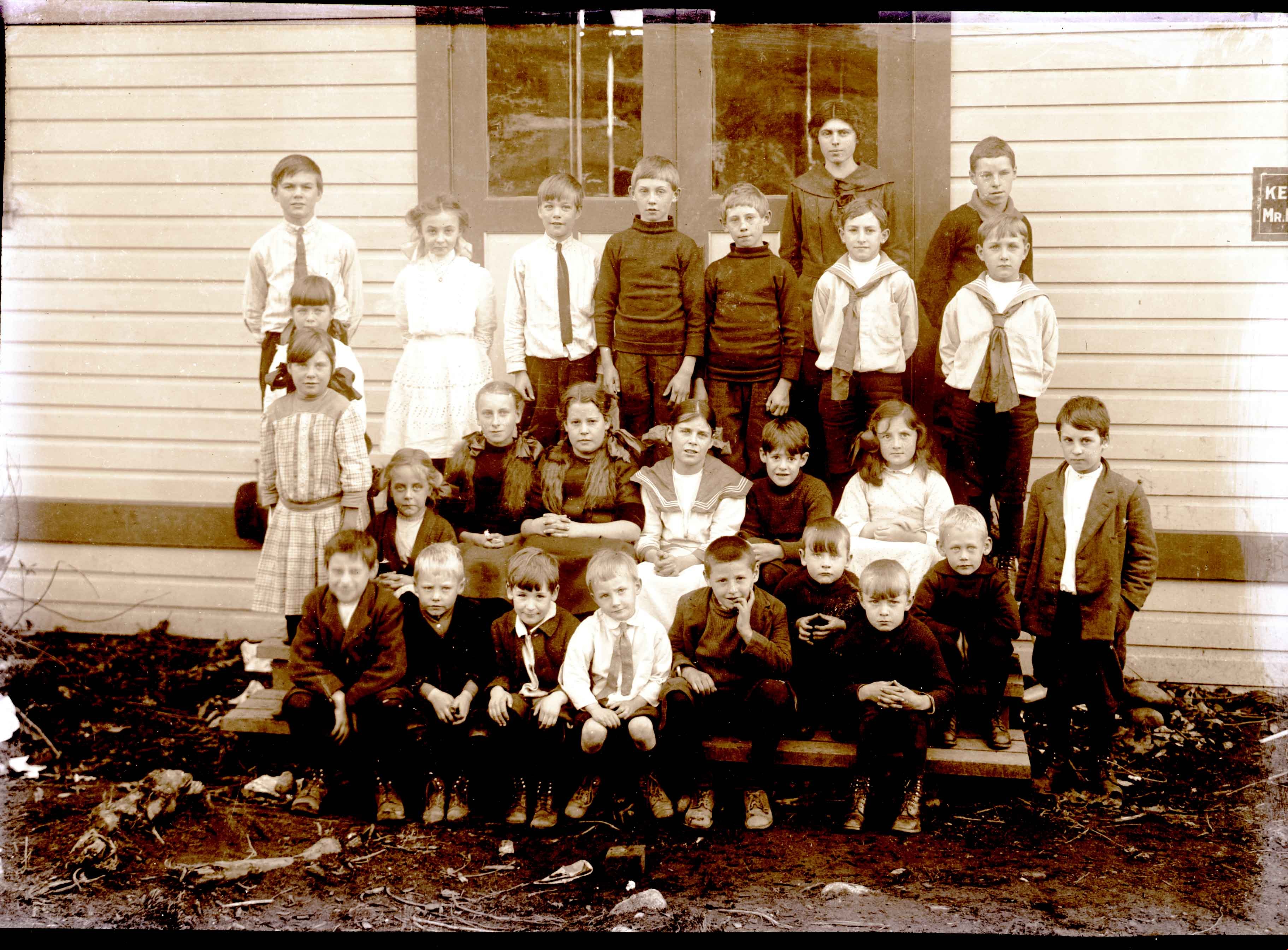
- Maude Goodridge Holmstrom (middle row, 4th from right) with her Howard Avenue class, photographed by J.W. Phillips, 1913. Item no. 487-004
- Length
- 0:07:09
- Historic Neighbourhood
- Capitol Hill (Historic Neighbourhood)
- Interviewer
- Johnson, Lou
- Interview Date
- April 1989
- Scope and Content
- Recording is of an interview with (Lucy) Maude (Goodridge) Holmstrom, conducted by her grandniece, Lou Johnson, April 1989. Major themes discussed are: Capitol Hill, early pioneers in Burnaby, Howard Avenue School.
- Biographical Notes
- Lucy Maude "Maude" Goodrige was born on Aprril 13, 1902 at Stanley Place, London, England. She was the eldest child of John Charles Bertram and Lucy (Elston) Goodridge, with four siblings; Alice Victoria, Gwendoline Elston "Gwen", Beatrice Alexandra, and George Edward Goodridge. John and Lucy Goodridge moved their family from Victoria Drive to Burnaby into a one room house on Capitol Hill, built over one year by John himself. At first, the family had to walk to Rosser to get drinking water, wheeling wheelbarrows full of water back home. Later on, John would discover a Grotto of fresh water on their property. When surveyors started showing land, travelling on horseback from Boundary Road to Capitol Hill, Lucy (Elston) Goodridge would offer lemonade and oranges to the thirsty settlers. This gave her the idea to start the first grocery store in the area, at Alpha and Hastings. Kelly Douglas helped the Goodridges stock the store with larger food orders. For smaller quantities, they used Swift and Company downtown. Maude first went to Howard Avenue School with her younger siblings then to the four room school Gilmore Avenue when it opened. Before John Goodridge went off to war in 1914, he handled grocery delivery and restocking using a team of horses. No one else in the family could handle the team, so while he was overseas, Maude would travel down to Swift and Company by streetcar and be forced to wait for a ride home from someone passing by as the stock was too heavy to carry on foot. Later, Maude remembers a Ford dealer coming to teach her how to drive, in effort to get her mother to buy a Ford. It worked. Maude lived at Capitol Hill until 1920. At the time of the depression, she was in California with her first husband, John Joseph Lemire whom she married October 14, 1922 in Vancouver. Gwendoline Elston "Gwen" Goodridge married William Lister of Point Grey, June 27, 1928. Alice Victoria Goodridge married David Augustus Norman September 24, 1929. Lucy Maude "Maude" (Goodridge) later married George William Holmstrom. George William Holmstrom died in 1957. His wife, Lucy Maude "Maude" (Goodridge) Holmstrom died in 1994.
- Total Tracks
- 3
- Total Length
- 0:23:44
- Interviewee Name
- Holmstrom, Lucy Maude "Maude" Goodridge Lemire
- Collection/Fonds
- Burnaby Historical Society fonds
- Subseries
- Oral history subseries
- Media Type
- Sound Recording
- Web Notes
- Interview was digitized in 2010 allowing it to be accessible on Heritage Burnaby. The digitization project was initiated by the Community Heritage Commission with support from City of Burnaby Council and the BC History Digitization Program of the Irving K. Barber Learning Centre, University of British Columbia. It was recognized by the Heritage Society of BC with an award in 2012.
Images
Audio Tracks
Track one of recording of interview with Maude Holmstrom
Track one of recording of interview with Maude Holmstrom
https://search.heritageburnaby.ca/media/hpo/_Data/_Archives_Oral_Histories/_Unrestricted/MSS137-007/MSS137-007_Track_1.mp3
Maude Holmstrom interview April 1989 - Track 3
https://search.heritageburnaby.ca/link/oralhistory265
- Repository
- City of Burnaby Archives
- Date Range
- 1909-1929
- Length
- 0:06:51
- Summary
- This portion of the recording includes (Lucy) Maude (Goodridge) Holmstrom's memories of her family life during the early days of Burnaby.
- Repository
- City of Burnaby Archives
- Summary
- This portion of the recording includes (Lucy) Maude (Goodridge) Holmstrom's memories of her family life during the early days of Burnaby.
- Date Range
- 1909-1929
- Photo Info
- Maude Goodridge Holmstrom (middle row, 4th from right) with her Howard Avenue class, photographed by J.W. Phillips, 1913. Item no. 487-004
- Length
- 0:06:51
- Historic Neighbourhood
- Capitol Hill (Historic Neighbourhood)
- Interviewer
- Johnson, Lou
- Interview Date
- April 1989
- Scope and Content
- Recording is of an interview with (Lucy) Maude (Goodridge) Holmstrom, conducted by her grandniece, Lou Johnson, April 1989. Major themes discussed are: Capitol Hill, early pioneers in Burnaby, Howard Avenue School.
- Biographical Notes
- Lucy Maude "Maude" Goodrige was born on Aprril 13, 1902 at Stanley Place, London, England. She was the eldest child of John Charles Bertram and Lucy (Elston) Goodridge, with four siblings; Alice Victoria, Gwendoline Elston "Gwen", Beatrice Alexandra, and George Edward Goodridge. John and Lucy Goodridge moved their family from Victoria Drive to Burnaby into a one room house on Capitol Hill, built over one year by John himself. At first, the family had to walk to Rosser to get drinking water, wheeling wheelbarrows full of water back home. Later on, John would discover a Grotto of fresh water on their property. When surveyors started showing land, travelling on horseback from Boundary Road to Capitol Hill, Lucy (Elston) Goodridge would offer lemonade and oranges to the thirsty settlers. This gave her the idea to start the first grocery store in the area, at Alpha and Hastings. Kelly Douglas helped the Goodridges stock the store with larger food orders. For smaller quantities, they used Swift and Company downtown. Maude first went to Howard Avenue School with her younger siblings then to the four room school Gilmore Avenue when it opened. Before John Goodridge went off to war in 1914, he handled grocery delivery and restocking using a team of horses. No one else in the family could handle the team, so while he was overseas, Maude would travel down to Swift and Company by streetcar and be forced to wait for a ride home from someone passing by as the stock was too heavy to carry on foot. Later, Maude remembers a Ford dealer coming to teach her how to drive, in effort to get her mother to buy a Ford. It worked. Maude lived at Capitol Hill until 1920. At the time of the depression, she was in California with her first husband, John Joseph Lemire whom she married October 14, 1922 in Vancouver. Gwendoline Elston "Gwen" Goodridge married William Lister of Point Grey, June 27, 1928. Alice Victoria Goodridge married David Augustus Norman September 24, 1929. Lucy Maude "Maude" (Goodridge) later married George William Holmstrom. George William Holmstrom died in 1957. His wife, Lucy Maude "Maude" (Goodridge) Holmstrom died in 1994.
- Total Tracks
- 3
- Total Length
- 0:23:44
- Interviewee Name
- Holmstrom, Lucy Maude "Maude" Goodridge Lemire
- Collection/Fonds
- Burnaby Historical Society fonds
- Subseries
- Oral history subseries
- Media Type
- Sound Recording
- Web Notes
- Interview was digitized in 2010 allowing it to be accessible on Heritage Burnaby. The digitization project was initiated by the Community Heritage Commission with support from City of Burnaby Council and the BC History Digitization Program of the Irving K. Barber Learning Centre, University of British Columbia. It was recognized by the Heritage Society of BC with an award in 2012.
Images
Audio Tracks
Track three of recording of interview with Maude Holmstrom
Track three of recording of interview with Maude Holmstrom
https://search.heritageburnaby.ca/media/hpo/_Data/_Archives_Oral_Histories/_Unrestricted/MSS137-007/MSS137-007_Track_3.mp3Tax Sale Properties- Quit Claim Deed to Land Belonging to Roman Catholic Bishop of New Westminster
https://search.heritageburnaby.ca/link/councilreport75276
- Repository
- City of Burnaby Archives
- Report ID
- 81667
- Meeting Date
- 20-Jun-1908
- Format
- Council - Mayor/Councillor/Staff Report
- Collection/Fonds
- City Council and Office of the City Clerk fonds
- Repository
- City of Burnaby Archives
- Report ID
- 81667
- Meeting Date
- 20-Jun-1908
- Format
- Council - Mayor/Councillor/Staff Report
- Collection/Fonds
- City Council and Office of the City Clerk fonds
Documents
Water on Land
https://search.heritageburnaby.ca/link/councilreport75667
- Repository
- City of Burnaby Archives
- Report ID
- 82021
- Meeting Date
- 15-Feb-1908
- Format
- Council - Mayor/Councillor/Staff Report
- Collection/Fonds
- City Council and Office of the City Clerk fonds
- Repository
- City of Burnaby Archives
- Report ID
- 82021
- Meeting Date
- 15-Feb-1908
- Format
- Council - Mayor/Councillor/Staff Report
- Collection/Fonds
- City Council and Office of the City Clerk fonds
Documents
Purchase of Additional Land for West Burnaby School
https://search.heritageburnaby.ca/link/councilreport74815
- Repository
- City of Burnaby Archives
- Report ID
- 81284
- Meeting Date
- 24-Jan-1908
- Format
- Council - Mayor/Councillor/Staff Report
- Collection/Fonds
- City Council and Office of the City Clerk fonds
- Repository
- City of Burnaby Archives
- Report ID
- 81284
- Meeting Date
- 24-Jan-1908
- Format
- Council - Mayor/Councillor/Staff Report
- Collection/Fonds
- City Council and Office of the City Clerk fonds
Documents
Deed of Land between George A. Stevens and George Leonard re District Lot 352 South Vancouver
https://search.heritageburnaby.ca/link/museumdescription18783
- Repository
- Burnaby Village Museum
- Date
- 28 Mar. 1908
- Collection/Fonds
- Love family fonds
- Description Level
- Item
- Physical Description
- 1 p. of textual records
- Scope and Content
- Item consists of Deed of Land between George A. Stevens and George Leonard for South Vancouver Lots eleven (11) and twelve (12) of the Subdivision of Lots nine (9), ten (10), eleven (11), twelve (12) and thirteen (13) of Block sixteen (16) in District Lot 352.
- Repository
- Burnaby Village Museum
- Collection/Fonds
- Love family fonds
- Description Level
- Item
- Physical Description
- 1 p. of textual records
- Scope and Content
- Item consists of Deed of Land between George A. Stevens and George Leonard for South Vancouver Lots eleven (11) and twelve (12) of the Subdivision of Lots nine (9), ten (10), eleven (11), twelve (12) and thirteen (13) of Block sixteen (16) in District Lot 352.
- Accession Code
- BV992.26.3
- Access Restriction
- No restrictions
- Reproduction Restriction
- No known restrictions
- Date
- 28 Mar. 1908
- Media Type
- Textual Record
- Notes
- Title based on contents of item
- buff paper, legal-sized, with black print; pink borders; folds out.
- Front of folded cover reads: "Dated March 28th 1908 / George A. Stevens / TO / George Leonard / DEED OF LAND / SITUATE I / South Vancouver / AND BEING / Lots Eleven (11) & Twelve (12) SubDiv (9)(10)(11)(12)&(13) Bk. (16) & Lot (352)" "115.5 x 33 / EVANS & HASTINGS PRINTERS"
- Inside reads: "This Indenture.../ between George A. Stevens of the City of Vancouver.../ And / George Leonard.../ ...sum of eight hundred and fifty ($850) .../ ... Lots Eleven (11) & Twelve (12) of the Subdivision of Lots nine (9) Ten (10) Eleven (11) Twelve (12) and Thirteen (13) / of Block Sixteen (16) in DistLot-Three Hundred & / fifty two (352) Group one (1) New Westminster District..."
- signed by George Stevens twice, small red seals; witnessed twice by William Carter; "FOR MAKER" signed by William Carter, April 4, 1908; stamp seal "WILLIAM CARTER" "BRITISH COLUMBIA" "NOTARY PUBLIC"

H.T. Ceperley Estate 'Fairacres' Greenhouse Foundation Wall
https://search.heritageburnaby.ca/link/landmark862
- Repository
- Burnaby Heritage Planning
- Description
- The original rubble stone walls that formed the foundation for a greenhouses adjacent to the Steam Plant Building provided heat to several greenhouses on the estate propoerty. The Root House, which is to the north of the Greenhouse Foundation Wall, provided storage for the farm operation.
- Associated Dates
- 1908
- Formal Recognition
- Heritage Designation, Community Heritage Register
- Repository
- Burnaby Heritage Planning
- Geographic Access
- Deer Lake Avenue
- Associated Dates
- 1908
- Formal Recognition
- Heritage Designation, Community Heritage Register
- Enactment Type
- Bylaw No. 140665
- Enactment Date
- 23/11/1992
- Description
- The original rubble stone walls that formed the foundation for a greenhouses adjacent to the Steam Plant Building provided heat to several greenhouses on the estate propoerty. The Root House, which is to the north of the Greenhouse Foundation Wall, provided storage for the farm operation.
- Heritage Value
- The outbuildings at 'Fairacres' are a rare surviving architecturally-designed ensemble of agricultural structures that exist in complementary harmony with the main estate house. Architect Robert Mackay Fripp (1858-1917), an outspoken advocate of Arts and Crafts design, was retained by the Ceperleys to design several original outbuildings on their estate, which was designed as a country estate with a working farm that included over 10 acres of productive berry and vegetable fields, with a large kitchen garden, a root house to store food, an orchard, and greenhouses heated by steam. The agricultural potential of the Deer Lake area made it one of the first parts of the municipality to attract settlement. In 1909, the Ceperleys built three large greenhouses heated by an adjacent steam plant (Fairacres Steam Plant). The greenhouses featured granite foundation walls, including this one which remains intact. The Ceperleys employed a large staff to manage the estate's agricultural production, including Chinese farm labourers. Produce was grown for use at the estate, and for sale at local markets. Agricultural use of the estate continued when a Catholic order of Benedictine monks purchased the estate as part of the Priory of St. Joseph and the Seminary of Christ the King, and continued to farm the land until 1953.
- Defining Elements
- Key elements that define the heritage character of the ‘Fairacres’ Steam Plant Building include its: - overall spatial arrangement of the Greenhouse Foundation Wall in relation to the Steam Plant Building and the Root House - original rubble stone walls reflecting the Arts and Crafts design aesthetic of the estate buildings.
- Locality
- Deer Lake Park
- Historic Neighbourhood
- Burnaby Lake (Historic Neighbourhood)
- Planning Study Area
- Douglas-Gilpin Area
- Architect
- Robert Mackay Fripp
- Function
- Primary Historic--Outbuilding
- Community
- Burnaby
- Cadastral Identifier
- P.I.D. No. 004-493-311 Legal Description: Block 3 Except: Part subdivided by Plan 26865, District Lot 79, Group 1, New Westminster District, Plan 536
- Boundaries
- ‘Fairacres’ is comprised of a single municipally-owned property located at 6344 Deer Lake Avenue, Burnaby.
- Area
- 17,065.00
- Contributing Resource
- Landscape Feature
- Remains
- Ownership
- Public (local)
- Other Collection
- Burnaby Historical Society, Community Archives: Ceperley Photograph Album
- Documentation
- Heritage Site Files: PC77000 20. City of Burnaby Planning and Building Department, 4949 Canada Way, Burnaby, B.C., V5G 1M2
- Street Address
- 6344 Deer Lake Avenue
Images


![Looking down north Poleline Hill, [1908] thumbnail](/media/hpo/_Data/_BVM_Images/1976/1976_0139_0047_001.jpg?width=280)
Looking down north Poleline Hill
https://search.heritageburnaby.ca/link/museumdescription796
- Repository
- Burnaby Village Museum
- Date
- [1908]
- Collection/Fonds
- Burnaby Village Museum Photograph collection
- Description Level
- Item
- Physical Description
- 1 photograph : b&w ; 20.32 x 25.4 cm print
- Scope and Content
- Photograph looking north along the Pole Line Road (later Sperling Avenue). To the far left is Deer Lake and at the top right is Burnaby Lake. The smoke and debris from land clearing is a result of logging operations being carried out by the Doran Brothers logging company, the Deer Lake Mill Company…
- Repository
- Burnaby Village Museum
- Collection/Fonds
- Burnaby Village Museum Photograph collection
- Description Level
- Item
- Physical Description
- 1 photograph : b&w ; 20.32 x 25.4 cm print
- Material Details
- inscribed in pencil, verso, l.l. "Looking down north Poleline Hill (now Sperling) Deer Lake at left. "
- Scope and Content
- Photograph looking north along the Pole Line Road (later Sperling Avenue). To the far left is Deer Lake and at the top right is Burnaby Lake. The smoke and debris from land clearing is a result of logging operations being carried out by the Doran Brothers logging company, the Deer Lake Mill Company. Above Deer Lake, Douglas Road is visible with Claude Hill's Brookfield property (later 6501 Deer Lake Avenue) on the south side of the road and Bernard Hill's home on the north side (later 4990 Canada Way). Just northeast of Brookfield is the George Every-Clayton farm (amongst the trees) on what would later become the Henry and Grace Ceperley estate grounds known as Fairacres. The house in the centre of the picture is the Walker house (later 5255 Sperling Avenue). Mountains can be seen to the north.
- Subjects
- Land Clearing
- Geographic Features - Roads
- Industries - Forestry
- Industries - Logging/lumber
- Geographic Access
- Sperling Avenue
- Deer Lake
- Douglas Road
- Canada Way
- Accession Code
- HV976.139.47
- Access Restriction
- No restrictions
- Reproduction Restriction
- No known restrictions
- Date
- [1908]
- Media Type
- Photograph
- Historic Neighbourhood
- Burnaby Lake (Historic Neighbourhood)
- Planning Study Area
- Morley-Buckingham Area
- Scan Resolution
- 600
- Scan Date
- 2023-06-27
- Notes
- Title based on contents of photograph
Images
![Looking down north Poleline Hill, [1908] thumbnail](/media/hpo/_Data/_BVM_Images/1976/1976_0139_0047_001.jpg)

Linden Avenue
https://search.heritageburnaby.ca/link/archivedescription35000
- Repository
- City of Burnaby Archives
- Date
- 1908 (date of original), copied 1986
- Collection/Fonds
- Burnaby Historical Society fonds
- Description Level
- Item
- Physical Description
- 1 photograph : b&w ; 8.8 x 12.5 cm print
- Scope and Content
- Photograph of trees and stumps on Linden Avenue, Edmonds District. The caption at the bottom right of the photograph reads, "Linden Ave. / Edmonds 1908."
- Repository
- City of Burnaby Archives
- Date
- 1908 (date of original), copied 1986
- Collection/Fonds
- Burnaby Historical Society fonds
- Subseries
- Patterson family subseries
- Physical Description
- 1 photograph : b&w ; 8.8 x 12.5 cm print
- Description Level
- Item
- Record No.
- 171-021
- Access Restriction
- No restrictions
- Reproduction Restriction
- No known restrictions
- Accession Number
- BHS1986-20
- Scope and Content
- Photograph of trees and stumps on Linden Avenue, Edmonds District. The caption at the bottom right of the photograph reads, "Linden Ave. / Edmonds 1908."
- Media Type
- Photograph
- Geographic Access
- Linden Avenue
- Historic Neighbourhood
- Edmonds (Historic Neighbourhood)
- Planning Study Area
- Richmond Park Area
Images

![O.G. Naud house, [1908] (date of original), copied 1986 thumbnail](/media/hpo/_Data/_Archives_Images/_Unrestricted/126/172-002-001.jpg?width=280)
O.G. Naud house
https://search.heritageburnaby.ca/link/archivedescription35005
- Repository
- City of Burnaby Archives
- Date
- [1908] (date of original), copied 1986
- Collection/Fonds
- Burnaby Historical Society fonds
- Description Level
- Item
- Physical Description
- 1 photograph : b&w ; 8.8 x 12.5 cm print
- Scope and Content
- Photograph is the left side of a three-part panorama (photos 172-002a to 172-002c) of the land beside the house of Onezime G. Naud, 4737 Victory Road (later renamed Victory Street). A garden and a fence with a woman standing beside it can be seen.
- Repository
- City of Burnaby Archives
- Date
- [1908] (date of original), copied 1986
- Collection/Fonds
- Burnaby Historical Society fonds
- Subseries
- O.G. Naud subseries
- Physical Description
- 1 photograph : b&w ; 8.8 x 12.5 cm print
- Description Level
- Item
- Record No.
- 172-002-1
- Access Restriction
- No restrictions
- Reproduction Restriction
- No known restrictions
- Accession Number
- BHS1986-21
- Scope and Content
- Photograph is the left side of a three-part panorama (photos 172-002a to 172-002c) of the land beside the house of Onezime G. Naud, 4737 Victory Road (later renamed Victory Street). A garden and a fence with a woman standing beside it can be seen.
- Subjects
- Buildings - Residential - Houses
- Media Type
- Photograph
- Notes
- Title based on contents of photograph
- b&w ; 5.5 x 24.5 cm photocopy of entire panorama accompanying in accession file
- Geographic Access
- Victory Street
- Street Address
- 4737 Victory Street
- Historic Neighbourhood
- Alta-Vista (Historic Neighbourhood)
- Planning Study Area
- Sussex-Nelson Area
Images
![O.G. Naud house, [1908] (date of original), copied 1986 thumbnail](/media/hpo/_Data/_Archives_Images/_Unrestricted/126/172-002-001.jpg)
![O.G. Naud house, [1908] (date of original), copied 1986 thumbnail](/media/hpo/_Data/_Archives_Images/_Unrestricted/126/172-002-003.jpg?width=280)
O.G. Naud house
https://search.heritageburnaby.ca/link/archivedescription39832
- Repository
- City of Burnaby Archives
- Date
- [1908] (date of original), copied 1986
- Collection/Fonds
- Burnaby Historical Society fonds
- Description Level
- Item
- Physical Description
- 1 photograph : b&w ; 8.8 x 12.5 cm print
- Scope and Content
- Photograph is the right side of a three-part panorama (photos 172-002a to 172-002c) showing the land beside the house of Onezime G. Naud at 4737 Victory Road (later renamed Victory Street). A number of adults and children are seen standing in a field.
- Repository
- City of Burnaby Archives
- Date
- [1908] (date of original), copied 1986
- Collection/Fonds
- Burnaby Historical Society fonds
- Subseries
- O.G. Naud subseries
- Physical Description
- 1 photograph : b&w ; 8.8 x 12.5 cm print
- Description Level
- Item
- Record No.
- 172-002-3
- Access Restriction
- No restrictions
- Reproduction Restriction
- No known restrictions
- Accession Number
- BHS1986-21
- Scope and Content
- Photograph is the right side of a three-part panorama (photos 172-002a to 172-002c) showing the land beside the house of Onezime G. Naud at 4737 Victory Road (later renamed Victory Street). A number of adults and children are seen standing in a field.
- Media Type
- Photograph
- Notes
- Title based on contents of photograph
- b&w ; 5.5 x 24.5 cm photocopy of entire panorama accompanying in accession file
- Geographic Access
- Victory Street
- Street Address
- 4737 Victory Street
- Historic Neighbourhood
- Alta-Vista (Historic Neighbourhood)
- Planning Study Area
- Sussex-Nelson Area
Images
![O.G. Naud house, [1908] (date of original), copied 1986 thumbnail](/media/hpo/_Data/_Archives_Images/_Unrestricted/126/172-002-003.jpg)
Mortgage (Taylor, Alfred E.)
https://search.heritageburnaby.ca/link/archivedescription332
- Repository
- City of Burnaby Archives
- Date
- 1908-1919
- Collection/Fonds
- City Council and Office of the City Clerk fonds
- Description Level
- File
- Physical Description
- Textual record
- Scope and Content
- File contains land registry, correspondence, and other notes related to a mortgage held by Alfred E. Taylor for the land on block 24, DL 35.
- Repository
- City of Burnaby Archives
- Date
- 1908-1919
- Collection/Fonds
- City Council and Office of the City Clerk fonds
- Physical Description
- Textual record
- Description Level
- File
- Record No.
- 2025
- Accession Number
- 2001-02
- Scope and Content
- File contains land registry, correspondence, and other notes related to a mortgage held by Alfred E. Taylor for the land on block 24, DL 35.
- Media Type
- Textual Record