Narrow Results By
Subject
- Advertising Medium - Signs and Signboards 2
- Animals - Dogs 1
- Animals - Poultry 1
- Buildings - Commercial 3
- Buildings - Commercial - Automobile Dealerships 1
- Buildings - Industrial 1
- Construction 1
- Construction Tools and Equipment 1
- Geographic Features - Forests 1
- Geographic Features - Lakes and Ponds 1
- Geographic Features - Parks 1
- Geographic Features - Roads 1

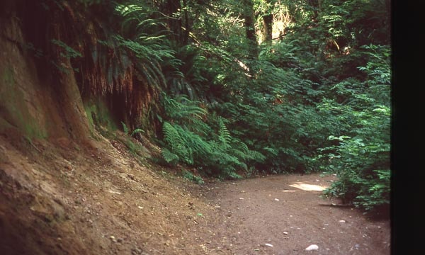
Cut of land on Burnaby Mountain
https://search.heritageburnaby.ca/link/archivedescription97810
- Repository
- City of Burnaby Archives
- Date
- 1996
- Collection/Fonds
- Burnaby Mountain Preservation Society fonds
- Description Level
- Item
- Physical Description
- 1 photograph : col. slide ; 35 mm
- Scope and Content
- Photograph of a cut of land.
- Repository
- City of Burnaby Archives
- Date
- 1996
- Collection/Fonds
- Burnaby Mountain Preservation Society fonds
- Physical Description
- 1 photograph : col. slide ; 35 mm
- Description Level
- Item
- Record No.
- 629-011
- Access Restriction
- No restrictions
- Reproduction Restriction
- Reproduce for fair dealing purposes only
- Accession Number
- 2006-13
- Scope and Content
- Photograph of a cut of land.
- Subjects
- Geographic Features - Trails
- Media Type
- Photograph
- Notes
- Stamp on slide reads: "July 08, 1996."
- Geographic Access
- Burnaby Mountain Conservation Area
- Planning Study Area
- Burnaby Mountain Area
Images
![Land surveyor on a road, [1999] thumbnail](/media/hpo/_Data/_Archives_Images/_Unrestricted/535/535-3313.jpg?width=280)
Land surveyor on a road
https://search.heritageburnaby.ca/link/archivedescription98246
- Repository
- City of Burnaby Archives
- Date
- [1999]
- Collection/Fonds
- Burnaby NewsLeader photograph collection
- Description Level
- Item
- Physical Description
- 1 photograph (tiff) : b&w
- Scope and Content
- Photograph of an unidentified land surveyor standing behind a land surveying total station at the curve of a road.
- Repository
- City of Burnaby Archives
- Date
- [1999]
- Collection/Fonds
- Burnaby NewsLeader photograph collection
- Physical Description
- 1 photograph (tiff) : b&w
- Description Level
- Item
- Record No.
- 535-3313
- Access Restriction
- No restrictions
- Reproduction Restriction
- No restrictions
- Accession Number
- 2018-12
- Scope and Content
- Photograph of an unidentified land surveyor standing behind a land surveying total station at the curve of a road.
- Media Type
- Photograph
- Notes
- Title based on contents of photograph
- Collected by editorial for use in a September 1999 issue of the Burnaby NewsLeader
Images
![Land surveyor on a road, [1999] thumbnail](/media/hpo/_Data/_Archives_Images/_Unrestricted/535/535-3313.jpg)
1160 Douglas Rd
https://search.heritageburnaby.ca/link/archivedescription94327
- Repository
- City of Burnaby Archives
- Date
- December 1994
- Collection/Fonds
- Grover, Elliott & Co. Ltd. fonds
- Description Level
- File
- Physical Description
- 22 photographs : col. negatives ; 35 mm
- Scope and Content
- Photographs of the exterior of a three-storey commerical building located at 1160 Douglas Road.
- Repository
- City of Burnaby Archives
- Date
- December 1994
- Collection/Fonds
- Grover, Elliott & Co. Ltd. fonds
- Physical Description
- 22 photographs : col. negatives ; 35 mm
- Description Level
- File
- Record No.
- 622-112
- Access Restriction
- No restrictions
- Reproduction Restriction
- No restrictions
- Accession Number
- 2017-39
- Scope and Content
- Photographs of the exterior of a three-storey commerical building located at 1160 Douglas Road.
- Media Type
- Photograph
- Photographer
- Young, Richard
- Notes
- Transcribed title
- Title transcribed from envelope photographs were originally housed in
- File no. 94-424-B
- Geographic Access
- Douglas Road
- Street Address
- 1160 Douglas Road
- Historic Neighbourhood
- Vancouver Heights (Historic Neighbourhood)
- Planning Study Area
- Willingdon Heights Area
4010 Regent St.
https://search.heritageburnaby.ca/link/archivedescription94318
- Repository
- City of Burnaby Archives
- Date
- September 1994
- Collection/Fonds
- Grover, Elliott & Co. Ltd. fonds
- Description Level
- File
- Physical Description
- 25 photographs : col. negatives ; 35 mm
- Scope and Content
- Photographs of an undeveloped property located at 4010 Regent Street. Property is covered with soil, brush, and some trees.
- Repository
- City of Burnaby Archives
- Date
- September 1994
- Collection/Fonds
- Grover, Elliott & Co. Ltd. fonds
- Physical Description
- 25 photographs : col. negatives ; 35 mm
- Description Level
- File
- Record No.
- 622-103
- Access Restriction
- No restrictions
- Reproduction Restriction
- No restrictions
- Accession Number
- 2017-39
- Scope and Content
- Photographs of an undeveloped property located at 4010 Regent Street. Property is covered with soil, brush, and some trees.
- Subjects
- Land Clearing
- Media Type
- Photograph
- Photographer
- Young, Richard
- Notes
- Transcribed title
- Title transcribed from envelope photographs were originally housed in
- File no. 94-342-B
- Geographic Access
- Regent Street
- Street Address
- 4010 Regent Street
- Historic Neighbourhood
- Broadview (Historic Neighbourhood)
- Planning Study Area
- West Central Valley Area
5200 Oakmount Cr.
https://search.heritageburnaby.ca/link/archivedescription94313
- Repository
- City of Burnaby Archives
- Date
- June 1994
- Collection/Fonds
- Grover, Elliott & Co. Ltd. fonds
- Description Level
- File
- Physical Description
- 23 photographs : col. negatives ; 35 mm
- Scope and Content
- Photographs of an undeveloped property located at 5200 Oakmount Crescent - an address that no longer exists.
- Repository
- City of Burnaby Archives
- Date
- June 1994
- Collection/Fonds
- Grover, Elliott & Co. Ltd. fonds
- Physical Description
- 23 photographs : col. negatives ; 35 mm
- Description Level
- File
- Record No.
- 622-098
- Access Restriction
- No restrictions
- Reproduction Restriction
- No restrictions
- Accession Number
- 2017-39
- Scope and Content
- Photographs of an undeveloped property located at 5200 Oakmount Crescent - an address that no longer exists.
- Subjects
- Land Clearing
- Media Type
- Photograph
- Notes
- Transcribed title
- Title transcribed from envelope photographs were originally housed in
- File no. 94-236-B
- Photographer identified as "J.C."
- Geographic Access
- Oakmount Crescent
- Historic Neighbourhood
- Central Park (Historic Neighbourhood)
- Planning Study Area
- Windsor Area
5548 Marshland Ave
https://search.heritageburnaby.ca/link/archivedescription94302
- Repository
- City of Burnaby Archives
- Date
- January 1994
- Collection/Fonds
- Grover, Elliott & Co. Ltd. fonds
- Description Level
- File
- Physical Description
- 25 photographs : col. negatives ; 35 mm
- Scope and Content
- Photographs of an undeveloped property located at 5548 Marshland Avenue - an address that no longer exists.
- Repository
- City of Burnaby Archives
- Date
- January 1994
- Collection/Fonds
- Grover, Elliott & Co. Ltd. fonds
- Physical Description
- 25 photographs : col. negatives ; 35 mm
- Description Level
- File
- Record No.
- 622-087
- Access Restriction
- No restrictions
- Reproduction Restriction
- No restrictions
- Accession Number
- 2017-39
- Scope and Content
- Photographs of an undeveloped property located at 5548 Marshland Avenue - an address that no longer exists.
- Subjects
- Land Clearing
- Media Type
- Photograph
- Notes
- Transcribed title
- Title transcribed from envelope photographs were originally housed in
- File no. 94-023-B
- Photographer identified as "K.D."
- Geographic Access
- Marshland Avenue
- Historic Neighbourhood
- Fraser Arm (Historic Neighbourhood)
- Planning Study Area
- Big Bend Area
7026 Kingsway
https://search.heritageburnaby.ca/link/archivedescription94304
- Repository
- City of Burnaby Archives
- Date
- January 1994
- Collection/Fonds
- Grover, Elliott & Co. Ltd. fonds
- Description Level
- File
- Physical Description
- 19 photographs : col. negatives ; 35 mm
- Scope and Content
- Photographs of commercial and undeveloped properties located in the 7100 block of Kingsway, including Middlegate Honda, with mid-rise towers visible in the background.
- Repository
- City of Burnaby Archives
- Date
- January 1994
- Collection/Fonds
- Grover, Elliott & Co. Ltd. fonds
- Physical Description
- 19 photographs : col. negatives ; 35 mm
- Description Level
- File
- Record No.
- 622-089
- Access Restriction
- No restrictions
- Reproduction Restriction
- No restrictions
- Accession Number
- 2017-39
- Scope and Content
- Photographs of commercial and undeveloped properties located in the 7100 block of Kingsway, including Middlegate Honda, with mid-rise towers visible in the background.
- Media Type
- Photograph
- Notes
- Transcribed title
- Title transcribed from envelope photographs were originally housed in
- File no. 94-028-B
- Photographer identified as "L.D."
- Geographic Access
- Kingsway
- Historic Neighbourhood
- Edmonds (Historic Neighbourhood)
- Planning Study Area
- Stride Avenue Area
8980 Fraserwood Crt
https://search.heritageburnaby.ca/link/archivedescription94326
- Repository
- City of Burnaby Archives
- Date
- December 1994
- Collection/Fonds
- Grover, Elliott & Co. Ltd. fonds
- Description Level
- File
- Physical Description
- 24 photographs : col. negatives ; 35 mm
- Scope and Content
- Photographs of an undeveloped property located at 8980 Fraserwood Court. A Sutton Group real estate sign on the property advertises the site as the Fraserwood Corporate Centre with strata warehouse and office flex space. File also contains photographs of the commerical building adjacent to the si…
- Repository
- City of Burnaby Archives
- Date
- December 1994
- Collection/Fonds
- Grover, Elliott & Co. Ltd. fonds
- Physical Description
- 24 photographs : col. negatives ; 35 mm
- Description Level
- File
- Record No.
- 622-111
- Access Restriction
- No restrictions
- Reproduction Restriction
- No restrictions
- Accession Number
- 2017-39
- Scope and Content
- Photographs of an undeveloped property located at 8980 Fraserwood Court. A Sutton Group real estate sign on the property advertises the site as the Fraserwood Corporate Centre with strata warehouse and office flex space. File also contains photographs of the commerical building adjacent to the site.
- Media Type
- Photograph
- Notes
- Transcribed title
- Title transcribed from envelope photographs were originally housed in
- File no. 94-422-B
- Photographer identified as "L.D."
- Geographic Access
- Fraserwood Court
- Street Address
- 8980 Fraserwood Court
- Historic Neighbourhood
- Fraser Arm (Historic Neighbourhood)
- Planning Study Area
- Big Bend Area
Burnaby
https://search.heritageburnaby.ca/link/archivedescription93751
- Repository
- City of Burnaby Archives
- Date
- 1991
- Collection/Fonds
- Grover, Elliott & Co. Ltd. fonds
- Description Level
- File
- Physical Description
- 43 photographs : col. negatives ; 35 mm
- Scope and Content
- Photographs of the exterior of a single-storey industrial building and surrounding undeveloped property. A sign on the building reads "Bauer". The location of the building has not been identified.
- Repository
- City of Burnaby Archives
- Date
- 1991
- Collection/Fonds
- Grover, Elliott & Co. Ltd. fonds
- Physical Description
- 43 photographs : col. negatives ; 35 mm
- Description Level
- File
- Record No.
- 622-036
- Access Restriction
- No restrictions
- Reproduction Restriction
- No restrictions
- Accession Number
- 2017-39
- Scope and Content
- Photographs of the exterior of a single-storey industrial building and surrounding undeveloped property. A sign on the building reads "Bauer". The location of the building has not been identified.
- Subjects
- Buildings - Industrial
- Land Clearing
- Media Type
- Photograph
- Notes
- Transcribed title
- Title transcribed from envelope photographs were originally housed in
- File no. 91-452-B

Residents involved in protesting tree removal
https://search.heritageburnaby.ca/link/archivedescription78595
- Repository
- City of Burnaby Archives
- Date
- October 8, 1995
- Collection/Fonds
- Burnaby NewsLeader photograph collection
- Description Level
- Item
- Physical Description
- 1 photograph : b&w ; 16.5 x 24.5 cm
- Scope and Content
- Photograph of residents of Burnaby protesting the clearing of land around the Hong Kong Bank, in Discovery Park industrial site near British Columbia Institute of Technology (BCIT).
- Repository
- City of Burnaby Archives
- Date
- October 8, 1995
- Collection/Fonds
- Burnaby NewsLeader photograph collection
- Physical Description
- 1 photograph : b&w ; 16.5 x 24.5 cm
- Description Level
- Item
- Record No.
- 535-0011
- Access Restriction
- No restrictions
- Reproduction Restriction
- No reproduction permitted
- Accession Number
- 2012-11
- Scope and Content
- Photograph of residents of Burnaby protesting the clearing of land around the Hong Kong Bank, in Discovery Park industrial site near British Columbia Institute of Technology (BCIT).
- Names
- Chami, Parvin
- Media Type
- Photograph
- Photographer
- Ponne, Simone
- Notes
- Title based on contents of photograph
- Note in black ink on recto of photograph reads: "2764A Bby Ponne / Bby p. 1 81%"
- Trim marks and/or reproduction instructions on recto (scan is cropped)
- Geographic Access
- Willingdon Avenue
- Planning Study Area
- Douglas-Gilpin Area
Images

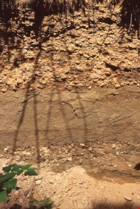
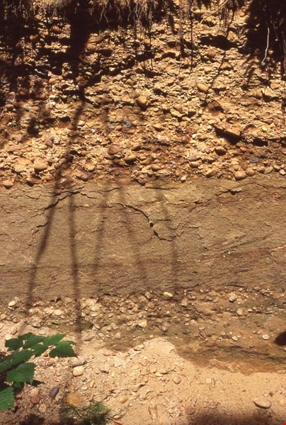
Sediment layers on Burnaby Mountain
https://search.heritageburnaby.ca/link/archivedescription97811
- Repository
- City of Burnaby Archives
- Date
- 1996
- Collection/Fonds
- Burnaby Mountain Preservation Society fonds
- Description Level
- Item
- Physical Description
- 1 photograph : col. slide ; 35 mm
- Scope and Content
- Photograph of sediment layers.
- Repository
- City of Burnaby Archives
- Date
- 1996
- Collection/Fonds
- Burnaby Mountain Preservation Society fonds
- Physical Description
- 1 photograph : col. slide ; 35 mm
- Description Level
- Item
- Record No.
- 629-012
- Access Restriction
- No restrictions
- Reproduction Restriction
- Reproduce for fair dealing purposes only
- Accession Number
- 2006-13
- Scope and Content
- Photograph of sediment layers.
- Subjects
- Land
- Media Type
- Photograph
- Notes
- Stamp on slide reads: "July 08, 1996."
- Geographic Access
- Burnaby Mountain Conservation Area
- Planning Study Area
- Burnaby Mountain Area
Images
William Holmes fonds
https://search.heritageburnaby.ca/link/museumdescription10416
- Repository
- Burnaby Village Museum
- Date
- [1841]-1994
- Collection/Fonds
- William Holmes fonds
- Description Level
- Fonds
- Physical Description
- 2 photographs (calotype) + 1 photograph : b&w + 6 photographs : col. + 5 p. textual records + 1 newspaper clipping
- Scope and Content
- Fonds consists of photographs pertaining to the William Holmes family, family grave markers in cemetery in Ireland along with original correspondence, land title certificates and a newspaper clipping. Fonds is arranged in series: 1) William Holmes family photographs series 2) William Holmes family…
- Repository
- Burnaby Village Museum
- Collection/Fonds
- William Holmes fonds
- Description Level
- Fonds
- Physical Description
- 2 photographs (calotype) + 1 photograph : b&w + 6 photographs : col. + 5 p. textual records + 1 newspaper clipping
- Scope and Content
- Fonds consists of photographs pertaining to the William Holmes family, family grave markers in cemetery in Ireland along with original correspondence, land title certificates and a newspaper clipping. Fonds is arranged in series: 1) William Holmes family photographs series 2) William Holmes family records series 3) Holmes family cemetery photographs series
- History
- William Holmes was the first non-Indigenous resident of Burnaby and was born in Kilkenny Ireland January 4, 1812. In 1833, at the age of 20 yrs, William Holmes immigrated to Canada from Ireland in with his parents, Joseph and Jane (McCullough) Holmes and ten other family members including two of his married brothers and their wives, two sisters with their husbands and two unmarried brothers. This was the first group of thirteen to leave Ireland and set up homesteads in Canada near the shores of Lake Huron. The family settled on land concessions in Huron County, Ontario about 14 km southeast of Goderich. The area in Huron County was first founded in 1832 by John and Samuel Holmes and the community was known as Holmes Hill before becoming Holmesville [ca. 1850]. In 1837, William Holmes is noted as owning Lot 23, Concession IX, Goderich Twp. Much of the village of Holmesville grew up around the five road concession near the border of his brother’s farm so William decided to open a store. The Holmesville post office opened on March 1, 1855 and William was appointed the first post master which he operated until May 1857. William met and married Mary Richardson in 1841 and the couple had three daughters: Jane (1844-1926) (married Charles Studdert Finlaison in New Westminster in 1863); Anne Maria (Annie) (1846-192?) (married John Gunther Jennings in New Westminster in 1865 and married Robert Johnson in New Westminster in 1877) and Elizabeth (1848-1934) (married Thomas Carrington of Lakes District in 1867). William’s wife, Mary (Richardson) Holmes died in Holmesville sometime between 1848 and 1853. Following the death of his first wife, Mary, William married Charlotte McCullough (McCulloch). The couple had four daughters; Arabella Charlotte Amelia (1854-1943) (married Arthur Robert Green in 1887); Laura (1855-1867); Arabella Henrietta (1857-1929) (married Clark Wesley Gillanders in 1880) and Mary (1863-1864). During the late 1850s, William became aware of the gold rush and opportunities opening up in British Columbia so left for the west coast in 1858 at the age of 46 yrs. In preparation for his move to the west coast of Canada, William obtained a letter of introduction from top government officials of Canada. William Holmes arrived in British Columbia in 1859. Upon arriving, he first worked running pack trains from Harrison Mills to Lillooet. After earning some money, he decided to re-invest it in land. His first pre-emption of land occurred on January 21, 1860 for 160 acres situated on North Road from the Military Camp to Burrard Inlet and distancing 25 chains south of the Brunette River and 20 chains south of the river with the land extending in a westerly direction. On March 17, 1860, Holmes received a Crown Grant for this and other land in the immediate area totalling 415 acres of which was known as Lot No. 1, Group 1, Rural Land, New Westminster District. The balance of land was situated on the east side of the Brunette River – Lot 13, with 344 2/3 acres of which he made an application to purchase on June 26, 1860, and a Crown Grant dated March 16, 1861 covering 86 acres. Holmes also pre-empted land in Port Moody and Pitt Meadows in 1860 and 1861. The name of “Brunette River” is officially attributed to William Holmes who referred to the river as “Brunette” due to it’s dark colour originating from the peat lands above the lake. Following his purchase of property, he sent for his wife Charlotte, their three daughters and her three step daughters (from William’s first marriage). Charlotte and the six children made the long trip to B.C. by ship and rail, crossing the Isthmus of Darien at Panama. They arrived in B.C. in October 1861 and moved into a one room log cabin built by William. The cabin stood on the North Road at the foot of Sapperton, on a bluff overlooking the Brunette River. Eventually the family moved to a larger dwelling but the original cabin remained on the site until the 1890s when it was burned after being used as a sick house. Mr. Holmes was instrumental in organizing the first Orange Lodge in British Columbia. He was a prominent Orangeman who joined the order in 1840 and was the first master in the order of the City of New Westminster when the Lodge No. 1150 was established there. Charlotte Holmes died in New Westminster in 1893 at the age of 70 years and William Holmes died in New Westminster September 11, 1907 at the age of 95 years.
- Responsibility
- Holmes, William
- Accession Code
- HV971.46
- BV997.50
- Date
- [1841]-1994
- Media Type
- Photograph
- Textual Record
- Related Material
- See also: Reference file: Persons - Holmes, William
- Notes
- Title based on contents of fonds
Jesse Love farmhouse series
https://search.heritageburnaby.ca/link/museumdescription9782
- Repository
- Burnaby Village Museum
- Date
- [1893-1970] (date of originals), copied 1988-1998, predominant 1988-2000
- Collection/Fonds
- Burnaby Village Museum fonds
- Description Level
- Series
- Physical Description
- approx. 84 cm of textual records + approx. 1,910 photographs + approx. 100 architectural drawings + 3 audio cassettes + 1 videocassette
- Scope and Content
- Series consists of records involved in the purchase, moving, restoration, research, conservation and exhibiting of the Love family farmhouse by Burnaby Village Museum. Records have been arranged into the following subseries: 1) Love farmhouse conservation work files subseries 2) Love farmhouse re…
- Repository
- Burnaby Village Museum
- Collection/Fonds
- Burnaby Village Museum fonds
- Series
- Jesse Love farmhouse series
- Description Level
- Series
- Physical Description
- approx. 84 cm of textual records + approx. 1,910 photographs + approx. 100 architectural drawings + 3 audio cassettes + 1 videocassette
- Scope and Content
- Series consists of records involved in the purchase, moving, restoration, research, conservation and exhibiting of the Love family farmhouse by Burnaby Village Museum. Records have been arranged into the following subseries: 1) Love farmhouse conservation work files subseries 2) Love farmhouse restoration photographs subseries 3) Love farmhouse curatorial files subseries 4) Love farmouse research files subseries 5) Love family photographs 6) Love farmhouse Oral History subseries 7) Love farmhouse architectural drawings subseries
- History
- Jesse Love was born in Swindon, England in 1847 and left England to work on a dairy farm in the Toronto area. While working on the farm in Toronto, he met Martha Leonard who he married in 1879. Martha was born on February 3, 1858 in Bedfordshire, England and had come to Canada with her parents George and Ann Leonard. While living in Toronto, Jesse and Martha had two children, George born March 22, 1880 and Annie Elizabeth on August 24, 1881. About one year after Annie was born, the Love family moved to North Dakota to grow wheat. While living there, they had two more children, Henry who was born August 24, 1883 and Edith Minnie born October 9, 1885. The family decided to move further west after hearing about the fairer weather conditions from Martha’s father, George Leonard, who had settled in Vancouver in 1885. On May 23, 1887, Jesse, Martha and their four children arrived in Vancouver after travelling across Canada from Winnipeg on the first transcontinental train. The Loves made their home in Vancouver while Jesse helped clear land on Granville Street. Their fifth child, Thomas Robert was born on September 17, 1887 and soon after, the family moved to Lulu Island in Richmond where they lived growing vegetables and selling them to Vancouver hotels. While living and farming on Lulu island, the couple had two more girls, Martha (Dot or Dorothy) born on December 17, 1889 and Sarah Marie, born February 8, 1892. On October 6, 1893 an agreement was signed by Jesse Love to purchase 14.52 acres of land from Joseph C. Armstrong. The acreage covered the north east section of District Lot 25 within the newly incorporated District of the Municipality of Burnaby. It was here where the original Love house was built (between October 1893 and April 15, 1894) by Jesse Love with the help of local builder George Salt and father in law, George Leonard. The house consisted of an entrance hall, dining room, lean to kitchen, master bedroom and three bedrooms upstairs. A road was constructed and named Cumberland in 1905 and ran from District Lot 25 through to District Lot 11. The address for the Love home was 1390 Cumberland Road and in the early 1960’s the address was renumbered 7651 Cumberland Street. On the land surrounding the house, Jesse Love planted an orchard along with strawberries and raspberries which he sold at the Fraser Valley Market, T.S. Anandale’s Grocery Store in New Westminster and to hotels around Vancouver. Jesse Love served on the Burnaby School Board and also as a District Councillor in 1901 and from 1904-1907. While living in the house, Jesse and Martha had four more children, Phoebe Leonard, born April 15, 1894, Esther, born August 28, 1896, John Leonard, born June 7, 1899 and Hannah Victoria (also known as Girlie) who was born May 12, 1902. As the family grew to eleven children, additions along with some substantial remodelling in the craftsman style took place. In about 1898, a north wing addition was added to include a parlour with two windows, the construction of two more bedrooms and the relocation of the stair case to the North West wall. In 1903 the front door moved to the north elevation, a front porch was extended along the east wall and a summer lean to kitchen was added to the west elevation. Between 1905 and 1910, a tin embossed ceiling was installed along with an addition of the main kitchen which included a pantry, bathtub and a back porch. In about 1912, five craftsman style windows replaced the original pioneer tent style, the front verandah was enlarged to wrap around the south and east elevations, a back door was installed in the kitchen to access the verandah and wood shingle siding and brackets were added to the exterior. In 1918, at the age of 31 years, Robert Love fell ill due to an influenza epidemic and died on November 23, 1918. Following their son’s death, Martha Love became weak and on August 24, 1920, she passed away. By this time, Jesse had sold off a large percentage of his land and his youngest daughter, Girlie decided to stay on to live and care for him. Since the house was too large for just the two of them, Jesse invited any other children to return and share the residence. For a while his son, George and his wife joined them until 1925, followed by his daughter Sarah Parker (nee Love), her husband William and their three children, Albert, Bill and Elsie. The house remained pretty unchanged until 1928 after Jesse Love died of pneumonia (March 10, 1928) and the house was purchased by Sarah and her husband William Parker who continued to live there with their children. The master bedroom wall on the main floor opened up to the dining room, the kitchen pantry and bathtub converted to an alcove with a marble counter and enlarged window and sink while the bathroom was moved to the upstairs and the furnace and coolers were installed in the crawl space under the kitchen. A hot water tank was installed in the house in 1966. Sarah continued to live in the house until a little while after her husband William died in 1961. She sold the house to her daughter Elsie and husband John Hughes in 1966, who lived in the house along with their son Brent, until August 23, 1971. Mahbir Molchan Papan and his wife Geraldine Papan bought the house August 23, 1971 and by 1982, the house was sold to Nirmal Singh Singha and Narinder Singha. The Papans continued to rent the house from Nirmal Singh Singha and Narinder Singha until the late 1980s. In 1988, the house was scheduled for demolition with the remaining property to be subdivided. Fortunately, a neighbour, Mr. Harvey Elder recognized the farmhouse's historical significance and contacted the Burnaby Historical Society. Following this event, the owners agreed to donate the building to the Burnaby Village Museum (under the Century Park Museum Association) who financed the move of the house from Cumberland Street to the museum site. Heritage planner and architect, Robert Lemon provided guidance for the project. Prior to the move, the two porches were removed and demolished while the kitchen and roof were both separated from the main house. The kitchen and roof of the house were transported to Burnaby Village Museum on May 20, 1988 by Nickel Bros. House Moving company, while the main frame of the house completed its transportation to the museum near the end of May 1988 (due to low overhead wires). The house was moved down Cumberland Street to 10th Avenue, up Canada Way to Sperling and set on temporary footings near Hart House. Robert Lemon oversaw structural improvements such as, upgrading floor joists and creating new foundations to replace the original timber foundation of the farmhouse. The restoration went through several phases of work between 1988 until it opened in November 1998. Restoration began on both the interior and exterior features to be interpreted from the period of 1925. On November 23, 1992, the building was designated a heritage building under Heritage Designation Bylaw 1992, Bylaw Number 9807. In 1993, the architecture firm of Brian G. Hart Associates was appointed for the design and construction supervision of the restoration project. Plans were created for a foundation on the museum site in 1989 and the farmhouse was eventually settled on a permanent foundation behind the Burnaby Village Museum administration building in 1993 along with the reattachment of the roof. The kitchen section was reattached to the main house in 1994 along with skirting around the foundation and the reshingling of the exterior. In 1996, the tin ceiling was removed to make way for the installation of the internal electrical system along with sprinklers, ceiling heating and fire break gyprock. The dining room ceiling joists were consolidated, a pantry and bathroom were added to the kitchen, the downstairs bedroom wall was opened and filled, the dining and kitchen doorways were widened. In 1997, a wheelchair ramp was installed along with a concrete sidewalk, stair rails, cement pads at the base of the stairs and a gravel sink for any excess water. Interior work included painting of the kitchen, restoration and furnishing of the kitchen pantry, insulation of the house floor to protect from rodents along with the reconstruction of the kitchen and house chimneys. The registrar worked together with the curator and conservator and was tasked with a large research project on the house including the family contacts and family history, property information, plans, photographs, artifacts, furnishings, stories etc. all organized in files for easy retrieval. A great deal of research and conservation was undertaken in order to make the interior of the house authentic to the time period as possible. One of the biggest projects was selecting and obtaining wall coverings since much of the original wallpaper was incomplete and poor condition. The conservator and registrar were lucky enough to locate a few samples of the original paper and engage the Bradbury and Bradbury Art Wallpaper Company of Benica, California to reproduce replica designs for free. The City of Burnaby now has its own series “Burnaby Village Papers” produced by this company which are titled “Burnaby Wall”; “Burnaby Border” and “Burnaby Ceiling”. All three of these wallpaper designs have been used in the Love farm house and are also commercially available through the Bradbury and Bradbury Art Wallpaper Company. In 1997, restoration of the kitchen was completed and opened to the public. After the completion of the dining room, main floor bedroom and parlour, the Love farmhouse exhibit opened on November 29, 1998 with an open invitation to the public and extended members of the Love family. Officials including the Mayor, Doug Drummond and Love family members were all present to cut the ribbon for the special event.
- Accession Code
- BV018.41; BV020.5
- Access Restriction
- Restricted access
- Date
- [1893-1970] (date of originals), copied 1988-1998, predominant 1988-2000
- Arrangement
- The majority of the records within series and subseries were arranged by a staff members of Burnaby Village Museum who worked on the historical research and restoration of the house. Other photographs documenting the move and further restoration work were added later and included in the arrangment by format and subject.
- Notes
- Title based on content of series
- Jesse Love farmhouse is described as an Artifact under BV988.33.1
- Some records within this collection have restricted access and are subject to FIPPA
- Accessions BV018.41 and BV020.5 form this fonds
Baldwin family subseries
https://search.heritageburnaby.ca/link/archivedescription65666
- Repository
- City of Burnaby Archives
- Date
- 1964-2002
- Collection/Fonds
- Burnaby Historical Society fonds
- Description Level
- Subseries
- Physical Description
- Textual records and photographs
- Scope and Content
- Subseries consist of records pertaining to the Baldwin family home. Included in the fonds are newspaper clippings, magazine articles, and photographs of the house taken by Basil King.
- Repository
- City of Burnaby Archives
- Date
- 1964-2002
- Collection/Fonds
- Burnaby Historical Society fonds
- Subseries
- Baldwin family subseries
- Physical Description
- Textual records and photographs
- Description Level
- Subseries
- Accession Number
- BHS1998-03
- Scope and Content
- Subseries consist of records pertaining to the Baldwin family home. Included in the fonds are newspaper clippings, magazine articles, and photographs of the house taken by Basil King.
- History
- In 1959 Dr. William "Bill" Baldwin (d. 1987) and his wife Ruth (d. 2009) bought a cottage and approximately two and a half acres of land on the shores of Deer Lake for $16,000. The cottage and land had been owned by one of Dr. Baldwin’s colleagues at Burnaby Hospital. The couple lived in the cottage with their two young children John (b.1958) and Susan (b.1959) for a few years before deciding to renovate and expand their home. William was close friends with Arthur Erickson, the two having gone to Prince of Wales High School and McGill University together. Ruth decided that they needed a lakeshore home rather than a renovation on their cottage and Arthur Erickson would be the man to design it. Local builder Torstein Kravik completed the house in 1965. The home is considered an early example of Erickson’s design aesthetic, demonstrating his vision of "site, light and cadence." It is thought to be the best example of West Coast contemporary architecture in Burnaby. In 2001, at the age of seventy-eight, Ruth approached the City of Burnaby about buying the property,on the condition that the house be protected and that Ruth could continue to rent the home. The City purchased it and gave it Heritage designation. As of 2010, the Baldwin home and garden is on lease to The Land Conservancy of BC (TLC) to serve as a “guest house.” It is available for lease to local residents and visitors for overnight stays.
- Media Type
- Photograph
- Textual Record
- Creator
- Baldwin, Ruth
- Notes
- Title based on contents of subseries
- Photo catalogue 357, MSS145
Grover, Elliott & Co. Ltd. fonds
https://search.heritageburnaby.ca/link/archivedescription93711
- Repository
- City of Burnaby Archives
- Date
- 1987-1998
- Collection/Fonds
- Grover, Elliott & Co. Ltd. fonds
- Description Level
- Fonds
- Physical Description
- 3847 photographs (92 col. prints, 10 cm x 15 cm ; 3754 col. negatives, 35 mm) + 4 computer disks (14 x 14 cm).
- Scope and Content
- The fonds consists of street-level photographs of commercial, industrial, residential, and undeveloped properties in Burnaby, B.C. These photographs originally formed part of the Grover, Elliott & Co. Ltd's real estate appraisal records.
- Repository
- City of Burnaby Archives
- Date
- 1987-1998
- Collection/Fonds
- Grover, Elliott & Co. Ltd. fonds
- Physical Description
- 3847 photographs (92 col. prints, 10 cm x 15 cm ; 3754 col. negatives, 35 mm) + 4 computer disks (14 x 14 cm).
- Description Level
- Fonds
- Access Restriction
- Open access
- Accession Number
- 2017-39
- Scope and Content
- The fonds consists of street-level photographs of commercial, industrial, residential, and undeveloped properties in Burnaby, B.C. These photographs originally formed part of the Grover, Elliott & Co. Ltd's real estate appraisal records.
- History
- Grover, Elliott, & Co. Ltd (Grover Elliot) is a real estate appraisal, valuation, and consulting firm that opened on January 2, 1974. It was founded by three real estate appraisers who took over an existing appraisal office. The firm provides real estate appraisals for all property types throughout British Columbia, including land, residential, industrial, and commercial properties. Grover Elliot was first located at 5685 Cambie Street in Vancouver, B.C. In June 1985, the firm moved its offices to the Burrard Building in downtown Vancouver on West Georgia St. in order to provide a base closer to the Land Title Office where employees regularly conducted research. In May 2016, it moved to 609 West Hastings Street in Vancouver, B.C. In February 2018, following the retirement of owner and President Larry Dybvig, the firm was purchased by three Grover Elliott appraisers: Angus Heaps, Brent McLaren, and Michael Oord. Dybvig served as President of the firm from 2001 to 2018. The company provides appraisals for all types of real estate including land, multifamily residential, industrial properties, and commercial properties.
- Media Type
- Photograph
- Creator
- Grover, Elliott & Co. Ltd.
- Notes
- Photo catalogue 622
Small family fonds
https://search.heritageburnaby.ca/link/archivedescription91819
- Repository
- City of Burnaby Archives
- Date
- 1922-2016
- Collection/Fonds
- Small family fonds
- Description Level
- Fonds
- Physical Description
- 75 photographs : b&w & col. + 1 plan
- Scope and Content
- Fonds consists of photographs documenting the transformation of the Burnaby Lake area of Burnaby, B.C. from semi-rural in the 1920s to urbanized in 2016. Photographs depict the land and houses located on the corner of Douglas Road and Dominion Street as the property was rezoned and its density quad…
- Repository
- City of Burnaby Archives
- Date
- 1922-2016
- Collection/Fonds
- Small family fonds
- Physical Description
- 75 photographs : b&w & col. + 1 plan
- Description Level
- Fonds
- Access Restriction
- Open access
- Reproduction Restriction
- May be restricted by third party rights
- Accession Number
- 2017-01
- Scope and Content
- Fonds consists of photographs documenting the transformation of the Burnaby Lake area of Burnaby, B.C. from semi-rural in the 1920s to urbanized in 2016. Photographs depict the land and houses located on the corner of Douglas Road and Dominion Street as the property was rezoned and its density quadrupled. Fonds also includes photographs of the Small family house being moved to 5496 Dominion Street and the original landscape plan for 5118 Douglas Road.
- History
- In 1915, John W. Roberts and his wife Mary Allen Roberts moved from the United States to Canada along with their daughter, Lauretta. On first moving to Canada, the family lived in a rented house in Vancouver and John worked as a movie projectionist in the city. The couple had three more children, all sons: John A., Edward, and Roland. Circa 1921, John purchased a large parcel of land at the corner of Douglas Road and Dominion Street in Burnaby. This parcel encompassed the equivalent of at least six 66-foot lots along the south side of Dominion Street and the same along the north side of Norfolk Street. On their property, a barn and small living quarters were built. The family moved in, raising goats and growing potatoes to supplement their income. They also planted cherry, apple, and pear trees; hazelnut and walnut trees; raspberries; and a large vegetable garden, the fruits of which Mary preserved for year-round use. At this time, agricultural activities were common for families in the area: the Roberts' neighbours kept chickens for personal use and for selling eggs; grew mushrooms for commercial sale; and sold manure from an old buckboard drawn by Clydesdale horses. John built a new house in the middle of the Roberts’ lots on the southwest corner of Douglas Road and Dominion Street. The house faced Douglas Road and overlooked a large, well-landscaped front yard to the east and a full-sized, clay tennis court to the north. The family moved into this new house in 1925. When the Roberts ceased raising goats, the barn and original living quarters were reduced to a double-car garage with storage space plus a sawdust-insulated “root cellar”. John also built a house on the northwest corner of the lot at Douglas Road and Dominion Street (3093 Douglas Road), which was purchased by the Hardy family. In 1957, part of this property (3071 Douglas Road) was sold to the Brocklebanks who built a house and lived there. In addition, John built a house at the northwest corner of Douglas Road and Norfolk Street (5106 Douglas Road). The original purchaser of this house is unknown, but in 1949, it was bought by the Meyers family. In 1952 or 1953, the Meyers sold part of this property and the Manahans built a house on it, facing Douglas Road. Several other lots that John owned were also sold off over the years. By the 1950s, John owned only five 66-foot lots from Douglas Road west, along the south side Dominion Street. In 1954, John sold the lot furthest from Douglas Road (5486 Dominion Street) to a builder who built a “ranch-style” house and put it up for sale. John retired from his career as a movie projectionist in the 1950s. He, Mary, and Lauretta retained their US citizenship all their lives, although they never returned to the USA except for brief visits. John A., Edward, and Roland who, as children of US citizens, also had US citizenship, eventually moved to the US, where they remained for the rest of their lives. In 1945, Lauretta married Frederick Small. The couple lived in a rented house in Vancouver for a few years before moving in with John and Mary in Burnaby. The couple had four children: Elizabeth, Kathryn, Charles, and Martin. In 1955, Frederick purchased the rancher at 5486 Dominion Street and the family moved in. The Small children grew up enjoying the freedom of having their grandparent’s large property in addition to their parent’s yard to play in. The back lane that ran between Dominion Street and Norfolk Street was filled with trees and bushes, creating a narrow bit of “forest” to explore. In 1957, John died. Mary died in 1969, as did Frederick. Lauretta was executor for her mother’s and husband’s estates. After much consideration, she decided to sell the house at 5486 Dominion Street and move back into her childhood home. By doing so, she was able to settle her mother’s estate to the satisfaction of her brothers. Elizabeth married and moved away. Over the next few years, the “Roberts” house was home to Lauretta, Kathryn, Charles, and Martin, with the three grown children moving in and out several times during the 1970s. In 1981, Lauretta died. Her children discussed at length how to divide up the property, which consisted of four 66-foot lots, according to her will. None of her children wanted to see the old family house destroyed but the house straddled two lots. They finally decided that if one of them wanted to pay to move the house to sit on one of the lots, the “value” of the house would not enter into the settlement of the estate. Kathryn chose to do this. In 1982, the old house was moved to 5496 Dominion Street and Kathryn continued to live in it. Martin died in 1982. Elizabeth and Charles each inherited one lot and the last lot, which would have gone to Martin, was sold, the funds divided equally between Elizabeth, Kathryn, and Charles. The three lots between 5496 Dominion Street and Douglas Road were subdivided into 33-foot lots and six new houses were built. In 1993, the Meyers property and the Manahan property were subdivided into 33-foot lots facing Norfolk Street and the old houses were torn down and four new houses were built.
- Media Type
- Photograph
- Technical Drawing
- Creator
- Small family
Advisory Planning Commission subseries
https://search.heritageburnaby.ca/link/archivedescription96030
- Repository
- City of Burnaby Archives
- Date
- [1960]-2012
- Collection/Fonds
- City Council and Office of the City Clerk fonds
- Description Level
- Subseries
- Physical Description
- 40 folders of textual records + 1 photograph
- Scope and Content
- Subseries consists of commission records for the Advisory Planning Commission including agendas, minutes, reports, and correspondence and a Commission portrait.
- Repository
- City of Burnaby Archives
- Date
- [1960]-2012
- Collection/Fonds
- City Council and Office of the City Clerk fonds
- Series
- Council Committee series
- Subseries
- Advisory Planning Commission subseries
- Physical Description
- 40 folders of textual records + 1 photograph
- Description Level
- Subseries
- Scope and Content
- Subseries consists of commission records for the Advisory Planning Commission including agendas, minutes, reports, and correspondence and a Commission portrait.
- History
- The Advisory Planning Commission was established in July of 1963. The Advisory Planning Commission was the successor to the Town Planning Commission. The Commission was responsible for advising Council on land use matters and reviewing all zoning bylaw amendments before being forwarded to public hearing. The Commission was disbanded on February 20, 2017.
- Media Type
- Textual Record
- Photograph
- Graphic Material
Appraisal documents
https://search.heritageburnaby.ca/link/archivedescription88429
- Repository
- City of Burnaby Archives
- Date
- 1993
- Collection/Fonds
- Krewenchuk family fonds
- Description Level
- File
- Physical Description
- 5 p. of textual records + 2 photographs : col. (Polaroid) ; 7 x 9 cm
- Scope and Content
- File consists of land appraisal documents for 7460 Salisbury Avenue, Lot 167, D.L.95, Group 1, Plan 30087 and 30088. The appraisal document includes documents regarding the estimated value of the property, a lot plan and two colour photographs of the house and property.
- Repository
- City of Burnaby Archives
- Date
- 1993
- Collection/Fonds
- Krewenchuk family fonds
- Physical Description
- 5 p. of textual records + 2 photographs : col. (Polaroid) ; 7 x 9 cm
- Description Level
- File
- Record No.
- MSS192-002
- Access Restriction
- In Archives only
- Reproduction Restriction
- No reproduction permitted
- Accession Number
- 2015-05
- Scope and Content
- File consists of land appraisal documents for 7460 Salisbury Avenue, Lot 167, D.L.95, Group 1, Plan 30087 and 30088. The appraisal document includes documents regarding the estimated value of the property, a lot plan and two colour photographs of the house and property.
- Media Type
- Textual Record
- Photograph
- Notes
- Title based on contents of file
Belgravia at City in the Park
https://search.heritageburnaby.ca/link/archivedescription79322
- Repository
- City of Burnaby Archives
- Date
- July 14, 1996
- Collection/Fonds
- Burnaby NewsLeader photograph collection
- Description Level
- Item
- Physical Description
- 1 photograph : b&w ; 15 x 23 cm
- Scope and Content
- Photograph of Belgravia at City in the Park housing development project on former south Burnaby industrial land. Developers have re-created an old world setting, complete with stone walls and a private formal garden.
- Repository
- City of Burnaby Archives
- Date
- July 14, 1996
- Collection/Fonds
- Burnaby NewsLeader photograph collection
- Physical Description
- 1 photograph : b&w ; 15 x 23 cm
- Description Level
- Item
- Record No.
- 535-0350
- Access Restriction
- No restrictions
- Reproduction Restriction
- No reproduction permitted
- Accession Number
- 2012-11
- Scope and Content
- Photograph of Belgravia at City in the Park housing development project on former south Burnaby industrial land. Developers have re-created an old world setting, complete with stone walls and a private formal garden.
- Subjects
- Geographic Features - Parks
- Media Type
- Photograph
- Photographer
- Langdeau, Brian
- Notes
- Title based on contents of photograph
- Note in black ink on recto of photograph reads: "Bby pg 1. / B 1812 Brian Bby / 82%"
- Trim marks and/or reproduction instructions on recto (scan is cropped)
Images
Burnaby Girl Guides fonds
https://search.heritageburnaby.ca/link/museumdescription4614
- Repository
- Burnaby Village Museum
- Date
- 1914-2009
- Collection/Fonds
- Burnaby Girl Guides fonds
- Description Level
- Fonds
- Physical Description
- 22 scrapbooks : photographs + textual records + illustrations + digital files : col. (pdfs) + photographs : col. (tiffs) + col. (jpegs) + 222 photographs : b&w ; col. + 12 cm of textual records + ephemera
- Scope and Content
- Fonds consists of a collection of scrapbooks containing photographs, textual records, illustrations and ephemera along with individual photographs and textual records related to Burnaby Girl Guides. Records document the activities and functions of Burnaby Girl Guides through histories, journals, ne…
- Repository
- Burnaby Village Museum
- Collection/Fonds
- Burnaby Girl Guides fonds
- Description Level
- Fonds
- Physical Description
- 22 scrapbooks : photographs + textual records + illustrations + digital files : col. (pdfs) + photographs : col. (tiffs) + col. (jpegs) + 222 photographs : b&w ; col. + 12 cm of textual records + ephemera
- Scope and Content
- Fonds consists of a collection of scrapbooks containing photographs, textual records, illustrations and ephemera along with individual photographs and textual records related to Burnaby Girl Guides. Records document the activities and functions of Burnaby Girl Guides through histories, journals, newspaper clippings, certificates, awards, programmes, photographs, illustrations and newsletters. Scrapbooks were created by Burnaby Girl Guides and Girl Guide leaders and deposited with the Burnaby Girl Guide Archivist prior to being donated to the Burnaby Village Museum. Record descriptions are available at both item and file level. Fonds is arranged into the following series: 1) Burnaby Girl Guides scrapbooks and photographs series 2) Burnaby Girl Guides administrative records and histories series 3) Burnaby Girl Guides newsletters series 4) Burnaby Girl Guides memorabilia series
- History
- The Girl Guide Movement began in England in 1909 when girls in England demanded to take part in a Boy Scouts rally at the Crystal Palace in London, organized by Chief Scout and Boy Scout founder Lord Robert Baden-Powell. Following this event, Baden Powell asked his sister, Agnes Baden-Powell to help him start a similar organization for girls and Girl Guides was formed. Girl Guides came to Canada in 1910 and the first troop in British Columbia was registered in Victoria in 1912. In 1913 Amy Leigh moved to Burnaby from England and enquired about a Guiding company in her area and was disappointed to find none. On June 11, 1914 at the age of 17 years, Amy registered the 1st Burnaby Girl Guide Company and became the captain. On April 2, 1916 the 2nd Burnaby Guide Company registered and met at Edmonds School. In this same year, the very first Burnaby Girl Guide Rally event took place at Central Park and by 1920 another took place at the Burnaby Municipal Hall (Edmonds) and was attended by both Burnaby and New Westminster Guides. The First Burnaby Brownie Pack was registered on December 1922 with Mrs. W.J. Matherson as Brown Owl. The Brownie Pack met in a West Burnaby facility. The First Burnaby Land Ranger Co. was formed on November 29, 1923 and by 1924 Burnaby became a District with four Guide companies, four Brownie Packs and the Rangers. In 1923 records show Mrs. Gavin as commissioner, Mrs. C.F. Carter in 1924 and Miss Amy Leigh between 1926 and 1928. The first District camp was held near Sechelt in 1927 on the property of Mrs. Deal and Mrs. Nixon with annual camps held here until 1930 when the Guide camp at Wilson Creek was established. In 1929 Guides and Brownies began taking part in the Annual May Day Celebrations at Central Park. In 1930 Burnaby became a Division with Mrs. C.F. Carter as Division Commissioner and Mrs. G. Peel as District Commissioner for South Burnaby and in 1931 Miss Amy Leigh became the first North Burnaby Commissioner. The 5th Burnaby Girl Guide Company in North Burnaby began publishing a bulletin in 1935. In this same year Burnaby Girl Guides attended a rally for Lord and Lady Powell who were visiting Vancouver and Burnaby Girl Guides became affiliated with Greater Vancouver Girl Guide Council. The packs and companies of North Burnaby were attached to the eastern section of Vancouver while South Burnaby and South Vancouver District became another Division. Mrs. Pochin organized the Burnaby Lake District in 1943 becoming the first District commissioner (In 1927 Mrs. Peel had guides in this area). The first training classes for Girl Guides were held in 1943 in a hall on Buller Avenue at the BCER tracks and also Phillips Hall on McKay Avenue. By 1945 a training camp was held on Mrs. Pochin’s property on Deer Lake. South Vancouver, South Burnaby and Burnaby Lake Districts took part in the training which was a change over from war time service and the return of Pioneer camping. Miss E. Perition was in charge of camp which was attended by Mrs. J. Quinnell, Mrs. J. Albertson and many guiders. In 1946 Lady Baden Powel returned for a visit to Vancouver and there was a rally at Connaught Park and Chief Scout Lord Rowallyn held a rally at Brocton Point. In 1947 Mrs. J. Albertson became Division Commissioner for South Vancouver and South Burnaby. Districts of Burnaby Lake and South Burnaby each adopted a European child and undertook to send regular parcels and by 1948 these Districts became a Burnaby Division once more under Division Commissioner Mrs. W.M. Wall. In September 1949 the first Sea Ranger Crew “S.R.S. Royal Oak” was formed under the Skipper, Miss E. Periton. The S.R.S. Royal Oak met at All Saint’s Church Hall on Royal Oak Ave. In 1950 Packs and Companies in North Burnaby organized into a District under Mrs. Hebron and in 1953 Sperling District was organized by District Commissioner Mrs. Hancock. 1953 was also the same year that South Burnaby District was divided into three Districts: Central Park District under Commissioner Miss Perition, Douglas District under Commissioner Mrs. J. McKee Wilson and Kingsway under Commissioner Mrs. J.G. Fowler. A few years later, in 1955 the guides and brownies were out in force to welcome Lady Baden Powel at a rally held in the PNE Gardens building and by March 1956 Burnaby ceased to be a part of Greater Vancouver Area and was organized under two Divisions of the Province. The Sperling, Willingdon and Vancouver Heights Districts in North Burnaby became North Burnaby Division with Mrs. H. Hebron as Division Commissioner. With rapid population growth further decentralization became necessary and South Burnaby Division was split in two, adding the new division of Central Burnaby under Commissioner Miss E. Perition. Central Burnaby was composed of three Districts: Burnaby Lake, Central Park and a new District named “Windsor” under Mrs. C. Dumfries. South Burnaby was composed of three Districts: Kingsway, Edmonds and Lakeview (the latter two also referred to as Douglas with Mrs. McGeachie and Mrs. J. Park as the first commissioners of these two Districts). In 1957 Burnaby became an Area unto itself with three Divisions, and 9 Districts under Miss Periton as the first Area Commissioner. In February 1957, Burnaby entered into a contract with Vancouver Girl Guide Council to lease a part of the Wilson Creek campsite. Under the leadership of Area Commissioner, Miss Periton, work started on the development of the site with funds raised by both the Girl Guides, local citizens and associations. A camp committee was formed with representation from each Division and a lot of help from Miss Norah Weller, the Wilson Creek camp manager. Plans were laid for the site with a dining shelter, store room and cook stove contracted for while a subcommittee of men was appointed to purchase building supplies and organize work parties to build cabins, a staff house, water pipes and sanitary facilities. The site opened in May 1958 with $6000 expended on building and equipping the camp, while an official opening took place on June 8 and by July Girl Guides began camping on the site. The Burnaby Area Committee became a member of the Burnaby Community Council and a participant in Community Chest in 1958 and on May 1, the Burnaby Area office opened. By 1959, with further participation in North Burnaby, Sperling District was split to form Sperling and Hillview Districts and by 1960 Kingsway District of South Burnaby split to form Kingsway and Royal Oak Districts. By December 1960, Burnaby Area had 3 Divisions, 11 Districts with a total membership of 2, 331.
- Creator
- Girl Guides of Canada
- Accession Code
- BV015.35
- BV015.36
- BV016.49
- Access Restriction
- No restrictions
- Reproduction Restriction
- May be restricted by third party rights
- Date
- 1914-2009
- Media Type
- Textual Record
- Photograph
- Notes
- Title based on contents of fonds
- Some scrapbooks are only available in digital formats
- Accessions that form part of this fonds include: BV015.35; BV015.36; BV016.49