Narrow Results By
Subject
- Advertising Medium 2
- Advertising Medium - Flyer 1
- Advertising Medium - Signs and Signboards 2
- Aerial Photographs 3
- Agricultural Tools and Equipment 1
- Agricultural Tools and Equipment - Plows 3
- Agriculture 6
- Agriculture - Crops 3
- Agriculture - Farms 11
- Agriculture - Fruit and Berries 2
- Animals - Birds 2
- Animals - Cats 1
![George Searby Buxton Clearing Land, [1911] thumbnail](/media/hpo/_Data/_Archives_Images/_Unrestricted/513/513-001.JPG?width=280)
George Searby Buxton Clearing Land
https://search.heritageburnaby.ca/link/archivedescription64598
- Repository
- City of Burnaby Archives
- Date
- [1911]
- Collection/Fonds
- Buxton Family collection
- Description Level
- Item
- Physical Description
- 1 photograph (jpeg) : b&w
- Scope and Content
- Photograph shows Burnaby pioneer George Searby Buxton clearing land on which he built his family home in Burnaby. George Buxton was born in England and was a carpenter by trade. He and his wife Mary Isabel (nee Nattriss) moved to Canada between 1911 and 1913 and had five children: Clara Violet (1…
- Repository
- City of Burnaby Archives
- Date
- [1911]
- Collection/Fonds
- Buxton Family collection
- Physical Description
- 1 photograph (jpeg) : b&w
- Description Level
- Item
- Record No.
- 513-001
- Access Restriction
- No restrictions
- Reproduction Restriction
- No known restrictions
- Accession Number
- 2010-05
- Scope and Content
- Photograph shows Burnaby pioneer George Searby Buxton clearing land on which he built his family home in Burnaby. George Buxton was born in England and was a carpenter by trade. He and his wife Mary Isabel (nee Nattriss) moved to Canada between 1911 and 1913 and had five children: Clara Violet (1910-1913), Mary (1900-?), Alice Clarissa (Clissie) (1902-?), Bernard (1897-1972) and Leopold (1893-1951).. The Buxton house remains a heritage landmark in Burnaby to this day.
- Subjects
- Land Clearing
- Names
- Buxton, George Searby
- Media Type
- Photograph
- Geographic Access
- Buxton Street
- Street Address
- 4807 Buxton Street
- Historic Neighbourhood
- Central Park (Historic Neighbourhood)
- Planning Study Area
- Marlborough Area
Images
![George Searby Buxton Clearing Land, [1911] thumbnail](/media/hpo/_Data/_Archives_Images/_Unrestricted/513/513-001.JPG)

Gray family clearing land
https://search.heritageburnaby.ca/link/archivedescription35520
- Repository
- City of Burnaby Archives
- Date
- 1911 (date of original), copied 1986
- Collection/Fonds
- Burnaby Historical Society fonds
- Description Level
- Item
- Physical Description
- 1 photograph : b&w ; 12.7 x 17.8 cm print
- Scope and Content
- Photograph of the Gray family clearing a lot for the family home at 4375 Winnifred Street. Clamor Gray (father of William Gray) and Ernie North (uncle, right), both carpenters, built this house and others for relatives nearby.
- Repository
- City of Burnaby Archives
- Date
- 1911 (date of original), copied 1986
- Collection/Fonds
- Burnaby Historical Society fonds
- Subseries
- Pioneer Tales subseries
- Physical Description
- 1 photograph : b&w ; 12.7 x 17.8 cm print
- Description Level
- Item
- Record No.
- 204-378
- Access Restriction
- No restrictions
- Reproduction Restriction
- No known restrictions
- Accession Number
- BHS1988-03
- Scope and Content
- Photograph of the Gray family clearing a lot for the family home at 4375 Winnifred Street. Clamor Gray (father of William Gray) and Ernie North (uncle, right), both carpenters, built this house and others for relatives nearby.
- Subjects
- Land Clearing
- Plants - Trees
- Names
- Gray, Clamor
- Gray, Ernie
- Media Type
- Photograph
- Notes
- Title based on contents of photograph
- Geographic Access
- Winnifred Street
- Street Address
- 4375 Winnifred Street
- Historic Neighbourhood
- Alta-Vista (Historic Neighbourhood)
- Planning Study Area
- Sussex-Nelson Area
Images


Interior of land surveyor's office at Burnaby Village Museum
https://search.heritageburnaby.ca/link/museumdescription13768
- Repository
- Burnaby Village Museum
- Date
- Sept. 1987
- Collection/Fonds
- Century Park Museum Association fonds
- Description Level
- Item
- Physical Description
- 1 photograph : col. ; 9 x 12.5 cm
- Scope and Content
- Photograph of the interior of the land surveyor's office at Burnaby Village Museum. Office is furnished with a roll top desk, maps and plans and various surveying tools.
- Repository
- Burnaby Village Museum
- Collection/Fonds
- Century Park Museum Association fonds
- Description Level
- Item
- Physical Description
- 1 photograph : col. ; 9 x 12.5 cm
- Scope and Content
- Photograph of the interior of the land surveyor's office at Burnaby Village Museum. Office is furnished with a roll top desk, maps and plans and various surveying tools.
- Names
- Burnaby Village Museum
- Geographic Access
- Deer Lake Avenue
- Accession Code
- BV020.5.958
- Access Restriction
- No restrictions
- Reproduction Restriction
- No known restrictions
- Date
- Sept. 1987
- Media Type
- Photograph
- Scan Resolution
- 600
- Scan Date
- 22-Sep-2020
- Scale
- 100
- Notes
- Title based on contents of photograph
Images


Land being cleared for Saint Theresa's Roman Catholic Church
https://search.heritageburnaby.ca/link/museumdescription902
- Repository
- Burnaby Village Museum
- Date
- 1929
- Collection/Fonds
- Burnaby Village Museum Photograph collection
- Description Level
- Item
- Physical Description
- 1 photograph : b&w ; 6.7 x 11.4 cm
- Scope and Content
- Photograph of three unidentified men standing on Douglas Road (later renamed in part Canada Way) with Laurel Street in the background on the left and the site of Saint Theresa's Roman Catholic Church as a lot with blackened stumps. The church was located at the southeast corner of Canada Way and L…
- Repository
- Burnaby Village Museum
- Collection/Fonds
- Burnaby Village Museum Photograph collection
- Description Level
- Item
- Physical Description
- 1 photograph : b&w ; 6.7 x 11.4 cm
- Scope and Content
- Photograph of three unidentified men standing on Douglas Road (later renamed in part Canada Way) with Laurel Street in the background on the left and the site of Saint Theresa's Roman Catholic Church as a lot with blackened stumps. The church was located at the southeast corner of Canada Way and Laurel Street. According to an accompanying note located with the photograph, the first church building burned to the ground the night before it was to be blessed. Insurance for the church had been arranged for by Colonel Dorrell only hours before it was burned and even though signatures had not been affixed to the policy, the insurance company honoured the claim. The second building was smaller and had no basement. Father Trainer was the first priest. This church was torn down in 1974 and a new church building was erected across the road on Canada Way.
- Subjects
- Land Clearing
- Geographic Access
- Douglas Road
- Canada Way
- Laurel Street
- Accession Code
- HV975.105.1
- Access Restriction
- No restrictions
- Reproduction Restriction
- No known restrictions
- Date
- 1929
- Media Type
- Photograph
- Historic Neighbourhood
- Burnaby Lake (Historic Neighbourhood)
- Planning Study Area
- Douglas-Gilpin Area
- Scan Resolution
- 600
- Scan Date
- 2023-06-06
- Notes
- Title based on contents of photograph
- Information on the scope and content of the photograph is taken from an acquisition record from the time of the accession
Images

![Land belonging to Scotty Walker and the Lady of Mercy Brothers, [1948] (date of original); 2013 (date of duplication) thumbnail](/media/hpo/_Data/_Archives_Images/_Unrestricted/550/557-032.jpg?width=280)
Land belonging to Scotty Walker and the Lady of Mercy Brothers
https://search.heritageburnaby.ca/link/archivedescription78782
- Repository
- City of Burnaby Archives
- Date
- [1948] (date of original); 2013 (date of duplication)
- Collection/Fonds
- Walker family fonds
- Description Level
- Item
- Physical Description
- 1 photograph (jpeg) : b&w ; 200 dpi
- Scope and Content
- Photograph of land belonging to Scotty Walker and the Lady of Mercy Brothers.
- Repository
- City of Burnaby Archives
- Date
- [1948] (date of original); 2013 (date of duplication)
- Collection/Fonds
- Walker family fonds
- Physical Description
- 1 photograph (jpeg) : b&w ; 200 dpi
- Description Level
- Item
- Record No.
- 557-032
- Access Restriction
- No restrictions
- Reproduction Restriction
- No known restrictions
- Accession Number
- 2013-15
- Scope and Content
- Photograph of land belonging to Scotty Walker and the Lady of Mercy Brothers.
- Media Type
- Photograph
- Notes
- Title based on contents of photograph
- Historic Neighbourhood
- Edmonds (Historic Neighbourhood)
- Planning Study Area
- Edmonds Area
Images
![Land belonging to Scotty Walker and the Lady of Mercy Brothers, [1948] (date of original); 2013 (date of duplication) thumbnail](/media/hpo/_Data/_Archives_Images/_Unrestricted/550/557-032.jpg)
![Land Clearing, [1913] (date of original), copied 1986 thumbnail](/media/hpo/_Data/_Archives_Images/_Unrestricted/204/204-226.jpg?width=280)
Land Clearing
https://search.heritageburnaby.ca/link/archivedescription35369
- Repository
- City of Burnaby Archives
- Date
- [1913] (date of original), copied 1986
- Collection/Fonds
- Burnaby Historical Society fonds
- Description Level
- Item
- Physical Description
- 1 photograph : b&w ; 12.7 x 17.8 cm print
- Scope and Content
- Photograph of land clearing by a crew contracted by the municipality to clear the area between Colborne Avenue, Brantford Avenue and Imperial Street in South Burnaby. William Walker was a member of this crew. The land was cleared by blasting.
- Repository
- City of Burnaby Archives
- Date
- [1913] (date of original), copied 1986
- Collection/Fonds
- Burnaby Historical Society fonds
- Subseries
- Pioneer Tales subseries
- Physical Description
- 1 photograph : b&w ; 12.7 x 17.8 cm print
- Description Level
- Item
- Record No.
- 204-226
- Access Restriction
- No restrictions
- Reproduction Restriction
- No known restrictions
- Accession Number
- BHS1988-03
- Scope and Content
- Photograph of land clearing by a crew contracted by the municipality to clear the area between Colborne Avenue, Brantford Avenue and Imperial Street in South Burnaby. William Walker was a member of this crew. The land was cleared by blasting.
- Subjects
- Land Clearing
- Media Type
- Photograph
- Notes
- Title based on contents of photograph
- Historic Neighbourhood
- Edmonds (Historic Neighbourhood)
- Planning Study Area
- Kingsway-Beresford Area
Images
![Land Clearing, [1913] (date of original), copied 1986 thumbnail](/media/hpo/_Data/_Archives_Images/_Unrestricted/204/204-226.jpg)
![Land clearing, [190-] (date of original), copied 1978 thumbnail](/media/hpo/_Data/_BVM_Images/1977/197800010007.jpg?width=280)
Land clearing
https://search.heritageburnaby.ca/link/museumdescription453
- Repository
- Burnaby Village Museum
- Date
- [190-] (date of original), copied 1978
- Collection/Fonds
- Burnaby Village Museum Photograph collection
- Description Level
- Item
- Physical Description
- 1 photograph : b&w ; 20.2 x 25.2 cm print
- Scope and Content
- Photograph of a cleared property with a thick wooded area just behind it. There is a house in the back to the extreme left of the photograph that has been identified as the Haszard house where the Sprott family stayed while building their farmhouse known as "Dovecote." There are unidentified men i…
- Repository
- Burnaby Village Museum
- Collection/Fonds
- Burnaby Village Museum Photograph collection
- Description Level
- Item
- Physical Description
- 1 photograph : b&w ; 20.2 x 25.2 cm print
- Scope and Content
- Photograph of a cleared property with a thick wooded area just behind it. There is a house in the back to the extreme left of the photograph that has been identified as the Haszard house where the Sprott family stayed while building their farmhouse known as "Dovecote." There are unidentified men in the cleared field.
- Subjects
- Land Clearing
- Geographic Access
- Canada Way
- Accession Code
- HV978.1.7
- Access Restriction
- No restrictions
- Reproduction Restriction
- No known restrictions
- Date
- [190-] (date of original), copied 1978
- Media Type
- Photograph
- Historic Neighbourhood
- Burnaby Lake (Historic Neighbourhood)
- Scan Resolution
- 600
- Scan Date
- 2023-08-01
- Notes
- Title based on contents of photograph
Images
![Land clearing, [190-] (date of original), copied 1978 thumbnail](/media/hpo/_Data/_BVM_Images/1977/197800010007.jpg)
![Land clearing crew, [1912] (date of original), copied 1991 thumbnail](/media/hpo/_Data/_Archives_Images/_Unrestricted/370/370-778.jpg?width=280)
Land clearing crew
https://search.heritageburnaby.ca/link/archivedescription38191
- Repository
- City of Burnaby Archives
- Date
- [1912] (date of original), copied 1991
- Collection/Fonds
- Burnaby Historical Society fonds
- Description Level
- Item
- Physical Description
- 1 photograph : b&w ; 3.2 x 4.8 cm print on contact sheet 20.4 x 26.5 cm
- Scope and Content
- Photograph of a land clearing crew, with horses and tools, in the Metrotown area near McKay Avenue.
- Repository
- City of Burnaby Archives
- Date
- [1912] (date of original), copied 1991
- Collection/Fonds
- Burnaby Historical Society fonds
- Subseries
- Burnaby Image Bank subseries
- Physical Description
- 1 photograph : b&w ; 3.2 x 4.8 cm print on contact sheet 20.4 x 26.5 cm
- Description Level
- Item
- Record No.
- 370-778
- Access Restriction
- No restrictions
- Reproduction Restriction
- No known restrictions
- Accession Number
- BHS1999-03
- Scope and Content
- Photograph of a land clearing crew, with horses and tools, in the Metrotown area near McKay Avenue.
- Media Type
- Photograph
- Notes
- Title based on contents of photograph
- 1 b&w copy negative accompanying
- Negative has a pink cast
- Geographic Access
- McKay Avenue
- Historic Neighbourhood
- Central Park (Historic Neighbourhood)
- Planning Study Area
- Maywood Area
Images
![Land clearing crew, [1912] (date of original), copied 1991 thumbnail](/media/hpo/_Data/_Archives_Images/_Unrestricted/370/370-778.jpg)

Land clearing machines
https://search.heritageburnaby.ca/link/archivedescription34108
- Repository
- City of Burnaby Archives
- Date
- March 16, 1947
- Collection/Fonds
- Burnaby Historical Society fonds
- Description Level
- Item
- Physical Description
- 1 photograph : b&w negative ; 6.8 x 11.4 cm
- Scope and Content
- Photograph of land clearing machines at 4124 Napier Street. Partially constructed houses and lumber are visible, and a sign on the side of a bulldozer reads "Holmes and Wilson Trucking." This is part of the Willingdon Heights subdivision site.
- Repository
- City of Burnaby Archives
- Date
- March 16, 1947
- Collection/Fonds
- Burnaby Historical Society fonds
- Subseries
- Alfred Bingham subseries
- Physical Description
- 1 photograph : b&w negative ; 6.8 x 11.4 cm
- Description Level
- Item
- Record No.
- 010-024
- Access Restriction
- No restrictions
- Reproduction Restriction
- No known restrictions
- Accession Number
- BHS2007-04
- Scope and Content
- Photograph of land clearing machines at 4124 Napier Street. Partially constructed houses and lumber are visible, and a sign on the side of a bulldozer reads "Holmes and Wilson Trucking." This is part of the Willingdon Heights subdivision site.
- Media Type
- Photograph
- Photographer
- Bingham, Alfred "Alf"
- Notes
- Title based on contents of photograph
- Geographic Access
- Napier Street
- Street Address
- 4124 Napier Street
Images


Land clearing on Kitchener Street
https://search.heritageburnaby.ca/link/archivedescription34139
- Repository
- City of Burnaby Archives
- Date
- April 16, 1947
- Collection/Fonds
- Burnaby Historical Society fonds
- Description Level
- Item
- Physical Description
- 1 photograph : b&w negative ; 6.8 x 11.2 cm
- Scope and Content
- Photograph of a man operating land clearing machinery on the 4200 block of Kitchener Street. This is part of the Willingdon Heights subdivision site.
- Repository
- City of Burnaby Archives
- Date
- April 16, 1947
- Collection/Fonds
- Burnaby Historical Society fonds
- Subseries
- Alfred Bingham subseries
- Physical Description
- 1 photograph : b&w negative ; 6.8 x 11.2 cm
- Description Level
- Item
- Record No.
- 010-055
- Access Restriction
- No restrictions
- Reproduction Restriction
- No known restrictions
- Accession Number
- BHS2007-04
- Scope and Content
- Photograph of a man operating land clearing machinery on the 4200 block of Kitchener Street. This is part of the Willingdon Heights subdivision site.
- Media Type
- Photograph
- Photographer
- Bingham, Alfred "Alf"
- Notes
- Title based on contents of photograph
- Geographic Access
- Kitchener Street
Images

![Land Clearing on the shores of Deer Lake, [1905] thumbnail](/media/hpo/_Data/_Archives_Images/_Unrestricted/477/477-134.jpg?width=280)
Land Clearing on the shores of Deer Lake
https://search.heritageburnaby.ca/link/archivedescription38815
- Repository
- City of Burnaby Archives
- Date
- [1905]
- Collection/Fonds
- Peers Family and Hill Family fonds
- Description Level
- Item
- Physical Description
- 1 photograph : sepia ; 5.5 x 5.5 cm on page 11.5 x 14 cm (pasted in album)
- Scope and Content
- Photograph taken looking north across Deer Lake. Smoke from a land clearing operation is visible in the background.
- Repository
- City of Burnaby Archives
- Date
- [1905]
- Collection/Fonds
- Peers Family and Hill Family fonds
- Physical Description
- 1 photograph : sepia ; 5.5 x 5.5 cm on page 11.5 x 14 cm (pasted in album)
- Description Level
- Item
- Record No.
- 477-134
- Access Restriction
- No restrictions
- Reproduction Restriction
- No known restrictions
- Accession Number
- 2007-12
- Scope and Content
- Photograph taken looking north across Deer Lake. Smoke from a land clearing operation is visible in the background.
- Media Type
- Photograph
- Notes
- Title based on contents of photograph
- Geographic Access
- Deer Lake
- Historic Neighbourhood
- Burnaby Lake (Historic Neighbourhood)
Images
![Land Clearing on the shores of Deer Lake, [1905] thumbnail](/media/hpo/_Data/_Archives_Images/_Unrestricted/477/477-134.jpg)
![Land surveyor on a road, [1999] thumbnail](/media/hpo/_Data/_Archives_Images/_Unrestricted/535/535-3313.jpg?width=280)
Land surveyor on a road
https://search.heritageburnaby.ca/link/archivedescription98246
- Repository
- City of Burnaby Archives
- Date
- [1999]
- Collection/Fonds
- Burnaby NewsLeader photograph collection
- Description Level
- Item
- Physical Description
- 1 photograph (tiff) : b&w
- Scope and Content
- Photograph of an unidentified land surveyor standing behind a land surveying total station at the curve of a road.
- Repository
- City of Burnaby Archives
- Date
- [1999]
- Collection/Fonds
- Burnaby NewsLeader photograph collection
- Physical Description
- 1 photograph (tiff) : b&w
- Description Level
- Item
- Record No.
- 535-3313
- Access Restriction
- No restrictions
- Reproduction Restriction
- No restrictions
- Accession Number
- 2018-12
- Scope and Content
- Photograph of an unidentified land surveyor standing behind a land surveying total station at the curve of a road.
- Media Type
- Photograph
- Notes
- Title based on contents of photograph
- Collected by editorial for use in a September 1999 issue of the Burnaby NewsLeader
Images
![Land surveyor on a road, [1999] thumbnail](/media/hpo/_Data/_Archives_Images/_Unrestricted/535/535-3313.jpg)
![Rae Weir clearing land, [193-] (date of original), copied 1986 thumbnail](/media/hpo/_Data/_Archives_Images/_Unrestricted/204/204-173.jpg?width=280)
Rae Weir clearing land
https://search.heritageburnaby.ca/link/archivedescription35316
- Repository
- City of Burnaby Archives
- Date
- [193-] (date of original), copied 1986
- Collection/Fonds
- Burnaby Historical Society fonds
- Description Level
- Item
- Physical Description
- 1 photograph : b&w ; 12.7 x 17.8 cm print
- Scope and Content
- Photograph of Rae Weir clearing a lot on Jubilee Avenue with a D4 Caterpillar bulldozer. Rae Weir owned Jubilee Fuel and Transfer which did everything from clearing lots to excavating basements to delivering and selling fuels.
- Repository
- City of Burnaby Archives
- Date
- [193-] (date of original), copied 1986
- Collection/Fonds
- Burnaby Historical Society fonds
- Subseries
- Pioneer Tales subseries
- Physical Description
- 1 photograph : b&w ; 12.7 x 17.8 cm print
- Description Level
- Item
- Record No.
- 204-173
- Access Restriction
- No restrictions
- Reproduction Restriction
- No known restrictions
- Accession Number
- BHS1988-03
- Scope and Content
- Photograph of Rae Weir clearing a lot on Jubilee Avenue with a D4 Caterpillar bulldozer. Rae Weir owned Jubilee Fuel and Transfer which did everything from clearing lots to excavating basements to delivering and selling fuels.
- Media Type
- Photograph
- Notes
- Title based on contents of photograph
- Geographic Access
- Jubilee Avenue
- Historic Neighbourhood
- Central Park (Historic Neighbourhood)
- Planning Study Area
- Maywood Area
Images
![Rae Weir clearing land, [193-] (date of original), copied 1986 thumbnail](/media/hpo/_Data/_Archives_Images/_Unrestricted/204/204-173.jpg)
![Raw land belonging to Scotty Walker and the Lady of Mercy Brothers, [1948] (date of original); 2013 (date of annotation) thumbnail](/media/hpo/_Data/_Archives_Images/_Unrestricted/550/557-018.jpg?width=280)
Raw land belonging to Scotty Walker and the Lady of Mercy Brothers
https://search.heritageburnaby.ca/link/archivedescription78767
- Repository
- City of Burnaby Archives
- Date
- [1948] (date of original); 2013 (date of annotation)
- Collection/Fonds
- Walker family fonds
- Description Level
- Item
- Physical Description
- 1 photograph (jpeg) : col. ; 96 dpi
- Scope and Content
- Photograph of land belonging to Scotty Walker and the Lady of Mercy Brothers with annotations added in red.
- Repository
- City of Burnaby Archives
- Date
- [1948] (date of original); 2013 (date of annotation)
- Collection/Fonds
- Walker family fonds
- Physical Description
- 1 photograph (jpeg) : col. ; 96 dpi
- Description Level
- Item
- Record No.
- 557-018
- Access Restriction
- No restrictions
- Reproduction Restriction
- No known restrictions
- Accession Number
- 2013-15
- Scope and Content
- Photograph of land belonging to Scotty Walker and the Lady of Mercy Brothers with annotations added in red.
- Media Type
- Photograph
- Notes
- Transcribed title
- Historic Neighbourhood
- Edmonds (Historic Neighbourhood)
- Planning Study Area
- Edmonds Area
Images
![Raw land belonging to Scotty Walker and the Lady of Mercy Brothers, [1948] (date of original); 2013 (date of annotation) thumbnail](/media/hpo/_Data/_Archives_Images/_Unrestricted/550/557-018.jpg)
![Standard Oil land clearing, [1935] (date of original), copied 1986 thumbnail](/media/hpo/_Data/_Archives_Images/_Unrestricted/204/204-043.jpg?width=280)
Standard Oil land clearing
https://search.heritageburnaby.ca/link/archivedescription35186
- Repository
- City of Burnaby Archives
- Date
- [1935] (date of original), copied 1986
- Collection/Fonds
- Burnaby Historical Society fonds
- Description Level
- Item
- Physical Description
- 1 photograph : b&w ; 12.7 x 17.8 cm print
- Scope and Content
- Photograph of land being cleared for the Standard Oil Refinery in North Burnaby. The refinery was commonly call Stanovan and was located at the foot of Queens Avenue (now Willingdon street). This later became the site of Chevron's Stanovan plant at 4403 Eton Street.
- Repository
- City of Burnaby Archives
- Date
- [1935] (date of original), copied 1986
- Collection/Fonds
- Burnaby Historical Society fonds
- Subseries
- Pioneer Tales subseries
- Physical Description
- 1 photograph : b&w ; 12.7 x 17.8 cm print
- Description Level
- Item
- Record No.
- 204-043
- Access Restriction
- No restrictions
- Reproduction Restriction
- No known restrictions
- Accession Number
- BHS1988-03
- Scope and Content
- Photograph of land being cleared for the Standard Oil Refinery in North Burnaby. The refinery was commonly call Stanovan and was located at the foot of Queens Avenue (now Willingdon street). This later became the site of Chevron's Stanovan plant at 4403 Eton Street.
- Subjects
- Land Clearing
- Media Type
- Photograph
- Notes
- Title based on contents of photograph
- Geographic Access
- Eton Street
- Street Address
- 4403 Eton Street
- Historic Neighbourhood
- Vancouver Heights (Historic Neighbourhood)
- Planning Study Area
- Burnaby Heights Area
Images
![Standard Oil land clearing, [1935] (date of original), copied 1986 thumbnail](/media/hpo/_Data/_Archives_Images/_Unrestricted/204/204-043.jpg)
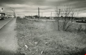
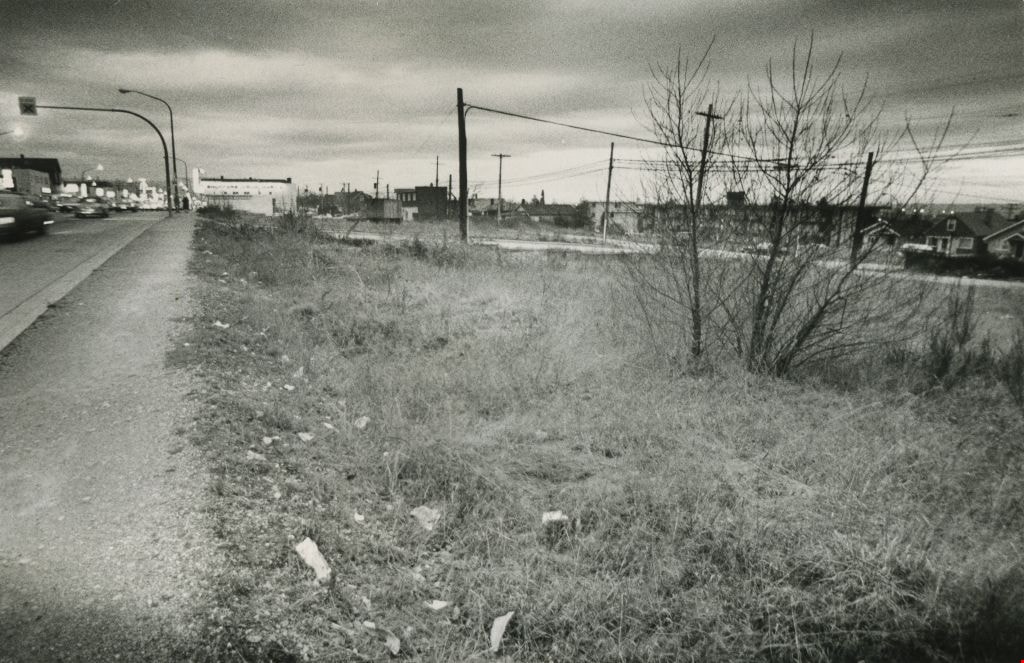
Vacant land
https://search.heritageburnaby.ca/link/archivedescription45418
- Repository
- City of Burnaby Archives
- Date
- February 1977
- Collection/Fonds
- Columbian Newspaper collection
- Description Level
- Item
- Physical Description
- 1 photograph : b&w ; 9 x 14 cm
- Scope and Content
- Photograph of vacant land, believed to be the 3900 block of Hastings, owned by the municipality.
- Repository
- City of Burnaby Archives
- Date
- February 1977
- Collection/Fonds
- Columbian Newspaper collection
- Physical Description
- 1 photograph : b&w ; 9 x 14 cm
- Description Level
- Item
- Record No.
- 480-313
- Access Restriction
- No restrictions
- Reproduction Restriction
- No restrictions
- Accession Number
- 2003-02
- Scope and Content
- Photograph of vacant land, believed to be the 3900 block of Hastings, owned by the municipality.
- Media Type
- Photograph
- Photographer
- Battistoni, Peter
- Notes
- Title based on contents of photograph
- Geographic Access
- Hastings Street
- Historic Neighbourhood
- Vancouver Heights (Historic Neighbourhood)
- Planning Study Area
- Burnaby Heights Area
Images

6113 Silver Avenue lot
https://search.heritageburnaby.ca/link/archivedescription37775
- Repository
- City of Burnaby Archives
- Date
- 1986 (date of original), copied 1991
- Collection/Fonds
- Burnaby Historical Society fonds
- Description Level
- Item
- Physical Description
- 1 photograph : b&w ; 3.1 x 4.4 cm print on contact sheet 20.3 x 26.2 cm
- Scope and Content
- Photograph of the lot at 6113 Silver Avenue, the former home of the Ellis family. The house has been demolished and an empty lot remains. Houses, aparment buildings, and the Expo line skytrain track with cars on it can be seen in the background.
- Repository
- City of Burnaby Archives
- Date
- 1986 (date of original), copied 1991
- Collection/Fonds
- Burnaby Historical Society fonds
- Subseries
- Burnaby Image Bank subseries
- Physical Description
- 1 photograph : b&w ; 3.1 x 4.4 cm print on contact sheet 20.3 x 26.2 cm
- Description Level
- Item
- Record No.
- 370-363
- Access Restriction
- No restrictions
- Reproduction Restriction
- No restrictions
- Accession Number
- BHS1999-03
- Scope and Content
- Photograph of the lot at 6113 Silver Avenue, the former home of the Ellis family. The house has been demolished and an empty lot remains. Houses, aparment buildings, and the Expo line skytrain track with cars on it can be seen in the background.
- Subjects
- Land Clearing
- Media Type
- Photograph
- Notes
- Title based on contents of photograph
- 1 b&w copy negative accompanying
- Negative has a pink cast
- Copied from col. photograph
- Geographic Access
- Silver Avenue
- Street Address
- 6113 Silver Avenue
- Historic Neighbourhood
- Central Park (Historic Neighbourhood)
- Planning Study Area
- Maywood Area
Images

![Ada Bingham by a tree stump, [1948] thumbnail](/media/hpo/_Data/_BVM_Images/1976/1976_0046_0005_001.jpg?width=280)
Ada Bingham by a tree stump
https://search.heritageburnaby.ca/link/museumdescription739
- Repository
- Burnaby Village Museum
- Date
- [1948]
- Collection/Fonds
- Burnaby Village Museum Photograph collection
- Description Level
- Item
- Physical Description
- 1 photograph : b&w ; 11.3 x 6.8 cm
- Scope and Content
- Photograph of Mary Ada Bingham standing in front of a giant tree stump in Willingdon Heights which was to be cleared for a veterans' housing project in 1948. According to an accompanying note prepared by Burnaby Village Museum, and supported by the inscription on the photograph, Ada Bingham came to…
- Repository
- Burnaby Village Museum
- Collection/Fonds
- Burnaby Village Museum Photograph collection
- Description Level
- Item
- Physical Description
- 1 photograph : b&w ; 11.3 x 6.8 cm
- Material Details
- Inscribed in black ballpoint pen, on the back of the photo: "Ada and Big Stump / Clearing time on Willingdon Heights / 1948. / Burnaby 2. B. C" and in blue ballpoint pen: "Mrs. Mary Ada Bingham / 1 Real Pioneer Wife; she helped me clear the land. Build our home, dig out well and worked for the community for nearly 50 years. She died August 9, 1969 / Alf Bingham."
- Scope and Content
- Photograph of Mary Ada Bingham standing in front of a giant tree stump in Willingdon Heights which was to be cleared for a veterans' housing project in 1948. According to an accompanying note prepared by Burnaby Village Museum, and supported by the inscription on the photograph, Ada Bingham came to Burnaby to homestead with her husband, Alfred "Alf" Bingham, in 1919. They settled in the Lochdale district of North Burnaby but later moved to Parker Street.
- Subjects
- Land Clearing
- Plants - Trees
- Names
- Bingham, Mary Ada "Ada"
- Accession Code
- HV976.46.5
- Access Restriction
- No restrictions
- Reproduction Restriction
- No known restrictions
- Date
- [1948]
- Media Type
- Photograph
- Historic Neighbourhood
- Vancouver Heights (Historic Neighbourhood)
- Planning Study Area
- Willingdon Heights Area
- Scan Resolution
- 600
- Scan Date
- 2023-06-20
- Notes
- Title based on contents of photograph
Images
![Ada Bingham by a tree stump, [1948] thumbnail](/media/hpo/_Data/_BVM_Images/1976/1976_0046_0005_001.jpg)
![Aerial photograph of Burnaby Mountain, [1957 or 1958] thumbnail](/media/hpo/_Data/_Archives_Images/_Unrestricted/371/476-025.jpg?width=280)
Aerial photograph of Burnaby Mountain
https://search.heritageburnaby.ca/link/archivedescription39742
- Repository
- City of Burnaby Archives
- Date
- [1957 or 1958]
- Collection/Fonds
- Burnaby Historical Society fonds
- Description Level
- Item
- Physical Description
- 1 photograph : b&w ; 14 x 14 cm
- Scope and Content
- Aerial photograph of the Burnaby Mountain park and Centennial Pavilion, under construction.
- Repository
- City of Burnaby Archives
- Date
- [1957 or 1958]
- Collection/Fonds
- Burnaby Historical Society fonds
- Subseries
- North Burnaby Board of Trade subseries
- Physical Description
- 1 photograph : b&w ; 14 x 14 cm
- Description Level
- Item
- Record No.
- 476-025
- Access Restriction
- No restrictions
- Reproduction Restriction
- Reproduce for fair dealing purposes only
- Accession Number
- BHS2005-8
- Scope and Content
- Aerial photograph of the Burnaby Mountain park and Centennial Pavilion, under construction.
- Subjects
- Aerial Photographs
- Land Clearing
- Media Type
- Photograph
- Photographer
- Hunting Survey Corporation Limited
- Notes
- Title based on contents of photograph.
- Geographic Access
- Burnaby Mountain Conservation Area
- Centennial Way
- Street Address
- 100 Centennial Way
- Planning Study Area
- Burnaby Mountain Area
Images
![Aerial photograph of Burnaby Mountain, [1957 or 1958] thumbnail](/media/hpo/_Data/_Archives_Images/_Unrestricted/371/476-025.jpg)

Alfred Bingham
https://search.heritageburnaby.ca/link/archivedescription34149
- Repository
- City of Burnaby Archives
- Date
- April 20, 1947
- Collection/Fonds
- Burnaby Historical Society fonds
- Description Level
- Item
- Physical Description
- 1 photograph : b&w negative ; 11.3 x 6.8 cm
- Scope and Content
- Photograph of Alfred "Alf" Bingham standing in front of a fir tree stump that is approximately 400 years old on the 4200 block of Kitchener Street. This is part of the Willingdon Heights subdivision site.
- Repository
- City of Burnaby Archives
- Date
- April 20, 1947
- Collection/Fonds
- Burnaby Historical Society fonds
- Subseries
- Alfred Bingham subseries
- Physical Description
- 1 photograph : b&w negative ; 11.3 x 6.8 cm
- Description Level
- Item
- Record No.
- 010-066
- Access Restriction
- No restrictions
- Reproduction Restriction
- Reproduce for fair dealing purposes only
- Accession Number
- BHS2007-04
- Scope and Content
- Photograph of Alfred "Alf" Bingham standing in front of a fir tree stump that is approximately 400 years old on the 4200 block of Kitchener Street. This is part of the Willingdon Heights subdivision site.
- Subjects
- Land Clearing
- Plants - Trees
- Names
- Bingham, Alfred "Alf"
- Media Type
- Photograph
- Photographer
- Bingham, Alfred "Alf"
- Notes
- Title based on contents of photograph
- Geographic Access
- Kitchener Street
Images
