Narrow Results By
Subject
- Agriculture - Farms 1
- Animals - Horses 1
- Buildings - Residential - Boathouses 1
- Construction 1
- Geographic Features - Creeks 5
- Geographic Features - Lakes and Ponds 1
- Geographic Features - Rivers 1
- Land Clearing 4
- Natural Phenomena - Floods 3
- Natural Phenomena - Snow 2
- Occupations - Labourers 1
- Structures - Bridges 2
![Boathouse on Burnaby Lake, [1902] thumbnail](/media/hpo/_Data/_Archives_Images/_Unrestricted/477/477-855.jpg?width=280)
Boathouse on Burnaby Lake
https://search.heritageburnaby.ca/link/archivedescription39536
- Repository
- City of Burnaby Archives
- Date
- [1902]
- Collection/Fonds
- Peers Family and Hill Family fonds
- Description Level
- Item
- Physical Description
- 1 photograph : b&w 5.5 x 7.5 cm on page 21.5 x 28 cm (pasted in album)
- Scope and Content
- Photograph of Bernard Hill's boathouse on Burnaby Lake. Built in 1902, the boathouse was located on Deer Lake Brook at the southwestern tip of Burnaby Lake.
- Repository
- City of Burnaby Archives
- Date
- [1902]
- Collection/Fonds
- Peers Family and Hill Family fonds
- Physical Description
- 1 photograph : b&w 5.5 x 7.5 cm on page 21.5 x 28 cm (pasted in album)
- Description Level
- Item
- Record No.
- 477-855
- Access Restriction
- No restrictions
- Reproduction Restriction
- No known restrictions
- Accession Number
- 2007-12
- Scope and Content
- Photograph of Bernard Hill's boathouse on Burnaby Lake. Built in 1902, the boathouse was located on Deer Lake Brook at the southwestern tip of Burnaby Lake.
- Subjects
- Buildings - Residential - Boathouses
- Media Type
- Photograph
- Notes
- Title based on caption accompanying photograph
- Geographic Access
- Burnaby Lake
- Deer Lake Brook
- Historic Neighbourhood
- Burnaby Lake (Historic Neighbourhood)
Images
![Boathouse on Burnaby Lake, [1902] thumbnail](/media/hpo/_Data/_Archives_Images/_Unrestricted/477/477-855.jpg)

Bridge over Deer Lake Brook
https://search.heritageburnaby.ca/link/archivedescription39323
- Repository
- City of Burnaby Archives
- Date
- 1922
- Collection/Fonds
- Peers Family and Hill Family fonds
- Description Level
- Item
- Physical Description
- 1 photograph : b&w ; 6.2 x 9.8 cm on page 24.5 x 32.5 cm (pasted in album)
- Scope and Content
- Photograph of a bridge over Deer Lake Brook, covered with snow. This photograph was probably taken on the property belonging to Claude Hill, known as "Brookfield."
- Repository
- City of Burnaby Archives
- Date
- 1922
- Collection/Fonds
- Peers Family and Hill Family fonds
- Physical Description
- 1 photograph : b&w ; 6.2 x 9.8 cm on page 24.5 x 32.5 cm (pasted in album)
- Description Level
- Item
- Record No.
- 477-642
- Access Restriction
- No restrictions
- Reproduction Restriction
- No known restrictions
- Accession Number
- 2007-12
- Scope and Content
- Photograph of a bridge over Deer Lake Brook, covered with snow. This photograph was probably taken on the property belonging to Claude Hill, known as "Brookfield."
- Media Type
- Photograph
- Notes
- Title based on contents of photograph
- Geographic Access
- Deer Lake Brook
- Deer Lake Avenue
- Street Address
- 6501 Deer Lake Avenue
- Historic Neighbourhood
- Burnaby Lake (Historic Neighbourhood)
- Planning Study Area
- Morley-Buckingham Area
Images


Camp at Oakalla Site
https://search.heritageburnaby.ca/link/archivedescription39575
- Repository
- City of Burnaby Archives
- Date
- 1910
- Collection/Fonds
- Peers Family and Hill Family fonds
- Description Level
- Item
- Physical Description
- 1 photograph : b&w ; 7.7 x 10.4 cm on page 21.5 x 28 cm (pasted in album)
- Scope and Content
- Photograph of the land clearing operation at the Oakalla Prison site in the Deer Lake area. Claude Hill is in the centre between two unidentified men. A line of clothes is hanging in the background.
- Repository
- City of Burnaby Archives
- Date
- 1910
- Collection/Fonds
- Peers Family and Hill Family fonds
- Physical Description
- 1 photograph : b&w ; 7.7 x 10.4 cm on page 21.5 x 28 cm (pasted in album)
- Description Level
- Item
- Record No.
- 477-894
- Access Restriction
- No restrictions
- Reproduction Restriction
- No known restrictions
- Accession Number
- 2007-12
- Scope and Content
- Photograph of the land clearing operation at the Oakalla Prison site in the Deer Lake area. Claude Hill is in the centre between two unidentified men. A line of clothes is hanging in the background.
- Subjects
- Land Clearing
- Media Type
- Photograph
- Notes
- Title based on contents of photograph
- Geographic Access
- Oakmount Crescent
- Street Address
- 5220 Oakmount Crescent
- Historic Neighbourhood
- Burnaby Lake (Historic Neighbourhood)
- Planning Study Area
- Oakalla Area
Images


Clearing Land for Oakalla Prison Farm
https://search.heritageburnaby.ca/link/archivedescription39574
- Repository
- City of Burnaby Archives
- Date
- 1910
- Collection/Fonds
- Peers Family and Hill Family fonds
- Description Level
- Item
- Physical Description
- 1 photograph : b&w ; 7.7 x 10.3 cm on page 21.5 x 28 cm (pasted in album)
- Scope and Content
- Photograph of the Oakalla Prison Farm site being cleared in the Deer Lake area. Claude Hill is to the far right but the other man is unidentified.
- Repository
- City of Burnaby Archives
- Date
- 1910
- Collection/Fonds
- Peers Family and Hill Family fonds
- Physical Description
- 1 photograph : b&w ; 7.7 x 10.3 cm on page 21.5 x 28 cm (pasted in album)
- Description Level
- Item
- Record No.
- 477-893
- Access Restriction
- No restrictions
- Reproduction Restriction
- No known restrictions
- Accession Number
- 2007-12
- Scope and Content
- Photograph of the Oakalla Prison Farm site being cleared in the Deer Lake area. Claude Hill is to the far right but the other man is unidentified.
- Subjects
- Land Clearing
- Media Type
- Photograph
- Notes
- Title based on contents of photograph
- Geographic Access
- Oakmount Crescent
- Street Address
- 5220 Oakmount Crescent
- Historic Neighbourhood
- Burnaby Lake (Historic Neighbourhood)
- Planning Study Area
- Oakalla Area
Images

Construction at the Oakalla Site
https://search.heritageburnaby.ca/link/archivedescription39580
- Repository
- City of Burnaby Archives
- Date
- 1910
- Collection/Fonds
- Peers Family and Hill Family fonds
- Description Level
- Item
- Physical Description
- 1 photograph : b&w ; 7.8 x 10 cm on page 21.5 x 28 cm (pasted in album)
- Scope and Content
- Photograph of construction work and land clearing at the site of the Oakalla Prison farm in the Deer Lake area. Three unidentified men can be seen standing in the background to the left.
- Repository
- City of Burnaby Archives
- Date
- 1910
- Collection/Fonds
- Peers Family and Hill Family fonds
- Physical Description
- 1 photograph : b&w ; 7.8 x 10 cm on page 21.5 x 28 cm (pasted in album)
- Description Level
- Item
- Record No.
- 477-899
- Access Restriction
- No restrictions
- Reproduction Restriction
- No known restrictions
- Accession Number
- 2007-12
- Scope and Content
- Photograph of construction work and land clearing at the site of the Oakalla Prison farm in the Deer Lake area. Three unidentified men can be seen standing in the background to the left.
- Subjects
- Construction
- Land Clearing
- Names
- Oakalla Prison Farm
- Media Type
- Photograph
- Notes
- Title based on contents of photograph
- Geographic Access
- Oakmount Crescent
- Street Address
- 5220 Oakmount Crescent
- Historic Neighbourhood
- Burnaby Lake (Historic Neighbourhood)
- Planning Study Area
- Oakalla Area
Images

Deer Lake Brook
https://search.heritageburnaby.ca/link/archivedescription39321
- Repository
- City of Burnaby Archives
- Date
- 1922
- Collection/Fonds
- Peers Family and Hill Family fonds
- Description Level
- Item
- Physical Description
- 1 photograph : b&w ; 6 x 9.8 cm on page 24.5 x 32.5 cm (pasted in album)
- Scope and Content
- Photograph of Deer Lake Creek; historically known as Deer Lake Brook. The banks and trees are covered with snow.
- Repository
- City of Burnaby Archives
- Date
- 1922
- Collection/Fonds
- Peers Family and Hill Family fonds
- Physical Description
- 1 photograph : b&w ; 6 x 9.8 cm on page 24.5 x 32.5 cm (pasted in album)
- Description Level
- Item
- Record No.
- 477-640
- Access Restriction
- No restrictions
- Reproduction Restriction
- No known restrictions
- Accession Number
- 2007-12
- Scope and Content
- Photograph of Deer Lake Creek; historically known as Deer Lake Brook. The banks and trees are covered with snow.
- Media Type
- Photograph
- Notes
- Title based on contents of photograph
- Geographic Access
- Deer Lake Brook
Images

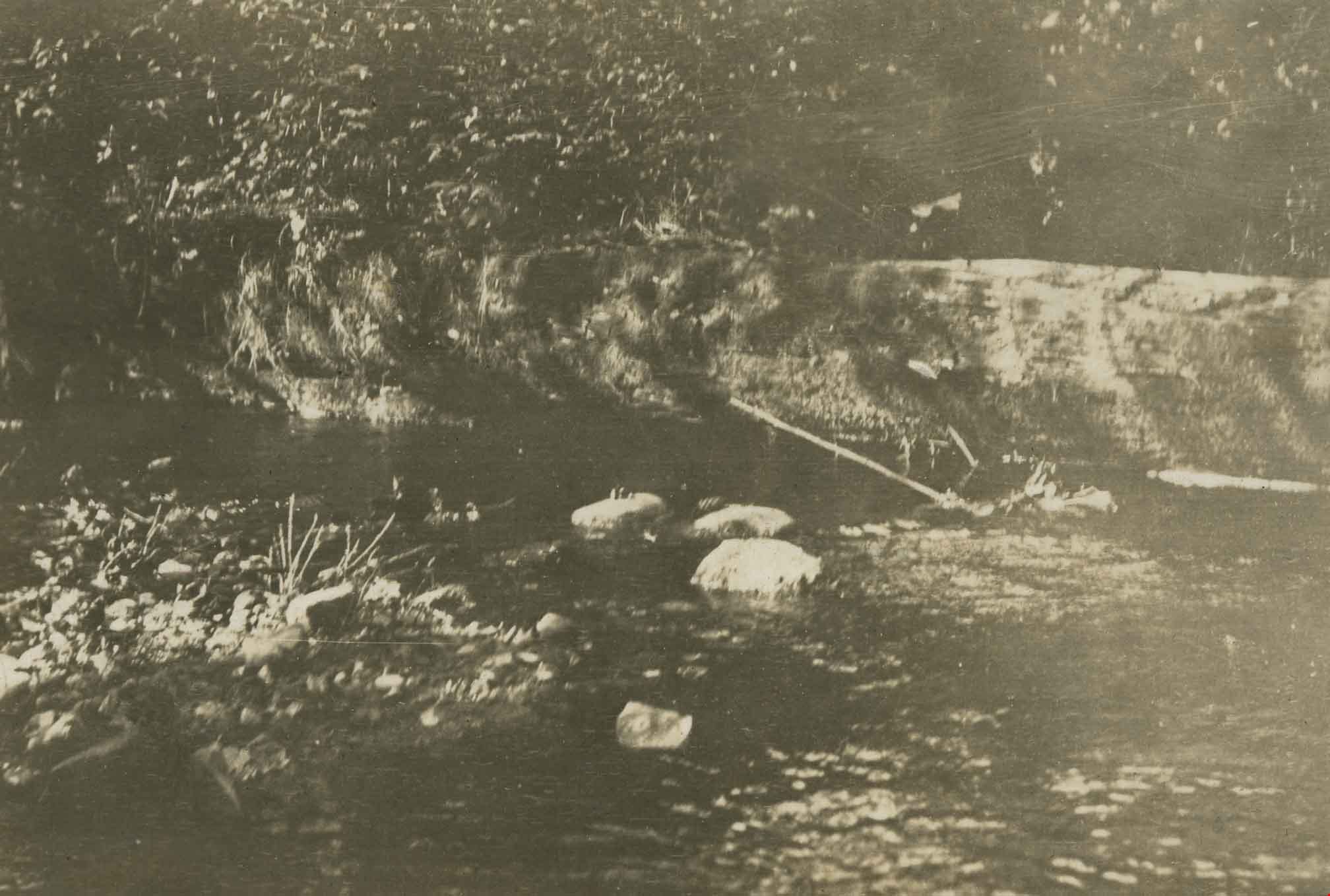
Deer Lake Brook
https://search.heritageburnaby.ca/link/archivedescription39322
- Repository
- City of Burnaby Archives
- Date
- 1922
- Collection/Fonds
- Peers Family and Hill Family fonds
- Description Level
- Item
- Physical Description
- 1 photograph : b&w ; 5.8 x 8.5 cm on page 24.5 x 32.5 cm (pasted in album)
- Scope and Content
- Photograph of Deer Lake Creek, historically known as Deer Lake Brook.
- Repository
- City of Burnaby Archives
- Date
- 1922
- Collection/Fonds
- Peers Family and Hill Family fonds
- Physical Description
- 1 photograph : b&w ; 5.8 x 8.5 cm on page 24.5 x 32.5 cm (pasted in album)
- Description Level
- Item
- Record No.
- 477-641
- Access Restriction
- No restrictions
- Reproduction Restriction
- No known restrictions
- Accession Number
- 2007-12
- Scope and Content
- Photograph of Deer Lake Creek, historically known as Deer Lake Brook.
- Subjects
- Geographic Features - Creeks
- Media Type
- Photograph
- Notes
- Title based on contents of photograph
- Geographic Access
- Deer Lake Brook
Images

Deer Lake Brook in flood
https://search.heritageburnaby.ca/link/archivedescription39387
- Repository
- City of Burnaby Archives
- Date
- 1916
- Collection/Fonds
- Peers Family and Hill Family fonds
- Description Level
- Item
- Physical Description
- 1 photograph : b&w ; 6 x 10.4 cm on page 24.5 x 32.5 cm (pasted in album)
- Scope and Content
- Photograph of Deer Lake Creek; historically known as Deer Lake Brook, during a flood.
- Repository
- City of Burnaby Archives
- Date
- 1916
- Collection/Fonds
- Peers Family and Hill Family fonds
- Physical Description
- 1 photograph : b&w ; 6 x 10.4 cm on page 24.5 x 32.5 cm (pasted in album)
- Description Level
- Item
- Record No.
- 477-706
- Access Restriction
- No restrictions
- Reproduction Restriction
- No known restrictions
- Accession Number
- 2007-12
- Scope and Content
- Photograph of Deer Lake Creek; historically known as Deer Lake Brook, during a flood.
- Media Type
- Photograph
- Notes
- Title based on caption accompanying photograph
- Geographic Access
- Deer Lake Brook
- Historic Neighbourhood
- Burnaby Lake (Historic Neighbourhood)
Images


Deer Lake Brook in flood
https://search.heritageburnaby.ca/link/archivedescription39389
- Repository
- City of Burnaby Archives
- Date
- 1916
- Collection/Fonds
- Peers Family and Hill Family fonds
- Description Level
- Item
- Physical Description
- 1 photograph : b&w ; 6 x 9.8 cm on page 24.5 x 32.5 cm (pasted in album)
- Scope and Content
- Photograph of Deer Lake Creek; historically known as Deer Lake Creek, in flood.
- Repository
- City of Burnaby Archives
- Date
- 1916
- Collection/Fonds
- Peers Family and Hill Family fonds
- Physical Description
- 1 photograph : b&w ; 6 x 9.8 cm on page 24.5 x 32.5 cm (pasted in album)
- Description Level
- Item
- Record No.
- 477-708
- Access Restriction
- No restrictions
- Reproduction Restriction
- No known restrictions
- Accession Number
- 2007-12
- Scope and Content
- Photograph of Deer Lake Creek; historically known as Deer Lake Creek, in flood.
- Media Type
- Photograph
- Notes
- Title based on caption accompanying photograph
- Geographic Access
- Deer Lake Brook
- Historic Neighbourhood
- Burnaby Lake (Historic Neighbourhood)
Images

![E.B. Wetenhall and Kitty Hill, [1902] thumbnail](/media/hpo/_Data/_Archives_Images/_Unrestricted/477/477-100.jpg?width=280)
E.B. Wetenhall and Kitty Hill
https://search.heritageburnaby.ca/link/archivedescription38781
- Repository
- City of Burnaby Archives
- Date
- [1902]
- Collection/Fonds
- Peers Family and Hill Family fonds
- Description Level
- Item
- Physical Description
- 1 photograph : b&w ; 6 x 8 cm on page 11.5 x 14 cm (pasted in album)
- Scope and Content
- Photograph of E.B. Wetenhall leading a horse to water. Kitty Hill is the foreground and a wooden trestle bridge spans Deer Lake Brook in the background.
- Repository
- City of Burnaby Archives
- Date
- [1902]
- Collection/Fonds
- Peers Family and Hill Family fonds
- Physical Description
- 1 photograph : b&w ; 6 x 8 cm on page 11.5 x 14 cm (pasted in album)
- Description Level
- Item
- Record No.
- 477-100
- Access Restriction
- No restrictions
- Reproduction Restriction
- No known restrictions
- Accession Number
- 2007-12
- Scope and Content
- Photograph of E.B. Wetenhall leading a horse to water. Kitty Hill is the foreground and a wooden trestle bridge spans Deer Lake Brook in the background.
- Media Type
- Photograph
- Notes
- Title based on contents of photograph
- Geographic Access
- Deer Lake Brook
- Deer Lake Avenue
- Street Address
- 6501 Deer Lake Avenue
- Historic Neighbourhood
- Burnaby Lake (Historic Neighbourhood)
- Planning Study Area
- Morley-Buckingham Area
Images
![E.B. Wetenhall and Kitty Hill, [1902] thumbnail](/media/hpo/_Data/_Archives_Images/_Unrestricted/477/477-100.jpg)

Looking south from Bernard Hill's house
https://search.heritageburnaby.ca/link/archivedescription39527
- Repository
- City of Burnaby Archives
- Date
- 1906
- Collection/Fonds
- Peers Family and Hill Family fonds
- Description Level
- Item
- Physical Description
- 1 photograph : b&w ; 11.8 x 17 cm on page 21.5 x 28 cm (pasted in album)
- Scope and Content
- Photograph of the fields and farmland looking southeast from the home of Bernard Hill down Douglas Road towards Deer Lake Brook. In the foreground view can be seen what is the present-day Kensington Avenue freeway entrance and No. 1 Firehall site on Sperling Avenue. The cabin that can be seen to …
- Repository
- City of Burnaby Archives
- Date
- 1906
- Collection/Fonds
- Peers Family and Hill Family fonds
- Physical Description
- 1 photograph : b&w ; 11.8 x 17 cm on page 21.5 x 28 cm (pasted in album)
- Description Level
- Item
- Record No.
- 477-846
- Access Restriction
- No restrictions
- Reproduction Restriction
- No known restrictions
- Accession Number
- 2007-12
- Scope and Content
- Photograph of the fields and farmland looking southeast from the home of Bernard Hill down Douglas Road towards Deer Lake Brook. In the foreground view can be seen what is the present-day Kensington Avenue freeway entrance and No. 1 Firehall site on Sperling Avenue. The cabin that can be seen to the left in the background is an unknown residence further along Douglas Road near Rayside Drive and the cabin that is just visible in the centre background of the photograph (between treeline split) belonged to Mr. Nicholson. It was later torn down when Bernard Hill's brother Claude Hill built his home, Broadview at that location. To the extreme right of the picture on the opposite side of Douglas Road is the property of Claude Hill's first Burnaby home also known as Brookfield (the current location of the Burnaby Village Museum).
- Subjects
- Agriculture - Farms
- Media Type
- Photograph
- Notes
- Title based on caption accompanying photograph
- Geographic Access
- Douglas Road
- Canada Way
- Deer Lake Brook
- Street Address
- 4990 Canada Way
- Historic Neighbourhood
- Burnaby Lake (Historic Neighbourhood)
- Planning Study Area
- Douglas-Gilpin Area
Images


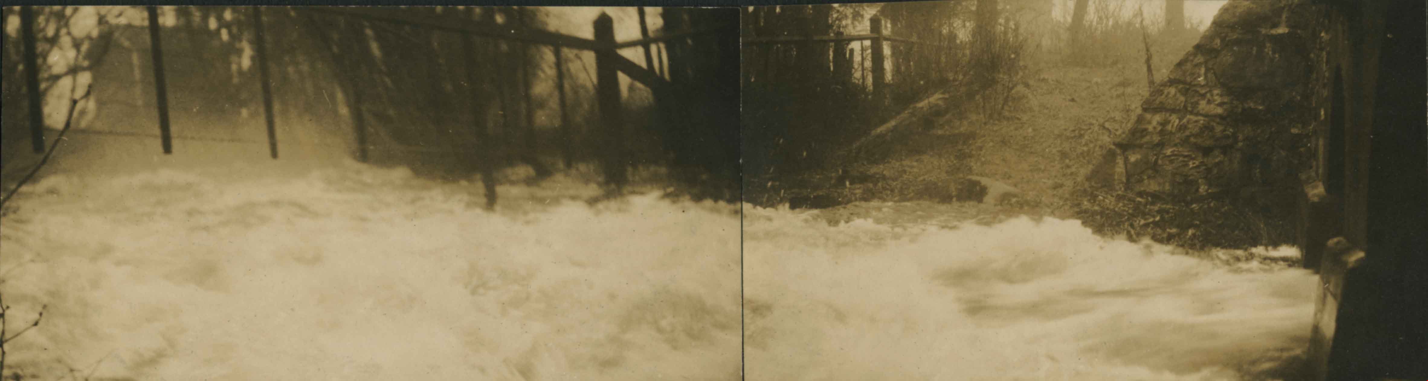
Panorama of Deer Lake Brook in flood
https://search.heritageburnaby.ca/link/archivedescription39388
- Repository
- City of Burnaby Archives
- Date
- 1916
- Collection/Fonds
- Peers Family and Hill Family fonds
- Description Level
- Item
- Physical Description
- 2 photographs : sepia panorama ; 5.5 x 10.4 cm on page 24.5 x 32.5 cm (pasted in album)
- Scope and Content
- Photographic panorama of Deer Lake Creek; historically known as Deer Lake Brook, in flood.
- Repository
- City of Burnaby Archives
- Date
- 1916
- Collection/Fonds
- Peers Family and Hill Family fonds
- Physical Description
- 2 photographs : sepia panorama ; 5.5 x 10.4 cm on page 24.5 x 32.5 cm (pasted in album)
- Description Level
- Item
- Record No.
- 477-707
- Access Restriction
- No restrictions
- Reproduction Restriction
- No known restrictions
- Accession Number
- 2007-12
- Scope and Content
- Photographic panorama of Deer Lake Creek; historically known as Deer Lake Brook, in flood.
- Media Type
- Photograph
- Notes
- Title based on caption accompanying photograph
- Geographic Access
- Deer Lake Brook
- Historic Neighbourhood
- Burnaby Lake (Historic Neighbourhood)
Images
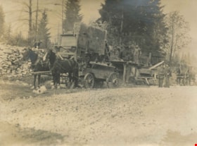
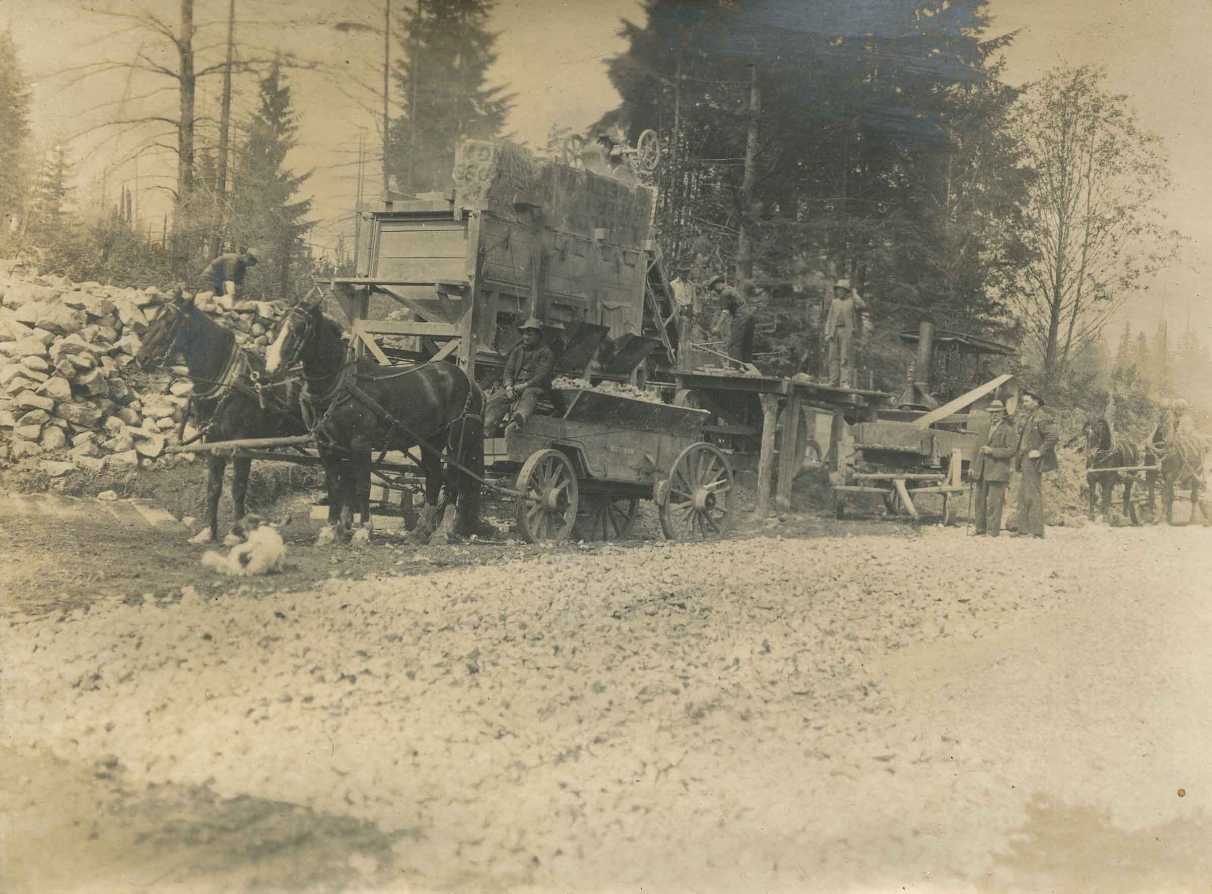
Rock crusher in operation
https://search.heritageburnaby.ca/link/archivedescription39573
- Repository
- City of Burnaby Archives
- Date
- August 1910
- Collection/Fonds
- Peers Family and Hill Family fonds
- Description Level
- Item
- Physical Description
- 1 photograph : b&w ; 7.5 x 10.2 cm on page 21.5 x 28 cm (pasted in album)
- Scope and Content
- Photograph of a rock crusher in operation. From a wall of rocks, a team of men puts the rock into the rock crusher. The crushed gravel is loaded up in a horse drawn cart, with a driver ready to transport it away. There are two men in suits to the right of the photograph watching the operation.
- Repository
- City of Burnaby Archives
- Date
- August 1910
- Collection/Fonds
- Peers Family and Hill Family fonds
- Physical Description
- 1 photograph : b&w ; 7.5 x 10.2 cm on page 21.5 x 28 cm (pasted in album)
- Description Level
- Item
- Record No.
- 477-892
- Access Restriction
- No restrictions
- Reproduction Restriction
- No known restrictions
- Accession Number
- 2007-12
- Scope and Content
- Photograph of a rock crusher in operation. From a wall of rocks, a team of men puts the rock into the rock crusher. The crushed gravel is loaded up in a horse drawn cart, with a driver ready to transport it away. There are two men in suits to the right of the photograph watching the operation.
- Names
- Oakalla Prison Farm
- Media Type
- Photograph
- Notes
- Title based on contents of photograph
- Geographic Access
- Oakmount Crescent
- Street Address
- 5220 Oakmount Crescent
- Historic Neighbourhood
- Burnaby Lake (Historic Neighbourhood)
- Planning Study Area
- Oakalla Area
Images