Narrow Results By
Subject
- Buildings - Schools 1
- Celebrations 3
- Documentary Artifacts - Books 1
- Documentary Artifacts - Postcards 2
- Geographic Features - Roads 1
- Geographic Features - Sidewalks 1
- Occupations - Teachers 7
- Organizations - Girls' Societies and Clubs 3
- Persons - Students 5
- Sports - Grass Hockey 1
- Sports - Team Sports 1
- Transportation - Bicycles 1

A.E. Brown Residence
https://search.heritageburnaby.ca/link/landmark553
- Repository
- Burnaby Heritage Planning
- Description
- Residential building.
- Associated Dates
- 1924
- Street View URL
- Google Maps Street View
- Repository
- Burnaby Heritage Planning
- Geographic Access
- Sperling Avenue
- Associated Dates
- 1924
- Description
- Residential building.
- Heritage Value
- Built after the end of the First World War, this house features an eclectic blend of Arts and Crafts elements. Constructed for A.E. Brown and a full two storeys in height, it has a front jerkin-headed roof with a jerkin-headed side projection, and a corner wraparound verandah with tapered columns. The house has been maintained in near original condition, with original lapped wooden siding, multi-paned windows and square balusters.
- Locality
- Edmonds
- Historic Neighbourhood
- Edmonds (Historic Neighbourhood)
- Planning Study Area
- Kingsway-Beresford Area
- Ownership
- Private
- Street Address
- 6830 Sperling Avenue
- Street View URL
- Google Maps Street View
Images


Brantford Elementary School
https://search.heritageburnaby.ca/link/landmark809
- Repository
- Burnaby Heritage Planning
- Geographic Access
- Brantford Avenue
- Associated Dates
- 1965
- Heritage Value
- As housing developments extended north from Kingsway, pupil enrolments grew at Windsor and at Morley Schools so Brantford was built equidistant from the two to help ease enrolment problems. Brantford Elementary school opened in 1965 and was similar in structure to other schools built in Burnaby during this period - no basements, no second stories and no high stairways. Classrooms were built in a line and could easily be added to as enrolments increased. Brantford had room additions in 1969.
- Historic Neighbourhood
- Edmonds (Historic Neighbourhood)
- Planning Study Area
- Kingsway-Beresford Area
- Street Address
- 6512 Brantford Avenue
- Street View URL
- Google Maps Street View
Images


Burnaby South High School
https://search.heritageburnaby.ca/link/landmark770
- Repository
- Burnaby Heritage Planning
- Associated Dates
- 1922-1988
- Street View URL
- Google Maps Street View
- Repository
- Burnaby Heritage Planning
- Geographic Access
- Southoaks Crescent
- Associated Dates
- 1922-1988
- Heritage Value
- Burnaby South and Burnaby North were Burnaby's first high schools. The first rooms of the school were built in 1922 on the same grounds as the Kingsway East Elementary School. In 1940, a two-storey building was erected and additions were made in 1963, 1967 and 1972. Kingsway East closed in 1925 and its buildings were used by the high school for Industrial Arts and Home Economics. In the early 1990s, a new "urban education centre" (Burnaby South/B.C. School for the Deaf) was opened, replacing the old Burnaby South High School.
- Historic Neighbourhood
- Edmonds (Historic Neighbourhood)
- Planning Study Area
- Kingsway-Beresford Area
- Street Address
- 6650 Southoaks Crescent
- Street View URL
- Google Maps Street View
Images


Burnaby South High School Cenotaph & Memorial Tennis Courts
https://search.heritageburnaby.ca/link/landmark547
- Repository
- Burnaby Heritage Planning
- Description
- This memorial comprises a cenotaph and three tennis courts: the former a monument of British Columbia granite inscribed with the names of fifty-one students of Burnaby South High School who lost their lives in the Second World War; and the latter a living memorial to these former students.
- Associated Dates
- 1948
- Formal Recognition
- Heritage Designation, Community Heritage Register
- Street View URL
- Google Maps Street View
- Repository
- Burnaby Heritage Planning
- Geographic Access
- Southoaks Crescent
- Associated Dates
- 1948
- Formal Recognition
- Heritage Designation, Community Heritage Register
- Enactment Type
- Bylaw No. 9807
- Enactment Date
- 23/11/1992
- Description
- This memorial comprises a cenotaph and three tennis courts: the former a monument of British Columbia granite inscribed with the names of fifty-one students of Burnaby South High School who lost their lives in the Second World War; and the latter a living memorial to these former students.
- Heritage Value
- This memorial is important for its spiritual, symbolic, and cultural associations for the former students of Burnaby South High School, and for all youth in the community. The cenotaph is of personal significance to the families of those who lost their lives. The unusual combination of cenotaph and living memorial - the tennis courts - represents a rare statement of a community's commitment to not allow the sacrifice of its youth to be forgotten by providing an active facility which draw people to the place on a regular basis rather than just on occasions of remembrance. As such it is an important symbol of a humanitarian ethic. In combination with the Kingsway East School, now rehabilitated as the Alan Emmott Centre, this memorial represents a valuable haven of green-space and recreation in the high-density urban development that now surrounds it.
- Defining Elements
- Key elements that define the heritage character of the Burnaby South High School Cenotaph & Memorial Tennis Courts include the: - location of the cenotaph adjacent to the living memorial - spatial association of this memorial and the remaining school building - physical fabric of both the granite monument and the tennis courts
- Historic Neighbourhood
- Edmonds (Historic Neighbourhood)
- Planning Study Area
- Kingsway-Beresford Area
- Function
- Primary Current--Public Feature
- Primary Historic--Public Feature
- Community
- Burnaby
- Cadastral Identifier
- P.I.D. No. 016-367-154 Legal Description: Lot 1, District Lot 96, Group 1 New Westminster District, Plan 86581
- Boundaries
- Burnaby South High School Cenotaph & Memorial Tennis Courts is comprised of a single municipally-owned property located at 6650 Southoaks Crescent, Burnaby.
- Area
- 6,070.00
- Contributing Resource
- Building
- Landscape Feature
- Structure
- Ownership
- Public (local)
- Documentation
- Heritage Site Files: PC77000 20. City of Burnaby Planning and Building Department, 4949 Canada Way, Burnaby, B.C., V5G 1M2
- Street Address
- 6650 Southoaks Crescent
- Street View URL
- Google Maps Street View
Images


Jacob & Margaret Wysong House
https://search.heritageburnaby.ca/link/landmark507
- Repository
- Burnaby Heritage Planning
- Description
- The Jacob and Margaret Wysong House is a two and one-half storey, wood-frame Arts and Crafts house with a hipped roof and hipped dormers. Symmetrical in massing, it is distinguished by its masonry verandah columns, foundations and chimneys. It is located on a corner lot on Sperling Avenue at Stanle…
- Associated Dates
- 1912
- Formal Recognition
- Heritage Designation, Community Heritage Register
- Street View URL
- Google Maps Street View
- Repository
- Burnaby Heritage Planning
- Geographic Access
- Sperling Avenue
- Associated Dates
- 1912
- Formal Recognition
- Heritage Designation, Community Heritage Register
- Enactment Type
- By-law No. 11978
- Enactment Date
- 17/10/2005
- Description
- The Jacob and Margaret Wysong House is a two and one-half storey, wood-frame Arts and Crafts house with a hipped roof and hipped dormers. Symmetrical in massing, it is distinguished by its masonry verandah columns, foundations and chimneys. It is located on a corner lot on Sperling Avenue at Stanley Street in the Edmonds neighbourhood of South Burnaby.
- Heritage Value
- The Jacob and Margaret Wysong House is significant for illustrating the early development of the Edmonds neighbourhood, a speculative subdivision that was created and marketed during the pre-First World War real estate boom. The area’s proximity to New Westminster, coupled with extensive views and two newly developed streetcar lines, ensured that Edmonds attracted a wave of suburban development. The scale of this house is atypical of the usual suburban lots, and reflects the prominence of this location and its spectacular views. Set on a large lot, the Jacob and Margaret Wysong House is a grand estate home that is one of the earliest, and most prominent, in South Burnaby. This is also an exceptional example of Arts and Crafts architecture, displaying the use of native materials that was a hallmark of the style. The first owners were Jacob Wysong and his wife Margaret. Jacob Wysong, a local contractor, constructed the house in 1912. The stonework is exceptional, and the use of rough-cut granite and fieldstone, with overall shingle cladding, recalls the rustic vernacular common in Western park lodges, and evokes a country lifestyle in harmony with nature. The hipped roof was designed with a flat top that acted as a lookout tower that provided views of the surrounding landscape.
- Defining Elements
- Key elements that define the heritage character of the Jacob and Margaret Wysong House include its: - prominent corner location in the Edmonds neighbourhood of South Burnaby - residential form, scale and massing as expressed by its two and one-half storey plus raised basement height, symmetrical plan, hipped roof with flat top, hipped dormers, and hipped roof over the full open front verandah with a central front gable - masonry elements such as rough-cut granite and fieldstone foundations, verandah columns, stair cheeks, and external and internal chimneys - wooden-frame construction including original cedar shingling on dormers and facing verandah, shingling on remainder of house under later stucco cladding, and surviving original dimensional trim facing verandah and on dormers - Arts and Crafts features such as the use of natural materials, open soffits and angled roof overhang - windows including: double-hung 18-over-1 wooden sash windows; multi-paned casement windows; French doors to verandah; and front door with glazed sidelights - associated landscape features including surrounding mature trees, hedges and perimeter plantings
- Historic Neighbourhood
- Edmonds (Historic Neighbourhood)
- Planning Study Area
- Kingsway-Beresford Area
- Function
- Primary Historic--Single Dwelling
- Primary Current--Single Dwelling
- Community
- Edmonds
- Cadastral Identifier
- P.I.D. 000-497-801
- Boundaries
- The Jacob and Margaret Wysong House is comprised of a single residential lot located at 6325 Sperling Avenue, Burnaby.
- Area
- 1087.62
- Contributing Resource
- Building
- Ownership
- Private
- Documentation
- City of Burnaby Planning and Building Department, Heritage Site Files
- Street Address
- 6325 Sperling Avenue
- Street View URL
- Google Maps Street View
Images


Kingsway
https://search.heritageburnaby.ca/link/landmark775
- Repository
- Burnaby Heritage Planning
- Associated Dates
- 1913
- Heritage Value
- The years 1911-1912 saw great expansion and settlement in Burnaby and large public works projects were undertaken to service the growing community. One project that was determined to be a necessity was the construction of a proper highway between New Westminster and Vancouver. The Province and the Municipality agreed to share the costs of construction (with Burnaby paying 25% and the Province 75%) and so Kingsway was built to improve the current Vancouver Road. The road was named after the famous King's Way in London, England.
- Historic Neighbourhood
- Central Park (Historic Neighbourhood)
- Edmonds (Historic Neighbourhood)
- Planning Study Area
- Maywood Area
- Marlborough Area
- Windsor Area
- Kingsway-Beresford Area
- Stride Avenue Area
- Edmonds Area
Images


Kingsway-Beresford Neighbourhood
https://search.heritageburnaby.ca/link/landmark805
- Repository
- Burnaby Heritage Planning
- Associated Dates
- 1955-2008
- Heritage Value
- Since the building boom of the 1950s, the Kingsway-Beresford Neighbourhood has maintained a residential character with the exception of the Kingsway corridor, which has become a primary commercial and light industrial sector.
- Historic Neighbourhood
- Edmonds (Historic Neighbourhood)
- Planning Study Area
- Kingsway-Beresford Area
Images


Kingsway East School
https://search.heritageburnaby.ca/link/landmark546
- Repository
- Burnaby Heritage Planning
- Description
- The Kingsway East School is a two-storey wood-frame Arts and Crafts styled building. The school, and the adjacent cenotaph and memorial tennis courts, comprise Burnaby South Memorial Park.
- Associated Dates
- 1913
- Formal Recognition
- Heritage Designation, Community Heritage Register
- Other Names
- Alan Emmott Centre
- Street View URL
- Google Maps Street View
- Repository
- Burnaby Heritage Planning
- Other Names
- Alan Emmott Centre
- Geographic Access
- Southoaks Crescent
- Associated Dates
- 1913
- Formal Recognition
- Heritage Designation, Community Heritage Register
- Enactment Type
- Bylaw No. 9807
- Enactment Date
- 23/11/1992
- Description
- The Kingsway East School is a two-storey wood-frame Arts and Crafts styled building. The school, and the adjacent cenotaph and memorial tennis courts, comprise Burnaby South Memorial Park.
- Heritage Value
- This school structure completed in 1913, the oldest surviving public education building in the city, was intended to be the auditorium and gymnasium for Burnaby’s first high school. However, because of the 1913 recession and the outbreak of the First World War, it was utilized as the Kingsway East Elementary School for the Edmonds District until 1921. Burnaby South High School opened here in 1922, and after it relocated this building was used for a variety of school purposes until it became redundant. The school was rehabilitated for community purposes in 2002-03 and renamed the Alan Emmott Centre to honor a former Mayor of Burnaby. The impressive scale of the Kingsway East School is indicative of the relative size of the community and its growing demand for schooling at the time of construction, illustrating the value that early community residents placed on education. Built to plans of the Burnaby School Board architect, Joseph Henry Bowman (1864-1943), it also indicates the individual values and design control exercised by the school board during this era. It is also significant for its Arts and Crafts style, allied to the typical Craftsman residential vocabulary, which was employed locally for school buildings of the Edwardian era. By using a common architectural vocabulary, this allowed the institution to reflect the values and aspirations of the local community. The Arts and Crafts style also demonstrated an allegiance to British educational antecedents and a demonstration of loyalty to the Mother Country.
- Historic Neighbourhood
- Edmonds (Historic Neighbourhood)
- Planning Study Area
- Kingsway-Beresford Area
- Function
- Primary Historic--Primary School
- Community
- Burnaby
- Cadastral Identifier
- P.I.D. No. 016-367-154 Legal Description: Lot 1, District Lot 96, Group 1 New Westminster District, Plan 86581
- Boundaries
- The Kingsway East School is comprised of a single municipally-owned property located at 6650 Southoaks Crescent, Burnaby.
- Area
- 6,070.00
- Contributing Resource
- Building
- Landscape Feature
- Structure
- Ownership
- Public (local)
- Documentation
- Heritage Site Files: PC77000 20. City of Burnaby Planning and Building Department, 4949 Canada Way, Burnaby, B.C., V5G 1M2
- Street Address
- 6650 Southoaks Crescent
- Street View URL
- Google Maps Street View
Images


Powerhouse
https://search.heritageburnaby.ca/link/landmark731
- Repository
- Burnaby Heritage Planning
- Geographic Access
- Griffiths Avenue
- Kingsway
- Associated Dates
- 1891
- Heritage Value
- Constructed in 1891 between Edmonds and Highland Park on the Central Park Interurban Line, the steam plant provided power to run the line, then operated by Westminster and Vancouver Tramway Company. The steam powerhouse was replaced in 1905 by a B.C. Electric substation which was put into operation to receive and distribute power from the B.C.E.R. Buntzen Lake power dam. Prior to Burnaby having its own Municipal Hall, Council meetings were often held at the boarding house adjacent to the powerhouse and in 1892, Burnaby’s first Council meeting was held at the boarding house in 1892.
- Historic Neighbourhood
- Edmonds (Historic Neighbourhood)
- Planning Study Area
- Kingsway-Beresford Area
Images


'The Gables'
https://search.heritageburnaby.ca/link/landmark516
- Repository
- Burnaby Heritage Planning
- Description
- 'The Gables' is a one and one-half storey plus basement residence with a distinctive cross-gambrel roof. The foundations and first storey facade are constructed of granite rubble-stone with raised pointing, and the remainder of the house is clad in cedar shingles. It is now part of the Tudor Grove …
- Associated Dates
- 1920
- Formal Recognition
- Heritage Designation, Community Heritage Register
- Other Names
- John & Christina Mackie House
- Street View URL
- Google Maps Street View
- Repository
- Burnaby Heritage Planning
- Other Names
- John & Christina Mackie House
- Geographic Access
- Arbroath Street
- Southoaks Crescent
- Associated Dates
- 1920
- Formal Recognition
- Heritage Designation, Community Heritage Register
- Enactment Type
- Bylaw No. 10314
- Enactment Date
- 15/01/1996
- Description
- 'The Gables' is a one and one-half storey plus basement residence with a distinctive cross-gambrel roof. The foundations and first storey facade are constructed of granite rubble-stone with raised pointing, and the remainder of the house is clad in cedar shingles. It is now part of the Tudor Grove residential complex.
- Heritage Value
- The residence is valued as the house of John Mackie (1879-1937) and Christina Mackie (1881-1959) and is significant as the last house remaining from the original Highland Park subdivision. The area was first laid out in 1902, and then remarketed by C.L. Merritt and Company in 1911 as 'Gilley Park - the Suburb Beautiful.' Located on the B.C. Electric Railway interurban line, this was one of many middle-class commuter suburbs in Burnaby promoted during the Edwardian era. These suburbs were reflective of the City Beautiful Movement, a process of urbanization that sought to create morally, socially and aesthetically uplifting civic environments. The site is significant as a rare example of a modest residence incorporating high quality Arts and Crafts stylistic elements. Unusual for a house of this moderate scale, the foundation, first storey walls and chimney are constructed of rough-dressed granite. John Mackie was a stone mason, and it is assumed that he undertook the work himself. The cross gambrel roof is an unusual feature, relatively uncommon in B.C., from which the house derives its name, ‘The Gables.’
- Defining Elements
- Key elements that define the heritage character of 'The Gables' include its: - location in the original Highland Park subdivision - vernacular residential form, scale and massing as exemplified by the one and one-half storey plus basement height, inset porch and symmetrical, rectangular plan - cross-gambrel roof with closed eaves and returned lower edges, clad with cedar shingles - Arts and Crafts influence as exemplified in its use of natural materials such as rough-dressed granite rubble-stone foundation, first storey walls and chimney, and cedar shingle siding on the upper storey - other elements of masonry construction, such as the granite window-box brackets, granite stair cheeks and granite interior chimney with rustic cap - wooden-sash windows - house name, ‘The Gables,’ carved into a granite block on the left-hand pier of the front porch
- Historic Neighbourhood
- Edmonds (Historic Neighbourhood)
- Planning Study Area
- Kingsway-Beresford Area
- Function
- Primary Historic--Single Dwelling
- Primary Current--Single Dwelling
- Community
- Burnaby
- Cadastral Identifier
- 002-837-765
- Boundaries
- 'The Gables' is comprised of a single residential lot located at 6445 Arbroath Street, Burnaby.
- Area
- 5453.12
- Contributing Resource
- Building
- Ownership
- Private
- Street Address
- 6445 Arbroath Street
- Street View URL
- Google Maps Street View
Images

![Gilley Brothers Logging team, [1895]. . thumbnail](/media/hpo/_Data/_Archives_Images/_Unrestricted/371/461-003.jpg?width=280)
Vancouver Road (Kingsway)
https://search.heritageburnaby.ca/link/landmark729
- Repository
- Burnaby Heritage Planning
- Associated Dates
- 1860
- Heritage Value
- The street we know as Kingsway is one of the legacies of the Royal Engineers' military defences for New Westminster. The fear of an American attack prompted the construction of the False Creek trail - later known as Vancouver Road and now Kingsway - in 1860 to connect the capital city to the ice-free salt water harbour at English Bay.
- Historic Neighbourhood
- Central Park (Historic Neighbourhood)
- Edmonds (Historic Neighbourhood)
- Planning Study Area
- Maywood Area
- Marlborough Area
- Windsor Area
- Kingsway-Beresford Area
- Stride Avenue Area
- Edmonds Area
Images
![Gilley Brothers Logging team, [1895]. . thumbnail](/media/hpo/_Data/_Archives_Images/_Unrestricted/371/461-003.jpg)

20th century typewriting : complete course
https://search.heritageburnaby.ca/link/museumlibrary5012
- Repository
- Burnaby Village Museum
- Collection
- Special Collection
- Material Type
- Book
- Accession Code
- BV007.2.1
- Call Number
- 652.3 LES
- Edition
- 6th ed.
- Place of Publication
- Cincinnati
- Publisher
- South-Western Publishing Co.
- Publication Date
- c1952
- Physical Description
- 340 p. : ill. : 20 x 28 cm.
- Library Subject (LOC)
- Typewriting
- Subjects
- Documentary Artifacts - Books
- Historic Neighbourhood
- Edmonds (Historic Neighbourhood)
- Burnaby Lake (Historic Neighbourhood)
- Planning Study Area
- Kingsway-Beresford Area
- Douglas-Gilpin Area
- Geographic Access
- Canada Way
- Southoaks Crescent
- Street Address
- 4939 Canada Way
- 6650 Southoaks Crescent
- Object History
- Was used by Burnaby resident Barbara Copan when she taught typing at Burnaby Central circa 1963-65. It may have originally belonged to Barbara's mother who also taught typing at Burnaby South High School circa 1957 to 1965. She mainly taught typing in night school.
- Notes
- Authors' given name and date as follows: Lessenberry, D.D. (David Daniel), 1896- Crawford, T. James (Thomas James)
Images


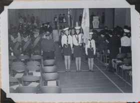
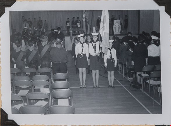
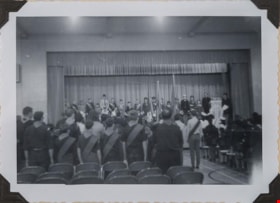
Baden Powell Sunday - honour guard
https://search.heritageburnaby.ca/link/museumdescription4964
- Repository
- Burnaby Village Museum
- Date
- Feb 22, 1970
- Collection/Fonds
- Burnaby Girl Guides fonds
- Description Level
- Item
- Physical Description
- 1 photograph : b&w ; 11.5 x 8 cm
- Scope and Content
- Photograph of the honour guard standing at attention during the "Baden Powell Sunday" event which took place at Burnaby South High School. Three Sea Rangers are dressed in uniforms with the one in the centre holding a Canadian Flag. Two members of the 51st Brownies are standing behind the Rangers a…
- Repository
- Burnaby Village Museum
- Collection/Fonds
- Burnaby Girl Guides fonds
- Description Level
- Item
- Physical Description
- 1 photograph : b&w ; 11.5 x 8 cm
- Scope and Content
- Photograph of the honour guard standing at attention during the "Baden Powell Sunday" event which took place at Burnaby South High School. Three Sea Rangers are dressed in uniforms with the one in the centre holding a Canadian Flag. Two members of the 51st Brownies are standing behind the Rangers and are holding the Guide flag.
- Geographic Access
- Southoaks Crescent
- Street Address
- 6650 Southoaks Crescent
- Accession Code
- BV016.49.106
- Access Restriction
- No restrictions
- Reproduction Restriction
- May be restricted by third party rights
- Date
- Feb 22, 1970
- Media Type
- Photograph
- Historic Neighbourhood
- Edmonds (Historic Neighbourhood)
- Planning Study Area
- Kingsway-Beresford Area
- Scan Resolution
- 600
- Scan Date
- 05/11/2018
- Scale
- 100
- Notes
- Title based on content of photograph
- Note in black ink next to photograph reads: "Back there are two / 51st Brownies as the / honour guard for the Guide flag"
- Photographs are part of scrapbook BV016.49.81
Images
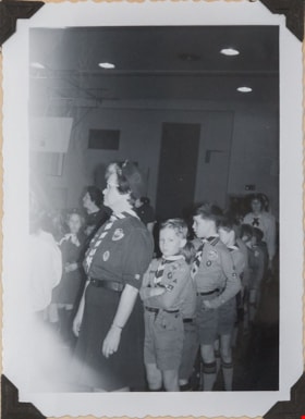
Badon Powell Sunday
https://search.heritageburnaby.ca/link/museumdescription4962
- Repository
- Burnaby Village Museum
- Date
- Feb 22, 1970
- Collection/Fonds
- Burnaby Girl Guides fonds
- Description Level
- Item
- Physical Description
- 1 photograph : b&w ; 11.5 x 8 cm
- Scope and Content
- Photograph of members of the 51st Burnaby Brownie Pack with Scouts, leaders and other guides for the "Baden Powell Sunday" event which took place at Burnaby South High School. The 51st Brownies are on the far left of the photograph.
- Repository
- Burnaby Village Museum
- Collection/Fonds
- Burnaby Girl Guides fonds
- Description Level
- Item
- Physical Description
- 1 photograph : b&w ; 11.5 x 8 cm
- Scope and Content
- Photograph of members of the 51st Burnaby Brownie Pack with Scouts, leaders and other guides for the "Baden Powell Sunday" event which took place at Burnaby South High School. The 51st Brownies are on the far left of the photograph.
- Geographic Access
- Southoaks Crescent
- Street Address
- 6650 Southoaks Crescent
- Accession Code
- BV016.49.104
- Access Restriction
- No restrictions
- Reproduction Restriction
- May be restricted by third party rights
- Date
- Feb 22, 1970
- Media Type
- Photograph
- Historic Neighbourhood
- Edmonds (Historic Neighbourhood)
- Planning Study Area
- Kingsway-Beresford Area
- Scan Resolution
- 600
- Scan Date
- 05/11/2018
- Notes
- Title based on content of photograph
- Note in black ink to the right of the photograph reads: "Badon - Powell Sunday" / "Feb. 22nd, 1970 / Burnaby South High / School". "Those are 51st Brownies / (on the far side)"
- Photograph is part of scrapbook BV016.49.81
Images
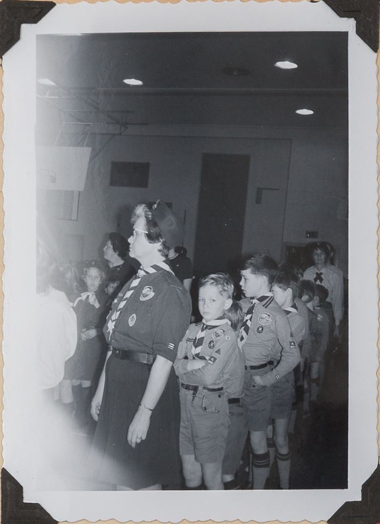
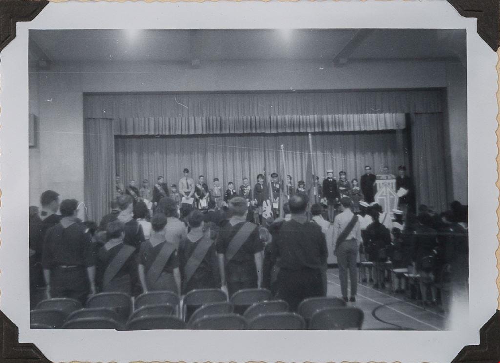
Badon Powell Sunday
https://search.heritageburnaby.ca/link/museumdescription4963
- Repository
- Burnaby Village Museum
- Date
- Feb 22, 1970
- Collection/Fonds
- Burnaby Girl Guides fonds
- Description Level
- Item
- Physical Description
- 1 photograph : b&w ; 11.5 x 8 cm
- Scope and Content
- Photograph of members of the 51st Burnaby Brownie Pack with Scouts, leaders and other guides for the "Baden Powell Sunday" event which took place at Burnaby South High School. Special guests are standing on the stage while the rest of the Girl Guides and Scouts look on from the audience. Father D. …
- Repository
- Burnaby Village Museum
- Collection/Fonds
- Burnaby Girl Guides fonds
- Description Level
- Item
- Physical Description
- 1 photograph : b&w ; 11.5 x 8 cm
- Scope and Content
- Photograph of members of the 51st Burnaby Brownie Pack with Scouts, leaders and other guides for the "Baden Powell Sunday" event which took place at Burnaby South High School. Special guests are standing on the stage while the rest of the Girl Guides and Scouts look on from the audience. Father D. Monroe was the officiating clergyman at the ceremony.
- Geographic Access
- Southoaks Crescent
- Street Address
- 6650 Southoaks Crescent
- Accession Code
- BV016.49.105
- Access Restriction
- No restrictions
- Reproduction Restriction
- May be restricted by third party rights
- Date
- Feb 22, 1970
- Media Type
- Photograph
- Historic Neighbourhood
- Edmonds (Historic Neighbourhood)
- Planning Study Area
- Kingsway-Beresford Area
- Scan Resolution
- 600
- Scan Date
- 05/11/2018
- Scale
- 100
- Notes
- Title based on content of photograph
- Note in black ink next to photograph reads: "Fr. D. Monroe was the / officiating clergyman"
- Photograph is part of scrapbook BV016.49.81
Images
![Burnaby South High School, [1925] thumbnail](/media/hpo/_Data/_BVM_Images/1972/1972_0200_0001_001.jpg?width=280)
Burnaby South High School
https://search.heritageburnaby.ca/link/museumdescription1106
- Repository
- Burnaby Village Museum
- Date
- [1925]
- Collection/Fonds
- Burnaby Village Museum Photograph collection
- Description Level
- Item
- Physical Description
- 1 photograph : b&w ; 17.7 x 12.7 cm
- Scope and Content
- Photograph of an unidentified class of teenaged girls and a female teacher. They are standing on the stairs or sitting on chairs laid out in front of the stairs to a double door to the school. The teacher is sitting on the right side of the photograph in the front row. All the girls have short hai…
- Repository
- Burnaby Village Museum
- Collection/Fonds
- Burnaby Village Museum Photograph collection
- Description Level
- Item
- Physical Description
- 1 photograph : b&w ; 17.7 x 12.7 cm
- Scope and Content
- Photograph of an unidentified class of teenaged girls and a female teacher. They are standing on the stairs or sitting on chairs laid out in front of the stairs to a double door to the school. The teacher is sitting on the right side of the photograph in the front row. All the girls have short hair, either parted and straight or bobbed. They are wearing loose fitting dresses with stockings. Some have scarves, ties and/or beads. The inscription and the signed gift form from the donor identify the photograph as a class at Burnaby South Highschool, from 1925. Inscribed on the negative and printed on the lower left of the photo: "#6." Annotated on the back of the photo: "1925 / B South." Stamped on the back of the photo: "Lloyd's Studio / 3966 Kingsway / McKay, B.C. Carl. 343R2."
- Subjects
- Occupations - Teachers
- Geographic Access
- Southoaks Crescent
- Street Address
- 6650 Southoaks Crescent
- Accession Code
- HV972.200.1
- Access Restriction
- No restrictions
- Reproduction Restriction
- May be restricted by third party rights
- Date
- [1925]
- Media Type
- Photograph
- Historic Neighbourhood
- Edmonds (Historic Neighbourhood)
- Planning Study Area
- Kingsway-Beresford Area
- Scan Resolution
- 600
- Scan Date
- 2023-04-18
- Photographer
- Lloyd, Frank Ernest
- Notes
- Title based on contents of photograph
Images
![Burnaby South High School, [1925] thumbnail](/media/hpo/_Data/_BVM_Images/1972/1972_0200_0001_001.jpg)
![Burnaby South High School, [1956] thumbnail](/media/Hpo/_Data/_BVM_Images/2016/2016_0046_0117_001.jpg?width=280)
Burnaby South High School
https://search.heritageburnaby.ca/link/museumdescription5162
- Repository
- Burnaby Village Museum
- Date
- [1956]
- Collection/Fonds
- Waplington family fonds
- Description Level
- Item
- Physical Description
- 1 photograph : b&w ; 12.7 x 18 cm
- Scope and Content
- Photograph a group of unidentifed students from Burnaby South High School. Photograph is taken at the front entrance of the school with the sign "Burnaby.South / High School" on the wall above the entrance way. Edith Louise Fleming graduated from Burnaby South High School in June 1956.
- Repository
- Burnaby Village Museum
- Collection/Fonds
- Waplington family fonds
- Description Level
- Item
- Physical Description
- 1 photograph : b&w ; 12.7 x 18 cm
- Scope and Content
- Photograph a group of unidentifed students from Burnaby South High School. Photograph is taken at the front entrance of the school with the sign "Burnaby.South / High School" on the wall above the entrance way. Edith Louise Fleming graduated from Burnaby South High School in June 1956.
- Geographic Access
- Southoaks Crescent
- Street Address
- 6650 Southoaks Crescent
- Accession Code
- BV016.46.117
- Access Restriction
- No restrictions
- Reproduction Restriction
- No known restrictions
- Date
- [1956]
- Media Type
- Photograph
- Historic Neighbourhood
- Edmonds (Historic Neighbourhood)
- Planning Study Area
- Kingsway-Beresford Area
- Scan Resolution
- 600
- Scan Date
- 13-Aug-2018
- Notes
- Title based on contents of photograph
- Note in blue ink on verso of photograph reads: "A "fun" photo - BBY SOUTH"
- Stamp on verso reads: "E.M. ALLEN LTD. / 2870 West Broadway / Vancouver 8, B.C."
- Photograph is part of Photograph album BV016.46.52
Images
![Burnaby South High School, [1956] thumbnail](/media/Hpo/_Data/_BVM_Images/2016/2016_0046_0117_001.jpg)
![Burnaby South High School students, [1941 or 1942] thumbnail](/media/Q:/51305%20BVM%20Collections/51305-05%20Acquisitions/_DigitalAssets/2005/2005_0035_0011_001.jpg?width=280)
Burnaby South High School students
https://search.heritageburnaby.ca/link/museumdescription1924
- Repository
- Burnaby Village Museum
- Date
- [1941 or 1942]
- Collection/Fonds
- Burnaby Village Museum Photograph collection
- Description Level
- Item
- Physical Description
- 1 photograph : b&w postcard ; 8 x 11.5 cm
- Scope and Content
- Photographic postcard of grade eight girls from Burnaby South High School sitting and standing in three rows in front of the school building. Sitting in the front row (from left) are; Sandra MacCarthy, Beatrice Dione, Gladys Richardson, Eunice Forster, Thelma Butler, Janice James, Edith Bryson and …
- Repository
- Burnaby Village Museum
- Collection/Fonds
- Burnaby Village Museum Photograph collection
- Description Level
- Item
- Physical Description
- 1 photograph : b&w postcard ; 8 x 11.5 cm
- Scope and Content
- Photographic postcard of grade eight girls from Burnaby South High School sitting and standing in three rows in front of the school building. Sitting in the front row (from left) are; Sandra MacCarthy, Beatrice Dione, Gladys Richardson, Eunice Forster, Thelma Butler, Janice James, Edith Bryson and Doris Peardon. Standing in the middle row are; Joan Ambridge, Rita Tory, Daphne Bradshaw, Jeanette Cruikshank, Bernice Kirk, Hannah Frith, Lorraine (last name unknown), Dorothy (last name unknown) and Betty Flatt. Standing in the back row are; Sheila Martin, Marion Mortimer, Ella Beatty, Marie Dean, Joanetta Messinger, Frances Spackman, Gloria Arnold, Rosanne Fraser, Flora Lawrie and Joan (last name unknown).
- Subjects
- Documentary Artifacts - Postcards
- Names
- Burnaby South High School
- MacCarthy, Sandra
- Dione, Beatrice
- Richardson, Gladys
- Forster, Eunice
- Butler, Thelma
- James, Janice
- Bryson, Edith
- Peardon, Doris
- Ambridge, Joan
- Tory, Rita
- Bradshaw, Daphne
- Cruickshank, Jeanette
- Kirk, Bernice
- Frith, Hannah
- Flat, Betty
- Martin, Sheila
- Mortimer, Marion
- Beatty, Ella
- Dean, Marie
- Messinger, Joanetta
- Spackman, Frances
- Arnold, Gloria
- Fraser, Rosanne
- Lawrie, Flora
- Geographic Access
- Southoaks Crescent
- Street Address
- 6650 Southoaks Crescent
- Accession Code
- BV005.35.11
- Access Restriction
- No restrictions
- Date
- [1941 or 1942]
- Media Type
- Photograph
- Historic Neighbourhood
- Edmonds (Historic Neighbourhood)
- Planning Study Area
- Kingsway-Beresford Area
- Scan Resolution
- 600
- Scan Date
- 11-Jun-09
- Scale
- 100
- Notes
- Title based on contents of photograph
- Photographer identifies photograph as no. 41
- Note in black ink on verso of photograph reads: "Grade 8 / Front Row Sandra McCarthy, Beatrice Dione, Gladys Richardson, Eunice Forester, Thelma Butler, Janice James, Edith Bryson, Doris Peardon Middle Row- Joan Ambridge, Rita Tory, Daphne Bradshaw Janette [sic] Cruikshank, Bernice Kirk, Hannah Frith Lorraine [illegible], Dorothy [illegible], Betty Flatt Back Row - Sheila Martin, Marion Mortimer, Ella Beatty Marie Dean, Joanetta Messinger, Frances Spackman, Gloria Arnold, Rosanne Fraser, Flora Lawrie, Joan [illegilbe]"
Images
![Burnaby South High School students, [1941 or 1942] thumbnail](/media/Q:/51305%20BVM%20Collections/51305-05%20Acquisitions/_DigitalAssets/2005/2005_0035_0011_001.jpg)
![Burnaby South High School students, [1942 or 1943] thumbnail](/media/Q:/51305%20BVM%20Collections/51305-05%20Acquisitions/_DigitalAssets/2005/2005_0035_0012_001.jpg?width=280)
Burnaby South High School students
https://search.heritageburnaby.ca/link/museumdescription1925
- Repository
- Burnaby Village Museum
- Date
- [1942 or 1943]
- Collection/Fonds
- Burnaby Village Museum Photograph collection
- Description Level
- Item
- Physical Description
- 1 photograph : b&w postcard ; 8 x 11.5 cm
- Scope and Content
- Photographic postcard of grade nine students from Burnaby South High School sitting and standing in three rows in front of the school building. Sitting in the front row (from left) are; Peter Adams, LeRoy Shaver, Harold Swan, Bob Schmid and Desmond Mayne. Sitting in the second row are; Jeanette Cru…
- Repository
- Burnaby Village Museum
- Collection/Fonds
- Burnaby Village Museum Photograph collection
- Description Level
- Item
- Physical Description
- 1 photograph : b&w postcard ; 8 x 11.5 cm
- Scope and Content
- Photographic postcard of grade nine students from Burnaby South High School sitting and standing in three rows in front of the school building. Sitting in the front row (from left) are; Peter Adams, LeRoy Shaver, Harold Swan, Bob Schmid and Desmond Mayne. Sitting in the second row are; Jeanette Cruickshank, Thelma Butler, Janice James, Edith Bryson, Hannah Frith, Kay Graves, Eunice Forster, Rita Tory, Betty McLachlan and Sandra MacCarthy. Standing in the third row are; Elsie Williamson, Stella Maruk, Aleda Wadham, Gladys Judge, Marion Mortimer, Lois Winters, Joan Adlem, Doris Peardon, Eleanor Thomson and Ella Beatty. Standing in the back row are; Dale Bonnycastle, Pat (last name unknown), Betty Robertson, Dorothy Kool, Frances Spackman, Helen Obrastroff, Flora Lawrie, Mary Lou Neeley, Gloria Arnold, Rodney Cairns and George Vipond.
- Subjects
- Documentary Artifacts - Postcards
- Names
- Burnaby South High School
- Adams, Peter
- Shaver, LeRoy
- Swan, Harold
- Schmid, Bob
- Mayne, Desmond
- Cruickshank, Jeanette
- Butler, Thelma
- James, Janice
- Bryson, Edith
- Frith, Hannah
- Graves, Kay
- Forster, Eunice
- Tory, Rita
- McLachlan, Betty
- MacCarthy, Sandra
- Williamson, Elsie
- Maruk, Stella
- Wadham, Aleda
- Judge, Gladys
- Mortimer, Marion
- Winters, Lois
- Adlem, Joan
- Peardon, Doris
- Thompson, Elleanor
- Beatty, Ella
- Bonnycastle, Dale
- Robertson, Betty
- Kool, Dorothy
- Spackman, Frances
- Obrastroff, Helen
- Lawrie, Flora
- Neeley, Mary Lou
- Arnold, Gloria
- Cairns, Rodney
- Vipond, George
- Geographic Access
- Southoaks Crescent
- Street Address
- 6650 Southoaks Crescent
- Accession Code
- BV005.35.12
- Access Restriction
- No restrictions
- Date
- [1942 or 1943]
- Media Type
- Photograph
- Historic Neighbourhood
- Edmonds (Historic Neighbourhood)
- Planning Study Area
- Kingsway-Beresford Area
- Scan Resolution
- 600
- Scan Date
- 11-Jun-09
- Scale
- 100
- Notes
- Title based on contents of photograph
- Students have written their autographs on verso of photograph
Images
![Burnaby South High School students, [1942 or 1943] thumbnail](/media/Q:/51305%20BVM%20Collections/51305-05%20Acquisitions/_DigitalAssets/2005/2005_0035_0012_001.jpg)
![Burnaby South High School students, [1945] thumbnail](/media/Q:/51305%20BVM%20Collections/51305-05%20Acquisitions/_DigitalAssets/2005/2005_0035_0014_001.jpg?width=280)
Burnaby South High School students
https://search.heritageburnaby.ca/link/museumdescription1927
- Repository
- Burnaby Village Museum
- Date
- [1945]
- Collection/Fonds
- Burnaby Village Museum Photograph collection
- Description Level
- Item
- Physical Description
- 1 photograph : sepia ; 11.5 x 16.5 cm
- Scope and Content
- Photograph of grade eleven (or twelve) students from Burnaby South High School sitting and standing in four rows in front of the school building with their teacher, Mr. Lyons. Sitting in the front row (from left) are; Doreen Reagh, unidentified, Mr. Lyons, Joyce Parker, Lois Winters and Betty Smith…
- Repository
- Burnaby Village Museum
- Collection/Fonds
- Burnaby Village Museum Photograph collection
- Description Level
- Item
- Physical Description
- 1 photograph : sepia ; 11.5 x 16.5 cm
- Scope and Content
- Photograph of grade eleven (or twelve) students from Burnaby South High School sitting and standing in four rows in front of the school building with their teacher, Mr. Lyons. Sitting in the front row (from left) are; Doreen Reagh, unidentified, Mr. Lyons, Joyce Parker, Lois Winters and Betty Smith. Standing in the second row are; Eunice Forster, Jacqueline Winters, Elleanor Thompson, Morice Mallory, Ken West, Clint LaCroix, Jacqueline Pope, Ella Beatty and Edith Bryson. Standing in the last row are; Norman McKenzie, Bill Shears, Reginald Shrimpton, Barry Bighorn, Jack Casey, Dave Major and Morton Thorsell.
- Subjects
- Occupations - Teachers
- Names
- Burnaby South High School
- Reagh, Doreen
- Lyons, Mr.
- Parker, Joyce
- Winters, Lois
- Smith, Betty
- Forster, Eunice
- Winters, Jacqueline
- Thompson, Elleanor
- Mallory, Maurice
- West, Ken
- La Croix, Clint
- Pope, Jacqueline
- Beatty, Ella
- Bryson, Edith
- McKenzie, Norman
- Shears, Bill
- Shrimpton, Reginald
- Bighorn, Barry
- Casey, Jack
- Major, Dave
- Thorsell, Morton
- Geographic Access
- Southoaks Crescent
- Street Address
- 6650 Southoaks Crescent
- Accession Code
- BV005.35.14
- Access Restriction
- No restrictions
- Date
- [1945]
- Media Type
- Photograph
- Historic Neighbourhood
- Edmonds (Historic Neighbourhood)
- Planning Study Area
- Kingsway-Beresford Area
- Scan Resolution
- 600
- Scan Date
- 11-Jun-09
- Scale
- 100
- Notes
- Title based on contents of photograph
- Notes on verso of photograph read: "Grade # 11 ?/ Front Row Doreen Reagh, ? ? , Mr. Lyons, Joyce Parker Lois Winters, Betty Smith./ Second Row Eunice Forester [sic], Jacqueline Winters, Eleanor Thompson, Morice Mallory Ken West, Clint LaCroix, Jacqueline Pope, Ella Beatty, Edith Bryson/ Third Row Norman McKenzie, Bill Shears, Reginald Shrimpton, Barry Bighorn, Jack Casey Dave Major, Morton Thorsell"
Images
![Burnaby South High School students, [1945] thumbnail](/media/Q:/51305%20BVM%20Collections/51305-05%20Acquisitions/_DigitalAssets/2005/2005_0035_0014_001.jpg)