Narrow Results By
Subject
- Adornment 1
- Adornment - Lapel Pins 1
- Advertising Medium 7
- Advertising Medium - Business Cards 2
- Advertising Medium - Flyer 15
- Advertising Medium - Poster 3
- Advertising Medium - Signs and Signboards
- Aerial Photographs 1
- Agriculture 4
- Agriculture - Crops 1
- Agriculture - Farms 9
- Agriculture - Fruit and Berries 2

Admiral Hotel
https://search.heritageburnaby.ca/link/archivedescription93660
- Repository
- City of Burnaby Archives
- Date
- November 13, 1977
- Collection/Fonds
- Burnaby Public Library Contemporary Visual Archive Project
- Description Level
- Item
- Physical Description
- 1 photograph : b&w ; 12.5 x 17.5 cm
- Scope and Content
- Photograph of the front exterior of the Admiral Hotel, located on the 4100 block of Hastings Street. The photograph is taken from across the street, facing northwest, and shows the mural on the front of the hotel and the hotel's sign.
- Repository
- City of Burnaby Archives
- Date
- November 13, 1977
- Collection/Fonds
- Burnaby Public Library Contemporary Visual Archive Project
- Physical Description
- 1 photograph : b&w ; 12.5 x 17.5 cm
- Description Level
- Item
- Record No.
- 556-617
- Access Restriction
- No restrictions
- Reproduction Restriction
- Reproduce for fair dealing purposes only
- Accession Number
- 2017-57
- Scope and Content
- Photograph of the front exterior of the Admiral Hotel, located on the 4100 block of Hastings Street. The photograph is taken from across the street, facing northwest, and shows the mural on the front of the hotel and the hotel's sign.
- Names
- Admiral Hotel
- Media Type
- Photograph
- Photographer
- Chapman, Fred
- Notes
- Title taken from project information form
- Accompanied by a project information form and 1 photograph (b&w negative ; 9.5 x 12.5 cm)
- BPL no. 67
- Geographic Access
- Hastings Street
- Street Address
- 4125 Hastings Street
- Historic Neighbourhood
- Vancouver Heights (Historic Neighbourhood)
- Planning Study Area
- Burnaby Heights Area
Images


Astor Hotel
https://search.heritageburnaby.ca/link/archivedescription93657
- Repository
- City of Burnaby Archives
- Date
- November 13, 1977
- Collection/Fonds
- Burnaby Public Library Contemporary Visual Archive Project
- Description Level
- Item
- Physical Description
- 1 photograph : b&w ; 12.5 x 17.5 cm
- Scope and Content
- Photograph of the exterior of the Astor Motor Hotel and its hotel sign, located on the 4500 block of Kingsway. The photograph is taken facing northeast.
- Repository
- City of Burnaby Archives
- Date
- November 13, 1977
- Collection/Fonds
- Burnaby Public Library Contemporary Visual Archive Project
- Physical Description
- 1 photograph : b&w ; 12.5 x 17.5 cm
- Description Level
- Item
- Record No.
- 556-614
- Access Restriction
- No restrictions
- Reproduction Restriction
- Reproduce for fair dealing purposes only
- Accession Number
- 2017-57
- Scope and Content
- Photograph of the exterior of the Astor Motor Hotel and its hotel sign, located on the 4500 block of Kingsway. The photograph is taken facing northeast.
- Names
- Astor Hotel
- Media Type
- Photograph
- Photographer
- Chapman, Fred
- Notes
- Title taken from project information form
- Accompanied by a project information form and 1 photograph (b&w negative ; 9.5 x 12.5 cm)
- BPL no. 64
- Geographic Access
- Kingsway
- Street Address
- 4561 Kingsway
- Historic Neighbourhood
- Central Park (Historic Neighbourhood)
- Planning Study Area
- Marlborough Area
Images


Crossing Royal Oak & Rumble Street
https://search.heritageburnaby.ca/link/archivedescription93686
- Repository
- City of Burnaby Archives
- Date
- May 19, 1978
- Collection/Fonds
- Burnaby Public Library Contemporary Visual Archive Project
- Description Level
- Item
- Physical Description
- 1 photograph : b&w ; 12.5 x 17.5 cm
- Scope and Content
- Photograph of the intersection of Royal Oak Avenue and Rumble Street. Cars and pedestrians are crossing the intersection, and the signs for businesses TD Bank, Standard Oil/Chevron gas station, Gulf gas station, and Baxter's Market are visible. The photograph is taken from a corner of the intersect…
- Repository
- City of Burnaby Archives
- Date
- May 19, 1978
- Collection/Fonds
- Burnaby Public Library Contemporary Visual Archive Project
- Physical Description
- 1 photograph : b&w ; 12.5 x 17.5 cm
- Description Level
- Item
- Record No.
- 556-643
- Access Restriction
- No restrictions
- Reproduction Restriction
- Reproduce for fair dealing purposes only
- Accession Number
- 2017-57
- Scope and Content
- Photograph of the intersection of Royal Oak Avenue and Rumble Street. Cars and pedestrians are crossing the intersection, and the signs for businesses TD Bank, Standard Oil/Chevron gas station, Gulf gas station, and Baxter's Market are visible. The photograph is taken from a corner of the intersection, facing southeast.
- Subjects
- Geographic Features - Roads
- Advertising Medium - Signs and Signboards
- Buildings - Commercial - Service Stations
- Transportation - Automobiles
- Buildings - Commercial
- Media Type
- Photograph
- Photographer
- van Mannen, Mark
- Notes
- Title taken from project information form
- Accompanied by a project information form and 1 photograph (b&w negative ; 9.5 x 12.5 cm)
- BPL no. 91
- Geographic Access
- Royal Oak Avenue
- Rumble Street
- Historic Neighbourhood
- Alta Vista (Historic Neighbourhood)
- Planning Study Area
- Sussex-Nelson Area
Images


Crossing Royal Oak & Rumble Street
https://search.heritageburnaby.ca/link/archivedescription93687
- Repository
- City of Burnaby Archives
- Date
- May 19, 1978
- Collection/Fonds
- Burnaby Public Library Contemporary Visual Archive Project
- Description Level
- Item
- Physical Description
- 1 photograph : b&w ; 12.5 x 17.5 cm
- Scope and Content
- Photograph of the intersection of Royal Oak Avenue and Rumble Street. Cars and pedestrians are crossing the intersection, and the signs for businesses Grace United Pharmacy, Standard Oil/Chevron gas station, Gulf gas station, and Royal Meats are visible. The photograph is taken from the Gulf gas st…
- Repository
- City of Burnaby Archives
- Date
- May 19, 1978
- Collection/Fonds
- Burnaby Public Library Contemporary Visual Archive Project
- Physical Description
- 1 photograph : b&w ; 12.5 x 17.5 cm
- Description Level
- Item
- Record No.
- 556-644
- Access Restriction
- No restrictions
- Reproduction Restriction
- Reproduce for fair dealing purposes only
- Accession Number
- 2017-57
- Scope and Content
- Photograph of the intersection of Royal Oak Avenue and Rumble Street. Cars and pedestrians are crossing the intersection, and the signs for businesses Grace United Pharmacy, Standard Oil/Chevron gas station, Gulf gas station, and Royal Meats are visible. The photograph is taken from the Gulf gas station parking lot, facing northwest.
- Subjects
- Advertising Medium - Signs and Signboards
- Geographic Features - Roads
- Transportation - Automobiles
- Buildings - Commercial
- Buildings - Commercial - Service Stations
- Media Type
- Photograph
- Photographer
- van Mannen, Mark
- Notes
- Title taken from project information form
- Accompanied by a project information form and 1 photograph (b&w negative ; 9.5 x 12.5 cm)
- BPL no. 92
- Geographic Access
- Royal Oak Avenue
- Rumble Street
- Historic Neighbourhood
- Alta Vista (Historic Neighbourhood)
- Planning Study Area
- Sussex-Nelson Area
Images


Hallett's Eggs
https://search.heritageburnaby.ca/link/archivedescription93656
- Repository
- City of Burnaby Archives
- Date
- November 13, 1977
- Collection/Fonds
- Burnaby Public Library Contemporary Visual Archive Project
- Description Level
- Item
- Physical Description
- 1 photograph : b&w ; 12.5 x 17.5 cm
- Scope and Content
- Photograph of a house surrounded by trees at 6947 Hastings Street. There is a sign in front of the home advertising "Hallett's Eggs & Poultry" and a "For Sale" sign. The photograph is taken from across the street, facing northeast.
- Repository
- City of Burnaby Archives
- Date
- November 13, 1977
- Collection/Fonds
- Burnaby Public Library Contemporary Visual Archive Project
- Physical Description
- 1 photograph : b&w ; 12.5 x 17.5 cm
- Description Level
- Item
- Record No.
- 556-613
- Access Restriction
- No restrictions
- Reproduction Restriction
- Reproduce for fair dealing purposes only
- Accession Number
- 2017-57
- Scope and Content
- Photograph of a house surrounded by trees at 6947 Hastings Street. There is a sign in front of the home advertising "Hallett's Eggs & Poultry" and a "For Sale" sign. The photograph is taken from across the street, facing northeast.
- Subjects
- Agriculture - Poultry
- Buildings - Commercial - Grocery Stores
- Advertising Medium - Signs and Signboards
- Media Type
- Photograph
- Photographer
- Chapman, Fred
- Notes
- Title taken from project information form
- Accompanied by a project information form and 1 photograph (b&w negative ; 9.5 x 12.5 cm)
- BPL no. 63
- Geographic Access
- Hastings Street
- Street Address
- 6947 Hastings Street
- Historic Neighbourhood
- Lochdale (Historic Neighbourhood)
- Planning Study Area
- Westridge Area
Images


Joey Restaurant
https://search.heritageburnaby.ca/link/archivedescription95118
- Repository
- City of Burnaby Archives
- Date
- April 1, 2020
- Collection/Fonds
- Burnaby Photographic Society fonds
- Description Level
- Item
- Physical Description
- 1 photograph (tiff)
- Scope and Content
- Photograph of a sign perched on a decorative tree trunk in the foyer of Joey Burnaby. The sign contains information for patrons on food delivery and pickup.
- Repository
- City of Burnaby Archives
- Date
- April 1, 2020
- Collection/Fonds
- Burnaby Photographic Society fonds
- Physical Description
- 1 photograph (tiff)
- Description Level
- Item
- Record No.
- 623-036
- Access Restriction
- No restrictions
- Reproduction Restriction
- No restrictions
- Accession Number
- 2020-10
- Scope and Content
- Photograph of a sign perched on a decorative tree trunk in the foyer of Joey Burnaby. The sign contains information for patrons on food delivery and pickup.
- Media Type
- Photograph
- Photographer
- Cheung, Ray
- Notes
- Transcribed title
- Photographer's caption: "Most restaurants were only open for take-away"
- Geographic Access
- Rosser Avenue
- Street Address
- 1901 Rosser Avenue
- Planning Study Area
- Willingdon Heights Area
Images


Lougheed Hotel
https://search.heritageburnaby.ca/link/archivedescription93625
- Repository
- City of Burnaby Archives
- Date
- October 23, 1977
- Collection/Fonds
- Burnaby Public Library Contemporary Visual Archive Project
- Description Level
- Item
- Physical Description
- 1 photograph : b&w ; 12.5 x 17.5 cm
- Scope and Content
- Photograph of the Lougheed Hotel on Lougheed Highway near Willingdon Avenue. The photograph is taken facing west and shows the hotel's sign, parking lot, and main hotel building.
- Repository
- City of Burnaby Archives
- Date
- October 23, 1977
- Collection/Fonds
- Burnaby Public Library Contemporary Visual Archive Project
- Physical Description
- 1 photograph : b&w ; 12.5 x 17.5 cm
- Description Level
- Item
- Record No.
- 556-582
- Access Restriction
- No restrictions
- Reproduction Restriction
- Reproduce for fair dealing purposes only
- Accession Number
- 2017-57
- Scope and Content
- Photograph of the Lougheed Hotel on Lougheed Highway near Willingdon Avenue. The photograph is taken facing west and shows the hotel's sign, parking lot, and main hotel building.
- Names
- Lougheed Hotel
- Media Type
- Photograph
- Photographer
- Surridge, Jack
- Notes
- Title taken from project information form
- Accompanied by a project information form and 1 photograph (b&w negative ; 9.5 x 12.5 cm)
- BPL no. 29
- Street Address
- 4343 Lougheed Highway
- Historic Neighbourhood
- Vancouver Heights (Historic Neighbourhood)
- Planning Study Area
- Willingdon Heights Area
Images


Old Orchard Shopping Centre
https://search.heritageburnaby.ca/link/archivedescription93603
- Repository
- City of Burnaby Archives
- Date
- October 9, 1977
- Collection/Fonds
- Burnaby Public Library Contemporary Visual Archive Project
- Description Level
- Item
- Physical Description
- 1 photograph : b&w ; 12.5 x 17.5 cm
- Scope and Content
- Photograph of the Old Orchard Shopping Centre, located at Kingsway and Willingdon. The photograph is taken from across the road, facing northwest, and focuses on the shopping centre sign. The other stores' signs, including Shoppers Drug Mart and Autoplan, and a high-rise apartment building are visi…
- Repository
- City of Burnaby Archives
- Date
- October 9, 1977
- Collection/Fonds
- Burnaby Public Library Contemporary Visual Archive Project
- Physical Description
- 1 photograph : b&w ; 12.5 x 17.5 cm
- Description Level
- Item
- Record No.
- 556-560
- Access Restriction
- No restrictions
- Reproduction Restriction
- Reproduce for fair dealing purposes only
- Accession Number
- 2017-57
- Scope and Content
- Photograph of the Old Orchard Shopping Centre, located at Kingsway and Willingdon. The photograph is taken from across the road, facing northwest, and focuses on the shopping centre sign. The other stores' signs, including Shoppers Drug Mart and Autoplan, and a high-rise apartment building are visible in the background.
- Subjects
- Buildings - Commercial - Malls
- Advertising Medium - Signs and Signboards
- Buildings - Residential - Apartments
- Media Type
- Photograph
- Photographer
- Chapman, Fred
- Notes
- Title taken from project information form
- Accompanied by a project information form and 1 photograph (b&w negative ; 9.5 x 12.5 cm)
- BPL no. 4
- Geographic Access
- Kingsway
- Street Address
- 4469 Kingsway
- Historic Neighbourhood
- Central Park (Historic Neighbourhood)
- Planning Study Area
- Maywood Area
Images


One person per household
https://search.heritageburnaby.ca/link/archivedescription95109
- Repository
- City of Burnaby Archives
- Date
- April 27, 2020
- Collection/Fonds
- Burnaby Photographic Society fonds
- Description Level
- Item
- Physical Description
- 1 photograph (tiff)
- Scope and Content
- Photograph of the entrance at Save-On-Foods grocery store. One of the two doors at the entrance is blocked by a freestanding sign that reads: "To prevent the spread of COVID-19 Limit 1 person per household". Next to the sign is a shopping cart with signage attached to it informing shoppers that r…
- Repository
- City of Burnaby Archives
- Date
- April 27, 2020
- Collection/Fonds
- Burnaby Photographic Society fonds
- Physical Description
- 1 photograph (tiff)
- Description Level
- Item
- Record No.
- 623-027
- Access Restriction
- No restrictions
- Reproduction Restriction
- No restrictions
- Accession Number
- 2020-10
- Scope and Content
- Photograph of the entrance at Save-On-Foods grocery store. One of the two doors at the entrance is blocked by a freestanding sign that reads: "To prevent the spread of COVID-19 Limit 1 person per household". Next to the sign is a shopping cart with signage attached to it informing shoppers that reusable and cloth bags are prohibited in the store.
- Media Type
- Photograph
- Photographer
- Snowdon, Nick
- Notes
- Transcribed title
- Photographer's caption: "Early on in the pandemic, stores limit number of people from one household. This does not last very long."
- Geographic Access
- Kingsway
- Street Address
- 4429 Kingsway
- Historic Neighbourhood
- Central Park (Historic Neighbourhood)
- Planning Study Area
- Garden Village Area
Images


Royal Oak Plaza
https://search.heritageburnaby.ca/link/archivedescription93605
- Repository
- City of Burnaby Archives
- Date
- October 9, 1977
- Collection/Fonds
- Burnaby Public Library Contemporary Visual Archive Project
- Description Level
- Item
- Physical Description
- 1 photograph : b&w ; 12.5 x 17.5 cm
- Scope and Content
- Photograph of Royal Oak Plaza's parking lot and sign, located at Royal Oak and Rumble Street. The photograph is taken facing north. A Safeway is visible in the background.
- Repository
- City of Burnaby Archives
- Date
- October 9, 1977
- Collection/Fonds
- Burnaby Public Library Contemporary Visual Archive Project
- Physical Description
- 1 photograph : b&w ; 12.5 x 17.5 cm
- Description Level
- Item
- Record No.
- 556-562
- Access Restriction
- No restrictions
- Reproduction Restriction
- Reproduce for fair dealing purposes only
- Accession Number
- 2017-57
- Scope and Content
- Photograph of Royal Oak Plaza's parking lot and sign, located at Royal Oak and Rumble Street. The photograph is taken facing north. A Safeway is visible in the background.
- Subjects
- Advertising Medium - Signs and Signboards
- Buildings - Commercial - Grocery Stores
- Buildings - Commercial - Malls
- Media Type
- Photograph
- Photographer
- Chapman, Fred
- Notes
- Title taken from project information form
- Accompanied by a project information form and 1 photograph (b&w negative ; 9.5 x 12.5 cm)
- BPL no. 6
- Geographic Access
- Royal Oak Avenue
- Rumble Street
- Historic Neighbourhood
- Central Park (Historic Neighbourhood)
- Planning Study Area
- Clinton-Glenwood Area
Images

sign
https://search.heritageburnaby.ca/link/museumartifact91627
- Repository
- Burnaby Village Museum
- Accession Code
- BV022.21.101
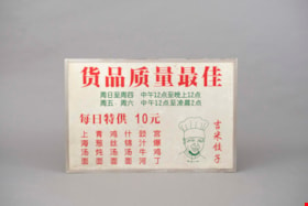
- Description
- Sign designed to look like a menu board for a movie prop. The board is printed on an aluminum frame dry erase board.
- The front of the board is white and has Chinese characters printed in red and green text with an illustration of a person in a chef's hat on the right side.
- The english translation is provided on the back of the board in the technical specifications.
- The technical specifications on the back include information about the scale, text colours, and movie information like director, production design, set number.
- Object History
- "Jimmy's Dumplings" prop created as part of a street scene in movie Fantastic Four 2.
- Jimmy Chow worked in TV and film as a property master for more than 42 years. A property master is responsible for building and procuring props that actors handle and use. This sometimes means making replica items that are lighter, false or make filming easier on the actor. This differs from set decoration, which uses props to create a backdrop and is less central to the action on set.
- Jimmy Chow was responsible for designing, managing, and sourcing props for films such as: BFG, Warcraft: The Beginning, X-Men 2, Fantastic Four, Watchman, Tron: Legacy, Little Women, Seven Years in Tibet, Shanghai Noon, The Shipping News, Fantastic Four: Rise of the Silver Surfer, The Changeling, Man of Steel (Superman), Snow Falling on Cedars, Legends of the Fall, And the Sea Will Tell, and Once a Thief.
- He entered the film industry in 1973 working for CBC Vancouver and gained valuable experience working on the set of the television series The Beachcombers, which launched his career.
- Category
- 08. Communication Artifacts
- Classification
- Advertising Media
- Object Term
- Sign, Advertising
- Marks/Labels
- English Translation: Best Selection / Sun-Thurs 12pm-12am / Fri-Sat 12pm-2am / Daily Specials From 10 Yuan / Shanghai Noodle Soup / Green Onion with Braised Noodles / Souple Noodles with Shredded Chicken / Fried Rice Noodles with Beef / Diced Chicken with Sauce / Jimmy Dumpling
- Names
- Chow, Hipman "Jimmy"
Images

sign
https://search.heritageburnaby.ca/link/museumartifact91783
- Repository
- Burnaby Village Museum
- Accession Code
- BV023.17.3
- Description
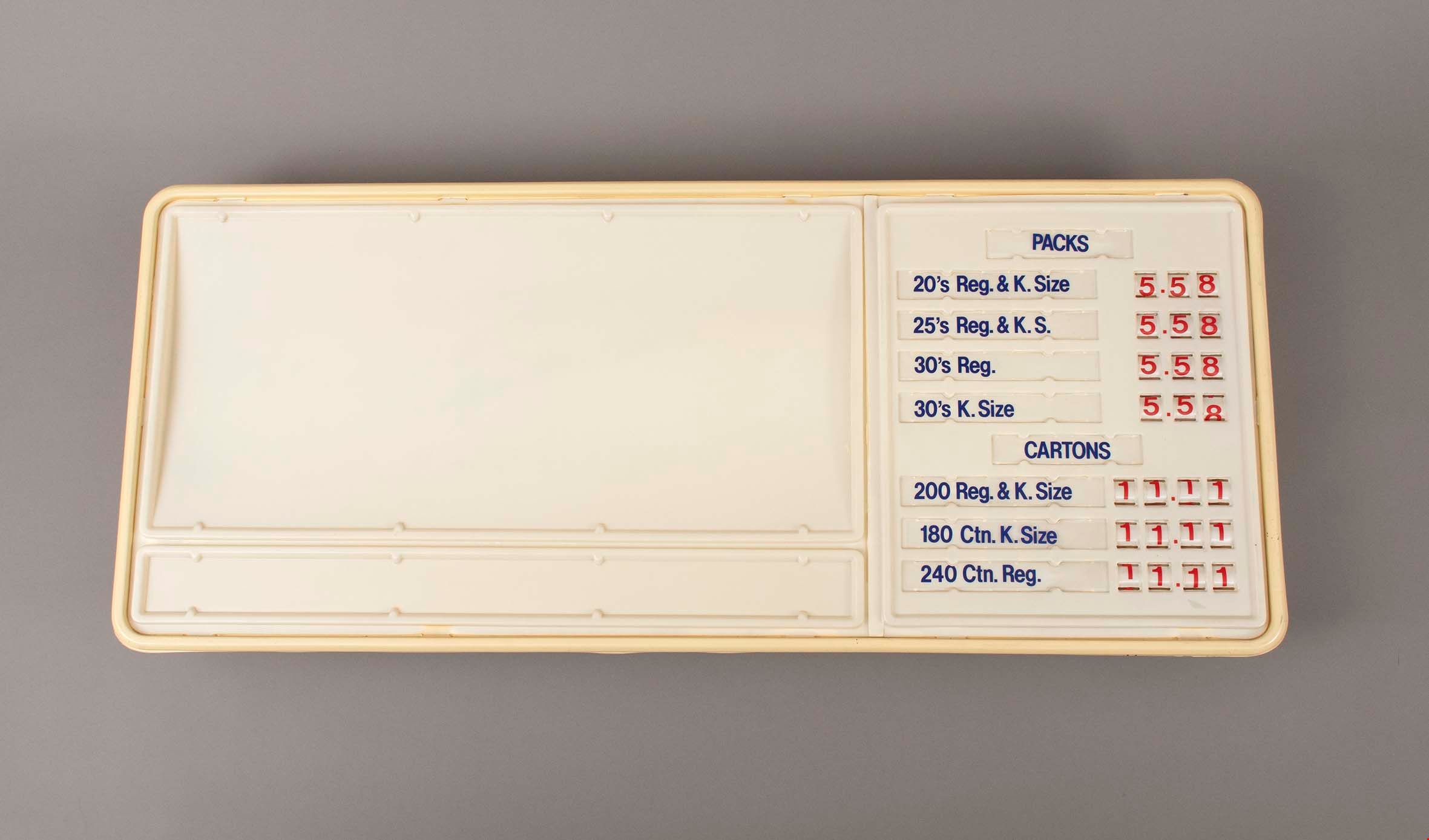
- Large plastic sign with internal backlighting for advertising. The sign has two sections for ad inserts and one section for price display.
- The price display is currently set up advertising the price of packs and cartons of cigarettes
- The first bank of prices are 3 digit with small windows that reveal the number on a roller behind. The second bank of prices are 4 digits.
- The sign was made by CDA Industries in Scarborough, Ontario and is stamped with "JULY 1986"
- There are three labels at the top of the sign including information about how to replace the lamps or reinsert unrolled numbers.
- There is a hole at the top of the sign for the electrical cord to come out.
- There are two white metal brackets attached to the ends of the sign and there is a rusted chain hanging from each bracket.
- The plastic at the bottom right corner on the back is broken and damaged.
- Object History
- Item was used in the Canada Way Food Market owned by Harry Toy between 1975 and the late 2000s. the building sat vacant until sold in 2023.
- See BV023.25.1 for photograph of sign in situ.
- Category
- 08. Communication Artifacts
- Classification
- Advertising Media
- Object Term
- Sign, Advertising
- Marks/Labels
- "PACKS / 20's Reg. & K. Size 5.58 / 25's Reg. & K.S. 5.58 / 30's Reg. 5.58 / 30's K. Size 5.58"
- "CARTONS / 200 Reg. & K.Size 11.11 / 180 Ctn. K. Size 11.11 / 240 Ctn. Reg. 11.11"
- Measurements
- Height: 57.5 cm
- Width: 133.5 cm
- Depth: 13 cm
- Names
- Canada Way Food Market
- Geographic Access
- Canada Way
- Street Address
- 4692 Canada Way
Images
sign
https://search.heritageburnaby.ca/link/museumartifact91784
- Repository
- Burnaby Village Museum
- Accession Code
- BV023.17.4
- Description
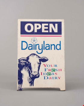
- Wooden sandwich board advertising Dairyland products. The board consists of two wooden panels that were attached at the top with a piano hinge. The hinge is currently only attached to one panel. The wooden panels are painted white. The paint is chipping in many areas.
- Both panels feature the same information and have an large illustration of a cow's head an front body on the bottom left.
- The two panels are held together on the back with a rusty metal chain.
- Handwritten on the back of one of the panels is "Canada Way Food Market"
- Object History
- Item was used in the Canada Way Food Market owned by Harry Toy between 1975 and the late 2000s. the building sat vacant until sold in 2023.
- Category
- 08. Communication Artifacts
- Classification
- Advertising Media
- Object Term
- Sign, Advertising
- Marks/Labels
- "OPEN / Dairyland / Your / Fresh / Ideas / Dairy"
- Measurements
- Height: 74.5 cm
- Width: 49 cm
- Names
- Canada Way Food Market
- Geographic Access
- Canada Way
- Street Address
- 4692 Canada Way
Images


Sussex Villa with sign
https://search.heritageburnaby.ca/link/archivedescription98660
- Repository
- City of Burnaby Archives
- Date
- 2022
- Collection/Fonds
- Disappearing Burnaby collection
- Description Level
- Item
- Physical Description
- 1 photograph (jpeg) : col.
- Scope and Content
- Photograph of part of the exterior and front lawn of Sussex Villa, an apartment complex located at 6620-6630 Sussex Avenue, at night. The building was constructed in 1965 and is set to be developed into a high-rise tower by Keltic Canada Development. A sign standing on the lawn reads: "Land Loan" a…
- Repository
- City of Burnaby Archives
- Date
- 2022
- Collection/Fonds
- Disappearing Burnaby collection
- Physical Description
- 1 photograph (jpeg) : col.
- Description Level
- Item
- Record No.
- 634-007
- Access Restriction
- No restrictions
- Reproduction Restriction
- No restrictions
- Accession Number
- 2022-14
- Scope and Content
- Photograph of part of the exterior and front lawn of Sussex Villa, an apartment complex located at 6620-6630 Sussex Avenue, at night. The building was constructed in 1965 and is set to be developed into a high-rise tower by Keltic Canada Development. A sign standing on the lawn reads: "Land Loan" and "Domain Funding" with contact information, and a residential tower is visible in the background.
- Subjects
- Buildings - Residential - Apartments
- Buildings - Residential
- Advertising Medium - Signs and Signboards
- Media Type
- Photograph
- Photographer
- Cheung, Nakita
- Notes
- Title taken from the associated blog post
- Associated blog post: https://disappearingburnaby.wordpress.com/2022/01/29/sussex-villa-2/
- Geographic Access
- Sussex Avenue
- Street Address
- 6620 Sussex Avenue
- 6630 Sussex Avenue
- Historic Neighbourhood
- Central Park (Historic Neighbourhood)
- Planning Study Area
- Maywood Area
Images
