Narrow Results By
![Sidney Roofing and Paper Company, [1960] thumbnail](/media/Hpo/_Data/_Archives_Images/_Unrestricted/001/091-001.jpg?width=280)
Sidney Roofing and Paper Company
https://search.heritageburnaby.ca/link/archivedescription34676
- Repository
- City of Burnaby Archives
- Date
- [1960]
- Collection/Fonds
- Burnaby Historical Society fonds
- Description Level
- Item
- Physical Description
- 1 photograph : b&w ; 20.2 x 25.7 cm mounted on cardboard
- Scope and Content
- Aerial photograph of Sidney Roofing and Paper Company located in South Burnaby.
- Repository
- City of Burnaby Archives
- Date
- [1960]
- Collection/Fonds
- Burnaby Historical Society fonds
- Subseries
- Photographs subseries
- Physical Description
- 1 photograph : b&w ; 20.2 x 25.7 cm mounted on cardboard
- Description Level
- Item
- Record No.
- 091-001
- Access Restriction
- No restrictions
- Reproduction Restriction
- Reproduce for fair dealing purposes only
- Accession Number
- BHS2007-04
- Scope and Content
- Aerial photograph of Sidney Roofing and Paper Company located in South Burnaby.
- Subjects
- Aerial Photographs
- Buildings - Industrial
- Media Type
- Photograph
- Photographer
- Graphic Industries Limited
- Notes
- Title based on contents of photograph
- Bottom of photo has the "Sidney Products" logo and reads, "Sidney Roofing & Paper Co. Ltd."
- Printed on back of cardboard "GIL: Graphic Industries Ltd. / Vancouver's Largest Commercial Photographers / 1201 Melville St., Vancouver 1, B.C. / Phone MUtual 1-4174 File No: 4601 3"
- Annotation on back of photograph reads, "[illegible of Sid R. in Burnaby looking N/W / June 5 '58"
- Historic Neighbourhood
- Fraser Arm (Historic Neighbourhood)
- Planning Study Area
- Big Bend Area
Images
![Sidney Roofing and Paper Company, [1960] thumbnail](/media/Hpo/_Data/_Archives_Images/_Unrestricted/001/091-001.jpg)
![Sidney Roofing and Paper Company, [1960] thumbnail](/media/Hpo/_Data/_Archives_Images/_Unrestricted/001/091-004.jpg?width=280)
Sidney Roofing and Paper Company
https://search.heritageburnaby.ca/link/archivedescription34679
- Repository
- City of Burnaby Archives
- Date
- [1960]
- Collection/Fonds
- Burnaby Historical Society fonds
- Description Level
- Item
- Physical Description
- 1 photograph : b&w ; 20.5 x 25.3 cm
- Scope and Content
- Aerial photograph of Sidney Roofing and Paper Company, South Burnaby.
- Repository
- City of Burnaby Archives
- Date
- [1960]
- Collection/Fonds
- Burnaby Historical Society fonds
- Subseries
- Photographs subseries
- Physical Description
- 1 photograph : b&w ; 20.5 x 25.3 cm
- Description Level
- Item
- Record No.
- 091-004
- Access Restriction
- No restrictions
- Reproduction Restriction
- Reproduce for fair dealing purposes only
- Accession Number
- BHS2007-04
- Scope and Content
- Aerial photograph of Sidney Roofing and Paper Company, South Burnaby.
- Media Type
- Photograph
- Photographer
- Graphic Industries Limited
- Notes
- Title based on contents of photograph
- Bottom of photo has the "Sidney Products" logo and reads, "Sidney Roofing & Paper Co. Ltd."
- Stamped on back of photograph: "Photo by: Graphic Industries Ltd. / File No. 3921-2 / Vancouver, Canada / PAcific 4174"
- Historic Neighbourhood
- Fraser Arm (Historic Neighbourhood)
- Planning Study Area
- Big Bend Area
Images
![Sidney Roofing and Paper Company, [1960] thumbnail](/media/Hpo/_Data/_Archives_Images/_Unrestricted/001/091-004.jpg)

Aeroplane view of the Barnet Lumber Co.
https://search.heritageburnaby.ca/link/archivedescription38679
- Repository
- City of Burnaby Archives
- Date
- 1927
- Collection/Fonds
- Burnaby Historical Society fonds
- Description Level
- Item
- Physical Description
- 1 photograph : sepia postcard ; 8.9 x 13.4 cm
- Scope and Content
- Aerial photographic postcard of Barnet Lumber Company's Mill. The handwritten caption on the lower left corner of the postcard reads: "Aeroplane view of the Barnet Lumber Co. Ltd./ Barnet BC." The handwritten caption on the lower right corner reads: "Copyright 1927/ Pacific Airway Ltd./ Vancouver …
- Repository
- City of Burnaby Archives
- Date
- 1927
- Collection/Fonds
- Burnaby Historical Society fonds
- Subseries
- North Burnaby Board of Trade subseries
- Physical Description
- 1 photograph : sepia postcard ; 8.9 x 13.4 cm
- Description Level
- Item
- Record No.
- 476-022
- Access Restriction
- No restrictions
- Reproduction Restriction
- No known restrictions
- Accession Number
- BHS2005-8
- Scope and Content
- Aerial photographic postcard of Barnet Lumber Company's Mill. The handwritten caption on the lower left corner of the postcard reads: "Aeroplane view of the Barnet Lumber Co. Ltd./ Barnet BC." The handwritten caption on the lower right corner reads: "Copyright 1927/ Pacific Airway Ltd./ Vancouver B.C.".
- Subjects
- Aerial Photographs
- Industries - Forestry
- Buildings - Industrial - Mills
- Documentary Artifacts - Postcards
- Industries - Logging/lumber
- Names
- Barnet Mill
- Media Type
- Photograph
- Photographer
- Pacific Airway Ltd.
- Responsibility
- Published by the Gowen, Sutton Co. Ltd., Vancouver
- Notes
- Transcribed title
- Geographic Access
- Barnet Village
- Texaco Drive
- Street Address
- 8059 Texaco Drive
- Historic Neighbourhood
- Barnet (Historic Neighbourhood)
- Planning Study Area
- Burnaby Mountain Area
Images


Contractors
https://search.heritageburnaby.ca/link/archivedescription34150
- Repository
- City of Burnaby Archives
- Date
- April 20, 1947
- Collection/Fonds
- Burnaby Historical Society fonds
- Description Level
- Item
- Physical Description
- 1 photograph : b&w negative ; 6.8 x 11.4 cm
- Scope and Content
- Photograph of a sign indexing contractors and their phone numbers. The top of the sign reads: "Whitsell Construction Co. Ltd., General Contractors, Glen. 1434-1435." Others contractors listed are: Clearing and excavating: Holmes & Wilson, BA.0098; Concrete: J. Marcovitch; Brickwork: Selkirk Sadler…
- Repository
- City of Burnaby Archives
- Date
- April 20, 1947
- Collection/Fonds
- Burnaby Historical Society fonds
- Subseries
- Alfred Bingham subseries
- Physical Description
- 1 photograph : b&w negative ; 6.8 x 11.4 cm
- Description Level
- Item
- Record No.
- 010-067
- Access Restriction
- No restrictions
- Reproduction Restriction
- No known restrictions
- Accession Number
- BHS2007-04
- Scope and Content
- Photograph of a sign indexing contractors and their phone numbers. The top of the sign reads: "Whitsell Construction Co. Ltd., General Contractors, Glen. 1434-1435." Others contractors listed are: Clearing and excavating: Holmes & Wilson, BA.0098; Concrete: J. Marcovitch; Brickwork: Selkirk Sadler & Son, KE.1458; Electrical: L.J. McKinnon, PA.2471; Millwork: R.F. Tait Woodworkers, BA.6491; Painting: E. Olsson & Sons Ltd., GL.1434; Plumbing: F. Fenk, DE.3071; Plastering: Turner Bros., FA.2572-4982R; Roofing and strapping: Ray Shaw, FR.4720; Floors: Dunbar Hardwood Floor Ltd., KE.3646; Septic tanks: N. Cosco, BA.4987; Tiling: Darlington Haskins Co. 1943 Ltd., BA.4829. This is part of the Willingdon Heights subdivision site.
- Names
- Darlington Haskins Company
- Dunbar Hardwood Floor Limited
- E. Olsson and Sons Limited
- F. Fenk
- Holmes and Wilson Trucking Company Limited
- L.J. McKinnon
- Cosco, N.
- Ray Shaw
- R.F. Tait Woodworkers
- Selkirk Sadler and Son
- Turner Brothers
- Whitsell Construction Company Limited
- Marcovitch, J.
- Media Type
- Photograph
- Photographer
- Bingham, Alfred "Alf"
- Notes
- Title based on contents of photograph
Images

sign
https://search.heritageburnaby.ca/link/museumartifact91783
- Repository
- Burnaby Village Museum
- Accession Code
- BV023.17.3
- Description
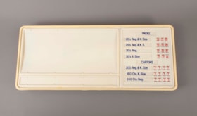
- Large plastic sign with internal backlighting for advertising. The sign has two sections for ad inserts and one section for price display.
- The price display is currently set up advertising the price of packs and cartons of cigarettes
- The first bank of prices are 3 digit with small windows that reveal the number on a roller behind. The second bank of prices are 4 digits.
- The sign was made by CDA Industries in Scarborough, Ontario and is stamped with "JULY 1986"
- There are three labels at the top of the sign including information about how to replace the lamps or reinsert unrolled numbers.
- There is a hole at the top of the sign for the electrical cord to come out.
- There are two white metal brackets attached to the ends of the sign and there is a rusted chain hanging from each bracket.
- The plastic at the bottom right corner on the back is broken and damaged.
- Object History
- Item was used in the Canada Way Food Market owned by Harry Toy between 1975 and the late 2000s. the building sat vacant until sold in 2023.
- See BV023.25.1 for photograph of sign in situ.
- Category
- 08. Communication Artifacts
- Classification
- Advertising Media
- Object Term
- Sign, Advertising
- Marks/Labels
- "PACKS / 20's Reg. & K. Size 5.58 / 25's Reg. & K.S. 5.58 / 30's Reg. 5.58 / 30's K. Size 5.58"
- "CARTONS / 200 Reg. & K.Size 11.11 / 180 Ctn. K. Size 11.11 / 240 Ctn. Reg. 11.11"
- Measurements
- Height: 57.5 cm
- Width: 133.5 cm
- Depth: 13 cm
- Names
- Canada Way Food Market
- Geographic Access
- Canada Way
- Street Address
- 4692 Canada Way
Images

Lake City Industrial Park
https://search.heritageburnaby.ca/link/archivedescription79418
- Repository
- City of Burnaby Archives
- Date
- July, 1976
- Collection/Fonds
- Burnaby Public Library Contemporary Visual Archive Project
- Description Level
- Item
- Physical Description
- 1 photograph : b&w ; 11 x 16 cm mounted on cardboard
- Scope and Content
- Photograph shows a man lying on the grass outside one of the industrial buildings in the Lake City Industrial Park
- Repository
- City of Burnaby Archives
- Date
- July, 1976
- Collection/Fonds
- Burnaby Public Library Contemporary Visual Archive Project
- Physical Description
- 1 photograph : b&w ; 11 x 16 cm mounted on cardboard
- Description Level
- Item
- Record No.
- 556-284
- Access Restriction
- No restrictions
- Reproduction Restriction
- Reproduce for fair dealing purposes only
- Accession Number
- 2013-13
- Scope and Content
- Photograph shows a man lying on the grass outside one of the industrial buildings in the Lake City Industrial Park
- Media Type
- Photograph
- Photographer
- Gardiner, Robert
- Notes
- Scope note taken directly from BPL photograph description.
- 1 b&w copy negative : 10 x 12.5 cm accompanying
- Planning Study Area
- Lake City Area
Images

![Lake City Industrial Park, [1962] thumbnail](/media/hpo/_Data/_Archives_Images/_Unrestricted/001/108-001.jpg?width=280)
Lake City Industrial Park
https://search.heritageburnaby.ca/link/archivedescription34703
- Repository
- City of Burnaby Archives
- Date
- [1962]
- Collection/Fonds
- Burnaby Historical Society fonds
- Description Level
- Item
- Physical Description
- 1 photograph : b&w ; 15.2 x 19.6 cm
- Scope and Content
- Aerial photograph of Lake City Industrial Park.
- Repository
- City of Burnaby Archives
- Date
- [1962]
- Collection/Fonds
- Burnaby Historical Society fonds
- Subseries
- Photographs subseries
- Physical Description
- 1 photograph : b&w ; 15.2 x 19.6 cm
- Description Level
- Item
- Record No.
- 108-001
- Access Restriction
- No restrictions
- Reproduction Restriction
- Reproduce for fair dealing purposes only
- Accession Number
- BHS2007-04
- Scope and Content
- Aerial photograph of Lake City Industrial Park.
- Subjects
- Aerial Photographs
- Buildings - Industrial
- Media Type
- Photograph
- Notes
- Title based on contents of photograph
- Planning Study Area
- Lake City Area
Images
![Lake City Industrial Park, [1962] thumbnail](/media/hpo/_Data/_Archives_Images/_Unrestricted/001/108-001.jpg)

Sign in Lake City Industrial Park
https://search.heritageburnaby.ca/link/archivedescription79421
- Repository
- City of Burnaby Archives
- Date
- September 22, 1976
- Collection/Fonds
- Burnaby Public Library Contemporary Visual Archive Project
- Description Level
- Item
- Physical Description
- 1 photograph : b&w ; 11 x 16 cm mounted on cardboard
- Scope and Content
- Photograph shows a sign on the corner of Production Way and Thunderbird Crescent in the Lake City Industrial Park listing the occupants of Production Way Building # 2. Burnaby Public Library, one of the occupants listed, had moved from this site two months prior to the photograph being taken.
- Repository
- City of Burnaby Archives
- Date
- September 22, 1976
- Collection/Fonds
- Burnaby Public Library Contemporary Visual Archive Project
- Physical Description
- 1 photograph : b&w ; 11 x 16 cm mounted on cardboard
- Description Level
- Item
- Record No.
- 556-286
- Access Restriction
- No restrictions
- Reproduction Restriction
- Reproduce for fair dealing purposes only
- Accession Number
- 2013-13
- Scope and Content
- Photograph shows a sign on the corner of Production Way and Thunderbird Crescent in the Lake City Industrial Park listing the occupants of Production Way Building # 2. Burnaby Public Library, one of the occupants listed, had moved from this site two months prior to the photograph being taken.
- Media Type
- Photograph
- Photographer
- McCarron, John
- Notes
- Scope note taken directly from BPL photograph description.
- 1 b&w copy negative : 10 x 12.5 cm accompanying
- Geographic Access
- Production Way
- Thunderbird Crescent
- Planning Study Area
- Lake City Area
Images

Southern Railway of BC Burnaby
https://search.heritageburnaby.ca/link/archivedescription94306
- Repository
- City of Burnaby Archives
- Date
- February 1994
- Collection/Fonds
- Grover, Elliott & Co. Ltd. fonds
- Description Level
- File
- Physical Description
- 16 photographs : col. negatives ; 35 mm + 1 computer disk ; 14 x 14 cm
- Scope and Content
- Photographs of properties owned by Scott Paper Ltd, including the Doman Sawmill property. Several of the photographs include zoning signs notifying the public that the property is to be developed or redeveloped for Heavy Industrial permitted use.
- Repository
- City of Burnaby Archives
- Date
- February 1994
- Collection/Fonds
- Grover, Elliott & Co. Ltd. fonds
- Physical Description
- 16 photographs : col. negatives ; 35 mm + 1 computer disk ; 14 x 14 cm
- Description Level
- File
- Record No.
- 622-091
- Access Restriction
- No restrictions
- Reproduction Restriction
- No restrictions
- Accession Number
- 2017-39
- Scope and Content
- Photographs of properties owned by Scott Paper Ltd, including the Doman Sawmill property. Several of the photographs include zoning signs notifying the public that the property is to be developed or redeveloped for Heavy Industrial permitted use.
- Subjects
- Buildings - Industrial
- Buildings - Industrial - Mills
- Advertising Medium - Signs and Signboards
- Media Type
- Photograph
- Photographer
- Young, Richard
- Notes
- Transcribed title
- Title transcribed from envelope photographs were originally housed in
- File no. 94-100-O
- Computer disk labelled "Railands.xsl / 2/93"
![Lenkurt Electric Company, [1957] thumbnail](/media/Hpo/_Data/_Archives_Images/_Unrestricted/001/099-001.jpg?width=280)
Lenkurt Electric Company
https://search.heritageburnaby.ca/link/archivedescription34690
- Repository
- City of Burnaby Archives
- Date
- [1957]
- Collection/Fonds
- Burnaby Historical Society fonds
- Description Level
- Item
- Physical Description
- 1 photograph : b&w ; 20.3 x 25.3 cm
- Scope and Content
- Photograph of aerial view of the Lenkurt Electric Company at 6960 Lougheed Highway (later renumbered 7018 Lougheed Highway). A sign on the top of the building reads, "Lenkurt." An information sheet from the Company Relation Division of Lenkurt attached to the back of the photograph reads, "Aerial…
- Repository
- City of Burnaby Archives
- Date
- [1957]
- Collection/Fonds
- Burnaby Historical Society fonds
- Subseries
- Photographs subseries
- Physical Description
- 1 photograph : b&w ; 20.3 x 25.3 cm
- Description Level
- Item
- Record No.
- 099-001
- Access Restriction
- No restrictions
- Reproduction Restriction
- Reproduce for fair dealing purposes only
- Accession Number
- BHS2007-04
- Scope and Content
- Photograph of aerial view of the Lenkurt Electric Company at 6960 Lougheed Highway (later renumbered 7018 Lougheed Highway). A sign on the top of the building reads, "Lenkurt." An information sheet from the Company Relation Division of Lenkurt attached to the back of the photograph reads, "Aerial view of a 34,000 square foot building including a 19,000 square foot extension to the existing 15,000 square foot plant of Lenkurt Electric Co. of Canada Ltd. in North Burnaby, B.C., as at May 10th, 1957. / The building is situated on 20 acres of land and faces north onto Lougheed Highway."
- Names
- Lenkurt Electric Company
- Media Type
- Photograph
- Photographer
- Commercial Illustrators Industrial Photographers
- Notes
- Title based on contents of photograph
- Stamp and annotation on back of photograph reads, "TA. 8817 / Commerical Illustrators / Industrial Photographers / 601 Denman St., Vancouver 5, B.C. / File No. 1080-1"
- Geographic Access
- Lougheed Highway
- Street Address
- 7018 Lougheed Highway
- Historic Neighbourhood
- Lozells (Historic Neighbourhood)
- Planning Study Area
- Government Road Area
Images
![Lenkurt Electric Company, [1957] thumbnail](/media/Hpo/_Data/_Archives_Images/_Unrestricted/001/099-001.jpg)
![Trans Mountain Oil Pipe Line Co., [1958] thumbnail](/media/Hpo/_Data/_Archives_Images/_Unrestricted/001/097-001.jpg?width=280)
Trans Mountain Oil Pipe Line Co.
https://search.heritageburnaby.ca/link/archivedescription34688
- Repository
- City of Burnaby Archives
- Date
- [1958]
- Collection/Fonds
- Burnaby Historical Society fonds
- Description Level
- Item
- Physical Description
- 1 photograph : b&w ; 20.4 x 25.3 cm
- Scope and Content
- Aerial photograph of the Trans Mountain Oil Pipe Line Co. storage tanks on Burnaby Mountain.
- Repository
- City of Burnaby Archives
- Date
- [1958]
- Collection/Fonds
- Burnaby Historical Society fonds
- Subseries
- Photographs subseries
- Physical Description
- 1 photograph : b&w ; 20.4 x 25.3 cm
- Description Level
- Item
- Record No.
- 097-001
- Access Restriction
- No restrictions
- Reproduction Restriction
- Reproduce for fair dealing purposes only
- Accession Number
- BHS2007-04
- Scope and Content
- Aerial photograph of the Trans Mountain Oil Pipe Line Co. storage tanks on Burnaby Mountain.
- Media Type
- Photograph
- Photographer
- Commercial Illustrators Industrial Photographers
- Notes
- Title based on contents of photograph
- Stamp and annotation on back of photograph reads, "TA. 8817 / Commerical Illustrators / Industrial Photographers / 601 Denman St., Vancouver 5, B.C. / File No. 9412-13"
- Geographic Access
- Burnaby Mountain Conservation Area
- Shellmont Street
- Underhill Avenue
- Planning Study Area
- Lake City Area
Images
![Trans Mountain Oil Pipe Line Co., [1958] thumbnail](/media/Hpo/_Data/_Archives_Images/_Unrestricted/001/097-001.jpg)

Aerial photograph of Dominion Bridge Company's Burnaby plant
https://search.heritageburnaby.ca/link/museumdescription1736
- Repository
- Burnaby Village Museum
- Date
- August 1946
- Collection/Fonds
- Burnaby Village Museum Photograph collection
- Description Level
- Item
- Physical Description
- 1 photograph : b&w ; 11.5 x 16.5 cm
- Scope and Content
- Aerial photograph of Dominion Bridge Company's Burnaby Plant taken 1000 feet above ground from a Fleet Canuck (a Canadian designed and built light aircraft).
- Repository
- Burnaby Village Museum
- Collection/Fonds
- Burnaby Village Museum Photograph collection
- Description Level
- Item
- Physical Description
- 1 photograph : b&w ; 11.5 x 16.5 cm
- Scope and Content
- Aerial photograph of Dominion Bridge Company's Burnaby Plant taken 1000 feet above ground from a Fleet Canuck (a Canadian designed and built light aircraft).
- Subjects
- Aerial Photographs
- Buildings - Industrial
- Names
- Dominion Bridge Company
- Geographic Access
- Henning Drive
- Street Address
- 3880 Henning Drive
- Accession Code
- BV003.46.3
- Access Restriction
- No restrictions
- Reproduction Restriction
- No known restrictions
- Date
- August 1946
- Media Type
- Photograph
- Historic Neighbourhood
- Broadview (Historic Neighbourhood)
- Planning Study Area
- West Central Valley Area
- Scan Resolution
- 600
- Scan Date
- 09-Jun-09
- Scale
- 100
- Notes
- Title based on contents of photograph
- Note in black felt pen on recto of photograph reads: "FROM 1000' / AUG. 1946"
- Note in black ink on verso of photograph reads: "D.B. Co. - Burnaby Plant./ Taken from 1000' - in fleet Canuck/ with Brub - Aug. 1946."
Images

![Burnaby Mountain Oil Storage, [1960] thumbnail](/media/hpo/_Data/_Archives_Images/_Unrestricted/001/109-001.jpg?width=280)
Burnaby Mountain Oil Storage
https://search.heritageburnaby.ca/link/archivedescription34704
- Repository
- City of Burnaby Archives
- Date
- [1960]
- Collection/Fonds
- Burnaby Historical Society fonds
- Description Level
- Item
- Physical Description
- 1 photograph : b&w ; 15.2 x 19.5 cm
- Scope and Content
- Aerial photograph of oil storage tanks on Burnaby Mountain, possibly those of Trans Mountain Oil Pipe Line Co. at the top of Underhill Avenue.
- Repository
- City of Burnaby Archives
- Date
- [1960]
- Collection/Fonds
- Burnaby Historical Society fonds
- Subseries
- Photographs subseries
- Physical Description
- 1 photograph : b&w ; 15.2 x 19.5 cm
- Description Level
- Item
- Record No.
- 109-001
- Access Restriction
- No restrictions
- Reproduction Restriction
- Reproduce for fair dealing purposes only
- Accession Number
- BHS2007-04
- Scope and Content
- Aerial photograph of oil storage tanks on Burnaby Mountain, possibly those of Trans Mountain Oil Pipe Line Co. at the top of Underhill Avenue.
- Media Type
- Photograph
- Notes
- Title based on contents of photograph
- Geographic Access
- Burnaby Mountain Conservation Area
- Shellmont Street
- Underhill Avenue
- Planning Study Area
- Lake City Area
Images
![Burnaby Mountain Oil Storage, [1960] thumbnail](/media/hpo/_Data/_Archives_Images/_Unrestricted/001/109-001.jpg)

Road Construction
https://search.heritageburnaby.ca/link/archivedescription79978
- Repository
- City of Burnaby Archives
- Date
- September 20, 1976
- Collection/Fonds
- Burnaby Public Library Contemporary Visual Archive Project
- Description Level
- Item
- Physical Description
- 1 photograph : b&w ; 11 x 16 cm mounted on cardboard
- Scope and Content
- Photograph shows view of road construction on Broadway behind the Lake City Industrial Park.
- Repository
- City of Burnaby Archives
- Date
- September 20, 1976
- Collection/Fonds
- Burnaby Public Library Contemporary Visual Archive Project
- Physical Description
- 1 photograph : b&w ; 11 x 16 cm mounted on cardboard
- Description Level
- Item
- Record No.
- 556-534
- Access Restriction
- No restrictions
- Reproduction Restriction
- Reproduce for fair dealing purposes only
- Accession Number
- 2013-13
- Scope and Content
- Photograph shows view of road construction on Broadway behind the Lake City Industrial Park.
- Media Type
- Photograph
- Photographer
- Campbell, Peg
- Notes
- Scope note taken directly from BPL photograph description.
- 1 b&w copy negative : 10 x 12.5 cm accompanying
- Geographic Access
- Broadway
- Planning Study Area
- Lake City Area
Images

sign
https://search.heritageburnaby.ca/link/museumartifact91627
- Repository
- Burnaby Village Museum
- Accession Code
- BV022.21.101
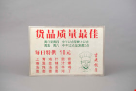
- Description
- Sign designed to look like a menu board for a movie prop. The board is printed on an aluminum frame dry erase board.
- The front of the board is white and has Chinese characters printed in red and green text with an illustration of a person in a chef's hat on the right side.
- The english translation is provided on the back of the board in the technical specifications.
- The technical specifications on the back include information about the scale, text colours, and movie information like director, production design, set number.
- Object History
- "Jimmy's Dumplings" prop created as part of a street scene in movie Fantastic Four 2.
- Jimmy Chow worked in TV and film as a property master for more than 42 years. A property master is responsible for building and procuring props that actors handle and use. This sometimes means making replica items that are lighter, false or make filming easier on the actor. This differs from set decoration, which uses props to create a backdrop and is less central to the action on set.
- Jimmy Chow was responsible for designing, managing, and sourcing props for films such as: BFG, Warcraft: The Beginning, X-Men 2, Fantastic Four, Watchman, Tron: Legacy, Little Women, Seven Years in Tibet, Shanghai Noon, The Shipping News, Fantastic Four: Rise of the Silver Surfer, The Changeling, Man of Steel (Superman), Snow Falling on Cedars, Legends of the Fall, And the Sea Will Tell, and Once a Thief.
- He entered the film industry in 1973 working for CBC Vancouver and gained valuable experience working on the set of the television series The Beachcombers, which launched his career.
- Category
- 08. Communication Artifacts
- Classification
- Advertising Media
- Object Term
- Sign, Advertising
- Marks/Labels
- English Translation: Best Selection / Sun-Thurs 12pm-12am / Fri-Sat 12pm-2am / Daily Specials From 10 Yuan / Shanghai Noodle Soup / Green Onion with Braised Noodles / Souple Noodles with Shredded Chicken / Fried Rice Noodles with Beef / Diced Chicken with Sauce / Jimmy Dumpling
- Names
- Chow, Hipman "Jimmy"
Images

sign
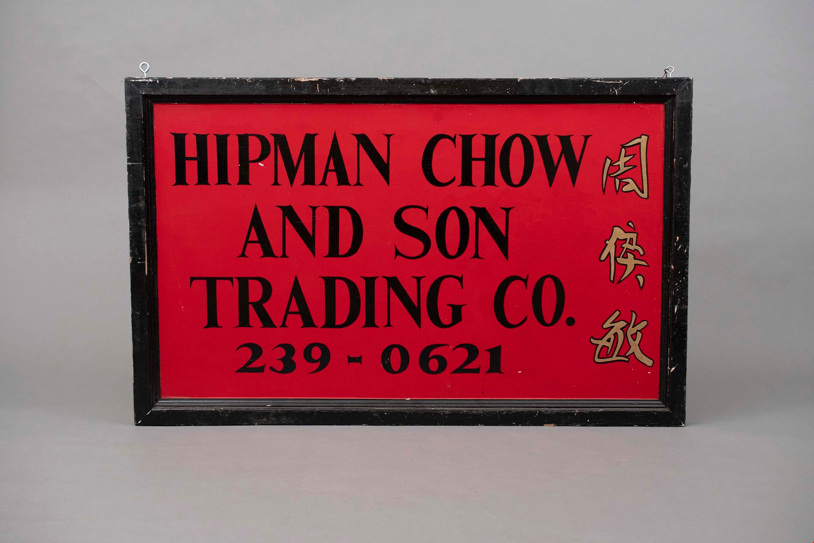
https://search.heritageburnaby.ca/link/museumartifact91632
- Repository
- Burnaby Village Museum
- Accession Code
- BV022.21.106
- Description
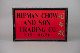
- Sign created to be a prop in a movie. The sign is made of wood and has text painted on both sides. The frame of the sign is painted black and distressed in areas revealing the natural wood.
- The sign itself has a red background with black text in English and Chinese characters in gold.
- There are two cup hooks at the top of the sign, each is a different size. The smaller cup hook has some wire strung through it.
- Object History
- Jimmy Chow worked in TV and film as a property master for more than 42 years. A property master is responsible for building and procuring props that actors handle and use. This sometimes means making replica items that are lighter, false or make filming easier on the actor. This differs from set decoration, which uses props to create a backdrop and is less central to the action on set.
- Jimmy Chow was responsible for designing, managing, and sourcing props for films such as: BFG, Warcraft: The Beginning, X-Men 2, Fantastic Four, Watchman, Tron: Legacy, Little Women, Seven Years in Tibet, Shanghai Noon, The Shipping News, Fantastic Four: Rise of the Silver Surfer, The Changeling, Man of Steel (Superman), Snow Falling on Cedars, Legends of the Fall, And the Sea Will Tell, and Once a Thief.
- He entered the film industry in 1973 working for CBC Vancouver and gained valuable experience working on the set of the television series The Beachcombers, which launched his career.
- Reference
- "HIPMAN CHOW / AND SON / TRADING CO. / 239-0621"
- Category
- 08. Communication Artifacts
- Classification
- Advertising Media
- Object Term
- Sign, Advertising
- Measurements
- Height: 76.5 cm
- Width: 122.5 cm
- Depth: 6.5 cm
- Names
- Chow, Hipman "Jimmy"
Images

Simon Fraser Townhouses
https://search.heritageburnaby.ca/link/archivedescription79955
- Repository
- City of Burnaby Archives
- Date
- September 27, 1976
- Collection/Fonds
- Burnaby Public Library Contemporary Visual Archive Project
- Description Level
- Item
- Physical Description
- 1 photograph : b&w ; 11 x 16 cm mounted on cardboard
- Scope and Content
- Photograph shows a view of Simon Fraser Townhouses and Lake City Industrial Park from Salish Court Tower West. The crane pictured is on one of the Salish Court Towers.
- Repository
- City of Burnaby Archives
- Date
- September 27, 1976
- Collection/Fonds
- Burnaby Public Library Contemporary Visual Archive Project
- Physical Description
- 1 photograph : b&w ; 11 x 16 cm mounted on cardboard
- Description Level
- Item
- Record No.
- 556-521
- Access Restriction
- No restrictions
- Reproduction Restriction
- Reproduce for fair dealing purposes only
- Accession Number
- 2013-13
- Scope and Content
- Photograph shows a view of Simon Fraser Townhouses and Lake City Industrial Park from Salish Court Tower West. The crane pictured is on one of the Salish Court Towers.
- Subjects
- Aerial Photographs
- Media Type
- Photograph
- Photographer
- Campbell, Peg
- Notes
- Scope note taken directly from BPL photograph description.
- 1 b&w copy negative : 10 x 12.5 cm accompanying
- Planning Study Area
- Lake City Area
Images


Standard Oil Company
https://search.heritageburnaby.ca/link/archivedescription34567
- Repository
- City of Burnaby Archives
- Date
- 1958
- Collection/Fonds
- Burnaby Historical Society fonds
- Description Level
- Item
- Physical Description
- 1 photograph : b&w ; 28.0 x 35.8 cm
- Scope and Content
- Aerial photograph of the Standard Oil Company Stanovan Refinery storage and shipping area, along the Burrard Inlet.
- Repository
- City of Burnaby Archives
- Date
- 1958
- Collection/Fonds
- Burnaby Historical Society fonds
- Subseries
- Photographs subseries
- Physical Description
- 1 photograph : b&w ; 28.0 x 35.8 cm
- Description Level
- Item
- Record No.
- 052-003
- Access Restriction
- No restrictions
- Reproduction Restriction
- Reproduce for fair dealing purposes only
- Accession Number
- BHS2007-04
- Scope and Content
- Aerial photograph of the Standard Oil Company Stanovan Refinery storage and shipping area, along the Burrard Inlet.
- Media Type
- Photograph
- Notes
- Title based on contents of photograph
- Geographic Access
- Eton Street
- Street Address
- 4403 Eton Street
- Historic Neighbourhood
- Vancouver Heights (Historic Neighbourhood)
- Planning Study Area
- Burnaby Heights Area
Images


Standard Oil Company
https://search.heritageburnaby.ca/link/archivedescription34568
- Repository
- City of Burnaby Archives
- Date
- 1958
- Collection/Fonds
- Burnaby Historical Society fonds
- Description Level
- Item
- Physical Description
- 1 photograph : b&w ; 27.8 x 35.5 cm
- Scope and Content
- Aerial photograph of the Standard Oil Company Stanovan Refinery, Burrard Inlet.
- Repository
- City of Burnaby Archives
- Date
- 1958
- Collection/Fonds
- Burnaby Historical Society fonds
- Subseries
- Photographs subseries
- Physical Description
- 1 photograph : b&w ; 27.8 x 35.5 cm
- Description Level
- Item
- Record No.
- 052-004
- Access Restriction
- No restrictions
- Reproduction Restriction
- Reproduce for fair dealing purposes only
- Accession Number
- BHS2007-04
- Scope and Content
- Aerial photograph of the Standard Oil Company Stanovan Refinery, Burrard Inlet.
- Media Type
- Photograph
- Photographer
- Aero Surveys Limited
- Notes
- Title based on contents of photograph
- Back of photo stamped: "Photo by Aero Surveys Limited, Vancouver, BC, Canada / Identification No.: BO-58-444"
- Geographic Access
- Eton Street
- Street Address
- 4403 Eton Street
- Historic Neighbourhood
- Vancouver Heights (Historic Neighbourhood)
- Planning Study Area
- Burnaby Heights Area
Images

![Trans Mountain Pipe Line loading dock, [1958] thumbnail](/media/Hpo/_Data/_Archives_Images/_Unrestricted/001/098-001.jpg?width=280)
Trans Mountain Pipe Line loading dock
https://search.heritageburnaby.ca/link/archivedescription34689
- Repository
- City of Burnaby Archives
- Date
- [1958]
- Collection/Fonds
- Burnaby Historical Society fonds
- Description Level
- Item
- Physical Description
- 1 photograph : b&w ; 20.4 x 25.3 cm
- Scope and Content
- Aerial photograph of the Trans Mountain Pipe Line Westridge loading dock on Burrard Inlet. Houses are visible in the background, and railroad tracks along the edge of the inlet.
- Repository
- City of Burnaby Archives
- Date
- [1958]
- Collection/Fonds
- Burnaby Historical Society fonds
- Subseries
- Photographs subseries
- Physical Description
- 1 photograph : b&w ; 20.4 x 25.3 cm
- Description Level
- Item
- Record No.
- 098-001
- Access Restriction
- No restrictions
- Reproduction Restriction
- Reproduce for fair dealing purposes only
- Accession Number
- BHS2007-04
- Scope and Content
- Aerial photograph of the Trans Mountain Pipe Line Westridge loading dock on Burrard Inlet. Houses are visible in the background, and railroad tracks along the edge of the inlet.
- Media Type
- Photograph
- Photographer
- Commercial Illustrators Industrial Photographers
- Notes
- Title based on contents of photograph
- Stamp and annotation on back of photograph reads, "TA. 8817 / Commerical Illustrators / Industrial Photographers / 601 Denman St., Vancouver 5, B.C. / File No. 9412-2"
- Historic Neighbourhood
- Lochdale (Historic Neighbourhood)
- Planning Study Area
- Westridge Area
Images
![Trans Mountain Pipe Line loading dock, [1958] thumbnail](/media/Hpo/_Data/_Archives_Images/_Unrestricted/001/098-001.jpg)