Narrow Results By
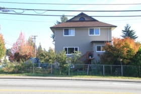
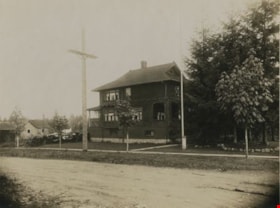
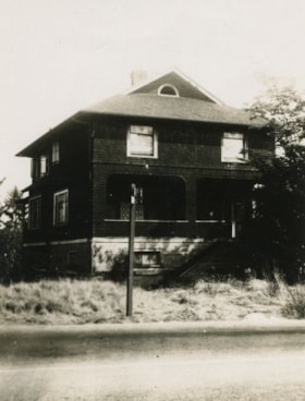
Thomas & Margaret Coldicutt Residence
https://search.heritageburnaby.ca/link/landmark647
- Repository
- Burnaby Heritage Planning
- Description
- Residential building.
- Associated Dates
- 1911
- Street View URL
- Google Maps Street View
- Repository
- Burnaby Heritage Planning
- Geographic Access
- 6th Street
- Associated Dates
- 1911
- Description
- Residential building.
- Heritage Value
- This house was built by Thomas Davis Coldicutt (1879-1970) and Margaret Jane Coldicutt, pre-eminent local citizens. Thomas Coldicutt was born in Birmingham and arrived in Canada in 1900, finding success in the steamboat industry. In 1902, he married Margaret Jane Styler who had been born in Redditch, Worcester, England, and in 1908 they settled in East Burnaby–some of the first pioneers to the area–and established a fruit farm. Thomas had a successful real estate, insurance and brokerage business, and was elected as a councillor for East Burnaby in 1909. He was also active in civic, political and social circles in Burnaby and became president of the Burnaby Board of Trade. "East Burnaby is booming and the signs of prosperity that may be seen on every hand. Most of these are substantial dwellings, such as effect a permanent improvement to the countryside. Among those whose homes have been completed, or on the point of completion may be mentioned. Councillor Coldicutt, who has built himself a habitation on Second Avenue at a cost of $4,000. (The British Columbian, 1911). In 1913, Coldicutt sold his original farm described as “the show place of Burnaby” to the Burnaby School Board for the development of Second Street School and this house was moved from Second Street and Sixteenth Avenue to this site. It has been extensively altered, but retains its original form, scale and massing.
- Locality
- East Burnaby
- Historic Neighbourhood
- East Burnaby (Historic Neighbourhood)
- Planning Study Area
- Edmonds Area
- Area
- 557.42
- Contributing Resource
- Building
- Ownership
- Private
- Street Address
- 7510 6th Street
- Street View URL
- Google Maps Street View
Images
West Central Valley Neighbourhood
https://search.heritageburnaby.ca/link/landmark778
- Repository
- Burnaby Heritage Planning
- Associated Dates
- 1955-2008
- Heritage Value
- The West Central Valley Neighbourhood is home to the Bridge Business Park and is a primarily industrial neighbourhood. Similar to the adjacent Dawson-Delta Neighbourhood, West Central Valley offers businesses convenient access to major roads and highways.
- Historic Neighbourhood
- Broadview (Historic Neighbourhood)
- Planning Study Area
- West Central Valley Area
Images
Windsor Neighbourhood
https://search.heritageburnaby.ca/link/landmark803
- Repository
- Burnaby Heritage Planning
- Associated Dates
- 1955-2008
- Heritage Value
- The Windsor Neighbourhood comprises a number of different districts with different characteristics. To the north, stretching to the border of the Deer Lake Park, is the primarily residential area that was developed after the building boom of the 1950s and now consists of a mix of single-family and multi-family housing. To the south, from Kingsway to the Skytrain line, an industrial area was maintained along with a significant commercial corridor along Kingsway. In recent years, the growth and development of this area has been guided by the Royal Oak Community Plan adopted by Council in 1999.
- Planning Study Area
- Windsor Area


