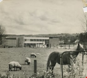
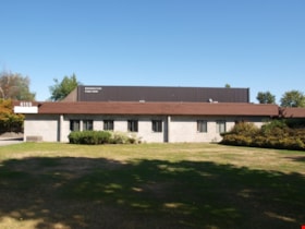
Burnaby Winter Club
https://search.heritageburnaby.ca/link/landmark816
- Repository
- Burnaby Heritage Planning
- Geographic Access
- Canada Way
- Associated Dates
- 1956
- Heritage Value
- Skating on Deer Lake and Burnaby Lake was the inspiration to form the Burnaby Winter Club in the 1950s. In 1958, the volunteer group opened an indoor ice facility, still operating today at 4990 Canada Way. Originally, the facility boasted 8 sheets of curling ice, that were used to capacity by the more than 500 family and individual members in the heyday of the Club. The Winter Club was a social centre: in addition to curling, it was a popular place for banquets and dances, and a place for families to spend time together. In the 1960s, the eight sheets of curling ice were reduced to five, to make room for a sheet of hockey ice for the members’ children. Volunteer coaches were committed to excellence, and the Club produced many professional hockey players. By 1964, the Club’s first future NHL player was playing: Pee Wee player Jack McIlhargey.
- Historic Neighbourhood
- Burnaby Lake (Historic Neighbourhood)
- Planning Study Area
- Douglas-Gilpin Area
- Street Address
- 4990 Canada Way
- Street View URL
- Google Maps Street View
Images
Kensington Arena
https://search.heritageburnaby.ca/link/landmark787
- Repository
- Burnaby Heritage Planning
- Geographic Access
- Curtis Street
- Associated Dates
- 1973
- Heritage Value
- In 1972, the Burnaby Parks Commission considered numerous requests from the community to increase the available ice rink surfaces in the city and voted to build a new full-sized rink instead of adding to the existing municipal rink facility. The new arena was to be situated in North Burnaby and was opened in 1973 adjacent to Kensington Park.
- Planning Study Area
- Parkcrest-Aubrey Area
- Street Address
- 6159 Curtis Street
- Street View URL
- Google Maps Street View
Images
Vancouver Road (Kingsway)
https://search.heritageburnaby.ca/link/landmark729
- Repository
- Burnaby Heritage Planning
- Associated Dates
- 1860
- Heritage Value
- The street we know as Kingsway is one of the legacies of the Royal Engineers' military defences for New Westminster. The fear of an American attack prompted the construction of the False Creek trail - later known as Vancouver Road and now Kingsway - in 1860 to connect the capital city to the ice-free salt water harbour at English Bay.
- Historic Neighbourhood
- Central Park (Historic Neighbourhood)
- Edmonds (Historic Neighbourhood)
- Planning Study Area
- Maywood Area
- Marlborough Area
- Windsor Area
- Kingsway-Beresford Area
- Stride Avenue Area
- Edmonds Area


![Gilley Brothers Logging team, [1895]. . thumbnail](/media/hpo/_Data/_Archives_Images/_Unrestricted/371/461-003.jpg?width=280)